On a clear April morning, I walk out on the wind- and wave-swept sand spit that shelters Limatour Estero from the Pacific swells. The beach has been swept clean of footprints and graded flat by the last high tide. Migrant shorebirds–sanderlings, willets, and whimbrels–all molting into breeding dress, probe for mole crabs in the backwash of receding waves. In the distance, the white headlands of Drakes Bay frame the contour of the coast, a diorama set against a backdrop of a cloudless, indigo sky. It’s a peaceful stroll, accompanied by the hypnotic rhythm of the waves. Eventually, out near the end of the spit, anomalous forms take shape. Lifting my binoculars, I make out a large roost of white pelicans. Nearby, another congregation is resting on the quiet shore, several dozen harbor seals gathered to give birth and nurse their pups. I kneel behind a hummock to observe unnoticed. For an hour or two I watch while these aboriginal beings go about their ancient duties–preening, nursing, resting.
Few places on earth are as composed, as sublime really, as this place, on this day.
And yet, it could so easily not have been. Back near the base of the spit are several incongruous graded areas, sites intended for vacation homes on the ridge of the dunes. How fortunate we are that some determined people had a different vision, and backed that up with the hard work necessary to create a refuge for both wildlife and humans seeking wide-open natural landscapes.
In the following pages we honor the creation of Point Reyes National Seashore 50 years ago by presenting portraits of five of the signature habitats of this magical place.
Geology and Geography


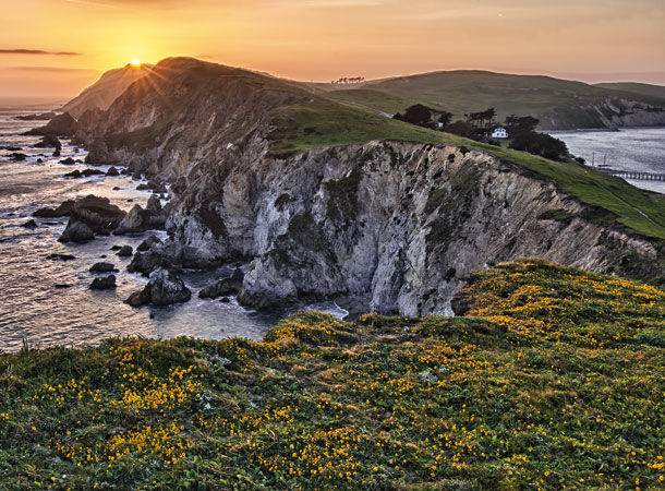
The Point Reyes peninsula was dubbed an “Island in Time” by San Francisco Chronicle writer Harold Gilliam, a sobriquet that captures both the singular and transitory nature of the peninsula–a huge chunk of granitic bedrock wrenched from the southern Sierra Nevada about 100 million years ago and adrift ever since, working its way up the coast, pushed along by the tectonic forces generated by the perennial collision of the North American and Pacific plates. This itinerant geology is sutured, if temporarily, to the western boundary of the North American tectonic plate. The expression of this contact zone, the San Andreas Fault, comes ashore at Bolinas Lagoon, stretches northward beneath the deceptively tranquil Olema Valley, and heads offshore again at the mouth of Tomales Bay. This plate boundary is considered “active,” and the northwestward movement of the Pacific Plate is relatively speedy in geologic time, averaging two to three inches a year, but predisposed to much more abrupt jolts when the fault gives way, as it did in the great 1906 earthquake, which left visible scars in the landscape around Olema. Our ready access from the core Bay Area to this wild and recondite terrane is thus a passing privilege.


The current position of the peninsula, jutting out into the Pacific Ocean at 38 degrees north and 123 degrees west, puts it directly in the path of winds and ocean currents tacking southeasterly across the North Pacific from the Gulf of Alaska. These prevailing currents engender an upwelling of cold water that dominates the peninsula’s weather regime, moderating the climate to such a degree that average monthly temperatures on the land are only slightly higher than that of the open ocean. This conformity to the climate of the California Current– with its remarkably consistent temperature–provides the peninsula with one of the most equable climates on the planet. Distinctions between winter and spring are befogged. Flowers bloom and hummingbirds nest in midwinter. This hospitable climate accommodates an overlap of flora and fauna from both north and south. Plant species with neotropical affinities reach their northern limit here, intermixing with species of boreal origins. Manzanita and sagebrush grow alongside Douglas fir and redwood. Likewise for the animals; elephant seals breed no farther north while northern sea lions occur no farther south. So, here we experience a biodiversity seldom encountered on the North American continent.
Human History

The first European known to have glimpsed the peninsula was Portuguese mariner João Rodrigues Cabrilho as he explored the northern limits of New Spain’s west coast in 1543. Many historians believe that Englishman Francis Drake steered his listing Golden Hinde into what is now known as Drakes Bay in 1579. Two decades later Spanish explorer Sebastian Vizcaino passed the peninsula on the 12th day of Christmas, El Dia de los Reyes, and named it La Punta de los Reyes. The name eventually morphed into Point Reyes, a phrase capturing its hybrid European history.
Despite occasional visitors from Europe, the peninsula had remained the realm of the native Coast Miwok, tule elk, and grizzly bear for millennia. With the establishment of the Spanish Mission San Rafael Archangel in 1817, everything changed. The indigenous people were rounded up and brought to the mission. In place of their villages, Mexican ranchos were established, domestic livestock was brought to the fog-fed coastal prairies of western Marin County, and much of the perennial grasslands was converted to pasturelands dominated by annual European grasses.
After the declaration of California statehood in 1850, the ranchos came under American ownership, with surnames Garcia and Briones replaced by Shafter, Randall, and Nelson. By the 1860s the butter and milk era was well under way, as the peninsula’s ranches supplied the markets of a burgeoning San Francisco. Through various influences over the next century and a quarter, the landscape was dramatically altered, but its original nature managed to persist, if cryptically, in native rootstocks and seed banks and on slopes and ravines too steep for grazing or logging.

Birth of a Park
As early as 1928, eminent landscape architect Fredrick Law Olmsted Jr. had proposed creating a national park on the “hilly, forested, mesa, canyon, beach, and bluff lands fronting on Drakes Bay, Pacific Ocean, and Tomales Bay.” In 1957, George L. Collins, regional chief of recreation planning for the National Park Service, surveyed the peninsula from the air and came to much the same opinion. Collins, a passionate conservationist and Marin County resident, took the concept beyond words and nurtured the idea of incorporating the peninsula into the National Park system. Three politicians–Senator Clair Engle, Congressman Clem Miller, and county supervisor Peter Behr–provided crucial support for the legislation, helping to overcome such obstacles as the designs of developers and the concerns of local ranchers. On September 13, 1962, President John F. Kennedy signed the act establishing Point Reyes National Seashore.
The narrative of the enabling legislation reveals a complicated interaction between local and national interests that continues today. The park’s administration has had to negotiate a delicate balance between human use and requirements to protect and preserve natural resources for future generations. Managing this tension between preservation, agriculture, and recreation has been an ongoing challenge. Meanwhile, this 71,000-acre park serves as a wilderness magnet for people from the Bay Area and around the world: More than two million people visit the park each year to hike, ride, camp, and enjoy the peninsula’s natural beauty.
-

Clouds over Abbotts Lagoon at sunset. Photo (c) Bill Helsel 2010.
Stewardship

“Biodiversity” was not a concept in common currency 50 years ago. The main rationales for establishing the park were the scenic and recreational opportunities afforded so close to a sprawling urban area. But after the park was established, areas formerly inaccessible to the public were opened up and visitors began to catalog an impressive richness of species. A dawning understanding of the peninsula’s unique natural attributes attracted scientists and naturalists, as well as a public hungry for experiences beyond the clamor of urban life.
In 1968, several intrepid birders, realizing that many rare migrants were showing up on the peninsula, founded the Point Reyes Bird Observatory (now PRBO Conservation Science) and began monitoring the peninsula’s birdlife, eventually recording half of North American avifauna in this one place. The California Native Plant Society began cataloging a plethora of native plants, including about 50 rare, threatened, and endangered taxa. Some were even unique to the area and named fora Point Reyes–a bird’s-beak, a checkerbloom, a meadowfoam, a rein orchid. And a few of the peninsula’s mammals have been identified as separate subspecies–Point Reyes mountain beaver and Point Reyes jumping mouse.

For the first several decades after the park’s establishment, resources were directed mostly toward visitor services, trail maintenance, and laissez-faire land management. In the mid-1990s, a new superintendent shifted the focus to resource management, which led to the establishment of the Pacific Coast Science and Learning Center, dedicated to “scientific inquiry, supporting science-based decision making, and promoting resource stewardship through partnerships.”
This transformation in focus was fortuitous. In October 1995, a wildfire ignited atop Mount Vision, incinerating over 12,000 acres of conifer and coastal scrub habitat. Fortunately, despite the intensity of the fire and serious damage to many homes along Inverness Ridge, no residents or park visitors died and research teams were ready to document the habitat devastation and study the remarkable recovery that followed.
The next decade would witness another renewal: the purchase of the 550-acre Giacomini Dairy at the south end of Tomales Bay with the goal of restoring its historic tidal wetlands. In October 2008, after nearly a decade of negotiation and planning, the man-made levees that had been built in 1947 were breached and the tides soon reclaimed the pasturelands.
Monitoring of the post-fire regeneration and the wetland restoration is ongoing, providing a landscape-scale laboratory for the study of natural succession and habitat recovery.
The 50th anniversary of Point Reyes National Seashore provides not only an opportunity to consider the changes that have occurred to the peninsula to appreciate the resilience of its habitats, and to recognize its biodiversity, but also to celebrate the protection of its craggy headlands and vast ocean vistas, its sandy beaches and sheltered estuaries, its conifer-covered ridgelines and fog-shrouded coastal scrub, its wild-flower-covered prairie and pastoral zone, and its silent dunes, all of which, together, make the Point Reyes peninsula among the most treasured of our Bay Area landscapes.