.jpg)
At the edge of the Bay—where uplands slope down to wetlands and creeks meander into marshes—people and nature have met and mingled for hundreds of years.
Native Americans often settled near the shoreline, where the fishing and hunting were rich. Hundreds of years later, European settlers discovered that the shoreline was an excellent spot for shipping cattle, grain, and redwood from the East Bay hills—and even for manufacturing and shipping explosives. Today residents are still drawn to the Bay’s fringe, and although some areas are quite altered—even man-made in many cases—these areas remain biologically diverse, with landforms ranging from sandy beaches to mudflats and salt marshes to rocky points and bluffs. The East Bay Regional Park District (EBRPD) manages nearly 50 miles of publicly accessible shoreline that offer a variety of experiences, encouraging visitors to imagine our shoreline’s natural—and sometimes unnatural—past.
One place where the lure of the Bay is obvious is at Crown Beach, a man-made beach on the Alameda shore. Walking along the water’s edge, I’m surrounded by fast-moving people, from windsurfers and kite surfers (windy Crown Beach is one of the top spots in the world for this popular new sport) to joggers and walkers. Up on the sand, young architects craft their castles while older folks lounge on beach towels or picnic in the grassy area.

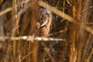
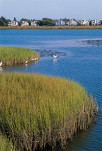
- The salt marshes of Elsie Roemer Bird Sanctuary at thesouthern end of Crown Beach sit across the channel from a residentialsection of Alameda’s Bay Farm Island. These marshes provide criticalhabitat for endangered California clapper rails. Photo by Paul Frank, www.coastvisions.com.
While the beach is full of people today, in the summer of 1967 it looked very different. People were coming into the visitor center to tell us that sharks—leopard sharks, brown smooth-hound sharks, and bat rays—were washing up on the beach, recalls Ron Russo, the district’s retired chief naturalist. They weren’t panicked, but they were concerned about these live sharks flopping around on the beach. It was a shock to us, too; we had just begun managing the area as a regional park.
The sharks, some living and many dead, started washing ashore in June, recalls Russo, and by August, the phenomenon had reached a peak; volunteers and EBRPD personnel pulled more than 1,000 sharks off the beach that month. When they tried to put the live sharks back in the water, the fish simply beached themselves again. Russo’s theory on the mass stranding is that the Bay had just been dredged for the BART tube, which may have stirred up buried pesticides, heavy metals, and chlorinated hydrocarbons in loads that could have disoriented and killed the sharks and rays. These strandings have happened periodically since then as well, says Russo, who thinks they are tied to seasonal dredging events in the Bay. But, he adds, sharks frequent the beach not only during strandings. What many people don’t know is that the rays and sharks are often present at Crown Beach, swimming around in the shallows, feeding on worms and crabs along the shore during high tide—invisible to humans but there nonetheless. They’re very sensitive to disturbance, so they’re not likely to hang around if a bunch of kids are swimming there, he says, adding that they pose no danger to humans.
The 1967 shark beaching isn’t the only odd reminder that our much-altered shorelines remain wild places: This year, for just the second time on record, a school of California grunion rode a high tide into Crown Beach to spawn under the full moon. Coastal populations of these slippery, silvery fish normally spawn on sandy beaches south of Monterey, dancing and flipping about; the female buries herself tail first in the sand, laying her eggs, while the male wraps himself around her, fertilizing the eggs. The fish leave the beach by catching a wave back out to sea—or in this case, the Bay.
So although Crown Beach may appear in summer and fall to be primarily a people beach, other species are there, even if they’re often invisible to us. In the winter, says Russo, Crown Beach belongs to the birds. When the tide is out, you’ll see willets, dunlin, sandpipers, avocets—all kinds of species in the mudflats and receding water areas. It’s like an all-you-can-eat buffet for birds. Continuing south along the water’s edges, I reach the Elsie Roemer Bird Sanctuary, a marsh that is reportedly a haven for endangered California clapper rails, which hide among the pickleweed, cordgrass, and other vegetation. I don’t see any rails today, but it’s a welcome break from all the people—my sole companions are a few fat mallards lounging on the mudflats and some desultory shorebirds probing for worms.
Crown Beach was one of the district’s first and most critical bayside parks, says Russo. ‚ÄúWhen we took it over from the state in 1967, there was only a mile of public shoreline along the Bay. With Crown Beach we added another two-and-a-half miles. Today, EBRPD has 47 miles of shoreline in over a dozen parks, from the regional trail through the South Bay salt ponds at Coyote Hills to the sands of Crown Beach to the bluffs of Point Pinole to Delta properties as far east as Antioch and Oakley. “The district’s beachfront properties—and marshlands in particular—have only been valued by people for the last 30 or 40 years,” says Sharol Nelson-Embry, supervising naturalist at Crown Beach’s Crab Cove visitor center. Prior to that, they were made into dump sites, drained for development, or exploited for their natural resources.
What’s probably most interesting about the sand at Crown Beach is that it wasn’t always there. In fact, much of Alameda wasn’t there 200 years ago, since the land has been expanded out into the Bay through fill, says San Francisco Estuary Institute historical ecologist Robin Grossinger. As you stand on Crown Beach and look landward, what you see today bears almost no resemblance to what would have been there originally, says Grossinger. “There would have been live oak forest right to the edge of the Bay. Alameda was an ‘oak land’ just like Oakland. Turn around and look at the park, at the houses of Alameda—you would have been looking at thousands of acres of oak woodland.”
There are no remnants of oak woodlands on the Bay shore today. I keep trying to picture the old Alameda peninsula, with the tidal slough almost cutting it off from Oakland, but not quite, and the huge sausal (Spanish for willow grove) at the mouth of Sausal Creek. The City of Oakland wanted to make a ship channel out of the slough, so it was dredged, and Alameda turned into an island. Yet despite the fill, says Grossinger, Crown Beach “isn’t a completely artificial idea. It’s probably indicative of, or resembles, a natural feature that was in the vicinity.”
Beaches along the Bay seem rare today only because we’ve filled so much of the shoreline. Historically, they were common on the Bay’s edges, and in some cases are rebuilding themselves where conditions are right, particularly in the central Bay, says Grossinger, where the Merritt sand formation lies beneath the water. Says local ecologist Peter Baye, “It’s an old shallow, marine deposit of a lot of sand, a legacy of the Pleistocene era. The Merritt formation pretty much outlines the distribution of sand in the Bay; the shoals are still there.” Baye says that for the most part, beaches are actively forming – and being recycled with each rise and fall of sea level – along the East Bay shoreline between Robert’s Landing in San Leandro and the Albany Bulb in Albany.
Although native beach plants and grasses have been planted in the upper dunes at Crown Beach as an erosion-control measure, eventually the beach will need to be “renourished,” according to Crown Beach Park Supervisor Anne Rockwell. In the mid-1980s, “Operation Sandpour” was undertaken to replenish and stabilize Crown Beach. The California Department of Boating and Waterways, the City of Alameda, and the Park District had 200,000 cubic yards of sand dredged from the Bay bottom between Alcatraz and Angel islands, barged to Alameda, and hosed onto the beach. The sand was chosen for its heavy, large-grained particles, which withstand erosion better than finer sand does.
At the northern end of the beach lies Crab Cove, a small inlet between a rocky promontory and Crown Beach, where visitors can spot clam and ghost shrimp burrows in the mudflats at low tide. In 1981, this man-made cove was named the first estuarine marine reserve in the state, and the visitor center boasts a 240-gallon saltwater aquarium displaying critters and plants from the Bay, as well as exhibits about the area’s cultural past. Between 1879 and 1939, this shoreline was known as the Coney Island of the West; Neptune Beach Amusement Park opened here in 1917, complete with a roller coaster called the “Whoopee” (near the present-day interpretive center), spas, beauty contests, gardens, baseball games, and even seances. Millions of visitors splashed in two large saltwater swimming pools, today the site of a grassy area next to the interpretive center.
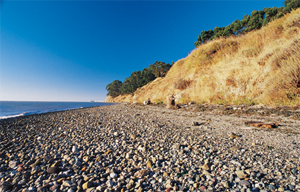
- Point Pinole is one of the few places where bluffs meet the Bay. Photo by Julia Thrower, www.naturesfootprints.com
For a dramatically different experience of the East Bay shoreline, I like to visit Point Pinole, a natural promontory at the tip of Richmond in Contra Costa County. When it was acquired in 1971, Point Pinole was under imminent threat of residential development. Instead, it became one of the district’s most critical purchases and its fifth shoreline park. Still the largest of the shoreline regional parks, it more than doubled EBRPD’s total shoreline acreage. The Hayward Fault runs along the south-western edge of the park. To the north is one of the few places where steep bluffs meet the Bay. These bluffs were created by erosion of ground uplifted, like the East Bay hills, along the fault. However, says soil scientist Glenn Borchardt, this section has undergone the slowest uplift in the Coast Range, allowing the Sacramento River to enter the Bay through the Carquinez Strait. Looking south toward Breuner (aka Parchester) Marsh from the Point, you see Giant Marsh in the foreground, tucked into the curve south of the Point, the lime-green marsh vegetation highlighted with splotches of orange marsh dodder (a parasitic plant). Historically, it was connected with Breuner Marsh to the south, explains Grossinger. “This whole side of the North Bay has these marshes—scalloped sections of shoreline—this repeating pattern of pocket marshes,” he adds. “They were important fishing sites for indigenous people.” Grossinger thinks harbor seals may have hauled out on the tiny beaches that have formed at the foot of the steep bluffs. Today, Giant Marsh is home to endangered clapper rails, harvest mice, and the mysterious and elusive black rail.
On the east side of the Point lies another exquisite marsh, known as Whittell. A trail takes you to the edge of the marsh where you can sit and watch the birds in relative solitude. Whittell Marsh, says Baye, is a “poor man’s China Camp.” In the spring the marsh is covered with goldfields, associated with vernal pools, and salt marsh owl’s clover. Farther upland, he says, Point Pinole displays some of the best remnants of native grasslands around the Bay. But in many of the upland areas, eucalyptus has taken over, displacing native plants but also sheltering monarch butterflies in winter. Grossinger thinks these “alien groves” would historically have been native grasslands, with some seeps and wet areas – meadows of native wildflowers and grasses. It’s hard to imagine, until I see songbirds flitting across the fields (albeit fields of yellow star thistle) accompanied by a jackrabbit. Although the birds may be eating the seeds of nonnative grasses, these same species—plus other, no-longer-common grassland birds—probably once thrived on the seeds of the native grasses and wildflowers that covered the Point. The seeds were also a staple for Native Americans. “‘Pinole’ refers to the gruel made from the grains and grass seeds,” Grossinger explains. “It was sweet, yellow gruel or ‘pinole’ from grass seeds or chocolate-colored pinole made from cattails.”
What is so impressive about Point Pinole is that despite its nonnative habitats, it offers a complete slice of Bay ecosystem. “Point Pinole is a microcosm,” says Grossinger. “It’s compressed—within 500 to 1,000 feet you can go from rolling grasslands to tidal marsh to beach to mudflat to Bay waters. You rarely see that intact nowadays—it’s usually spread out over a mile or so, but here you can see it all.” As Baye puts it, Point Pinole is “a window into the Bay of the past.” Native American residents of the Huchiun (Ohlone) tribe hunted and fished here, probably near the northeast corner of the Point, in Whittell Marsh, which, according to Grossinger, was likely rich in crabs, mussels, clams, oysters, and various species of fish, possibly even sturgeon.
But the Point has not had an entirely pastoral past. Like the Stege Marsh area along the Richmond shoreline near Point Isabel, another natural point, where the EBRPD manages the Bay Trail, Point Pinole was home to several explosives and gunpowder manufacturers. Between 1881 and 1960, two billion pounds of dynamite were manufactured here. In 1881, the first of the explosives companies, Safety Nitro Powder, established itself on the northern shore of Point Pinole. The legacy of one company, Giant Powder, is evident today in the name of Giant Highway—which takes you to Point Pinole—and Giant Marsh, just to the south.
As I walk the Point with EBRPD naturalist Dave Zuckermann, he shows me the remnants of some of the earthen and concrete bunkers built by the explosives manufacturers to try to contain possible explosions. Giant Powder Company, Zuckermann tells me, moved here after the public became outraged when plants in San Francisco’s Mission District, others near Golden Gate Park, and still more in west Berkeley (now Golden Gate Fields) had serious explosions. Giant built its own company town complete with a railroad station, school, bungalows, boarding houses, a park with a dance hall, saloon, and barbecue pits. Zuckermann shows me the shell of a concrete block building where nitroglycerine was mixed. After it was mixed and neutralized, it was delivered by small buggies—called “angel buggies” because their cargo could explode and the workers pushing them could be killed, instantly becoming “angels”—to a dynamite mixing house. From brick storage magazines near the Point, the explosives were taken by barge to big ships anchored off of Angel Island. It was the powder companies that planted the eucalyptus forest here, says Zuckermann, with the idea that the trees would help absorb any blasts.
Heading north along the Bay View Trail, buffeted by strong winds off the Bay and the invigorating smell of eucalyptus and the sulfur smell of marsh, I gaze at a south-facing slope that boasts a lush chaparral community – buckeye, coyote bush, toyon, sagebrush, and poison oak. This is one spot that probably looks much the same as it has for centuries. I head inland and back to the parking lot via “Owl Alley,” a eucalyptus-shaded path. Are there really owls at Point Pinole? Park Supervisor John Hitchen says great horned, barn, and other owls have been seen here. As if in confirmation, a large raptor launches itself suddenly from a eucalyptus. It turns out to be a red-tailed hawk, not an owl, but the sight is thrilling anyway. A train blares by, and shots from the Richmond Rod and Gun Club remind me of the park’s more explosive past. Yet if it hadn’t been for the powder companies, Point Pinole might have been developed long ago. “We like to say that Point Pinole was the park preserved by dynamite,” says Zuckermann.
Many of the Park District’s shoreline properties have been “saved” by similar human activities. The railroad tracks put down in the late 1800s along the East Bay shoreline act as levees, blocking full tidal flows to the marshes behind them to their east and creating what Grossinger calls the “behind habitats,” the muted tidal marshes seen from the Bay Trail. Though some of these places, like parts of Breuner Marsh, remain threatened by development, many are thriving today, perhaps because they were too much trouble to fill or too close to the tracks. In places like these, whether saved by intention or serendipity, we can connect with the Bay, visualize its past, and experience that enticing zone where water meets sand, mudflat, marsh, or bluff.