Up until recently, there were limited and fairly antiquated options on how to measure California’s snowpack. You’d either have a skier or snow shoer racing around to a bunch of monitoring stations, or embedded snow pillows would make measurements by sensing the pressure and water content of a layer of snow. Detecting groundwater was just as tedious, based on drilling into aquifers.
But California’s hydrological picture has gotten a whole lot clearer in recent years, and just in time to measure the impact of the current drought, thanks to the advent of new sky borne technology. When NASA scientists announced last month that the state was in a water deficit of 11 trillion gallons of water, enough to fill Lake Mead, it was the first-ever calculation of its kind, and based on data generated from satellites and fixed-wing aircraft.
The scientists are trying to answer the most basic questions that we need to know in order to understand our current climate predicament and plan for the future — when does a drought begin, and when does it end?
“We are now beginning to be able to answer the question of how much water will it take to end the drought,” says Jay Famiglietti,a hydrologist and senior water scientist at NASA’s Jet Propulsion Laboratory, who was talking to meteorologists earlier this week on a webcast hosted by Climate Central, a nonprofit news site that covers climate news.
In 2002, NASA launched the GRACE mission (Gravity Recovery and Climate Experiment), by launching two satellites to determine slight variations in the planet’s gravitational field. The maps that GRACE data generate show which areas of the planet are gaining or losing water each month, and a closeup of California shows just how bad it has been since 2012. (The GRACE mission is also monitoring the melting of the Greenland and Antarctic ice sheets.)

Two-thirds of California’s water losses have come from groundwater sources in the Central Valley, mainly from farmers offsetting surface water reductions, Famiglietti says. The satellites capture all sources of water — snowpack, groundwater, surface water and soil moisture. Apparently, this is the only satellite system that can make measurements of water below the first few centimeters of soil.
“We’re looking at the ups and downs of the wet season and the dry season and the emerging trends of total water storage as one integrated measure of all the water together,” says Famiglietti.
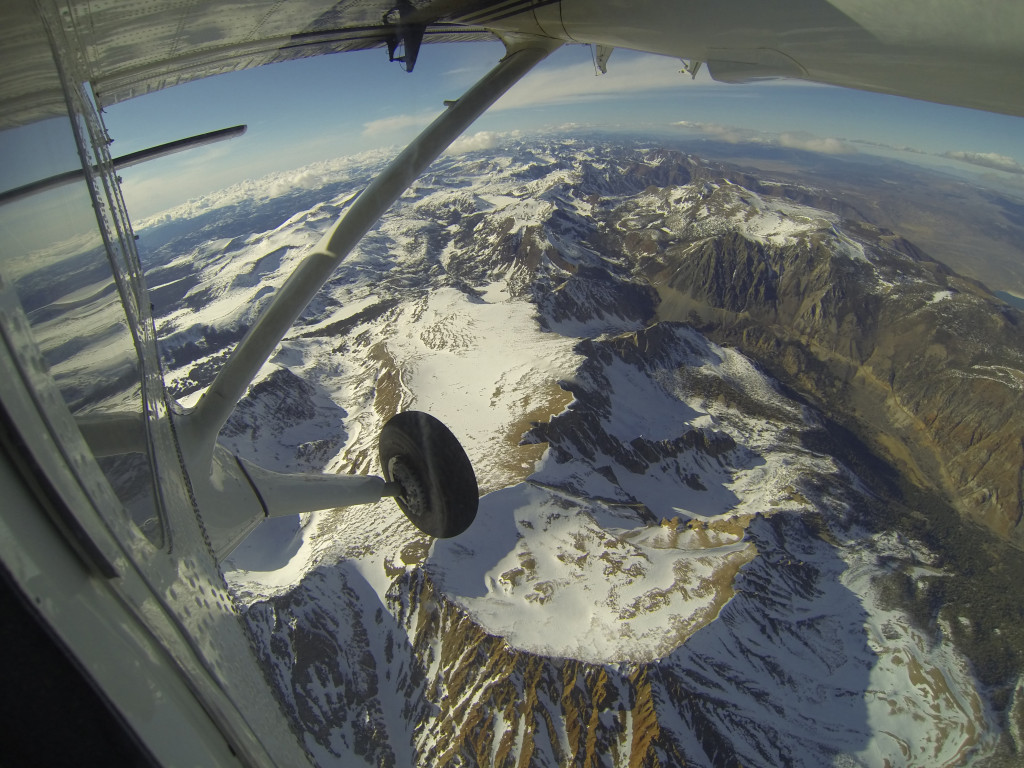
Another technological leg up has been the Airborne Snow Observatory (ASO), whereby fixed-wing aircraft are flown over the Tuolumne River Basin in the Sierra Mountains to measure the size of the snowpack — which is California’s hydrological lifeline during the long dry season. The aircraft are outfitted with imaging spectrometers to measure surface reflectance (the more reflectivity, known as albedo, the more area covered by snow) and with lidar, a remote sensing device that emits a laser and observes how the beam is reflected, indicating snow depth. With repeated measurements, scientists can track changes in snow depth over time. (You can even track live flights). ASO is funded by NASA sources and the California Department of Water Resources.
The ASO is capturing the spatial coverage of the snowpack by a factor of 39 million over traditional methods. Interestingly enough, the data is showing there’s a whole lot less of the snowpack than previously thought.
“Traditional measurements have been off by almost a factor of two, especially at higher elevations,” says Famiglietti. “Errors increase as you go to higher elevations, which makes sense. It’s logistically difficult to make measurements at higher elevations.”
We’re halfway through the 2014-2015 wet season, and despite the torrential December rains it’s looking like this may turn into another bad drought year. January has been the driest on record, and a high pressure ridge has formed again, as it did in the few years, blocking major rainstorms from hitting California shores. Based on the water deficit measurements, NASA scientists say we’ll need three years of above average precipitation to satisfy the storage deficit. Many scientists think it’s unlikely that will happen, especially the way this January is shaping up, raising the possibility of a protracted drought.
“I don’t think it looks too good for us,” says Famiglietti, who lives in Pasadena. “It doesn’t take too much to throw us off our game. We use more than we get each year from rainfall and imports from the Colorado River basin. That’s why even small changes have a huge impact.”
In the meantime, the data is pointing to a future with little water. During droughts, Californians typically rely on groundwater, and currently about 70 percent of the state’s water use is coming from aquifers, he says. That groundwater will eventually need to be replaced. And because of higher average temperatures (2014 was the hottest year on record in California), the precipitation we do get is often falling as rain in the Sierras.
“The combination of less rainfall and less falling as snow is going to be a huge problem for us in California because our reservoir system is designed to capture snowmelt after the winter,” he says. “Even if there were the same amount of liquid precipitation, we probably wouldn’t be able to capture it.