.jpg)
Tucked into the golden northwestern foothills of Mount Diablo, the Carquinez Strait comes as a watery surprise. Its blue waters twist like a snake between the steep bluffs of northern Contra Costa County and southern Solano County. Its western edge balloons into shallow San Pablo Bay, while its eastern end frays into the Sacramento and San Joaquin rivers. Through its eight-mile-long channel pours the collected power of streams from Shasta to Bakersfield; it drains a watershed that encompasses an astounding 40 percent of California, some 62,500 square miles.
The conduit of the Carquinez links the state’s inland breadbasket with San Francisco Bay and the Pacific Ocean. Deep waters and a prime location once made it an international shipping port second only to San Francisco itself. Today, the strait’s ruined piers and deserted railroad tracks mark two centuries of change—from bucolic ranch land to center of international commerce, and back again. “It’s a great example of different chapters of California history,” says Dave Zuckermann, supervising naturalist with the East Bay Regional Park District (EBRPD).
A look at the strait’s weathered stone walls and broad channel suggests this is an ancient feature of the landscape. But in geologic time, the Carquinez may have surprisingly recent origins. “The walls of the cliffs are steep and straight; they look geologically young, as if a giant had taken a knife and cut a slice out of the land,” says Andrei Sarna-Wojcicki, geologist emeritus with the U.S. Geological Survey. By piecing together evidence from the area’s sediments and rocks and the shape of the surrounding landscape, he concludes the strait was born in a violent flood of cataclysmic proportions.
The story begins about 700,000 years ago, in a California almost unrecognizable to modern eyes. Much of the Sierra was frozen in the grip of glaciers that were carving out Yosemite Valley. So much water was locked up as ice and snow that the oceans were as much as 400 feet lower than today. San Francisco Bay was a broad valley of forest and grassland. Deer-size early horses and herds of antelope grazed the coastal plains that stretched past what are now the Farallon Islands. Much of the San Joaquin Valley and part of the Sacramento Valley lay beneath the waters of now-extinct Lake Corcoran.
Scientists know of this lake from the thick layer of clay and freshwater snail and clam shells it left beneath the San Joaquin Valley. Aquatic fossils and other evidence prove that the lake’s waters emptied into the Pacific near Monterey Bay. About 650,000 years ago, the planet began to thaw, and great sheets of meltwater sluiced down the Sierra foothills. Runoff from across Northern California pooled in Lake Corcoran, driving water levels ever higher. Given the rate of melting, Sarna-Wojcicki believes that the lake may have extended into the Sacramento Valley, creating an inland sea that would have rivaled Lake Michigan in size.
At first, the excess water continued to empty into the ocean at Monterey. But since the earth beneath California is ever-restless, tectonic plate movements eventually uplifted the southeastern Coast Ranges high enough to plug the lake’s outlet. About 620,000 years ago, the lake finally spilled out of the next lowest point—the earthen sill between modern-day Crockett and Benicia. The wall of water likely blasted through the sill like boiling water through ice. The first trickles of lake water would have exploded into a thundering cascade briefly rivaling Niagara Falls. Eventually, it cut down to the channel bedrock 100 feet below today’s sea level. The breach of the Carquinez was the great lake’s death knell; once the channel was formed, that much water could never accumulate again in the Great Valley.
A few important pieces of this puzzle remain to be found. Some scientists think the lake may have cut through the Carquinez sill much more slowly, at the same rate as the Coast Ranges uplifted. Geologists can’t nail down the story for sure until more research is done on the age and distribution of Lake Corcoran sediments and shorelines.
Today’s strait serves as a link between two very different ecosystems—the coast and the valley. Nowhere is this clearer than in the strait’s curious mix of native plants. Botanist Dean Kelch, formerly with UC Berkeley’s University and Jepson Herbaria, is assembling a list of plants found in and around the strait. Because 95 percent of the area is covered by common grassland, coastal scrub, and oak and evergreen woodland habitat, Kelch didn’t expect to find many unusual species. “But the area has turned out to be a lot richer than I thought; I just had to look for it,” he says. In the three years he’s been working on the project, he and UC Berkeley graduate student Andrew Murdoch have tallied 740 species and counting.
What’s striking is the large number of species growing at the extreme edge of their range. Take yellow bush lupine, for example. It’s common along coastal dunes and headlands, but the farthest inland it has been found is at the base of the new Al Zampa Bridge, which connects Crockett to Vallejo. Meanwhile, Clarkia biloba, a wildflower, and locoweed, a low-growing legume, have traveled from the east. The clarkia is normally found in the Sierra foothills, while locoweed (Astragalus asymmetricus), with its handsome silver leaves, hails from the Central Valley.

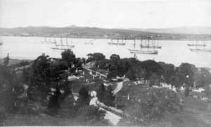
- In the late 1800s, Carquinez Strait ports hosted a surprisinglylarge wheat trade. Ships like these (shown off Martinez in the 1890s)carried grain to markets as far away as England. Photo courtesy Contra Costa County Historical Society.
Their presence along the strait is no accident. Because the Carquinez straddles both the sunbaked grasslands of the Great Valley and the fog-swathed coast, its corrugated hills host an astonishing array of microclimates. Ocean breezes moderate inland temperatures that would otherwise swing between freezer and furnace. At the same time, Kelch says, “the strait as a geographic feature functions as a corridor for plants and animals to migrate east and west. This big break in the Coast Range allows lowland creatures to get through very easily.”
The unusual mix of plants survives largely because of the extraordinary expanse of open space that remains along the strait. The East Bay Regional Park District alone has set aside nearly 3,500 acres of parkland on the strait’s southern shore—a key to district efforts since the late 1960s to open 47 miles of public shoreline in the East Bay. Much of the other open space near the strait is owned by the nonprofit Muir Heritage Land Trust and working ranchers.
The tumultuous changes that have taken place along the strait over the last two centuries are encapsulated by the story of Crockett Hills Regional Park. Just opened to the public this past June, the 1,300-acre parcel was once a hunting ground for two Ohlone-speaking tribelets—the Huichun and Karkin (whose name graces the strait today). For thousands of years, they ventured into the strait on leaf-shaped tule reed boats to fish for salmon and sturgeon. They hunted deer and other animals in shoreside canyons, and harvested seeds and plants from the grasslands and forests. The arrival of Europeans in the 1770s, however, cut their tenure tragically short. Within 25 years, the land had passed into Mexican control.
In 1843, the governor of Mexico granted the entire southern shore of the strait, including the Crockett Hills, to one Teodora de Soto. Her property, Rancho Cañada del Hambre y las Bolsas, encompassed the area from modern-day Crockett to Martinez. Señora de Soto, like neighbors Ygnacio Martinez and General Mariano Vallejo, ran Spanish longhorn cattle on the steep, dry hills. Each year, the ranchos shipped thousands of pounds of hides and tallow by schooner to New England to be manufactured into shoes, soap, and candles.
The era of the great ranchos would prove short-lived. In 1848, Mexico ceded its northern territories to the United States. California’s Mexican citizens were compelled to defend their property rights in U.S. court. Land-rich but cash-poor, many paid their attorneys in property. Among them was de Soto, who settled her debts with lawyer Joseph Crockett with 1,800 acres near the western edge of the strait.
Statehood and the Gold Rush brought a new kind of flood to the Carquinez—Americans. Would-be miners, adventurers, and entrepreneurs sailed up the strait toward Sacramento and the goldfields, creating changes nearly as startling as the breach of the strait half a million years earlier.
Though ranching continued in the hills, the shoreline was quickly transformed into an industrial port. By the 1870s, California’s new settlers were producing more than 25 million bushels of wheat per year in the Bay Area and Central Valley, three-fifths of it destined for export. The logical route for moving it was through the Carquinez Strait, so the waterway became a hub of agricultural processing and transport.
“The area may look sleepy now,” says EBRPD’s Zuckermann, “but, in the 1880s and ’90s, it was the happening place. Brothels and saloons stretched from Eckley to Port Costa.” In the late 1870s, the Central Pacific Railroad laid track along the strait’s southern shore to speed grain delivery from inland farms, and trains up to 32 cars long were disassembled daily to cross the strait on the world’s largest ferry, the paddle wheeler Solano. Cavernous warehouses and silos housed the wheat at water’s edge until it could be loaded on ships bound for Europe and South America. (The ghostly remnants of the wheat boom—rotting wharf pilings and empty grain warehouses—can still be seen at Eckley Pier, now part of the Carquinez Strait Regional Shoreline.)
Amid the grain vessels on the strait bobbed the boats of immigrant fishermen. Italians, Portuguese, and Greeks netted salmon migrating from the ocean to spawning grounds upriver. In an age before refrigeration, much of their catch wound up in the maws of straitside canneries. Tins of salmon, oysters, and shad were shipped worldwide.
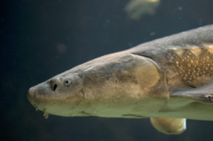
Those marketable fish and bivalves are just a few of the many aquatic species, from endangered Delta smelt to migrating waterfowl, that gather in this narrow mixing zone of fresh and salt water. Lighter freshwater flows westward at the surface; heavier saltwater flows eastward along the bottom. Where salinity is greatest, dissolved sediments tend to drop to the bottom, carrying algal phytoplankton with them. There, the saltwater current pushes them back upstream, concentrating nutrients in the strait.
Blessed with a deepwater port, Crockett prospered. First came the Starr Flour Mill in 1887. When overseas competition undercut California’s wheat market in 1900, the building’s square brick and mortar bones briefly became a beet sugar factory. Then in 1903, the California & Hawaiian Sugar Company bought what remained of the old Crockett parcel. The factory, the town of Crockett, and the hills behind became company property. Cargo ships disgorged tons of raw cane from Hawaii and departed with holds bursting with bags of snow-white sugar—a cycle that continues to this day.
And the rugged hills that de Soto ranched not so long ago? Over the 20th century, a succession of three ranchers leased the property to raise cattle. Some of their handiwork can be seen today just past the Crockett Hills parking area. The dairy barn, with its gabled peak, side bays, and hayloft (circa 1900), is one of the last of its kind in Contra Costa County.
A trek up the park’s steep main trail delivers more dividends. On a clear day, the ridgeline of Crockett Hills Regional Park offers one of the most spectacular panoramas around. Many of the region’s most distinctive landmarks—Mount Diablo, Mount Tamalpais, the San Francisco skyline, and the Golden Gate—can be seen from this newest six-mile section of the Bay Area Ridge Trail. To the north lies an equally spectacular vista: the strait overlook and the Al Zampa Bridge. Above, golden eagles, turkey vultures, and other raptors patrol the rolling grasslands for voles and ground squirrels. Gray foxes and coyotes haunt the steep, narrow canyons thick with live oak and bay laurel.
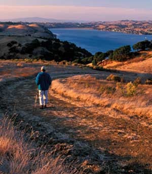
- The trails of the shoreline parks near Crockett and Martinez providepanoramic views of the Delta, the Bay, and the hills of Solano, Sonoma,and Napa counties. Photo by John Karachewski.
A week after the opening of Crockett Hills, the Muir Heritage Land Trust celebrated the acquisition of another huge nearby parcel of land destined to become public open space—702-acre Fernandez Ranch, just south of Highway 4. Strategically located between the southern edge of Crockett Hills and the western flank of the Franklin Ridge, it is the linchpin in an ambitious plan to create an unprecedented corridor of preserves across Contra Costa County. The land trust already owns the Dutra, Sky, and Gustin ranches atop the ridge’s spine. If EBRPD and the land trust realize their plans, hikers will someday be able to travel all the way from the Carquinez Regional Shoreline to Mount Wanda in Martinez on one unbroken trail. The route would become part of the Bay Area Ridge Trail that, with luck, will someday traverse 500 miles of hilltops encircling San Francisco Bay.
Back at the Crockett Hills dairy barn, along the banks of Edwards Creek, a stand of skinny oak saplings has taken root. They were planted by the teen interns of the Carquinez Regional Environmental Education Center, or CREEC. The students helped collect acorns within the park, nurtured all 200 seedlings, and planted them this past winter. The tiny greenhouse where these trees were born is perched atop a hill by the main trailhead. Inside, the floor is covered with planter pots of Indian paintbrush, yarrow, buckeye, wood grass, coast live oak, wild strawberry, and other native greenery. Each is neatly labeled with the species and its site of origin—Edwards Canyon, Elkhorn, the Fifth Street Prairie.
“Our mission is to educate children while doing restoration projects,” says Sandra Dare, CREEC’s executive director and founder. “The goal is to have children feel ownership of the projects, to learn what’s native and why it grows where.”
Local parks and their plants could certainly use the help. After a century spent as rangeland, these hills are beset by exotic invaders such as yellow star thistle. CREEC’s planting projects replenish park ecosystems with locally adapted plants.
With the opening of Crockett Hills, CREEC has relocated most of its operations to Crockett itself, next door to the massive footings of the Carquinez Bridge. Thanks to Dare, her staff, and their young interns, the abandoned warehouses have given way to a shiny professional greenhouse. Around it, tables sag beneath the weight of dozens of carefully tended seedlings destined for the area’s now-plentiful preserved parkland. With EBRPD, the Muir Heritage Land Trust, and CREEC looking out for the habitat along the Carquinez Strait, the future of this pivotal waterway seems bright indeed.
Special thanks to Doris Sloan, Beverly Lane of EBRPD, and Beth Pardieck of Muir Heritage Land Trust.