After two years of negotiation with the East Bay Regional Park District (EBRPD), Chevron has agreed to allow access to two parcels of land on Chevron property that moves a step closer to extending the San Francisco Bay Trail along Richmond’s Point San Pablo Peninsula.
“With Chevron’s help, the Richmond community will have more trail access and future open space parkland along the waterfront, which has long been a part of the park district’s master plan,” said Bob Doyle, EBRPD’s assistant general manager for land acquisition.
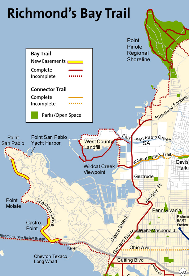
The easement donation consists of two segments totaling 1.5 miles: a southern segment from the foot of the Richmond–San Rafael Bridge that runs to the beach at the former U.S. Naval Fuel Depot at Point Molate, and a northern segment that runs north of the former depot, past Point Orient, and ends just south of Point San Pablo property owned by the City of Richmond.
“What Chevron is doing is not unusual,” commented Bruce Beyaert, chair of the Trails For Richmond Action Committee (TRAC), which formed 10 years ago to facilitate development of the trail. “Many sections of Bay Trail have been built on easements donated by private landowners. What is unusual is it’s a lot of land in a high profile area and that Chevron now is playing a positive role in helping complete the Bay Trail–we applaud that.”
However, there’s a lot more to be done to open the Bay Trail along the shoreline here. Before any new trail can be built on these Chevron easements, EBRPD has to secure railroad easements owned by Burlington Northern Santa Fe and Union Pacific. “Now that the Chevron agreement is in place,” says Beyeart, “the park district has the difficult challenge of dealing with not one but two railroads, which each own 50 percent of the easements.”
Though the two new easements are a big step forward, two additional easements on Chevron land are necessary to complete Richmond’s Bay Trail as planned: one between the City of Richmond’s Point San Pablo property and the Point San Pablo Yacht Harbor, and the other south of I-580 between the end of Tewksbury Street and the Richmond Bridge toll plaza.
The more controversial easement involves the Chevron land on the south side of I-580, a section necessary to provide safe pedestrian and bicycle access between Point Richmond and the existing trail under the bridge. Currently, there is no pedestrian access and bicyclists must pass over a short stretch of freeway and use winding exit ramps to access the Point San Pablo Peninsula. Trail advocates say this is a dangerous passage, and in 2006 a bicyclist was struck by a car and killed while crossing this section on the I-580 bike path. Although Chevron had previously refused to grant access to this parcel, citing concerns over security issues, company officials have recently agreed to consider access and are working with the City of Richmond, Caltrans, and the Association of Bay Area Governments on design studies.
Beyaert says the design will involve fairly complex trail support structures along 580 to connect to the existing passage under the bridge. That section of trail will cost about $13.5 million just for construction, and feasibility will hinge on another easement donation from Chevron. “The real test will come once the trail alignment has been agreed upon,” says Beyaert. “Then it’s hoped that Chevron will continue to cooperate and convey an easement for the project.”
The section of trail north of 580 is also bound up with controversial plans for a casino or other development at the former naval station at Point Molate. But trail access is guaranteed in that section by agreements between the developer, Upstream LLC, and the City of Richmond, which owns the property.
Richmond’s Bay Trail is part of the San Francisco Bay Trail project, a planned 500-mile shoreline trail that will encircle San Francisco and San Pablo Bays with a continuous network of bicycling and hiking trails. To date, 296 miles of the trail have been completed. The City of Richmond has 32 miles of shoreline, more than any other city on San Francisco or San Pablo Bay, and 26 miles of the Bay Trail are already in place.

.jpg)


-300x159.jpg)