In 1962, Harold Gilliam, dean of Bay Area environmental journalists and columnist for the San Francisco Chronicle, wrote the definitive Weather of the San Francisco Bay Region. Now Gilliam and University of California Press have issued a thoroughly updated version of this classic work. Following are excerpts from the book, arranged by Bay Nature to tell the story of the forces that produce the Bay Area’s signature climatic phenomenon—fog. (Reprinted by permission of University of California Press.)
In the San Francisco Bay Region, the characteristic summer fog is widely regarded as a boon and a blessing, bring the clean, salty aroma of the Pacific and keeping the days refreshingly cool as it advances from the ocean in fantastic flowing forms that from day to day are unique and unpredictable. Shaped by the slant of the California coastline and the oceanic currents of wind and water, by the presence of a strait and estuary penetrating the coastal mountain ranges, and by the hill-and-valley contours of San Francisco and the Bay Region, the advance of the summer fog inland from the Pacific is one of the planet’s most awesome natural spectacles.
A Unique Climate
The causes of this unique spectacle lie in California’s extraordinary geography. In general, the state has a Mediterranean climate, with mild, wet winters and dry summers. But that general type is locally modified by special features of the landscape. The Golden Gate is the only complete breach in the Coast Range, which borders the Pacific for most of California’s length. As a result, the Bay Region is the meeting place of continental and oceanic air masses. Through the funnel of the Golden Gate and San Francisco Bay, the immense aerial forces of sea and land wage a continual war, and the tide of battle often flows back and forth with regularity. The line between the two types of air masses, particularly in summer, may zigzag through the streets of San Francisco and extend in similarly erratic fashion across the entire region.
The reason for the zigzags is the complex topography of the Coast Range, which modifies the basic struggle between air masses of land and sea in intricate ways. In general, the Coast Range in this region is a double chain of mountains running north and south (or, more precisely, north-northwest and south-southeast). Between the two chains lies the basin of San Francisco Bay. North and east of the Bay, the range is further subdivided into subsidiary chains.
Eastward from the ocean, over the several ranges, each successive valley has less of a damp, seacoast climate and more of a dry, continental climate—hotter in summer and colder in winter. But this basic pattern is further modified and complicated by a number of gaps and passes in the ranges—the most important of which is the Golden Gate—that allow the easy penetration of seacoast weather inland.
The Pacific High
During March, April, and May, as the days grow longer, the northward-moving sun heats the continent day by day, melting mountain snows and causing flowers to bloom and fruit to bud across foothills and plains and deserts. In the Central Valley of California, a 500-mile-long basin surrounded by mountains, the heated air rises. Through a complicated interchange of pressure systems in the upper atmosphere, the result is falling pressure at ground level in the Valley. Weather Service forecasters mark the Valley on their maps with a large L for low pressure.
Out over the Pacific, air warmed by the hot sun over the Equator rises and heads northward toward the Arctic. Some of it cools off and sinks to the ocean surface several thousand miles to the north, where it becomes the Pacific High—a “mountain” of cool air weighing heavily on the water surface. Marked by a big H on the weather maps, the Pacific High usually occupies a position somewhere between San Francisco and the Hawaiian Islands. The result of this differing pressure is what the meteorologists call an “onshore pressure gradient.” Just as water tends to seek its own level, so air tends to equalize its pressure, moving horizontally from a high-pressure area to a low-pressure area, or from a cool to a warm zone. So in the Bay Region, the air rushes from the cool ocean toward the warming continent.
Ocean Upwelling
Like everything else moving on the surface of the earth, the winds coming from the Pacific High toward the continent are affected by the Coriolis force (a product of the rotation of the earth), which causes the wind—and the ocean currents borne along by it—to curve to the right (clockwise) across the surface. The northwest wind blowing down the California coast pushes the surface of the ocean before it and creates a strong current running southward down the shoreline like a river. Due to the Coriolis force, during the summer months the southward-moving current veers offshore. In order to replace the surface currents moving away from the coast, masses of water surge up from the bottom of the ocean, creating a continual fountain of upwelling waters.
This bottom water, coming from depths of several hundred feet, may be 10 to 15 degrees colder than the sun-warmed sea surface. Summer swimmers at Northern California beaches are painfully aware that these waters are frigid—often in the mid 50s—compared to the temperatures of the surf along the beaches of Southern California, which are beyond the principal zone of upwelling and frequently reach the 70s. In some areas where the upwelling is intense, the water in summer is colder than in winter, when the upwelling is minimal.
This streak of cold water along the coast is a basic part of the Bay Region’s summertime air-conditioning system. The wind from the northwest, skimming thousands of miles of ocean, absorbs great quantities of moisture that has evaporated from the surface. The moisture is suspended in the moving air as invisible vapor. When it approaches the coast, the air comes into contact with the cold, upwelled waters and is itself cooled off, causing its invisible vapor to condense into visible droplets. The droplets cling to the minute particles of salt that have been thrown into the air with the spray. As the wind blows over the cold surface, the drops continue to form until they create a haze, which soon thickens into fog. The same process that causes moisture to form on the outside of a glass of cold water takes place here on a mammoth scale.
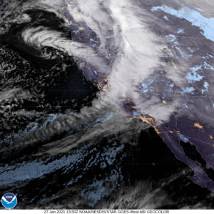
The Great Fog Bank
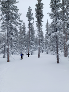
The result is the great fog bank that envelops most of the California coast intermittently during late spring and summer. It may range in width from a hundred yards to more than a hundred miles; in height, from a hundred feet to half a mile. In the beginning, however, it takes form merely as puffs and wisps of vapor that drift landward and cling to the shoreward slopes of the coastal hills or hang over the beaches. Then, as the season advances and the wind increases, the entire process accelerates; the separate vapors merge into a solid mass that steals up the coastal canyons in late afternoon or early evening when the sun’s rays are no longer strong enough to burn it off. In some of the canyons, it collects on the branches of the redwoods and drips to the ground, keeping the earth damp. The big trees thrive on this moisture. Redwood country is fog country; Sequoia sempervirens rarely grows naturally beyond the range of the sea fog.
Along most of the Coast Range, the sea air and its fog reach the heads of the canyons and are stopped by the higher ridges from penetrating farther inland. But at the Golden Gate, the only sea-level breach in the mountains, the wind moves through the range, bringing with it the masses of condensed moisture. At the maximum, an estimated million tons of water an hour float through the Gate as vapor and fog, enveloping the deck of the Golden Gate Bridge and swallowing ships and shores as it advances. But the fog itself is not the primary element at work. It is created by and borne upon the wind. When the wind is sufficiently laden with moisture and sufficiently cooled by the water, the fog comes into being and is carried inland by the moving air.
Fantastic fog forms may develop as the advancing white mass encounters obstacles. It may come in surges like a slow-motion surf, exploding into spray on the ridge at the north end of the Golden Gate Bridge, forming a standing wave over Sausalito, whirling horizontally in eddies around promontories, and pouring over Twin Peaks and the Peninsula hills, where it forms fog falls and fog cascades down the leeward slopes. If it comes in low on the Bay surface, it is likely to billow in domes over Alcatraz and Angel islands. At times a fog deck will appear part way up the Berkeley Hills and build out toward the Bay.
The Fog Cycle
Week by week from spring into August, the forces that produce the fog increase in intensity. The Pacific High moves farther north, closer to the latitude of San Francisco, sending out stronger winds; offshore the up-welling of cold bottom waters increases, condensing the winds’ moisture into thicker masses of fog; in the Central Valley, the northward-moving sun sends temperatures to the 100 degree mark and beyond. The hot air rises, sucking cool masses in great drafts through the only break in the Valley’s surrounding mountains, San Francisco Bay. With the ocean air comes the fog, evaporating gradually in the hot, dry air of the Valley, but sometimes penetrating at night as far as Sacramento and Stockton.
The fog seems to come and go in cycles. Until recent years, the conventional explanation for the fog’s behavior was a simple one: as the cool, fog-bearing ocean air is pulled over the coastal hills and across the Bay toward the hot Central Valley (that is, from a high-pressure to a low-pressure area), the nearest parts of the Valley begin to cool off after a few days, much as a draft from an open door lowers the temperature in a warm room.
The incoming cool, heavy sea air replaces the warm, rising land air, and temperatures in Sacramento and Stockton may drop from well above 100 degrees to the “cool” 90s. When the Valley cools sufficiently, the fog-producing machinery breaks down. Without the intense Valley heat to draw the sea air in through the Bay Region, the wind diminishes and no longer carries the fog inland. San Francisco, the Golden Gate, and the coastline are fog free
Then the process starts all over again. Without the incoming wind and fog, the sun gradually reheats the Valley. The rising warm air again begins to attract the foggy marine air inland. The result is a fog cycle of about a week in length, producing roughly three or four days of fog over the Bay and three or four days of sun.
However, the foggy or sunny spells sometimes persist for weeks, with no apparent cyclic regularity. With increasing knowledge of the workings of the upper atmosphere, meteor-ologists have learned that although the fog penetration is related to the alternate heating and cooling of the Central Valley, it is also influenced by much larger forces in the global weather picture, such as changes in the jet streams that encircle the globe.
Usually, however, the delicate balance of forces governing the Bay Region’s weather is maintained, giving the area, at the gateway between the land and the sea, its incomparable combination of continental and maritime climates, dryness and dampness, sun and fog, heat and cold.