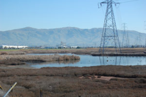
It was the kind of January day where you couldn’t see your breath but the baylands were steaming. Puffs of smoke garlanded the spires of bordering oil refineries. Blue skies, green hills, white windmills, and three bridges marked the corner of my eye. With so much to look at, it was hard to focus on the precise place here along the Contra Costa County shoreline east of Martinez where 12-mile-long Walnut Creek empties into Suisun Bay. That day the moon intervened on my behalf—conjuring a king tide that flooded the low wide channel with so much water that the creek mouth emerged in plain sight. The scene even proffered the bark of sea lions from a channel buoy, a passing ship, and a raptor. Spreading its black-tipped wings, this muscular harrier flew a wavy line across a run-down marsh as he scouted for snacks. The sight reminded me that wildlife doesn’t have to be in a wilderness to thrive. Everything about this landscape has the makings of the kind of resilience our former creek mouths may offer as we reconstruct our shores to adapt to rising sea levels.
More than 200 creeks once flowed toward the Bay—either cutting a direct channel to the shore, or melding into a marsh slough, or spreading into a moist meadow before percolating into the groundwater basin, among many pathways. Today, however, most of these creeks aren’t allowed to follow their nature. Farmers dug them into ditches and erased them from their fields; salt-makers rerouted them around their bayshore production ponds; and growing towns confined them to culverts, tunnels, and channels. Nobody likes to find their property swamped after a storm.
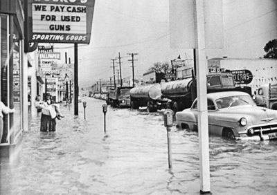
By the mid-1900s, the big alterations were being made by the U.S. Army Corps of Engineers and the small ones by local public works departments and flood control districts. Engineers often designed these systems to accommodate the kinds of floods that occur once every 100 years. But then along came climate change and the prospect of “100-year” floods occurring much more frequently. And along with that came fears of flooding threatening us from both above and below—as the first flush of storms surging down creeks might meet the higher tides of a rising Bay in the lower elevations of many a Bay Area town.
“In 2006, we had a flood that was so bad that in order to protect downtown Novato we were put in the position of having to breach a levee or the levee was going to breach itself,” says Liz Lewis, watershed planner for the Marin County Department of Public Works. The situation forced the county to move a little faster than planned with some ideas it was already considering for the future. “We breached the levee, diverted some flows into a basin, and let 1,200 acres of our property flood, and the floodwaters downtown receded. It was a ‘wow’ moment. We started to see how opportunities watershed-wide really needed to be pulled together so we would have a strategy not just to protect us from storms like 2006, but also from sea level rise.”
Pulling it all together is one of the goals of Flood Control 2.0, a planning partnership of the San Francisco Estuary Partnership, the San Francisco Estuary Institute (SFEI), the San Francisco Bay Joint Venture, and the Bay Conservation and Development Commission (BCDC). Novato and Walnut Creek are two of the project’s natural laboratories for experimentation. Maybe there’s a way for flood control to be less rigid and more flexible. Maybe the way California creeks used to behave naturally could teach us a thing or two.
“We have some pretty progressive flood control agencies around the Bay who have heard from their local citizenry that they would like to see the next generation of flood protection projects be more green and support more fish and birds and marshes,” says Robin Grossinger, an historical ecologist with SFEI who heads up Flood Control 2.0’s science team. “The truth is, creek mouths are a critical part of the Bay edge that have been incredibly neglected and incredibly modified. Restoring them offers a whole new frontier for ecological resilience.”
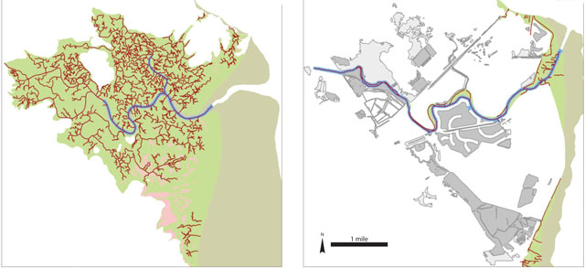
I asked around about whether there were any good examples left of a natural creek mouth on the shores of San Francisco Bay. Nobody seemed to have an answer. But we have a rough idea of how they behaved in the past. SFEI geomorphologist Scott Dusterhoff, who led the development of an online tool for comparing historic to present-day creeks for Flood Control 2.0, says his team noticed two “illuminating things right off the bat.” First, a lot of creeks were just plain gone. Second, many of the creeks that did not historically connect to the Bay, except during the biggest flow events, now have a permanent connection — courtesy of human intervention.
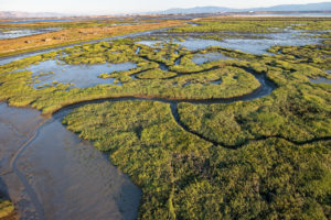
Where creeks did reach the Bay, says Grossinger, they once had “little mini-deltas or estuaries with more sediment coming out of the watershed, more freshwater influence, and a more complex interface with terrestrial and riparian habitats, than what we see today.” Flood Control 2.0 would like to rework some of this natural adaptability into the areas around former creek mouths.
Walnut Creek
Walnut Creek flows out of the west side of Mount Diablo, picking up water from a number of medium-size tributaries as it streams north through the towns of Concord and Walnut Creek and then meets up with Pacheco Creek before flowing out into Suisun Bay. In the mid-1900s farmers wanted the creek’s floodplain for farming, and they gradually started to turn its lower reaches into more predictable channels. After major floods in the 1950s and 1960s inundated the growing towns around the creek, the Army Corps took over, widening and deepening the lower channel and rimming it with walls.
Eventually however, sediment piled up in the channel, making it less effective for flood control but friendlier to plants and animals that rely on riparian and floodplain habitat. The Army Corps removed 850,000 cubic yards of sediment in 1973, but by the 1990s it was back again and so was the muddy habitat. The corps said that the sediment (and the habitat) had to go.
“From a geeky engineering standpoint, the channel had already come into equilibrium in terms of sediment balance. If we had removed it, I was worried it might throw the creek out of balance and it would take decades to get the habitat back,” says engineer Paul Detjens, who started his career at the corps but has worked for the Contra Costa County Flood Control District for more than 20 years.
Initially, instead of more dredging, Contra Costa partnered with the corps on restoration planning but that process foundered. “We were stuck with a corps partner that lacked funds to finish planning but still demanded we remove sediment so the channel could look like the one they built in 1965,” Detjens says. Finally, in 2014, with the help of Congressman Mike Thompson, Contra Costa succeeded in doing something fairly unheard of — removing a flood control channel from federal control. As a result, the district will no longer have to dredge sediment from the lower four miles of the watershed, and will instead have a natural supply of the precious material for restoration around the mouth of the creek.
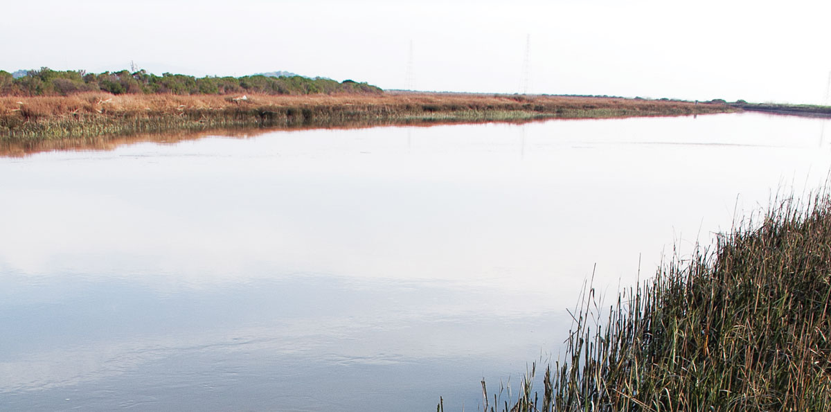
Looking over the scene where Walnut Creek flows into the Bay, one can readily see how Detjens hopes to recover a lot in this potentially dynamic zone. Amid the sewage pipeline risers, fenced-off landfills, and Homeland Security–patrolled refinery perimeters, he points out where there’s wiggle room to spill into old floodplains, widen the west side of the flood control channel, and improve adjacent Pacheco Marsh. And while he’s at it, he’d also like to provide a couple of points of public access to an otherwise private shoreline.
First steps will be an analysis of what elements of the built landscape — roads, refinery environs, bridges, sewage lines, industrial yards — could be at risk from flooding and sea level rise. The analysis will be carried out by the BCDC’s Adapting to Rising Tides team. After that, Flood Control 2.0’s science and design team will collaborate with the flood control district and the community at large on a new plan. “Our district represents the next generation in flood management. We’ve turned a corner, and we now have a much more sustainable mindset of working with nature,” says Detjens.
Novato Creek
According to a review of old maps, descriptions, and photographs, Novato Creek once drained into a mosaic of estuarine habitats encompassing more than 8,000 acres. Habitats within this zone included a big band of tidal marsh, 98 miles of tidal channels and sloughs, and over 20 miles of the kind of transition zones between water and land so necessary for habitats and creatures to adapt to high tides and higher seas. But when humans confined the creek between levees and turned adjacent baylands into farm fields, the creek mouth lost more than 80 percent of this estuarine habitat, including its marshes, channels, and transition zones. Sediment started clogging the main channel, resulting in the need to dredge 30,000 to 50,000 cubic yards every four years, while the drained baylands lost their sponginess and sank three to four feet below sea level.
By the time the 2006 flood came along, Marin County had already increased the capacity of an upstream reservoir and feeder creeks and was well on the way to reevaluating its flood control infrastructure with habitat and sea level rise in mind, via its Novato Watershed Program. Communities along the creek were very supportive. And Novato’s flood control district had one big rabbit up its sleeve that few others could conjure: 1,200 acres of its own land. “We have this huge blank slate to work with, which is unique in the Bay Area,” says planner Liz Lewis. “It’s one of the reasons Flood Control 2.0 represented such a great opportunity for us when it came along in 2012. It was the perfect time to support and enhance our planning process.”
Through a couple of design workshops bringing together local flood control engineers and the expert regional science team coordinated by SFEI, the group has now penciled out a long-term vision for the lower reach of Novato Creek and identified high-priority areas for making it more adaptable to sea level rise. In one area north of Highway 37 and west of Highway 101, for example, the plan proposes to redirect fine sediment clogging the upper creek channel onto the marshes via slurry. Adding this layer will help the marsh plain rise in elevation, in keeping with the rising level of the Bay.
Another idea is to reuse highly treated wastewater from a local sanitary treatment plant to irrigate plantings on the side of a new kind of “horizontal” levee, akin to using a treatment wetland instead of discharging wastewater to the Bay. In an ongoing drought tapping treated wastewater for restoration irrigation seems like a no-brainer. Meanwhile, the new levee, built a little wider to provide habitat for animals seeking refuge from high tides, could protect infrastructure, help endangered species, and treat nutrients in the wastewater. Novato residents will get a chance to hear about this vision in a public workshop this spring.
“It’s a pretty cool collaboration,” Grossinger says. “It’s a lot to ask local agencies to think in terms of Bay habitats as a whole.”
The vision proposes to reconnect the creek to the adjacent marsh and recreate historic salt pans favored by several bird species. It even suggests in-your-wildest-wetland-dreams items like a flow-through causeway for Highway 37. If Bay tides could spread farther west into former marshlands, for example, by passing under the highway, it might relieve some of the flooding pressure in northern Marin.
“Flood Control 2.0 is not advocating over-engineering of these landscapes,” says Dusterhoff. “In the areas where Marin County has the potential of getting land next to the creek, that’s where we call for taking down levees and letting tidal action come back in. In other areas, where we know Marin County can’t change the flood control infrastructure because it protects development and transportation corridors, that’s where we proposed the horizontal levee.”
Walnut Creek isn’t as far along in the Flood Control 2.0 planning process as Novato Creek, but enthusiasm for the possibilities among planners and the local citizenry is already equally palpable.
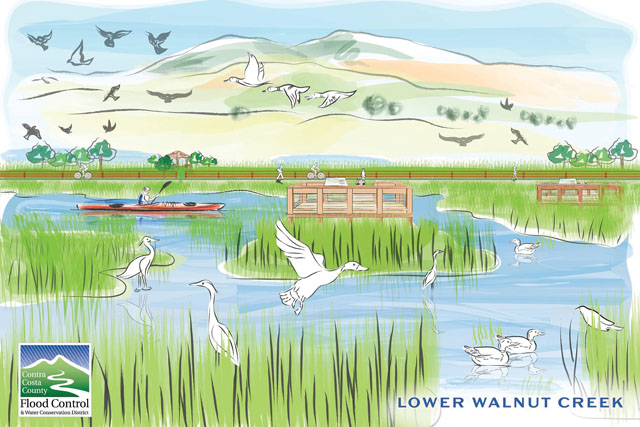
Local photographer Steve Hutchcraft has visited the nation’s greatest wildlife refuges and thinks Walnut Creek’s shoreline zone could be a “world-class” addition to their ranks. “The combo of salt marsh and creek mouth means the area now hosts one of the most elusive bird species in the country, the black rail,” he says, recalling a visit to the site when a biologist broadcast this tiny red-eyed bird’s call and got three birds to call back within five minutes. “They’re very territorial,” he says.
Hutchcraft is also on the board of the Muir Heritage Land Trust, a nonprofit involved in efforts to improve the ecology of Pacheco Marsh on the banks of the Walnut Creek flood control channel. On a recent tour with elected and local officials, he emphasized that birding is a $41 billion industry, according to the U.S. Fish and Wildlife Service, and that Pacheco is the perfect place to enjoy it.
“There’s low spots and high spots, lots of waterfowl during migrations, raptors and owls, song sparrows and yellowthroats,” he says. “The lighting is really good; nothing blocks the views. You’ve got the sun coming up over the Delta and setting over the Carquinez Strait. Opportunities for photography and nature study abound.” And so, it would seem, do opportunities for something as seemingly mundane as flood control.
Support for coverage of climate change and sea level rise provided by Google, Inc. and Bay Nature donors.