The Scripps Institution of Oceanography in La Jolla, California has long been a leader in studying the weather phenomenon known as El Niño. In a recent Scripps video a handful of scientists recount the story of El Niño forecasting by remembering that the strong El Niño of 1982-83 was a complete surprise, catching unaware not just the scientists but also the state’s emergency services. Never again, they said, and when they saw a strong El Niño taking shape in 1997-98, they sounded the alarm early.
Remember, they are an exotic species in the Western United States, and are rapidly increasing their geographic range and range of habitats. Are they outcompeting or excluding native species in the process? How would we know? We have done almost nothing to monitor changes in the assemblage of mushroom species in areas before and and after the incursion of death caps.
Further Reading
Pringle et al, “The ectomycorrhizal fungus Amanita phalloides was introduced and is expanding its range on the west coast of North America,” Molecular Biology 2009
Lockhart et al, “Simultaneous emergence of multidrug-resistant Candida auris on 3 continents confirmed by whole-genome sequencing and epidemiological analyses,” Clinical Infectious Diseases 2017
Battalani et al, “Aflatoxin B1 contamination in maize in Europe increases due to climate change,” Scientific Reports 2016
El Niño: Beyond the Hype

Bay Nature goes beyond the headlines to explore what the strongest El Niño in recorded history might mean — or not — for Northern California. We’ll post new articles here throughout the fall and winter.
This series has been funded by donations from Bay Nature readers. Please help us by sharing our work, or donate today to support our mission to explore the natural world of the Bay Area.
But to their embarrassment nothing seemed to happen. November was dry, December even drier. In late January, though, a series of non-stop storms started pummeling California, with copious rainfall falling into mid-March. (San Francisco recorded a paltry 2.77 inches of rain in December 1997 — then a record-setting 12.08 inches in January 1998 and 14.89 inches in February.) The prediction had come true, but it had been delayed in a way they hadn’t foreseen.
The Scripps scientists went back to their drawing boards to figure out what had happened. And this time they not only figured out why El Niño had arrived late but — most relevant at the moment — made sure that every El Niño forecast from then on would emphasize that El Niño’s effects on California rainfall are most pronounced after mid-January.
Sound familiar?
Rain watchers in 2015 were told all along to be patient. Through the relatively dry fall season the message was always: El Niño’s on track and doing what’s expected, dawdling a bit while Godzilla warms up and stretches out before entering the game.
But all along there were some quirky aspects to our rainy season’s first half that suggest this El Niño might not follow the standard game plan. And that its quirks might not be bad at all.
El Niño Autumn, 2015
In our early October post we used NOAA’s 90-day precipitation outlook to support the notion that El Niño was indeed on the way and would bring California some welcome rainfall. That NOAA outlook (note that they don’t call it a forecast) showed a classic El Niño autumn pattern with above normal rainfall for Southern California along with a very dry Pacific Northwest and far Northern California:
The assumptions behind the western 90-day outlook were, first, that the highly energized subtropics (from warm El Niño waters off of the coasts of Central America and Mexico) had extended the Pacific hurricane season, with some of those dissipating storms reaching Southern California in the form of thunderstorms. Farther north, from the Bay Area to British Columbia, the assumption was that the persistent high pressure ridge that has dominated our weather for the last three years would prolong the region’s drought.
That NOAA outlook was half-right. Los Angeles set rainfall records in September and October, resulting in devastating flooding and mudslides in many areas. One mudslide trapped several hundred cars on the busy Tehachapi Pass and closed Interstate 5. These same El Niño-enhanced storms also extended northern Arizona’s summer monsoon season nicely. So much so that portions of the state were able declare an end to the long drought there.
But although it was a quiet fall in the Bay Area, in the Pacific Northwest and in far Northern California, the dry forecast didn’t materialize. Copious rains began in late September, eventually ending western Washington’s drought while setting new records for Seattle rainfall and Cascade mountain snowfall. And as the rains fell in Oregon and Washington, the southern tips of those storms gifted northern California with its first multi-month normal rain and snowfall in four years. Unlike Arizona and Washington, where El Niño ended droughts, our California drought is far, far from over. But there’s a glimmer of hope from this quirky autumn, particularly if this quirkiness continues.
What happened? Why was the El Niño autumn unexpectedly wet in the Pacific Northwest and far Northern California?
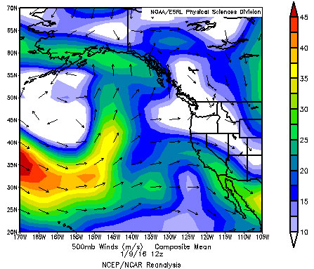
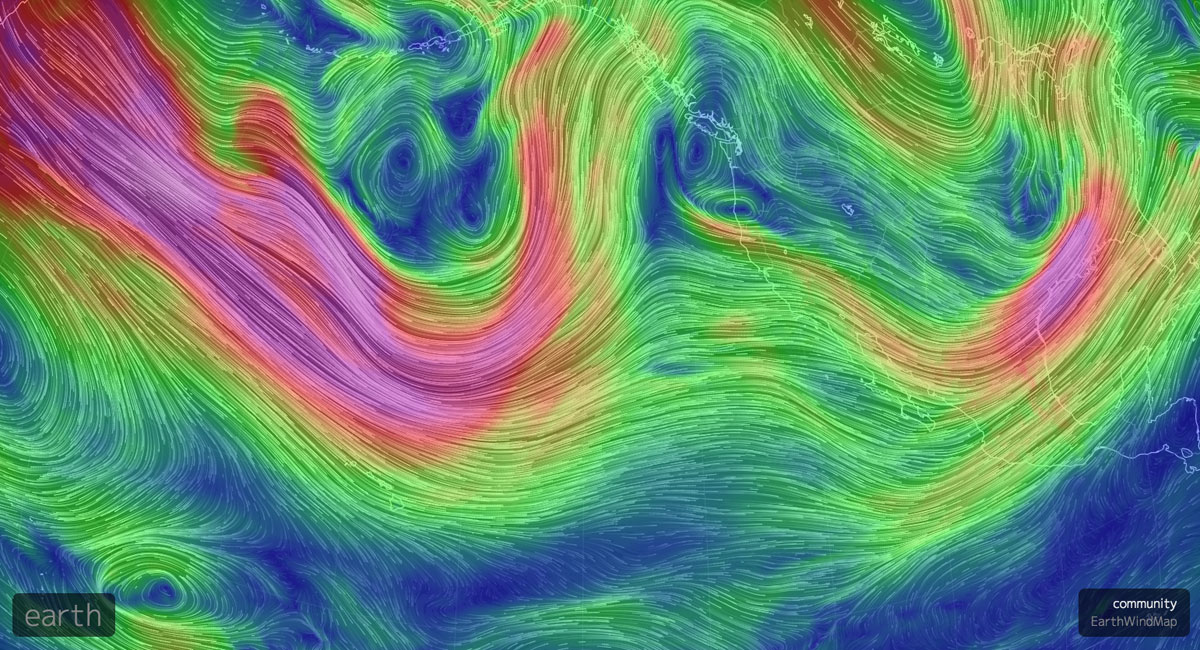
Most winter storms reaching North America’s West Coast are birthed far away, often in the northwestern Pacific where warmer subtropical air meets colder Arctic air masses. Once the storm forms its path eastward is influenced by the Pacific jet stream, or jet streams, plural. Textbooks commonly diagram two separate jets circling the globe, the polar and subtropical, one in the higher latitudes (the polar), the other in the lower, subtropical latitudes. Both flow easterly in an ever-changing sinuous path, often tracking more north-south than eastward, at times separate but often merging into one big jet. This is common over the Pacific Ocean which is why we often use the term “Pacific jet” rather than polar or subtropical. However, at times the Pacific jet will split into two branches, replicating the textbook diagram of two jets, one polar and other subtropical. Whether it splits or merges depends on the jet’s internal characteristics and its response to the atmospheric topography of high and low pressure. (The visualization above shows the Pacific jet in early January 2016, when it split into two branches, divided by a ridge of high pressure off the California coast; this split jet weakened Pacific storms in early January by breaking them apart, with one part carried northward and the other traveling into Central and Southern California.)
At times the Pacific jet will split into two branches, replicating the textbook diagram of two jets, one polar and other subtropical. Whether it splits or merges depends on the jet’s internal characteristics and its response to the atmospheric topography of high and low pressure.
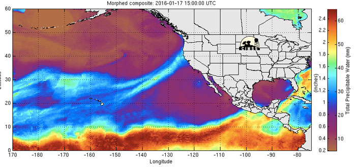
Back to our autumn El Niño rain. Conventional wisdom posits that a true El Niño storm is warm and wet, birthed in the subtropics, and steered into central California by the subtropical jet. By that definition the autumn storms were not El Niño storms because they were not particularly warm (witness the low elevation snow in the Cascades), and were steered toward land by a strong, unified Pacific jet. Further, and here the plot thickens, several of those autumn storms had their moisture content enhanced considerably by atmospheric rivers (ARs), those long, narrow, very wet streams of low-level moisture reaching south to the true tropics. When a Pacific storm taps into an atmospheric river, rainfall can be double or even triple the amount that falls in a ”normal” storm. The autumn storms that drenched the Pacific Northwest were quirky, in that atmospheric rivers are generally not associated with El Niño episodes. But this fall they were, and far Northern California benefited from this largesse.
Can these storms be considered El Niño storms? No and yes. No, if the narrow definition of an El Niño storm is applied (subtropical in origin; steered by the subtropical jet, etc.); yes, if one takes a broader, global view of El Niño (and remember El Niño is a global phenomenon with varied expressions around the globe) by asking a question like “how could those autumn storms not be affected by El Nino”?
When scientists studying the 2015-2016 El Niño return to their drawing boards, they’ll have to reflect on what happened, and why, and move closer to an answer. For the fall, at least. What’s happening right now in mid-January 2016 might be another story again.
What’s Happening Now, and What Might Happen in February and March
The quirky El Niño of 2015 looked like it would turn into a textbook El Niño during a 9-day post-Christmas dry spell, when the subtropical jet stream appeared and delivered a textbook Southern California El Niño storm. With heavy rain in the lowlands and snow in Southern California it was déjà vu all over again: streets flooded, Highway 101 just about closed from debris slides, the Los Angeles River rampaged out to sea, and scores of people were temporarily marooned in the mountains by snow. Godzilla was here, finally. Scripps scientists, I imagine, breathed a sigh of relief, just as they did in January 1998.
Remember, they are an exotic species in the Western United States, and are rapidly increasing their geographic range and range of habitats. Are they outcompeting or excluding native species in the process? How would we know? We have done almost nothing to monitor changes in the assemblage of mushroom species in areas before and and after the incursion of death caps.
Further Reading
Pringle et al, “The ectomycorrhizal fungus Amanita phalloides was introduced and is expanding its range on the west coast of North America,” Molecular Biology 2009
Lockhart et al, “Simultaneous emergence of multidrug-resistant Candida auris on 3 continents confirmed by whole-genome sequencing and epidemiological analyses,” Clinical Infectious Diseases 2017
Battalani et al, “Aflatoxin B1 contamination in maize in Europe increases due to climate change,” Scientific Reports 2016
Reading List
Each post in Bay Nature’s El Niño series features a reading list with links to more technical or scientific explanations.
- NWS Forecast Discussion, San Francisco Bay Area (rainfall reports are under “hydrology” on the left)
- CA Department of Water Resources, California Data Exchange Center
(precipitation, river stages, and reservoirs) - The Tahoe Daily Snow, by Bryan Allegretto
- California Regional Weather Server, jet stream maps
- The California Weather Blog, Enhanced El Niño Storm Track Has Finally Emerged
- Cliff Mass Weather Blog, Split Personality: The Future of Winter 2016 Over the West Coast of North America
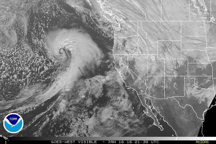
But in Southern California – where El Niño’s effects were supposed to be felt most — the appearance proved only temporary. In the second week of January a split jet directed a line of fast-moving, rather weak storms northward into the Pacific Northwest and Northern California – skipping the southern part of the state entirely. While Seattle grumbled about more rain after its wettest December on record, Northern California rejoiced (mostly) with every passing storm that brought snow the Sierra and rain to the coast.
Last week, the Pacific jet once again merged into a powerful single stream, and more powerful storms were directed at Northern California. Sunday’s event tapped into an atmospheric river full of tropical moisture, resulting in more than 2 inches of rain in 24 hours in many Bay Area locations, and a beneficial 4-6 inches in the Shasta-Oroville reservoir watersheds. The forecast for the remainder of January looks promising here, with continued storminess.
Was this storm a portent of things to come, a Godzilla that contrary to the textbook, preferred Northern California to Southern? Good question. Certainly the forecast models suggested that could be the case through the rest of January, with a deep low pressure trough over the West Coast and a ridge of high pressure north of Hawaii that would keep the Pacific jet aimed at Northern California and the Pacific Northwest. Certainly that’s not the classic El Niño pattern, but who will complain if our Northern California reservoirs fill up?
Looking down the weather pike into February and March, Daniel Swain, the must-read weather blogger and Stanford climate scientist, suggested in a post on Jan. 17 that the Pacific jet would soon intensify and move southward in classic El Niño manner. If that verifies, then Southern California can expect some strong storms next month.
Halfway through the rainy season there’s no question that El Niño is alive and well, and that it will continue to bring stormy weather to the Bay Area over the next few months. What’s still an open question is whether the jet stream will remain quirky and steer those storms into Northern California and the Pacific Northwest, or whether a subtropical branch of the Pacific jet will become the dominant storm steering force, sending the rain to Southern California where, according to the textbooks at least, it was always supposed to go.