.jpg)
Superhighways stay out of the Delta, mostly. But if you have ever driven on Interstate 5 south of Stockton, you have just grazed one of the southernmost Delta islands, Stewart Tract. Filling the angle between the San Joaquin River and Paradise Cut, one of that river’s lesser branches, it is also at the intersection of two specifically South Delta concerns: urbanization and flood control.
At this end of the Delta, much of the land is above sea level, with little or no peat soil left. Tidewater inundation is not a worry. Anxiety comes instead from the San Joaquin, a shrunken, controlled stream that nevertheless can pack a wallop when warmer winter storms bring rain instead of snow to its mountain watershed. The last time this happened, in 1997, levees broke throughout the region and damage between Manteca and Tracy amounted to $80 million.
Stewart Tract flooded, too, but being unpeopled, it sustained little harm. More than that: By absorbing waters that would have spread elsewhere, Stewart acted as a safety valve, keeping the regional destruction down.

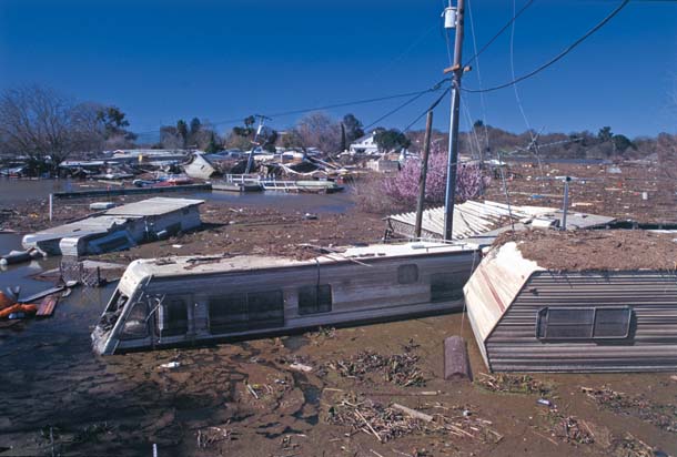
- Island Mobile Home Park along the San Joaquin River near Manteca was still under water a month after floodwaters engulfed it in January 1997. Photo by Tom Myers, tommyersphotography.com.
Now a massive development called River Islands is expected to replace melon fields on the entire seven-square-mile tract. To safeguard its population against flooding, the new city is to be protected by levees far wider and stronger than the Delta norm.
When the plan was announced, it drew heavy fire from environmental groups and also from its neighbors in the region, who decried the loss of the safety valve. Out of the fracas came a paradoxical settlement by which River Islands would provide money for alternative flood solutions–and a significant slice of land as well.
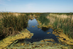
The key to the plan is Paradise Cut, the slough that bounds Stewart Tract on the south. It isn’t much to look at, these days. Where I-5 crosses it, it’s little more than a soggy ditch with a few reeds and willows poking out of it. But the Cut is historically one of the chief distributary branches of the San Joaquin. Twice during the 19th century, it carried the main force of the master river. It may someday do so again. Says John Cain of the nonprofit American Rivers: “Expanding Paradise Cut is essential to direct floodwaters away from the urbanizing floodplains in Lathrop and Stockton, and it will restore a tiny fraction of the habitat the Delta has lost.”
For starters, River Islands’ developers agreed to place its big new levees well back from the bank of Paradise Cut, opening a strip seven miles long and at least 1,000 feet wide to seasonal inundation. Riparian forests, the most cruelly reduced of all the Delta habitats, could reestablish here. And the Bay Delta Conservation Plan foresees large areas of restored marsh downstream from the Cut, into which these floodwaters could feed, a biologically potent combination.
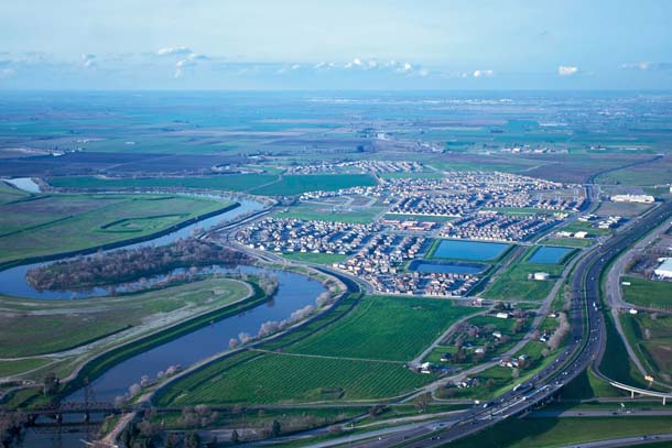
- The I-5 freeway crosses over the San Joaquin River near Lathrop. A new housing development sits across the river from Stewart Tract, which is also targeted for residential development. Photo by Patrick Kelly, sfoap.com.
Someday the Paradise Cut corridor may be a link in a chain of protected lands extending northwestward into the heart of the Delta and southeastward, into the San Joaquin Valley, to encompass the San Joaquin National Wildlife Refuge and Caswell Memorial Park on the lower Stanislaus River, where a rare fragment of mature riparian forest remains.
For a small taste of what is possible, you can take Paradise Avenue north out of Tracy to reach a lower stretch of Paradise Cut. Here you find not one channel, one bridge, but a pair, with a grassy island between. Unlike the armored outer banks, the island is low and undefended against high water. Among the dun-colored surrounding fields, it seems almost lit up with its lively green. You can forget that the water pooling in these channels consists entirely of used irrigation flows. A great blue heron doesn’t seem to care much, either.
If plans go through, the linear park of this floodplain will be greatly widened, and will regain connection with a living river. Will that seem sufficient compensation for the houses that will also appear on the empty horizon of Stewart Tract beyond? A few years from now (if the economy picks up), we will know.