.jpg)
Fifteen miles north of San Francisco, a curvaceous stretch of Highway 1 seems to hover just above the waters of Bolinas Lagoon. At high tide, ducks and other waterbirds dabble and dive only a few feet from passing cars. A driver or bicyclist is left to navigate a narrow ribbon of asphalt between the steep slopes of the Bolinas Ridge and the pale mirror of the lagoon.
This is one of a slim handful of tidal estuaries on the West Coast, and in 1998 it was designated as a Wetland of International Importance. Great flocks of birds overwinter here, and harbor seals can often be seen lolling, loglike, on the lagoon’s shoals. A major nesting colony of herons and egrets sits in a canyon just above the lagoon’s sheltered waters, which act as a nursery ground for salmon, perch, crabs, and myriad other fish and invertebrates.
“Incredibly marvelous things happen when freshwater meets sea-water,” says Joe Mueller, a College of Marin biology professor who has been observing the lagoon for 30 years. “That’s where all the stuff that’s needed for explosions of life occurs.”
Yet the lagoon seems to be filling in, and people have debated for decades whether this is a natural process best left alone or the product of human impacts on a once-dynamic system. Highway 1 and other roads have hardened its inland edges. The towns of Bolinas and Stinson Beach anchor the cove’s seaward corners, while Seadrift, a gated residential community built on a sandy spit, limits its exposure to wind and waves. Its 17-square-mile watershed has been subjected to more than a century of logging and other human uses and abuses. Throw in climate change and sea level rise, and it becomes nearly impossible to parse the human from the nonhuman influences here–or to predict their effects.
“This is a complicated issue because the lagoon is the centerpiece. It’s the key to our lives here,” says Rudi Ferris, a lifelong Bolinas resident and surfer who is vice chairman of the Bolinas Lagoon Technical Advisory Committee, which guides county management decisions on the lagoon. But Ferris has his perspective: “The problems with the lagoon are man-made. This is my viewpoint and one that is only partially shared by scientists.”
There are almost as many viewpoints on the lagoon’s health as there are residents in the watershed. A century ago, just after the great 1906 quake jolted West Marin, the lagoon was twice its current volume. Yet maps from a few decades earlier show a much shallower estuary similar to the one that we know today; in 1854 the lagoon’s mouth was documented at one foot deep at low tide. As early resident J.P. Munro-Fraser wrote in his history of the area, “When vessels first began to sail into [Bolinas Lagoon in the 1830s], a schooner drawing ten feet of water could pass over the bar with ease at any stage of the tide. . . . Old sailors are free to assert that the day is not far distant, at the present rate of filling in, when the entrance will be entirely closed.”

- The narrow inlet from lagoon to ocean is visible between the bluffs of Bolinas and the sandy strip of Stinson Beach. Just below that is the artificial Seadrift lagoon, which diverts nearly 10 percent of the natural lagoon’s volume. Photo by Ed Callaert.
As I slog along a muddy trail on the north side of the shore, the evidence of the present filling is hard to miss. Dressed comfortably in khakis and a blue pullover, my guide Burr Henemen points out several patches of vegetation rising above the muck in the center of the lagoon.
“Those islands of salt marsh–they are all new and they get bigger each year,” says Henemen, a Bolinas resident, scientist, and former executive director of PRBO Conservation Science (which has operated a field station nearby for decades). “Sometimes 10,000 western sandpipers will be here during migration. But if the mudflats convert to salt marsh, that will be lost.”
In the last 40 years, 120 acres of the 1,100-acre lagoon have converted into salt marsh. Salt grass, pickleweed, and other plants take root as mud, sand, and silt pile higher. Islands solidify and grow, and open water and tidal mudflats gradually make way for meadow.
In theory this is normal–all estuaries are in a perpetual state of change. The balance between sedimentation and erosion is constantly shifting; sea levels and coastlines change. But people here have long questioned whether this lagoon should be filling in quite so fast. After all, geologists say it has persisted in a watery state since the end of the last ice age, more than 7,000 years ago. And since Europeans arrived in California, over 90 percent of the region’s tidal wetlands have been lost–largely because of human development and other activities. For decades, scientists and locals alike believed Bolinas Lagoon was en route to becoming another casualty unless they took major action to save it.
“The old picture was that things got out of balance when we started logging, potato farming, cutting firewood, and whatnot on the slopes of Bolinas Lagoon,” says Henemen. “Now there’s some question as to what extent those changes in the lagoon are caused by human activity.”
- As the lagoon has filled with sediment and become shallower, it has become increasingly difficult for fishing boats and other watercraft to use the Bolinas harbor. Photo by Richard Blair, RichardBlair.com.
The modern movement to save the lagoon was born when scientists realized that it had lost 25 percent of its volume and 7 percent of its estuarine habitat from 1968 to 1988. Environmentalists worried about birds and other wildlife, fishermen worried about their boats and their catch, and homeowners worried about the views and the health of their beloved lagoon. The movement soon gained momentum, funding, and political clout. Eventually the Army Corps of Engineers developed the agency’s first-ever environmentally motivated restoration plan.
But the plan that the corps unveiled in 2002 called for 296 straight days of dredging that would remove nearly 1.5 million cubic yards of material. Faced with the project’s unprecedented scale, scientists seconded the objections of the Sierra Club and other environmental groups. The tide of public opinion soon turned, and the multimillion-dollar plan was tabled.
“A lot of people felt [the corps plan] was going a little overboard and didn’t provide a good idea of what the lagoon would look like after the project, or how it would evolve if we did nothing,” says Bill Carmen, a consultant who now manages planning of the lagoon’s restoration for Marin County.
So the firm Phil Williams and Associates was hired to do the first detailed analysis of the sediments clogging the lagoon. The resulting 2006 report upended traditional assumptions. Only about 20 percent of the sediment came from the watershed–some from natural processes and some from human activities. The remaining 80 percent came from the ocean. The study also suggested that any large-scale dredging would have to be continually maintained. On the other hand, if it were left alone, the lagoon would probably lose up to half of its volume, but it would be unlikely to close off entirely.
The lagoon owes its longevity, in large part, to its position atop the San Andreas Fault. The jolt of the 1906 earthquake dropped its floor by several feet, which is what caused its volume to abruptly double. Scientists speculate that previous quakes, occurring every 250 years on average, may have kept it from filling in.
“It’s pretty unusual to be looking at a system like this and be able to say, ‘Well, maybe it’s OK to step back and let it evolve,'” says Phil Williams, who conducted the 2006 study.
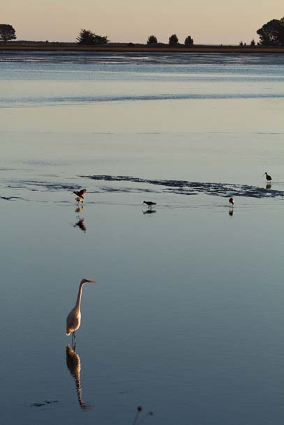
- A great egret and several other shorebirds hunt in the early evening light in Bolinas Lagoon, a shallow estuary along Highway 1 just north of Stinson Beach. Photo by David Wimpfheimer, calnaturalist.com.
The new, more moderate interpretation of human influence on the lagoon resulted in a scaled-back restoration plan released in 2008. The plan calls for limited dredging, elevating portions of Highway 1 on causeways, and removing invasive species.
“In my opinion, the goal is to restore, as much as possible, the natural processes that would be happening if humans weren’t here,” says local Sierra Club activist Gordon Bennett. “Will we ever get back to an 1845 lagoon? No we won’t. But can we change the trajectory of the lagoon so it’s a little bit healthier than it would have been? I think yes.”
Despite the apparent consensus, no restoration has yet been done. The management plan, though widely endorsed, has to pass through multiple reviews and regulatory hurdles, all of which take time and money. Funding is scarce, both because political momentum has faltered and because of the country’s challenging economic climate.
“We’re not sure where the money would come from to move forward,” Carmen says. “It’s a slow process.” Still, smaller restoration projects are poised to move forward as early as next year, starting with the removal of invasives from Kent Island (a small shoal in the middle of the lagoon that’s been overtaken by nonnative weeds and trees).
Meanwhile, the lagoon continues to collect silt. Back along the shore with Henemen, we pass through a grove of willow and alder. “Right now we’re walking out along a watercourse that wasn’t here, through a forest that wasn’t here 40 years ago,” he says. “The amount of upland is gradually increasing and nibbling around the edges of the lagoon.”
We’re traversing a tongue of land known as the Pine Gulch Creek delta, one of many parts of the watershed undeniably affected by people. Unable to meander and slowly drop its sediment, the creek has channelized and now shoots its load of silt deep into the lagoon.
In the distance, the houses of Seadrift stand in hunched rows of sun-bleached shingle and wood. Their flanks hide an artificial inner lagoon that sucks out nearly 10 percent of the main lagoon’s volume. Less water means less energy to flush sediment back out to sea, Bennett tells me later.
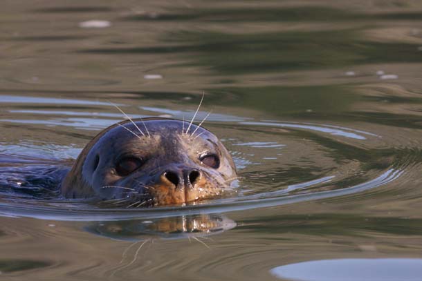
- The sheltered lagoon is a favorite haunt of harbor seals like this one. They often haul out on the mudflats at low tide. Photo by Galen Leeds, galenleeds.net.
Small fishing boats roped to the dock of the Bolinas Rod & Boat Club list sideways on the mud as the tide drops. Local fishermen and crabbers have long been vocal advocates for dredging–as the lagoon fills in, they can use their boats less often every year, and many now anchor in the less safe but more accessible outer channel of the lagoon.
The fishermen also say fish populations have been in steady decline. “There’s a few perch in the lagoon still but it’s nothing like when I was a kid,” says Josh Churchman, a commercial fisherman who is now 59. “When certain species drop off you have to think the health of the lagoon is dropping with them.”
Still, there’s no question that this remains a vibrant ecosystem. “When it comes to changing sunlight into life, what we have right in our backyard is as productive as a rain forest,” says Mueller. “You don’t see the colors or the howling monkeys, but all that same stuff is going on–it’s just hidden in the mud and in the tides.”
Proximity to San Francisco is another feature that makes this place so valuable. “It gives people a real chance to enjoy nature without really harming it,” says Gary Page, PRBO Conservation Science’s wetlands ecology director. “It’s very accessible and the wildlife has become fairly habituated to people–but it’s also fairly undeveloped compared to, say, Bodega Harbor.” Most researchers agree that both the mosaic of tidally influenced habitat and the connection to the ocean are important features to preserve. “You don’t want to manage the geomorphology for its own sake,” Williams says. “You want to make sure the lagoon is evolving in a way that provides valuable habitat.”
- Kent Island, once a transient shoal, is now thoroughly vegetated and fixed in place. Photo by Laurie Search, lors.redbubble.com.
Mueller takes his students out to catalogue the creatures along the shore and among the muddy pilings of the houses on Wharf Road in Bolinas. “You’ve got crabs, you’ve got worms, you’ve got nudibranchs,” he says. “A good portion of the creatures that live at sea or along the continental shelf grow up in the estuaries.”
Just how to safeguard that diversity–if we can protect it at all–is the big question. In the last few years, scientists have realized that climate change throws a clinker in all the plans and worries surrounding the lagoon. While sedimentation may yet be a problem, it now seems just as likely that the lagoon will drown.
“It’s not going to fill [with sediment]. It’s going to fill with water,” says John Kelly, director of conservation science at Audubon Canyon Ranch, which conducts research here and protects the nesting egrets and herons. “Some things that people are worried about may be reversed or lessened by sea level rise. It may not need to be managed, or if it does it may not be for the things we originally thought.”
In the five years since the sediment study was completed, average projections of sea level rise by 2100 have gone from six inches to three feet, with some researchers predicting even greater rises. The Intergovernmental Panel on Climate Change warns that up to a third of the world’s coastal wetlands could be open water by 2080.
Because the Bolinas Lagoon shoreline has now been hardened by development, there is nowhere for the marsh to migrate. The mudflats and salt marsh could become entirely covered, even at low tide–and all the species that depend on them would be squeezed out. “Areas that don’t have low geographic terrain around the edges, like Bolinas Lagoon, are going to lose–and that’s a fact,” says Kelly.
Roads and houses are also threatened. Highway 1 sits just above sea level, and low areas already flood in heavy storms. “Seadrift is going to wash over,” Kelly says. “Those houses are doomed.”
The current plan includes some mitigation measures to address sea level rise, such as elevating portions of Highway 1, but little can be done without major infrastructure changes that would require massive funding.
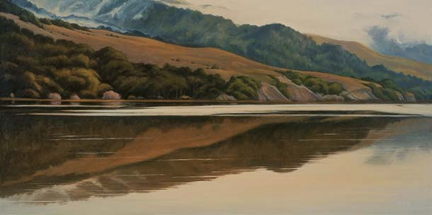
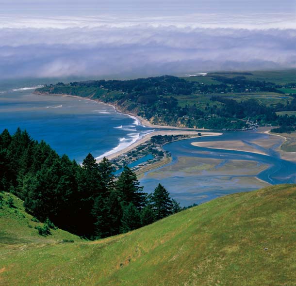
- The steep slopes of Bolinas Ridge plunge into the lagoon, interrupted by a low shelf of flat land for Highway 1 along the east side of the lagoon. Painting: “Bolinas Lagoon–January Afternoon,” 24”x48”, oil/canvas. Christin Coy, christincoy.com.
And projecting the effects of rising seas–and what should be done about them–is at least as challenging as deciphering the causes of sedimentation. A moderate rise could just keep pace with the filling of the lagoon. But a more significant rise would drown much of the valuable habitat. It’s even harder to predict how this ecosystem will react to broader climate change impacts such as warmer ocean temperatures and changes in birds’ arctic breeding grounds.
The expensive studies done in recent decades also may soon be swamped, as the assumptions on which they were founded get negated by conditions on the ground. Debates over dredging could be washed over by global changes far beyond the control of the fishermen, ecologists, and others trying to chart the future of this ragged triangle of bay.
For now, the lagoon still darts inland, a fin-shaped wedge of sea at just the right depths for all the diversity Mueller and his students have catalogued for decades. How long that will last, no one can say.