.jpg)
A professor of architecture by trade, Cris’ Benton’s avocation — “It’s more than just a hobby, ” he stresses —and main passion is the field of kite aerial photography, or KAP. Benton enjoys the aesthetic as well as scientific aspects of the field. Many of his aerial photos can be found in Bay Nature magazine, including shots of “The Weep,” a biologically-rich site in the South Bay Salt Ponds.
BN: Where are you from, originally, and what brought you to the Bay Area?
CB: I grew up in Georgia, and came out here 27 years ago to take a job as an associate professor of architecture at UC Berkeley. I’m still there.
BN: You’re well-known for your expertise in the field of Kite Aerial Photography. Tell us about this pursuit.
CB: KAP lets you take low-cost aerial photographs from 10 feet to 300 feet above the ground. Air traffic is generally not supposed to go lower than 500 feet, so KAP provides a method for detailed documentation of an area from low altitudes—for instance, the course of a creek or the small section of a watershed. The best images for me have compositional merit and are useful in a way of reading the landscape.
BN: So it’s not simply a “fun hobby”.
CB: No, it’s used both for environmental assessments and citizen-science level observation. It lets geomorphologists map rock outcroppings, lets landscape designers map the “desire paths” people create … I’ve even consulted on mapping the breathing holes manatees make in water-hyacinth mats in Costa Rica!
BN: How does it work?
CB: You hold the camera in a cradle, which is radio-operated. The cradle is connected to a kite, and hangs about 150 feet below the kite when it’s up in the air. The apparatus lets me rotate the camera through the compass, tilt from the horizon to the ground, go from landscape to portrait format, and fire the shutter.
BN: When did you start playing – and working – in this field?
CB: I started in 1995 just for fun—before that I was a radio-controlled sailplane flyer.
BN: Is KAP new?
CB: No, it’s been around for over a century. There have been three main epochs: The golden age of kite photography was the late 19th and early 20th century, the time before aircraft. Back then It was a really novel thing to capture an aerial view. There’s a classic panorama of San Francisco right after the earthquake: A man named George W. Lawrence used a 50-pound camera suspended in the air to get that shot.
The middle epoch came mid-20th Century, after airplanes came along. While inventors played around with photography from kites during this period, it was always in isolation and there were few advances. The third epoch came in the 1990s, at the beginning of the Internet. KAP enthusiasts around the world could finally find each other, share their techniques, and publish their images on the Web. When I started there were maybe 20 people worldwide that did it seriously. Now there are over 200 who are seriously involved in KAP, and thousands who dabble casually.
BN: What intrigues you about it?
CB: It involves invention and learning the vagaries of kites. It also combines two of my passions: photography and geography. And it’s a very social act – people always want to know what you’re doing when you’re outside flying the kite.
BN: Can you see what the camera sees?
CB: You can use a video capture, but I prefer “imagining” the image: I have a visual hypothesis of what that image will be. It’s interesting to compare this mind’s-eye view with the actual result.
BN: One of your interesting projects is the “Hidden Ecologies” project in the South Bay. Tell us about that.
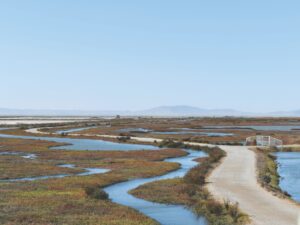
CB: The Hidden Ecologies project sprang from a 2003 sabbatical when I was an Artist-in-Residence at the Exploratorium. It involved looking at transitional landscapes adjacent to the Bay at different scales; one of our early sites was the South Bay salt ponds. I started hiking with Dr. Wayne Lanier, a microbiologist, and we produced photos at our different scales: the colors made by microorganism communities, for example, as well as the salt pond landscapes as a whole. It has evolved into a sustained longitudinal study of what is a fascinating landscape. Our salt pond images tell the story of a former marshland that had been converted to salt production and is currently being returned to management for the public good.
You can read the history of the place through our images: you can see vestigial traces of old salt works and former marsh channels going back to the 1850s and 60s. I’ve learned a lot about transportation epochs; this landscape was shaped by shipping then railroads and now highways. It’s been a transitional landscape and continues to be a transitional landscape.
BN: You really enjoy history, don’t you?
CB: Very much. After I retire I want to photograph the Coastal Defense Works at Point Bonita in the Marin Headlands—the series of defense installations there. The idea of military structures returning to the earth is fascinating to me.
BN: Where are your favorite natural places in the Bay Area?
CB: Point Reyes and the South Bay. Point Reyes is special for its geographic variety and relatively untouched natural state. I am drawn to its exposed headlands, the quiet estuaries, and the peninsula’s intricate topography and microclimates. The South Bay, on the other hand, is a vast, flat plane. There, in the middle of the Bay’s 7 million residents, you can find isolation and connect to a remarkable variety of wildlife. I think the big draw, however, is the transitional nature of the landscape – it has seen so much change in the last 150 years and continues to evolve in our current day. I am repeatedly drawn to this exuberant, otherworldly place.
To learn more about Kite Aerial Photography, visit:
The Kite Aerial Photography Discussion Page
The Flickr KAP image group