.jpg)
Stevens Creek is a 20-mile stream that originates on Black Mountain at the crest of the Santa Cruz Mountains before cutting through the heart of Silicon Valley and out into San Francisco Bay. Eventually, the Stevens Creek Trail will run the entire length of the stream. For now, the $12 million highly engineered six-mile trail follows the creek as it cuts a riparian corridor across urban Mountain View. Bicycle bridges were built, pedestrian tunnels lighted, sound-barrier walls erected, and levees landscaped, so that South Bay residents could escape, via pedal-power or on foot, to the relative tranquility of this six-mile pathway to the Bay.
Caltrain and VTA light-rail provide access to the trail at the Mountain View Transit Center. Local buses can also drop you off at El Camino Real near Yuba Drive where Stevens Creek Trail starts.
The city parks that border the creekside pathway every few blocks are a definite plus. Cottonwood, oak and willow mixed with exotic eucalyptus, ornamental vines, and bushes block the nearby cityscape. Raccoons still feed on crayfish when Stevens Creek brims with winter rain. The chatter of squirrels and sparrows in the trees mixes with traffic noise to give this trail its combined natural and urban character.

- Black-necked stilts take flight at Palo Alto Baylands. Photo by Allen Edwards Photography, PaloAltoPhoto.com.
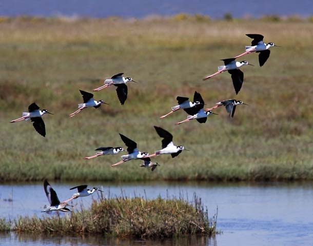
The cacophony of Silicon Valley melts away as the Stevens Creek Trail meets the Bay Trail at Mountain View’s Shoreline Park. The Bay Trail abuts tidal salt marshes, ponds, and sloughs from here into Palo Alto Baylands Nature Preserve and all the way north to Ravenswood Open Space Preserve. These wetlands are an important site along the Pacific Flyway for thousands of migratory and resident shorebirds and waterfowl. Not surprisingly, this is a favorite locale for birders to observe egrets and herons stalking prey on the mudflats, killdeer crying from nests in the pickleweed, ducks and grebes feeding on algae, terns banking over shallow salt ponds, and a small colony of black skimmers dipping their beaks into Charleston Slough. Seems incredible that this 700-acre park, with its scenic bay-front and burrowing owl habitat, was a landfill through the 1970s.
To the east, you can see Moffett Federal Airfield with its huge dirigible hangars and research facilities. By mid-2009, a new segment of the Bay Trail will open along the bayshore side of Moffett Field, connecting to another seven miles of Bay Trail in Sunnyvale.
A good end for your outing might be a stop at Shoreline Lake, where you can rent a kayak, sailboat, or windsurfing board. After an hour on the water, you can grab a sandwich at the dockside café, then ask directions to the nearest bus stop a few blocks away at Charleston and Amphitheater Parkway (VTA #40). Or you can retrace your route back to the Mountain View Transit Center.
-300x172.jpg)
-300x201.jpg)