.jpg)
When I returned to the United States from Asia at the age of eight, I’d forgotten I was born here. I couldn’t wait to see the land so fabled in song: the purple mountains and amber grain. All I saw from my Berkeley neighborhood, though, were more houses like ours. No wonder my teacher struggled to convey to us third-graders the meaning of a simple anthem. We’d never seen grain. A fruited plain was out of the question.
“Wait. Have you ever been up to the hills in summer?” she asked suddenly, startled by her own brainstorm. Several children nodded.
“It’s full of yellow grass,” one boy said authoritatively.
“That’s right,” the teacher said. “Amber waves of grain look a little like that. And look up there.” She pointed out the window. “They’re not as big as mountains, but they’re pretty majestic, don’t you think?” We followed the end of her finger to a view of the hills, at that moment cloaked in winter emerald. There were a lot fewer houses on the slopes back then, and to a child’s eye they were grand indeed.

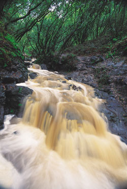
- The East Bay Regional Park District has preserved a broadarray of landscapes, including this shady waterfall on Wildcat Creek inBerkeley. Photo by Galen Rowell.
That iconic sense of terrain—the notion that geography, untrammeled and untamed, can represent the spirit of a great place to live—is the reason we in East Bay cities are privileged to have empty emerald hills in the middle of some of the most densely populated territory in Northern California. The people who established the East Bay Regional Park District (EBRPD) in 1934 knew open space wasn’t just a good idea for its own sake; it was symbolic of gentility, of leisure, of a quality of life beyond bare nuts-and-bolts survival. Preserving the wild is arguably the first achievement of civilization, because it’s only possible when people realize they’ve done enough civilizing and stop to appreciate the value of building nothing at all. When the park district marks its birthday on November 6, it will celebrate 70 years spent keeping open space open.
“I think the district has always been forward-thinking,” said EBRPD’s general manager William Penn Mott in a 1981 oral history. “The original district came into being because Eastern subdividers were going to buy the hill lands and develop them into housing. That scared everybody.”
As far back as 1866, landscape architect Frederick Law Olmsted (of Central Park fame), impressed by the wild beauty of the Oakland-Berkeley hills, had urged their preservation via parks and “scenic lanes.” At around the same time, entrepreneurs were competing to bring water to a growing population. In 1868, Anthony Chabot hired Chinese workers to build a rammed-earth dam across Temescal Creek in the East Bay hills. His was one of many small, independent water companies, each protecting its own small cachement reservoirs and surrounding watershed like dogs guarding a bone. And just like a pack of surly hounds, the private water companies battled, failed, or consumed each other until one, the East Bay Water Company, emerged victorious, the proud owner of 40,000 acres of competitors’ land.
But by 1928, after finishing a new 90-mile pipeline to bring Sierra snowmelt to local reservoirs, the now-public East Bay Municipal Utility District (EBMUD) didn’t need the cachements built by its independent predecessors and declared 10,000 acres of watershed surplus. At the time, Alameda, Albany, Berkeley, El Cerrito, Emeryville, Oakland, Piedmont, Richmond, and San Leandro shared just 900 acres of public parks—an embarrassingly paltry figure when measured against comparable urban areas of the time, such as Boston (18,196 acres) or Fort Worth, Texas (9,000 acres). Hikers, hunters, fishing enthusiasts, and hills residents eyed the fenced watershed with the yearning of children peering into a bakery store window.
The threat of urban creep up the slopes of Grizzly Peak and into Wildcat Canyon prompted hiker Robert Sibley and Berkeley city manager Hollis Thompson to organize a park association in 1928, with the goal of convincing EBMUD to donate those 10,000 acres for parkland. They were joined by the Sierra Club, Oakland Park League, the Oakland Recreation Commission, and others. Two years later, as the East Bay Regional Park Association, the group issued a report echoing Olmsted’s vision: “With the growth of a great metropolis here, the absence of parks will make living condition [sic] less and less attractive, less and less wholesome. In so far, therefore, as the people fail to show the understanding, courage, and organizing ability necessary to grasp the present opportunity, the growth of the region will necessarily tend to choke itself.”
The only way to realize the grand vision of a 22-mile public park—sweeping across city after city, along the ridgeline from Wildcat Canyon to Lake Chabot—was to unite those cities in a single regional authority, much like EBMUD. This entity would have the ability to raise money through taxes and the sale of bonds, and to manage the proposed parks. The concept of a dual-county, multi-city district governing public parks was so innovative that special legislation was needed to establish it. AB 1114 was signed into law in 1933, creating what today is still the nation’s largest regional park district.
Next, voters had to approve a property tax—a nickel on every $100 of assessed valuation—to pay for the district. Contra Costa County dropped out, mostly due to objections by farmers: In the middle of the Great Depression a nickel was real money, and who wanted to spend it for open space when they were tilling plenty of that each season? Alameda County went solo, passing the tax initiative by a ratio of 2.5 to one in November 1934.
The first task of the new district’s board, led by Major Charles Lee Tilden, was to go mano a mano against Tilden’s nemesis, George Pardee, president of EBMUD’s board. Pardee demanded $6 million for the 10,000 acres, but the new district had less than a million to spend, so it ended up agreeing to purchase its first 2,163 acres for $656,544. Those acres became Lake Temescal, Tilden Regional Park, and Sibley Volcanic Regional Preserve. Thirty years would pass before the district could purchase the rest of the 10,000 acres.
At first, the district operated with a staff of two—General Manager Elbert M. Vail and Secretary-Treasurer Georgette Morton—and with muscle provided by two federal work programs, the Civilian Conservation Corps (CCC) and the Works Progress Administration (WPA). The 17- to 23-year-old workers built Skyline Road to connect the parks, as well as archery ranges, playing fields, trails, and picnic sites. They quarried stone for an administration building next to Lake Temescal (still in use as a bathhouse). An earthen dam across Wildcat Canyon created Lake Anza, used as a reservoir to water Tilden Park’s golf course. Resourcefulness on a shoestring was a hallmark; the beloved Brazil Building at Tilden Park, for example, was created from the recycled remains of the Brazilian Pavilion at the 1939 World’s Fair at Treasure Island.
More than a million people a year visited the parks, Vail was proud to report in 1939 —”The crowds are so large they cannot be accommodated comfortably.” That changed in a matter of months with the advent of World War II. Vail resigned in 1942, and most of the 30 employees on payroll before Pearl Harbor left to join the service or defense industries. Only six staff remained to carry on during the war years.
While public attendance fell, the parks filled with another group of visitors. The Army Defense Command moved into Tilden Park, attracted by the wooded terrain (perfect for practice bivouacs) and the empty ccc barracks (perfect for convalescing soldiers). Preflight students were given a daily can of C rations and turned loose in Redwood Park to forage as part of their two-week survival training. Park supervisor Jim Howland remembered looking toward East Ridge Trail as a boy and seeing freshly dug graves each week. “A grave registration training battalion . . . would practice digging graves, setting them up and grading them out,” he explained.
In the postwar years, a can-do attitude prevailed; the idea that parkland could be preserved as pure habitat and open space is a fairly recent development. Parks weren’t supposed to sit there and look pretty; you were supposed to do stuff in them. You hiked, of course, but you also played golf, swam in the lakes, picnicked, played tennis, listened to concerts at the Brazil Building, flew model planes. And everyone was having kids, so the parks became family entertainment centers. Tilden Park added a carousel, pony ride, and steam trains, the Nature Area, and the Little Farm. If you grew up in the area around that time, Tilden was the center of the weekend universe.
I did, and that park, with all its gewgaws and attractions, did much to develop my lifelong respect for nature, simply because it was there, a poor man’s Yosemite just a gallon of gas away. I loved the ponies, the ranger talks, and feeding the burro, but I’ll never forget the first time my brother and I were allowed to walk around tiny Jewel Lake all by ourselves. The hush in that atmosphere of heavy, overgrown foliage, thick with a chartreuse glow, pushed the city so far away I believed I’d actually been to Narnia and back.
Another time, my father took me to a sunny, grassy hill to fly a kite—it may have been in Grass Valley, now part of Anthony Chabot Regional Park. We were untangling the string when he whispered: “Oh, Jesus H. Christ!” Paused on a rock 20 feet away was a small, tense, silvery bobcat. A second later it was gone, as if we’d imagined it. Bobcat sightings were rare then, and I remember feeling glad they still lived in this place where the chaparral touched the sky.
Over the next decades, EBRPD would expand in both arenas, developing recreation areas for city-weary visitors and expanding its acquisition of wilderness space, especially with the hiring of William Penn Mott in 1962. “Mott woke the sleeping tiger,” recalls former assistant general manager Jerry Kent. “I came on as a park ranger just as he started stirring things up. At the time it was a pretty small district, 8,000 or so acres and 100 employees—the backdrop to the parks we have now. I had a front row seat to the expansion, and I was mesmerized.”
The first thing Mott did was to straighten out the district’s laissez-faire finances and pursue federal and private funding. Citizens in Contra Costa County, tired of waiting for local government to create parks, re-joined the district in 1964. “They’d had a city parks system out there for four years, and they had Kennedy Grove with one picnic table on it,” recalled former district board member Clyde Woolridge. “And people didn’t think that was quite enough for four years’ effort . . . so we had a pretty good thing to sell.” Mott also proposed raising the park tax from five to ten cents to carry out his plan to buy Contra Costa land before builders did. “That’s always difficult because, just like today, [some] people can’t understand why you have to buy more land when you’ve got land that’s not even developed,” Mott said. “We were thinking in terms of what was going to happen when this whole area mushroomed into a residential development and trying to anticipate that by buying the land in advance of that development.” (The tax wasn’t approved until 1971, after Mott left to work for the state parks department.)
As more cities annexed to the district, acquisition extended beyond the “classic parks” along the ridgeline. The new parks represented a changing attitude toward open space as habitat to be preserved rather than developed for family entertainment. “That was the beginning of the district as people know it today,” says Kent. Sunol Regional Wilderness Park, purchased to serve Pleasanton and Livermore residents, and Las Trampas Regional Wilderness, the first new purchase for Contra Costa County, were “unique in character,” Kent points out. “When we started getting into the big-acre parks—Sunol alone is 3,000 acres—we obviously couldn’t develop them all, so they were left in a natural condition. We continued historic grazing because that helped with fire protection, and added minimal staging areas, but otherwise we left them alone. That was a new concept in the 1960s.”
With Woolridge’s support, Mott turned his sights from the ridge to the shore. “We had nothing in the flatlands,” Woolridge recalls. “We were hill people . . . We didn’t pay any attention to the beaches or the flatland until Bill Mott got in.” Coyote Hills Regional Park, just north of the Dumbarton Bridge, was added in 1967. The marshland around the hills was supposed to be transformed into a $50 million development with marinas, artificial lakes, and hotels, until developers decided the site was too far from the Bay and that it’d be a bad idea to plow up the native burial sites they’d discovered. In a partnership that typified Mott’s approach of stretching a dollar while saving land, EBRPD agreed to buy the hills portion of the property; the Alameda County Flood Control District bought the wetlands. Today it’s jointly managed as a “resource park,” wildlife refuge, and repository of Indian history. Also in 1967, the district took over management of Crown Memorial State Beach, which was the site of “Coney Island of the West,” Neptune Beach, from 1917 to 1939. Typical of some of the parks’ “natural” landscapes (which are filled with trees diligently planted by work crews), Crown Beach is a human construction. Its artificial beach was created for a housing development that was never built, and it became a nightmare of erosion problems. At last, in 1982, the district took more than 200,000 cubic yards of dredge spoils from the San Francisco Bay shipping channel, barged it to Alameda, and spewed it onto the shore through plastic pipes to stop the erosion.
With the Bay Area at the heart of the burgeoning environmental movement, EBRPD’s acquisitions accelerated exponentially under general manager Richard Trudeau, who succeeded Mott in 1969. The district purchased 42,000 acres of open space during Trudeau’s 17-year tenure, bringing in critical parks like Point Pinole in Richmond and the first parts of Black Diamond Mines Regional Preserve near Antioch. In 1980, the district also adopted a general plan that required 90 percent of its acreage to remain undeveloped.
But the specter of private development continued to hang over Contra Costa County like a Hollywood stalker. Then, in 1982, an amateur with a camera used the land’s beauty in its defense. Bob Walker was a quiet Midwestern emigrant when he discovered the undulating profile of the hills east of Mount Diablo, around Black Diamond Mines and what today is Morgan Territory. During one tense debate over whether to buy those properties, “Bob Walker took a picture of the land and gave one to each board member,” acquisition manager Bob Doyle recalls. “He helped the board to see a clear path. Today those sites are preserved.”
It took big money to do that. By the 1980s, the park district had become remarkably good at bringing together various state and local funding sources to acquire lands, but it didn’t have the funds for a major acquisition push. In 1988, the district floated Measure AA, a landmark $225 million bond measure that fueled a boom in new purchases. “Measure AA couldn’t have come at a better time,” says General Manager Pat O’Brien. “In the early ’90s, real estate prices were dropping for the first time in our lifetimes. We had money to buy property, and nobody could move property. Now, anywhere in the East Bay, you’re no more than 15 minutes from a regional park.” Funds from the measure have added 29,800 acres of public land—nearly a third of the district’s 95,000-acre total holdings—and earmarked $56 million to develop city parks and community centers. With Walker’s photos putting a face on the lands to be preserved, and with the extra push from city park funding, the measure passed with 68 percent of the vote. “A number of other agencies were flabbergasted that the district had so much support,” notes Ron Russo, recently retired chief of interpretation.
Nevertheless, money’s as much an issue now for O’Brien as when EBRPD pleaded with asparagus farmers to hand over their nickels in the early days. This year’s state budget crisis led to a significant reduction in funding for the district, though the cuts were much less than they might have been. “We were going to be hit with a $35 million cut over two years, but now it’s going to be $12 million,” says O’Brien. “We can manage that without closing parks, but we certainly have a job freeze and other constraints.”
Despite strong public support for land acquisition, new taxes are often a tough sell; in 1998, the district narrowly missed the two-thirds majority required for a bond to fund the opening and staffing of newly purchased park lands. In August, Contra Costa property owners turned down a proposed $25-a-year assessment for open space and maintenance. The district is more hopeful about passage of Measure CC, a parcel tax of $12 a year appearing on the November 2004 ballot for residents of the bayshore cities, from Richmond to Alameda. The tax will pay for maintenance of the oldest EBPRD parks near those cities—the urban playgrounds such as Tilden and Crown Beach—which endure the most use.
How much do we learn about responsibility, about our capacity for change and our role in the world, from a public park? Has the promise of “enjoyment and healthful recreation” envisioned by EBRPD’s founders been realized? Parks haven’t stopped domestic violence or the use of illegal handguns, they haven’t conquered poverty or disease, and their influence on the shape of our modern lives may be so subtle as to be immeasurable. Still, I believe even anecdotal evidence carries weight; in the embrace of public parks, thousands of kids have, as I once did, learned something about their relationship to the natural world. Added up, the collective experience of people who have such parks creates an environment more nurturing to the human psyche.
Once, my teenage son announced he was going camping with a friend. I assumed that included the friend’s family, until I answered a late-night call from a park ranger. The boys, all alone, had pedaled their bikes for miles through the hills, ending up in a Chabot picnic area, where they were camping without a permit.
I was shocked, apologetic, I promised to come get them. Yet I couldn’t help thinking of the more horrible mischief they might be in if they couldn’t head to the hills for a Huck Finn adventure. They’d be fast-driving, hard-drinking, fighting….
The ranger, perhaps remembering his 16-year-old self, must have heard my thoughts. I heard him chuckle softly. “Listen, ma’am, tell you what. I’m not going to cite them this time. Looks like they brought sleeping bags. They might get a little rained on, but I’m sure they’ll be fine.” And in the modest majesty of our corner of America, they were.