.jpg)
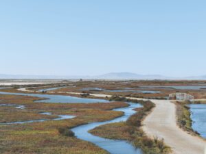
The air over Cullinan Ranch is cool and moist. Only the faintest gray line marks the location, south across San Pablo Bay, of the East Bay hills. The wetlands here, just north of Route 37, bear imprints of human use. Power pylons cut across the plain toward a naval installation; a half dozen double-crested cormorants use one tower as a vantage point. To the north, the low domed structure of an air traffic control transmitter punctuates the flat expanse. Despite these industrial blemishes, the place is beautiful and full of life. From retired salt ponds grow a profusion of wine-colored dock flowers, dark against the dry summer grasses. The sky is light and filled with the wakes of birds and dragonflies. A crumbling bridge crosses China Slough, a lazy tidal tributary of the Napa River.
From the crest of the bridge, Marc Holmes, Director of Wetlands Restoration for The Bay Institute, gestures at the scene below. “Before people started filling in the baylands, this was all tidal marsh.” Paul Revier of Save The Bay asks Holmes how far the marsh extended before it was filled, and Holmes points at a row of low hills just south of Sonoma, at least five miles inland from where we stand. We are five miles out to sea on the ancestral bay, Holmes explains. “I call today’s Bay the ‘Triple-A Bay’: its outline is so familiar from road maps. It’s startling when you realize just how much bigger it used to be.” A northern harrier swoops low and wobbly toward Petaluma. We gave northward across diked hayfields, momentarily silent, imagining what the scene would be like if someone restored the marsh.
More and more people around the Bay are working to do exactly that. Restoration of former wetlands is often a lead story on the local TV news. Military bases and aging salt extraction ponds are being considered for rehabilitation into tidal marsh, as are marginal agricultural tracts like Cullinan Ranch, bought a decade ago by the Fish and Wildlife Service for eventual restoration. The National Audubon Society has proclaimed the restoration of 100,000 acres around the Bay as a national priority for the organization. Even politicians and developers are jumping on the bandwagon: San Francisco International Airport has offered to underwrite the purchase and restoration of Cargill’s South Bay salt ponds, the largest remaining stretch of bayshore capable of supporting tidal wetlands. (Restoration of the salt ponds has been a longstanding goal of Save The Bay and other conservation groups. They are nonetheless suspicious of the airport’s offer of funds, seeing it as part of the campaign to build a new runway, a project that would require filling 1,200 additional acres of the Bay with more than 90 million cubic yards of earth, enough to fill 3-Com Park 36 times.)
Federal and local agencies, businesses and landowners, and engineering firms and environmental groups are all coming together to discuss the restoration of virtually every feasible stretch of bayshore through a cooperative partnership called the San Francisco Bay Joint Venture (SFBJV). The Joint Venture’s partners are involved in over 150 wetland and creek habitat projects around the Bay Area and have recently completed a strategic plan for the restor­ation of wetlands and wildlife called “Restoring the Estuary.” A further shot in the arm comes from the Estuaries and Clean Waters Act, passed by Congress in October 2000, which allocates $275 million over five years for watershed restoration nationwide. With the confluence of these factors, Bay Area residents have an unparalleled opportunity to protect remaining bayland from further destruction and to begin to undo some of the damage. But undoing that damage may be trickier than we think: if we rush to trade brand-new wetlands for expanded runways and other bayside development, we may wind up compounding the errors committed by our forebears over the last two centuries.
BEFORE THE “AAA” BAY
When scouts from Gaspar de Portolá’s 1769 expedition crested Sweeney Ridge above present-day Pacifica and became the first Europeans to see San Francisco Bay, that “immense arm of the sea” before them was very different from the Bay we know today. At high tide, that Bay was about 300 square miles larger than today’s. Not entirely coincidentally, 300 square miles is the amount of tidal marsh that’s been lost since.
Most of that loss has occurred in the last 150 years. From the Gold Rush through the twentieth century, Californians turned wetlands throughout the state into dry land in an orgy of diking and filling, referred to as “reclamation.” A 1959 Army Corps of Engineers map, “Areas Susceptible of Reclamation in San Francisco Bay Area,” [sic] shows the Bay that could have been. In this scenario, the dazzling estuary has become a mere slough, five miles wide off San Bruno and narrower elsewhere. A straight line from Vallejo to San Rafael would mark the north shore of a truncated San Pablo Bay. Berkeley would extend within a mile of Treasure Island. The San Mateo Bridge would cross about a mile of channel. The shimmering expanse of the Bay would be little more than an urban industrial sump, about as broad and appealing as the Hudson River off Tenafly, New Jersey.
Fortunately, this nightmare was forestalled due to a burgeoning awareness of the value of the Bay and its wetlands. Though there has been dissent from business interests who cite clogged freeways and delayed planes as a likely consequence of “locking up” the shore, most Bay Area residents now support the idea of restoration.
Probably no one expects to recreate the landscape Portolá saw, with grizzlies eating beached whales and pumas stalking tule elk in sloughs lining the edges of the Bay. Restoration of the modern Bay will necessarily come in bits and pieces, despite regional strategies such as those embodied in the Joint Venture. With enough fragments of restored marsh, the theory goes, endangered animals will find sufficient habitat to survive in a modern age.
The tricky part, it turns out, is getting the marshes restored.
NATURE KNOWS BEST
In 1994, work began on 300 acres of diked farmland some 10 miles west of Cullinan Ranch—dubbed the Sonoma Baylands—to restore the land to tidal marsh. The Sonoma Baylands project was a joint venture of a handful of state and federal agencies, the Army Corps of Engineers, and local environmentalists.
Marsh soils shrink and subside as they dry out. Letting the tides back into diked baylands often creates ponds rather than marshes, until sufficient tidal sediments build up over the seasons to allow marsh plants to colonize the restored baylands. At Sonoma Baylands, the land was filled with dredged material from the Port of Oakland, an attempt to give the process of sedimentation a head start. Then, in 1996, levees surrounding the site were breached to allow the tide to bring in more sediment.
Within two years, however, some observers began to argue that the marsh wasn’t growing (vegetating) at the rate they’d expected, though others maintained that the project—always intended as an experiment—was on schedule. By late 2000, some native cordgrass had started to grow, yet most of the site was still open water. This is most likely due to restricted tidal access. Some activists charge the mouths of the project’s channels were too narrow, and that the channel should have been widened artificially to let in more sediment, more quickly. The project’s designers assumed that tidal action would erode and broaden the channels over time, a process that is, in fact, taking place, if more slowly than some had hoped.
Few would argue that the land would have been better left diked. The sheltered lagoons provide a quiet place for ducks and migrating pelicans. Wildlife biologists colorfully refer to such places as “loafing habitat,” where birds conserve energy for migration or breeding.
And the story isn’t over yet. Sediment accumulates just fine in nearby North Bay backwaters: the Port Sonoma marina astride the nearby Marin-Sonoma line spends a significant sum each year just to dredge such sediment from its channels. In time, sedimentation may still build tidal marsh at Sonoma Baylands.
If it’s too long in coming, though, the marsh may be very different from the one planned for.
ARROWHEAD, THE ACCIDENTAL MARSH
One of the Bay Area’s most successful marsh restoration sites may have gotten its start by accident. No one knows for sure how Arrowhead Marsh, in San Leandro Bay near the Oakland Airport, was created. It wasn’t there in 1855: a shoreline survey that year mapped open water where there is now a thriving tidal marsh community. Sometime between that survey and 1895, a wedge-shaped finger of tidal marsh—the “arrowhead” the marsh is named for—grew into San Leandro Bay at the mouth of San Leandro Creek. According to Christopher Richard of the Oakland Museum of California, the person most likely responsible was Anthony Chabot, an engineer who had revolutionized hydraulic mining in the Sierra Nevada.
In 1874, Chabot used hydraulic techniques to scour the banks of San Leandro Creek in the hills above what is now Castro Valley. Much soil was carried downstream, but enough clay stayed in the creek bed to make an earthen dam. Lake Chabot began to back up behind it. That winter, heavy rains breached the dam, dumping an additional 21,000 cubic yards of clay into the creek. The arrowhead, at the mouth of the creek, was probably built from this soil.
Its mysterious and haphazard origin notwithstanding, and despite the industrial surroundings, the marsh—now part of Martin Luther King Jr. Shoreline Park—is a unique and thriving place. Here, patient visitors may get a good look at the endangered California clapper rail. Rails aren’t the only birds using this marsh: stilts, avocets, golden eagles, and burrowing owls use the area, as do thousands of migrating ducks. The Golden Gate chapter of the Audubon Society has embarked on a yearly census of the marsh’s bird population and sponsors frequent birding trips here. “Restoration remains an experiment in artistry rather than a scientific process,” says Arthur Feinstein, director of Golden Gate Audubon. “At Arrowhead, we don’t know whether the artistry is successful, but the birds sure love it. Even though we may not get what we hoped for, we certainly get something useful to some wildlife.”
Arrowhead Marsh’s apparent success belies a deeper threat. Most of the cordgrass that shelters Arrowhead’s rails isn’t the native Pacific cordgrass (Spartina foliosa), but rather a hybrid of the native with an exotic East Coast species, smooth cordgrass (Spartina alterniflora). Restorationists and wildlife biologists fear the invasive hybrid, and with good reason. Unlike the native species, the hybrid tends to colonize pickleweed habitat, home to the endangered salt marsh harvest mouse, and mudflats, a crucial feeding habitat for resident and migrating birds. The invasive cordgrass forms denser and more extensive thickets than the native, with an as-yet-unknown effect on wildlife. Rails do nest in thickets of exotic cordgrass and may benefit from the relatively higher numbers of marine invertebrates the thickets support. A marsh thoroughly colonized by exotic cordgrass is still immeasurably more valuable to wildlife than a parking lot or a runway. However, the speed at which Spartina alterniflora and its hybrids have invaded restoration sites throughout the Bay causes sharp concern among restorationists, especially as the only effective control seems to be through chemical herbicide use.
BAIR NECESSITIES
Bair Island, east of Redwood City, is still largely free of exotic cordgrass—for now. At 3,200 acres, Bair actually comprises three islands separated by tidal sloughs. Joggers and dog-walkers frequent the levees ringing Inner Bair. Aside from the occasional powerboat, the ubiquitous high-tension lines, and the frequent SFO-bound jets overhead, the rest of the tract is largely devoid of human presence. A host of skittish and endangered animals takes full advantage of this situation. Corkscrew Slough, which winds between Outer and Middle Bair, is an important haulout spot for harbor seals. Clapper rails, least terns, and peregrine fal­cons also frequent Bair Island. From any vantage point on the ground, the Island seems to stretch to the horizon: large enough that the word “wilderness” almost seems apt. Watching the island’s skeins of cormorants and gulls, it’s possible to imagine the far more immense flocks that landed here two centuries ago.
In the 1980s and ’90s, Kumagai Gumi—a Tokyo-based real estate development firm—threatened to develop Inner and Middle Bair Islands along the lines of neighboring Redwood Shores. Home to Oracle Corporation and DHL, Redwood Shores is an unremarkable upscale suburb on bay fill, with streets named after the shorebirds that no longer live there. Bair Island was spared this fate by environmentalists who waged a successful campaign to block the project and then lined up funding from several sources to buy the land. Twenty million dollars later, the U.S. Fish and Wildlife Service took possession of the tract, adding it to the South Bay’s Don Edwards National Wildlife Refuge.
Despite a century of use as cattle pasture and salt evaporator, Outer Bair still supports some native tidal marsh. If the spread of exotic cordgrass can be slowed, Outer and Middle Bair’s marshes may be relatively easy to restore. Inner Bair will be less so: the land has subsided markedly, increasing the risk that it will turn into duck ponds, which makes the operators of the adjacent San Carlos Airport understandably nervous. Despite the need for careful study of the invasives issue, activists are pleased the land has been preserved and are optimistic about its future. In the vision of Florence LaRiviere of the Citizens’ Committee to Complete the Refuge, “My hope is that Bair Island is the beginning of tidal marsh restoration in the South Bay that will eventually see the recovery, and subsequent delisting [from endangered species status], of the salt marsh harvest mouse and the clapper rail.”
SAVING THE “BLUE BELT”
Even the most straightforward restoration projects may face unforeseen obstacles. After 150 years of human use, and with hundreds of competing land use claims over each tract in question, the politics of restoration can be as slippery and confusing as the sloughs that wound through the historic tidal marshes.
But whether you’re dealing with politics or science, land is far harder to restore once malls or runways are built on it. This decade holds great opportunities to acquire and preserve huge stretches of restorable marsh, from decommissioned military bases, such as Hamilton and Alameda, to the vast South Bay salt ponds of Cargill and Leslie. If there’s a lesson to be learned from the fight to save Bair Island, it’s that people can change the future of huge pieces of the landscape if they set their minds to it.
Once we preserve that land from development, we’ll have time to determine the best ways to restore marshes from San Jose to Cullinan Ranch. Given the complex science involved, restorationists can be excused for treading cautiously on the tremulous Bay mud. Still, Sonoma Baylands and Arrowhead Marsh suggest that there is value even in partially-restored baylands. As Save The Bay’s Paul Revier says, “The important thing is to secure these lands while we can. After all, the largest contiguous open space we’ve got left is not the ‘greenbelt’ in the hills but the ‘blue belt’ of the Bay, which is really our first line of ‘urban growth boundary’ defense. As long as there’s nothing built on top of these remaining open spaces around the Bay, we can take our time figuring out where to go from there.”
Why Wetlands are Valuable
Water supply
With continuing population growth and increasing pressure on water supplies, wetlands are essential for the recharge of both ground and surface sources.
Water quality
The cleansing capabilities of wetlands help to filter out chemicals and other water-borne pollutants.
Recreation and aesthetic values
Wetlands are areas of great visual beauty and provide open space for recreational pursuits, including fishing, boating, hiking, photography, and wildlife observation.
Habitat and food web support
Wetlands provide essential habitat for hundreds of plant and animal species, and serve as nurseries for nutrients that sustain fish and wildlife both locally and downstream.
Economic value
By performing functions such as flood control and water purification, and by providing jobs in recreation, ecotourism, and fishing, wetlands are responsible for millions of dollars in economic benefits for California communities.
Source: Save The Bay, 2000