.jpg)
Three hundred years ago the waters of the largest estuary on the Pacific Coast teemed with life, from its narrow, shallow southern tip up to the vibrant delta—confluence of two great rivers flowing from the Central Valley. Whales and harbor seals, guided only by the season and ocean tide, fed off the plentiful fish that swarmed the Bay in dense runs.
Sea otters rolled along the shoreline, feasting on crabs, abalone, oysters, mussels, and clams. The phytoplankton and the tiny worms, snails, and shrimp-like creatures proliferated as the winter snowmelt and rain ran unfettered through the delta and out to the ocean. The underpinnings of the natural system were the hundreds of miles of mudflats and slough-crossed cordgrass and pickleweed marshes that provided a rich habitat sustaining millions of ducks, geese, and shorebirds on their spring and fall migrations.
Malcolm Margolin’s 1978 classic The Ohlone Way tells of a people who thrived by moving around this rich and ecologically diverse Bay, gathering acorns, trapping and spearing salmon, hunting deer, popping open oysters and staying out of the way of the grizzly bear. More than 400 shell mounds around the Bay, some 30 feet high and a quarter of a mile across, document a 5,000-year history of people settled among the animals and plants that fed and sheltered them. Rivers and creeks flowed unchecked to the Bay, and the water table was so shallow, the Ohlones could dig their wells by hand. “Duck were so thick that an early European hunter told how “several were frequently killed with one shot,'” wrote Margolin. “The channels were alive with beavers and river otters in fresh water, sea otters in salt water. And everywhere there were thousands and thousands of herons, curlews, sandpipers, dowitchers and other shorebirds.”
The early Spanish missions and Mexican occupation put an end to the Ohlone way—and nearly all the Ohlone people. Yet San Francisco Bay remained relatively intact. Before Sutter’s discovery of gold in California, voyager Richard Henry Dana offered one last look at a virtually undisturbed estuary. Dana had dropped out of Harvard College in 1835 to sail from Boston around Cape Horn to San Francisco. Once here, he marveled at the magnificence of the Bay.
“If California ever becomes a prosperous country,” Dana foretold in his 1840 account Two Years Before the Mast, “this bay will be the center of its prosperity. The abundance of wood and water; the extreme fertility of its shores; the excellence of its climate, which is as near to being perfect as any in the world…all fit it for a place of great importance.”

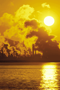
- The Tosco Refinery on the water in Martinez refinespetroleum products, such as the gasoline that powers our cars, trucks,and SUVs. Photo by Brad Perks.
With the Gold Rush came this new prosperity, but with it also came the seeds of the Bay’s near destruction. The new settlers began to transform the estuary by filling and diking the shoreline, shrinking the 787 square miles of open water and wetlands from the Delta to the Golden Gate by 239 square miles. They hunted and fed off wildlife, and logged redwoods for materials to build their cities. Plants and animals not native to the Bay arrived with the settlers. The newcomers used the Bay as a sewer and a dump, first just for garbage, but then, as the region became an important industrial and military center in the 1940s, as a receptacle for industrial chemicals and waste of all kinds. Around the same time, massive government water transfer projects diverted about 40 percent of the San Joaquin River and Sacramento River flows from the Delta for agriculture and cities in Central and Southern California.
By 1960, filling and dumping around the Bay was so common that most people didn’t even notice that the shoreline had become blighted with 41 smoldering garbage dumps. But three East Bay women—Sylvia McLaughlin, Kay Kerr and the late Esther Gulick—started comparing notes about the deterioration of the Bay they loved. The last straw was a U.S. Army Corps of Engineers map published in 1961 in the Oakland Tribune that showed what the Bay would look like in 2020 if development continued, eventually filling about 70 percent of the wetlands and shallow water. The resulting Bay would have been little more than a narrow channel surrounded by development. The three women banded together to form Save the San Francisco Bay Association. They lobbied, cajoled, organized, and got politicians to pay attention and pass laws. One of those laws spawned the Bay Conservation and Development Commission, an agency that was given the authority to approve, or deny, construction projects along the bay shoreline.
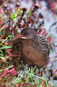
- A California clapper rail in pickleweed at the Palo Alto Baylands. Photo by Yoko.
In four decades, the “save-the-bay” movement has come a long way, from desperately warding off huge fill projects to proactively restoring large segments of shoreline. Dozens of groups have sprung up all around the Bay Area to advocate for, study, educate about, protect, restore, and enjoy the Bay. Their work has succeeded in raising the Bay’s profile and getting the media and government officials to pay attention.
In the mid-1990s, a number of Bay-related nonprofits, resource agencies, scientists, and businesses came together as the San Francisco Bay Joint Venture to map out a common effort to “undevelop” the Bay, to return to nature nearly half of the ancient tidal marshes. As of 2003, about 40,000 acres of shoreline property have been acquired, a big step toward the ambitious goal of adding 60,000 acres of tidal wetlands around the Bay. That would bring the total to 100,000 acres, equal to the size of 100 Golden Gate Parks. But restoring the Bay only starts with bringing back its shoreline habitat. The Bay may look fine on the surface, but what is going on underneath?
The Bay is still far from being a healthy body of water. Just consider the state’s warning against eating striped bass and shark from the Bay or more than two meals per month of any Bay-caught fish. Toxic chemicals from industry and agriculture are still dumped into the Bay—some legally, some not—at alarming rates. Fresh water from the mountains that could help flush out pollutants and provide improved habitat for fish is siphoned off to feed the demands of agriculture and urban users. Decades of overexploitation of native species and the introduction of nonnative exotics have altered the whole biotic community of the Bay, perhaps irrevocably. So the question arises: What kind of Bay is being saved? What constitutes a healthy Bay? How can Bay Area residents understand all the factors that are impacting the Bay—including what we do in their daily lives—and figure out what is helping and what is hurting? Can the Bay ever be a vibrant integrated ecosystem again?
The good news is that an impressive array of scientists and organizations and agencies is now looking at these questions and collecting the data necessary to answer them. The San Francisco Estuary Institute develops the Regional Monitoring Program to assess the presence of pollutants in the Bay. The California Academy of Sciences collects invertebrates to develop a comprehensive database of Bay fauna. The Point Reyes and the San Francisco Bay Bird Observatories chronicle how birds use wetland and salt pond habitats. The U.S. Geological Survey and the U.S. Fish and Wildlife Service study the effects of contaminants on organisms, including endangered species. The bad news is that the challenges are enormous, funding is tight, and time is precious. However, based on what scientists have learned so far, it is possible to identify the fundamental areas of concern and sketch out the primary challenges in each:
Habitat Loss: The recent purchase of 16,500 acres of former Cargill Corporation salt ponds—and 15,000 acres elsewhere around the Bay in the past four years—marks the halfway point towards the goal of reversing decades of habitat loss and bringing back 60,000 acres of tidal marsh. But the science of restoration is in its infancy and figuring out what works and what doesn’t will take immense quantities of research, dollars, and patience.
Pollution: Excessive levels of several toxic chemicals, including mercury, PCBs, DDT and other pesticides, impair the Bay’s water quality. These long-lived pollutants, which can damage the nervous systems of humans and wildlife, have contaminated fish and birds. Mercury continues to flow to the Bay from mercury mine leakage and debris in the watersheds. PCBs are known to persist in the environment for many decades, and a whole new class of chemicals, PBDEs, is being registered in rising amounts.
Freshwater Flow: The Bay is getting on average only 60 percent of its original freshwater flows from the Delta, and studies show that both abundance and diversity of native fish populations are declining as a result. Political realities say that the Bay will never see that level of fresh water again. But given those political constraints, what level of flow, at which times of year, would be required to sustain healthy populations of the remaining native fish of the estuary, such as salmon, steelhead, smelt, sturgeon, and herring?
Invasive species: Exotic organisms keep entering the Bay, while existing ones have already changed the Bay profoundly, transforming its wetlands and biotic systems. Continuing research into different methods of controlling these species is critical to the survival of the native bay ecosystem.

- The diminutive Delta smelt has changed the way water in the Delta is managed. Photo by Barrie Rokeach.
Those who work to restore native species, preserve wetlands, enhance water flows, and curb pollution look beyond the current state of the Bay as they ponder these questions. They dream of a place where people can once again look up at a sky thick with geese, herons, curlews, and sandpipers, and down into a Bay flush with fish that can be eaten safely by humans and seals alike. Sea otters will crack shellfish in the central Bay, while beavers and river otters abound in the channels. Chinook salmon will again gather en masse outside the Golden Gate, awaiting the rush of fresh cold waters to return home to spawn.
Is it a dream? Sam Luoma, a senior research hydrologist with the U.S. Geological Survey currently in London studying international scientific approaches to environmental pollution under a Fulbright Distinguished Scholar Award, was the first lead scientist for the CALFED Bay-Delta Program. He doesn’t expect a return to the world of the Ohlone. “But we do know that the environment will respond in positive ways if humans take the right actions,” he says. “How much restoration of ecosystem processes and threatened species is possible? The best approach, in my view, is to first reverse the trajectory toward an ever-worsening environment.” The next step, he says, is to see how the environment responds: “The earth’s ecosystems evolved through ever-changing forms over billions of years. With time, ongoing investment, and persistent dedication to sustaining a diversity of life, we might be surprised by what Mother Nature will deliver back to us.”