Correction: An earlier version of this story used the San Francisco Airport rainfall record for 2020, which has recorded less rain than downtown San Francisco. While SFO has only recorded 4.6 inches of rain to date, the long-term historical record uses downtown San Francisco, making 2020 more likely to be the second-driest year in recorded history there.
It’s probably not the first thing that will come to mind when you think back on this year, but 2020 is now on track to be the second driest calendar year in San Francisco in recorded history — dating back 170 years to 1850.
Water managers track a water year from July to June, so depending on what happens this winter, it might not set any records. It might even end up as an overall wet winter! “You can’t necessarily draw conclusions on November 23,” said National Weather Service meteorologist Ryan Walbrun. “Honestly, it’s too early to kind of throw up the flag or whatever.”
But let’s draw some conclusions! The driest January to December period in San Francisco history was in 2013, when the city recorded 5.59 inches of rain, according to an analysis of records kept by Jan Null’s Golden Gate Weather Services. The second driest was 1917, with an even 9.
After a record-setting fully dry February and below average spring and summer, a shutout October and single weak storm in normally rainy November, downtown San Francisco has recorded 5.7 inches of rain so far in 2020, according to NWS data. While the average for December in San Francisco is around 4 inches, there’s also no rain in sight through the first week of the month. All of Northern California is now in some kind of drought, according to the federal Drought Monitor, with the Bay Area in “severe” drought conditions and much of the Coast Range and Central Valley in “extreme” conditions.
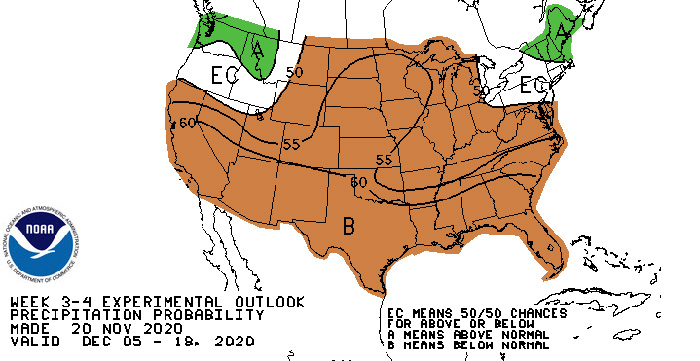
The National Oceanic and Atmospheric Administration’s 3-4 week precipitation probability outlook, covering the first half of December, looks like this:
Walbrun said not to panic: San Francisco is part of a narrow Central California band that’s been extremely dry, but other parts of the state are doing better in a reasonably typical La Niña pattern. It’s raining in the Pacific Northwest and there’s been some snow in Tahoe. The jet stream that ushers storms across the Pacific has been flowing north of the Bay Area for the last few weeks, but it’s reasonable to think it’ll move south in the core winter months, Walbrun said. It’s nothing like the worst year of the last drought, 2013, when a stable persistent ridge parked itself over the North Pacific and blocked storms all winter.
“At this point we are in a typical transition season, and at least the overall jet and pattern is somewhat active,” Walbrun said. “So we’re not sitting in some stable regime where there’s just a ridge with no hope of rain.”
Anyway, I hope writing this post works as a reverse-jinx and a bunch of storms show up in December. In the meantime: