.jpg)
If you travel east over the Richmond-San Rafael Bridge, you may catch a glimpse on the left of a red brick castle in the middle of a green swath of oaks, bay, and coyote brush. That building marks Point Molate, a modest blip of land on the Point San Pablo peninsula that until last year was almost unknown to most people in the Bay Area.
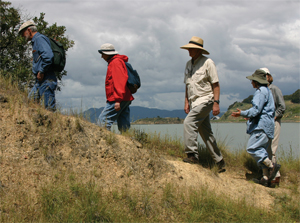
So when environmental biologist David Amme planned an April hike to the few “postage stamp remnants” of native prairie left on the Point San Pablo peninsula, he expected a handful of members of the California Native Grasslands Association and a few dedicated amateur botanists. He was startled to find confirmation calls piling up in his answering machine like commuter traffic on Highway 80. Since last fall, when the City of Richmond announced plans to sell the land to a casino developer, Point Molate has become, Amme says, “a cause celebre.”
It should be. The view from a shoreline bluff just north of the embattled point is everything Amme promised: a sparkling expanse of blue water, the San Rafael bridge slithering across the Bay like a silver dragon, and the craggy Marin coast beyond. The curve of the Potrero Ridge behind you hides the presence of the huge Chevron refinery on the opposite side, along with the press of urban culture that Point Molate has eluded for the past century.
“You have here five miles of undeveloped shore, one of the last accessible bayside landscapes in the East Bay,— Amme says to the assembled hikers. “There are spots with tremendous native wilderness, with incredible native grasslands, the last piece of coastal terrace prairie within the Bay, and picture-perfect views of Mount Tamalpais.” Elusive, overlooked, and now contested, Point Molate is a place whose past is finally gaining wider attention, while its future remains up for grabs.
Amme wants us to appreciate Point Molate’s present-day flora, but to do that, we’ll need to understand its ancient history. As he’s fond of saying, what’s below ground is probably even more important than what’s above-and the earthly foundation that determines the ecological character of this place has been building for about 75 million years. The rock underlying the Point San Pablo peninsula is a geologic layer cake of sandstone and shale known as Novato Quarry terrane. It’s evidence of a shared ancestry with the hills on the other side of San Pablo Strait in Marin County. A mere million or two years ago, the subsurface rumbling that defines the Bay Area pushed and folded the rock into ridges, while the steady etching of ocean-bound streams separated forever the points of land at the mouth of San Pablo Bay.
“If you look on a map, you’ll see Point Molate is part of a long peninsula that lines up with the hills above McNears Beach and China Camp,” says geologist Doris Sloan, of the University of California at Berkeley. “Probably at one time they were connected, and the rivers that came through the Carquinez Strait eventually cut through, around 620,000 years ago.” (The strait is the narrowest point in the whole Bay, forming the dividing line between San Pablo Bay and central San Francisco Bay.) Perhaps in recognition of their kinship, the points were dubbed San Pedro and San Pablo-Saint Peter and Saint Paul.
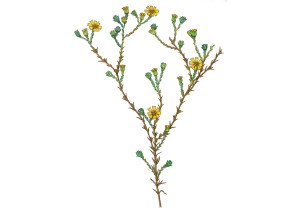
When the ridges were young, they supported a coastal prairie that included a number of now-uncommon native grasses such as purple needlegrass, Diego bentgrass, California oatgrass, and a unique form of red fescue dubbed “Molate fescue.” Some are found only in this area and-you guessed it-across the bay near China Camp. A number of other plants, such as California pipevine, coast buckwheat, and narrow-leaf mule-ears, are limited in the wild to fewer than a handful of locations in the East Bay. In fact, the coastal prairie ecosystem, once common all along the eastern shore of the Bay, now hangs on in only a few spots, including here on the Point San Pablo peninsula.

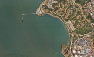
- The casino controversy has brought unprecedented public attention toa once-obscure landscape. An April walk organized by grasslands expertDavid Amme attracted dozens of people to Point Molate. Photo by Sarah Bettelheim
.
Herds of elk, deer, and antelope once made their homes on these slopes and supported a number of carnivores-grizzlies, mountain lions, bobcats, and wolves. At the foot of the Potrero Hills, coots, wigeon, sandpipers, and canvasbacks flew and fed among abundant eelgrass growing in the Bay’s shallows. Such well-provisioned territory no doubt attracted Point Molate’s first inhabitants, the Huchiun group of Ohlone Indians, who probably arrived around 5,000 years ago. Except for a few shellmounds and middens, they left little behind to tell of a few thousand years of fairly peaceful existence. In 1823, Don Francisco Castro, one of the first nonnatives to explore the area, became owner of 17,000 acres of it via a Mexican land grant.
Beginning in 1870, after Castro’s ranch was cut up by his heirs and various squatters, Chinese shrimpers moved in to set up a camp near Point Molate beach, sister to a similar enterprise across the water at Point San Pedro. Using bag nets, they trawled the Bay for shrimp to dry for export to China. The industry’s growth illustrates the Bay’s pre-urban bounty: by the end of its 20-year run, the operation (part of San Francisco’s Union Shrimp Co.) had grown from 40 shrimpers to 100 and boasted five wharves and 110 shrimp boats. The shrimp camp closed after laws passed from 1912 to 1915 banned the use of bag nets, a fishing technique used almost exclusively by the Chinese.
Standard Oil Company bought 500 acres of land on the east side of the Potrero Ridge in 1901 and completed its Richmond refinery a year later (the company became Chevron in 1984). The refinery anchored Richmond’s industrial-agricultural landscape until 1906, when a new wave of settlers arrived at Point Molate after San Francisco’s earthquake and fire. The California Win-eries Association (CALWA)-a conglomerate of winemakers, distributors, and vineyards-lost 10 million gallons when its San Francisco cellars burned, so the operation moved to Point Molate in 1907. To house its shipping and bottling operation, CALWA built a brick-clad fortress that would defy tremor and flame: The huge Winehaven building, visible from the San Rafael bridge, resembles a Gothic castle with its bartizan towers and crenellated parapet.
Sheltered by the Potrero Ridge, near sea and rail, Point Molate was an ideal location for a worldwide operation: Grapes from Napa Valley were unloaded from CALWA’s pier; the finished barrels of wine were shipped nationwide by rail. Eventually, Winehaven (once described as “the largest winery in the world”) constituted a self-contained community-the village of Point Molate. A string of 29 cottages along what is now Western Drive housed workers’ families; bachelors slept in bunks on a barge anchored by the pier; children attended the school; and tourists stayed in a hotel perched above the winery.
A few years after Prohibition in 1919, Winehaven was abandoned; then, with the advent of World War II, the Navy enlisted it as a fuel depot. Heavy machinery rolled over the stands of coastal prairie and oak woodland, digging large pits for 24 underground fuel tanks. The old “castle” became fuel storage, and children filled the Winehaven school again.
Point Molate has remained a well-kept secret for most of the years since. The fuel depot was decommissioned in 1995, and Richmond later purchased the land. For the past decade, the $80 million job of cleaning up 60 years of toxic fuel storage has kept the land off-limits to casual visitors.
“Most people hadn’t been paying attention,” says Bruce Beyaert as he navigates a twisting road to the ridge above Point Molate. “It [was] an isolated place, terra incognita, until the casino deal was announced.” Permission to pass beyond the site’s warning signs and fencing required a series of phone calls to several city departments and an appointment with Willie Agnew, the gatekeeper who’s kept a rather lonely vigil at Point Molate for the past six years. Agnew is more than happy to leave his unheated concrete office to lead a morning’s exploration of Point Molate.
Beyaert is chairman of Trails for Richmond Action Committee (TRAC) and former member of the Point Molate Restoration Advisory Board (RAB), which keeps tabs on the cleanup and environmental preservation work on the site. He’s come to know Point Molate well since his appointment to the Blue Ribbon Advisory Committee (BRAC), a 45-member group convened in 1994 to study reuse possibilities for the 413-acre site (of which 290 are above the mean high-tide line).
Noting that Point Molate is “one of the few places in the San Francisco Bay Area where undeveloped hillside interfaces directly with the waterfront,” the BRAC’s Reuse Plan set aside two-thirds of the site’s dry land as open space, including a shoreline park and a 1.4-mile piece of the Bay Trail. To pay the costs of maintaining the site, the committee envisioned a Fort Mason-like complex of live/work housing, performing arts and conference centers, restaurants, a restored winery, a job training facility, and a museum. The reuse plan, Beyaert says, would allow commercial and light-industrial use while treading lightly on the 40-acre shoreline park and the 156 acres of land on the steep, 480-foot-high slopes of the Potrero Ridge, which are too rugged to be developed anyway.
The remaining 90 acres of flat terrain has been quarried, exhumed, and carved into roads, catch basins, and drum storage areas. A 1,200-foot pier juts from the shoreline. Catch basins store poisonous runoff. But on this fine spring morning, Beyaert points out features of the land peeking out from beneath the surgical scars of years of mechanical rearranging—glimpses of the beauty Point Molate once displayed.
Below, off Point Molate beach, lies what Beyaert calls “the mother of all eelgrass stands”—one of the five largest in the Bay Area, according to a 1999 assessment. The habitat provides food, shelter, and spawning grounds for Pacific herring and juvenile Dungeness crab; young salmon, striped bass, steelhead trout, and starry flounder feed on the invertebrates hidden in the eelgrass. The small fish are lunch for the endangered least tern and dozens of other bird species. On the hillsides above, native coast live oak, coyote brush, toyon, and coffeeberry confront an alien invasion of eucalyptus, pampas grass, and other species. Beyaert’s car rolls through stands of French broom so thick they seem to part like the Red Sea to allow the narrow remaining strip of cracked asphalt to sneak through.
The broom is a reminder that Point Molate’s ancient habitat has been unalterably transformed by human presence-but surprising numbers of larger mammals and raptors don’t seem to mind. The coastal scrub and nonnative thickets support black-tailed hare, striped skunk, raccoon, a mule deer herd 50 strong (“one of the few remaining stable populations within the City of Richmond,” according to the Reuse Plan), and even gray fox and coyote. Red-tailed hawks, kestrels, and black-shouldered kites forage the grasslands, and great horned owls nest in the empty Winehaven buildings.
It’s hard to picture a 150,000-square-foot Harrah’s resort casino, 400-room and 700-room hotels, a shopping mall, and parking for 3,000 vehicles in the middle of this untamed place. As drawn in the present proposal, the Bay Trail wanders through a wing of one hotel, under a breezeway that butts against a bluff where rare prairie grasses now grow. And what might happen to the open space once it’s sold to new owners is anyone’s guess.
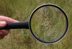
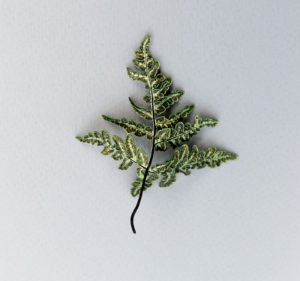
- The San Pablo peninsula’s coastal prairie is home to a unique formof red fescue, dubbed Molate fescue. Coastal prairie, once common inthe East Bay, now persists in a few remnants here and at the nearby UCRichmond Field Station. Photo by Sarah Anne Bettelheim.
Yet Beyaert is reluctantly practical. “There was a time when the city was ready to say no to the Navy,” he says. “Fortunately, the city didn’t deny the opportunity to acquire Point Molate, but without economic resources, there’s no way they can take care of the [historic] buildings. No public agency has been willing to step up and commit the resources. East Bay Regional Parks had a plan for a shoreline park, but never had the money to do it. Meanwhile, the casino folks say they will build and maintain the Bay Trail and 40 acres of shoreline park. It’s sad that no one else has stepped forward.”
Don Gosney, a member of BRAC and cochair of the RAB, believes the casino development proposed last year by the Guideville Band of Pomo Indians and developers Upstream Point Molate LLC is a reasonable echo of the Reuse Plan. “The casino is the financial engine that will drive the project. We’re talking 6,000 union jobs, 3,500 subsidized jobs, and a community’s sense of pride. The contract with the tribe requires $18 to $20 million in fees in lieu of taxes,” he says. “Congress requires any public use there [to] be self-supporting. How many people visit Point Molate now? Twenty a month? To make a park there self-supporting, you’d have to charge a $200 entrance fee.”
Since the casino plan was announced last fall, a number of entities have come together as somewhat surprising allies against it. Last August, the Sierra Club, East Bay Regional Parks District (EBRPD), and Citizens for the Eastshore State Park (CESP) teamed up to support Chevron’s offer to purchase the land. The company isn’t happy about the idea of thousands more people congregating near its refinery, but Chevron’s offer didn’t lay out any specific use for the land. After the city passed on that offer, EBRPD and CESP filed a lawsuit in December 2004, charging that Richmond did not properly observe California Environmental Quality Act guidelines before signing an agreement with Upstream.
“There should be economic development, but there should also be a priority on the shoreline park. Harrah’s is overwhelming that,” says Bob Doyle, EBRPD assistant general manager of the lands division. “They’ve put a hotel right on top of an important part of the shoreline, [which] becomes the hotel’s front yard landscaping.” In April, State Attorney General Bill Lockyer joined in the EBRPD lawsuit, adding the state’s legal muscle to the casino opponents’ cause. In May, the San Pablo Open Space Committee, which includes representatives from Richmond, Chevron, EBRPD, TRAC, the state Coastal Conservancy, and the Muir Heritage Land Trust, released a report calling for much of the San Pablo peninsula to be turned into public parkland. Under that study’s preferred alternative, private development at Point Molate would be held back from the shoreline.
As the lawsuit makes its way through the courts and the tribe and developers press their cause, Point Molate waits. From the wine master’s old house on the hill above the 29 cottages, the view remains spectacular. “When the sun is pretty,” Willie Agnew says, “you can see the Golden Gate Bridge and the Bay Bridge.” Plants are beginning to cover the scars where toxic soil was scraped from the hill’s surface. Native sun cups, poppies, lupines, and monkey flowers are making a stand in between the alien species. The top of the underground tanks are covering nicely with a concoction of indigenous perennial grass seed the Navy has dubbed “Beyaert mix” in honor of the man who insisted on the revegetation effort. “We brought ‘Point Molate’ red fescue back. It’s the real thing,” Beyaert says.
“What’s amazing is that Point Molate has gone from the largest winery in the West to a fuel depot to maybe a gambling resort,” he adds, taking in Winehaven, the pier, and the calm waves rippling to the horizon. “This place has gone through some incarnations. It boggles the mind.” Given all those incarnations, it would be wise to wait before betting on what happens next.