Estero Trail, January 28, 2012 (~10 miles, easy to moderate)
Conditions: Clear sky, temperature 60-72°F, negligible wind, low tide.
Route: Estero Trail to Sunset Beach (3.9 mi.); Sunset Beach to White Gulch Trail (2.9 miles); White Gate trail to Muddy Hollow trail (1.5 mi); White Gate trail end to Estero Trail head 1.6 mi): Total 9.9 miles.
Check out these and other hikes Jules has taken on this Google map. The most recent hike is in blue; others are in red.
On the trail
At the trailhead, a northern harrier lands on the fence post, a vole in its talons, and I remember what a raptor-rich area I’m entering. For the first quarter mile or so, the footpath circles a low knob through northern coastal scrub.
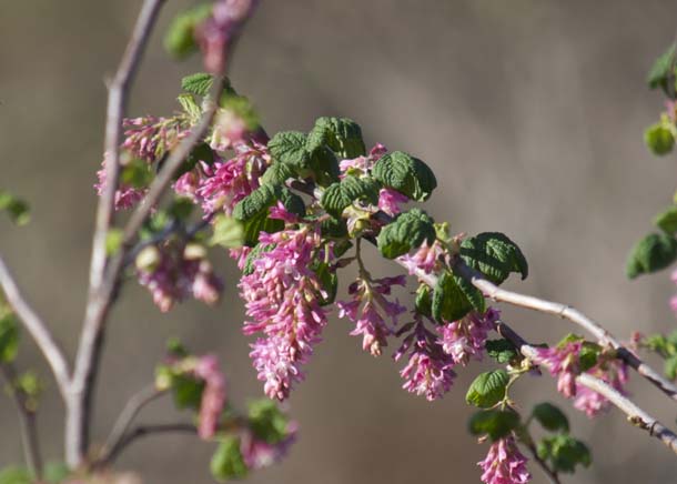
A flowering currant is in full bloom next to the trail, which seems early.

-
Flowering currant (Ribes sanguineum), “among the choicest of our early flowering shrubs” (Marin Flora). Photo by Jules Evens.
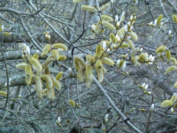
Having been raised in northern New England, a land of distinct seasons, I’m still awestruck by the protracted, overlapping seasons on the central California coast. It’s still January and already spring is busting out. (This morning as I left my house I heard the first Allen’s hummingbird I’ve heard since September, a bantam buzz-bomber that has just returned from its “wintering grounds” in Central Mexico. Two species of hummer are common here; the larger Anna’s is resident year-round; the diminutive Allen’s migrates south.) Farther along the trail a willow is already laden with catkins and the ground-hugging and aptly named composite “foot-steps-of-spring” (Sanicula arctopoides) has appeared along the edge of the trail
-
Flowering willow (Salix spp.), Estero Trail, January 28, 2012
As the path swings around the hillside, you come upon “The Christmas Tree Farm,” a 20-acre forest planted by the former owner before the park was established (50 years ago this year) to increase the value of the property before the purchase price was negotiated, according to local historian Dewey Livingston. The forest, dense and dark, seems out of place in contrast to the open grasslands and coastal shrub of the surrounding landscape. Now over a half-century old, the trees are quite large, approaching senescence, with many dead snags. An inspection of the needles of these pines shows that each bundle is made up of three long needles; the similar bishop pine would have only two needles per bundle. (A mnemonic for this distinction: “Monterey” has three syllables; “bishop” has only two.) Two hairy woodpeckers are calling back and forth, and several downy woodpeckers and many northern flickers are working the deadwood. Some years, when vole populations are booming, this large tract of pines serves as a day roost for parliaments of owls–particularly long-eared and barn owls–and a night roost for an “unkindness of ravens” (a phrase originating in British folklore from the belief that ravens pushed their young from the nest until the parent birds ‘saw what color they would be.’)
-
Footbridge crossing the Home Bay breach with the Monterey pines in the background. Photo by Jules Evens.
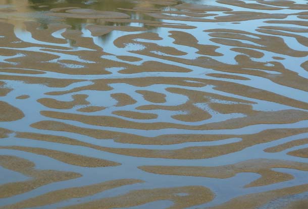
Beyond the Christmas tree farm, the trail crosses a levee in the toe of Home Bay, and a wooden footbridge crosses the levee breach. This bridge can be a good place to look down on bat rays, and sometimes leopard sharks, coming into the backwater on a rising tide, but this morning the tide is quite low; shorebirds are foraging on the exposed tidal flats and green-winged teal feed in the shallow channels.
-
Tidal flats provide rich foraging opportunities for shorebirds: although not visible in this picture, least and western sandpipers, dunlin, willets, godwits, and black-bellied plovers are common here from August through April. Photo by Jules Evens.
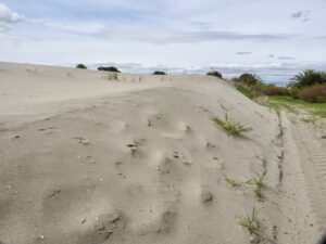
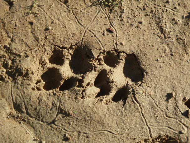
The trail beyond the levee climbs a gradual slope paralleling the shoreline. The south side of the trail has not been grazed, and is covered with a dense and diverse community of northern coastal scrub–coyote brush, sword fern, wax myrtle–a plant association that was common here before the introduction of cattle a few hundred years ago. California quail, Bewick’s wren, wrentit, spotted towhee, and white-crowned sparrows are characteristic birds in this habitat; brush rabbit, deer mouse, and gray fox the common mammals. At the top of the rise, a cattle gate must be unlatched and latched. You are now entering cow country; the landscape is worked, the trail pocked by hooves, the footing unstable. The recent rains have left clear impressions of passersby in the marl–the shod hooves of horses, cattle hooves, hiking boots, and apparently some hominoid has been running barefoot here recently. (Highly recommended read: Born to Run by Christopher McDougall.) Searching through the tracks I come upon some well-defined coyote tracks
-
Coyote tracks–when trotting or running, it is common for the hind print to land on top of the front print, as pictured here, and the front paw of the coyote is larger than the hind paw. Tracker-naturalist Richard Vacha suggests these are two right feet “judging by the asymmetry of the toes” and that the coyote was running in a “side-trot.” Photo by Jules Evens
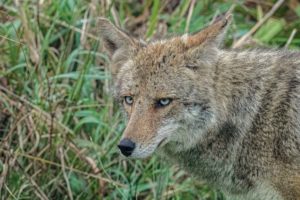
Coyotes have recolonized the peninsula over the last decade or two. They were indigenous here, of course, but were largely eradicated during the cattle period and have rebounded since the park was established. This “song dog of the west” inspires both love and hate in humans, but from an ecological perspective, the coyote is a keystone predator, one who keeps the community in balance. A seminal study in Southern California found that in large tracts where coyotes were absent, the songbird populations, especially of shrub and ground nesting birds, were much lower, with some species–like quail, wrens, and towhees–absent. The absence of coyotes causes “mesopredator release,” a population boom in smaller predators–opossum, raccoon, feral cats–that prey on songbirds and other small vertebrates. In areas where coyotes are present, these mesopredators are suppressed, or controlled, and the populations of songbirds and small mammals benefit. In short, a decline in dominant predators causes a “trophic cascade,” that is a change in relative populations of predator and prey that reverberates through the food chain. Here’s the paper if you’d like to go to the source. (Always a good idea!) Download the PDF.
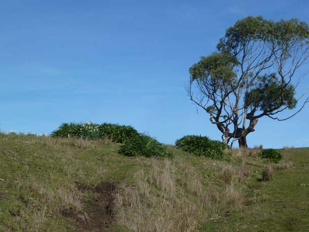
A bit farther along, the trail passes through grazed grassland and a round rise some jonquils are blooming and Agapanthus clumps are incongruously verdant amid the otherwise tan grasses and barren ground. This must have been a homestead at some point in the past. Back home, I ask Dewey Livingston what was here and he responds: “The old Berry Ranch occupied that site, although the oldest (1860s) location is not exactly known. They called the entire area Berry Point. In the 20th century, this spot was the home to both artichoke and pea farmers, the former being Italian immigrants and the latter first generation Japanese; both were gone in WWII.”
As Dewey points out, when WWII broke out, the Japanese were incarcerated in interment camps and (incredibly!) Italians were prohibited by law from venturing west of Highway 1. So, the earlier era of vegetable farming on the coastal plain at Point Reyes ended in the 1940s. It’s difficult to imagine these rolling hills–now a patchwork of pastureland and coastal scrub–cultivated with artichoke fields.
-
“Berry Ranch,” where non-native plantings reveal earlier human habitation. Photo by Jules Evens.
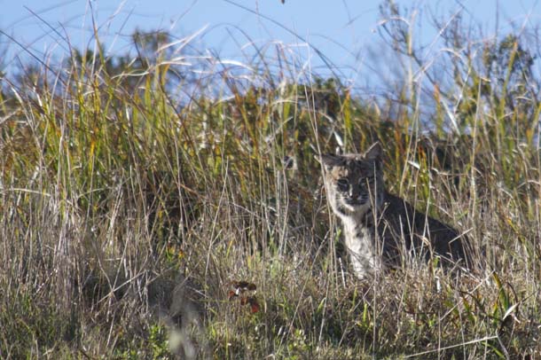
Through another cattle gate, into an area where cows have been fenced out and grazing pressure eliminated, the vegetation has reverted to coastal scrub and marshy swales. From a green spring covered with knee-high clumps of spiny rush (Juncus), I flush a bobcat that bounds up the slope then stops to stare me down. I think it’s a female, as she is on the small side. Bathed in sunlight, with a dispassionate feline expression, she seems unconcerned, closing her eyes, and scanning the surrounding shrub while I unpack my camera and take a few shots.
-
Bobcat on Estero Trail, January 28, 2012. Photo by Jules Evens.
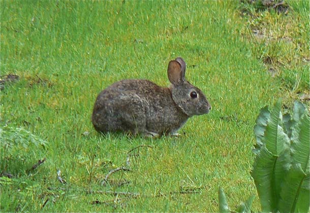
Like the coyote, the bobcat is a dominant predator here, and likely keeps the “mesopredators” in check. However, I suppose the main prey item here for bobcats is the brush rabbit, especially abundant in the coyote bush covered habitats. Indeed, a little farther along, on the spur to Sunset Beach, I find the fresh remains of a brush rabbit unfolded–rich brown fur and damp hide–on the side of the trail.
-
Brush rabbits (Sylvilagus bachmani), a small cottontail, are abundant residents of coastal scrub habitats and favored bobcat food; they rarely venture more than a hop or two shrubby cover. Photo by Jules Evens.
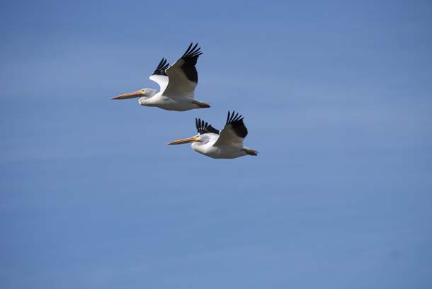
The tide has risen a bit and the flats are covered now. I scan the calm waters of the estero, and from this high bluff I can identify the larger waterbirds scattered across the water. A large flock of black brant, the elegant small sea goose, is grazing on the eelgrass beds. Eelgrass is their only source of nutrition in the non-breeding season, and its sparse distribution dictates their occurrence along the Pacific coast from Baja to Alaska. (More on brant in a walk to Bull Point in early April, when migrant flocks should build into the thousands.) An equally large group of American white pelicans is rafting on the open water. Some peel off from the flock and, after labored wingbeats, gain altitude and fly overhead en route to their traditional roost site, a sandbar at the mouth of the estero.

-
American white pelicans (Pelicanus erythrorhynchos) in flight over Sunset Beach. Photo by Jules Evens.
Unlike the brown pelican, which is strictly coastal, this ancient being spends only the winter season along our coast, migrating inland to breed on islands in saline lakes of the Klamath and Great basins. Sadly, the combined effects of drought and water diversion in the West have lowered water levels and the nesting islands have become connected to lake shorelines, affording access to coyotes and other predators. Also, water quality of inland foraging areas has been degraded by “high nutrient concentrations coupled with a loss of much of the natural filtering function of riparian and wetland habitats within the watersheds” (Dave Shuford in “California Bird Species of Special Concern.”) As a result of the decrease in nesting at inland sites over the past few decades, white pelicans have been spending more time along the coast, in some years remaining year-round, apparently foregoing nesting altogether. Indeed, most if not all the pelicans in the large roost (150 birds) at the mouth of the estero appear to be adults. Pelicans are a long-lived species, with a lifespan exceeding 20 years, but no natural population can survive the challenges pelicans are facing for long. So it goes.
-
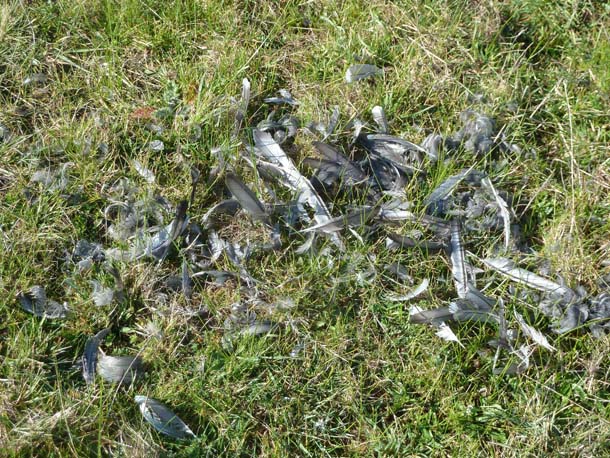
Remains of an American coot (Fulica Americana) Sunset Trail stock pond. Photo by Jules Evens.
The spur to Sunset Beach (1.4 miles each way off the Estero Trail) passes a freshwater stock pond just before reaching the shoreline. A few dozen white pelicans are bathing in the freshwater, and a pair of gadwall ducks, pied-billed grebes, and a few coots. On the edge of the pond a cluster of coot feathers suggests that the bobcat was stalking the pond earlier in the morning.
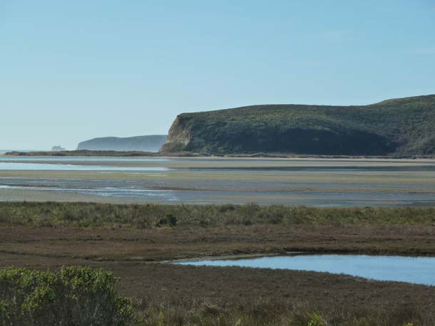
The bench at the end of the Sunset Trail provides a nice spot to have lunch and to look southwest, toward the mouth of the esteros, with a view of Chimney Rock and the outer point.
-
View of Chimney Rock from Sunset Beach, across exposed tidal flats. Photo by Jules Evens.
I backtrack along the Sunset Beach Trail to rejoin the junction with the Estero Trail and head easterly toward the Drake’s Head spur (0.6 miles). This section of trail crosses some terrain highly degraded by cattle, and the designated route is difficult to follow in places. Just when I think I’m off trail, a small sign with an arrow points me in the right direction. I don’t have time (or energy) to take the trail to Drake’s Head (1.7 miles each way), but make a mental note to return in the fall, when the overlook there provides fine views of leopard sharks that have entered Limantour Estero to breed.
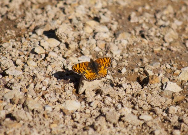
Near the junction of the Estero Trail and the White Gate trail a small, spangled, tiger-colored butterfly lands in the path. It is one of the difficult to identify checkerspots or crescents, but I have no idea which species. It rests long enough for a quick snapshot, and when I get home I go through my references trying to identify it. I also send the picture to butterfly experts, Paul Opler and Ken Davenport. Both agree it’s a Mylitta Crescent (Phycoides mylitta), one of “the commonest crescents in lowland California.”
But Ken responds that “it still makes history by beating the previous early flight for that species for California” and he will add it to next year’s list on The International Lepidoptera Survey website. So, perhaps the mild early winter hatched an early flight of this common species. Cold-blooded organisms are particularly sensitive to temperature increases and according to an article in Science Daily (March 18, 2010), earlier butterfly emergence has been linked to climate change. Not only are butterflies emerging earlier, their ranges are generally shifting northward and to higher elevations.
-
Mylitta Crescent butterfly (Phycoides mylitta), with a wingspan of about 1.5 inches. Jules Evens spotted this mylitta crescent butterfly on Point Reyes in January 2012, marking the earliest recorded sighting of this common butterfly in California. Photo by Jules Evens.
After a mile and a half, White Gate Trail joins the Muddy Hollow Trail and the fire road that loops back toward the Estero Trail head through Home Ranch. I’d walked this route before, but now there is a sign that the fire road toward the Home Ranch is no longer a designated trail and hiking and biking is prohibited. Bummer; the best laid plans of mice and men . . . I really don’t want to hike the extra few miles to Muddy Hollow and try to hitch a ride back to my vehicle, so decide to be a scofflaw and take the fire road. The folks at Home Ranch are old friends, and I don’t think they’ll get too upset with me for walking through the ranch. So, I walk the 1.7 miles back to the Estero trailhead. Others should not plan on this route. Better to take the Muddy Hollow road and leave a car at ether end.
Trail notes:
This circular hike totaled 10 miles and took about 6 hours, but I’m a slow poke on the trail, stopping to inspect tracks, identify plants, and photograph pelicans and bobcats.
The same route, but ending at the Muddy Hollow trailhead, would be a equivalent distance, but would require a vehicle at either end, or a prearranged pick-up at trail’s end. The first section of trail, from the parking lot and across the Home Bay footbridge is easy and well maintained. After crossing the levee, the trail follows a moderate climb up the bluff. Through the first gate you have entered cow country; the landscape is worked and the trail is uneven and quite slippery when wet for the next mile or so. Caution recommended. Farther along, the trail to Sunset Beach is easy. Where Estero Trail takes a sharp turn toward the Drake’s Head spur, the cross-country route can be confusing and sloppy in places. Watch for signs and arrows to guide you. To stay on designated trails, make this a one way trek to Muddy Hollow trailhead, 10 miles overall.
Wildlife Sightings
Butterflies
west coast lady
mylitta crescent
Amphibians
Pacific chorus frog
Birds
American coot
American kestrel
American pipit
American robin
American white pelican – 150
American wigeon
Anna’s hummingbird
belted kingfisher
Bewick’s wren
black phoebe
black-bellied plover
brant – 140
Brewer’s blackbird
bufflehead
bushtit
California gull
california quail
California towhee
Canada goose
canvasback
chestnut-backed chickadee
common loon
common raven
common yellowthroat
double-crested cormorant
dowitcher sp.
downy woodpecker
dunlin
eared grebe
Eurasian wigeon
European starling
fox sparrow
gadwall
glaucous-winged gull
golden-crowned sparrow
great blue heron
great egret
greater scaup
greater yellowlegs
green-winged teal
hairy woodpecker
hermit thrush
horned grebe
Hutton’s vireo
killdeer
least sandpiper
Lincoln’s sparrow
long-billed curlew
mallard
marbled godwit
mourning dove
northern flicker
northern harrier
northern pintail
northern shoveler
Nuttall’s woodpecker
osprey
peregrine falcon
pied-billed grebe
pine siskin
pygmy nuthatch
red-shouldered hawk
red-tailed hawk
ring-billed gull
ring-necked duck
ruby-crowned kinglet
ruddy duck
savannah sparrow
snowy egret
song sparrow
spotted towhee
Townsend’s warbler
turkey vulture
western bluebird
western grebe
western gull
western sandpiper
western scrub jay
white-crowned sparrow
willet
winter wren
wrentit
yellow-rumped warbler
Mammals
black-tailed deer
bobcat
brush rabbit
cattle (~200)
coyote (scat)
harbor seal
horse (2)
human being (15)
(mountain lion scat)
(raccoon tracks)