Tens of thousands of years ago, California’s Sierra Nevada Mountains wore upon their shoulders the ancestors of today’s rivers. The waterways flowed down from the highlands to meander across the plateau of the Central Valley in languorous braided ribbons. Spurred by sea levels about 400 feet lower than today and climate and glacial processes, the rivers cut valleys 100 feet deep and a mile wide through sediment on the valley floor, as runoff from glacial melt scoured the land, pushing downstream loosened gravel, sand, and silt. Later in the glacial cycle, as sea levels rose and the streams flattened out, they lost momentum. Gravel and sediment dropped out of the water column, backfilling the cut canyons with this coarse material.
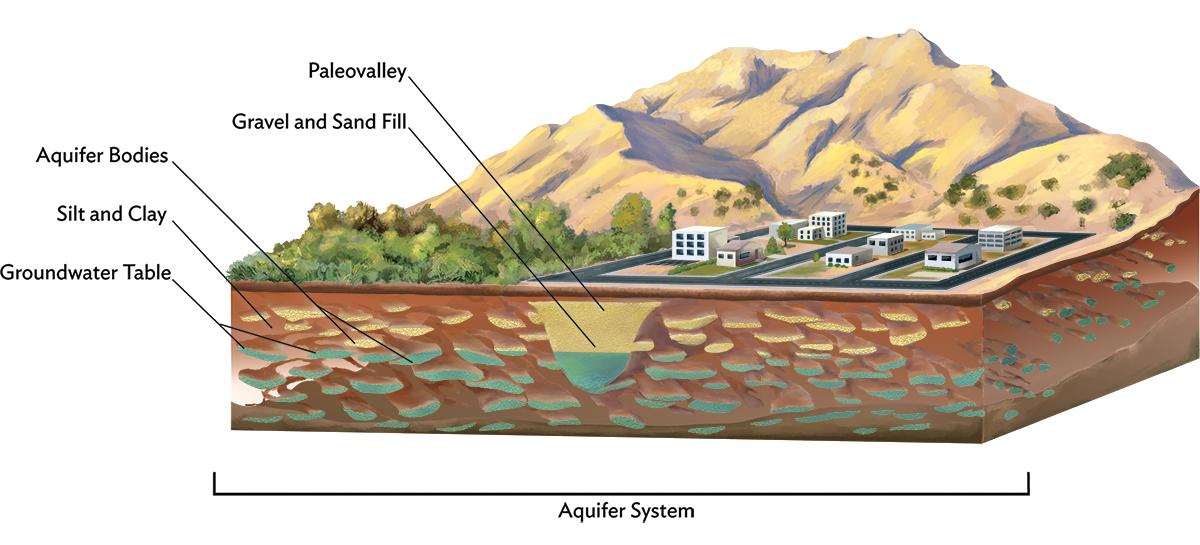
These events repeated themselves over the last million or so years, as glaciers crept down from the north, then retreated. Four of these events have left imprints of their icy ebb and flow below the valley floor. Called paleo valleys, these buried historic riverbeds are still the paths water wants to travel underground, like slow-motion rivers. Their extreme permeability means they can absorb about 60 times more water than the surrounding clay. Aquifers, which are better known, also hold water in coarse soils. But the paleo valleys born of the most recent glaciations are truly special, according to UC Davis professor emeritus of hydrogeology Graham Fogg—the most significant feature underlying the Central Valley. They have super powers for moving water underground because they are exceptionally large, have unusually coarse gravel, and are relatively shallow—perhaps just a meter or two below the surface. Fogg says that every significant stream coming out of the Sierra today should have paleo valleys buried in the plateau. But only three have been discovered so far in California.
This article is adapted from Water Always Wins: Thriving in an Age of Drought and Deluge, a book forthcoming in May by Erica Gies pubished by the University of Chicago Press. Learn more at SlowWater.world.
Fogg has a long-held dream: to find more of these paleo valleys and use them to replenish groundwater, depleted by our overpumping. When today’s heavier winter storms have filled up reservoirs, we could move the excess stormwaters that would otherwise flood homes and businesses atop these paleo valleys, using them as giant storm drains. The water would be absorbed quickly underground into the paleo valley, then seep more slowly into the surrounding clays. Using the paleo valleys for stormwater management would help to heal the hydrological cycle; it would refill groundwater, raise the water table, make surface flows stronger and healthier, and allow people to continue to pump water from wells.
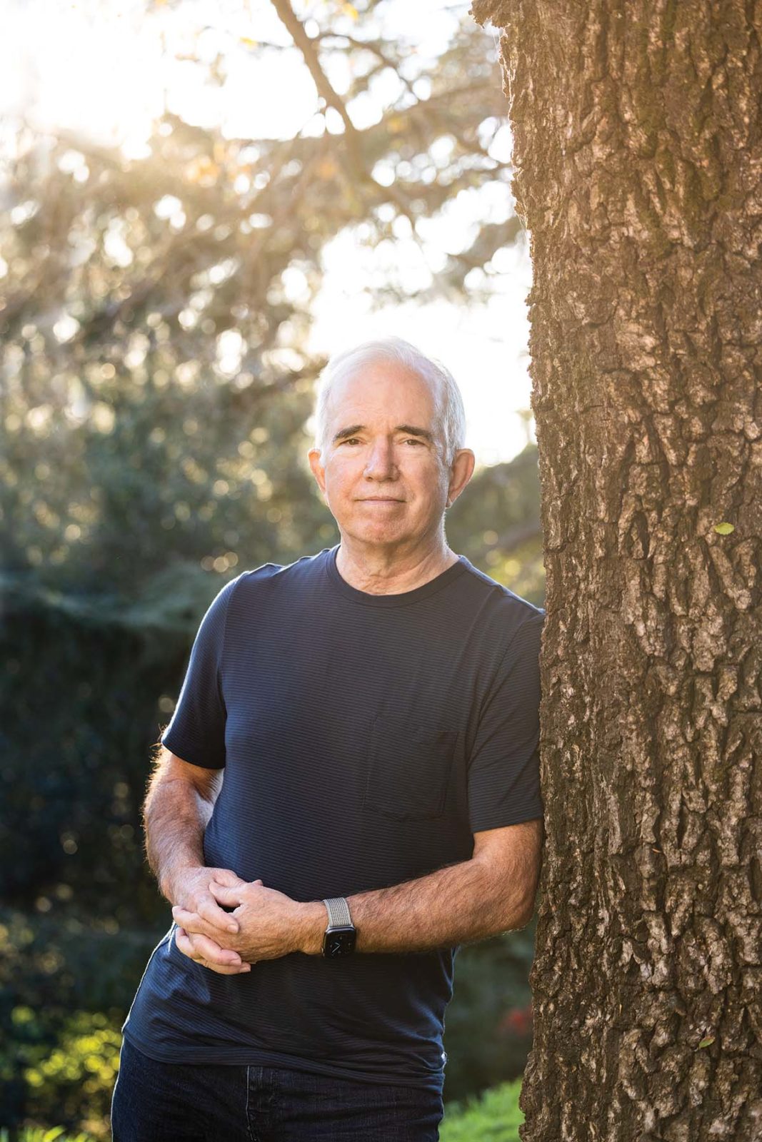
Fogg calls this strategy to balance water extremes in the age of climate change “a no-brainer.” A mild-mannered man with white hair and glasses, he clearly loves teaching. Groundwater is both an expertise and a passion, reflected in his Tesla’s vanity plate that reads “GRD H20.” Officially retired but still hard at work, advising grad students, reviewing new papers, and conducting research, Fogg can’t let go of the mystery beneath our feet. “My wife thinks I’m incapable of retiring,” he says.
What drives him still is his belief that a better understanding of water’s relationship with buried geology will mean these natural systems can both protect human habitat from flooding and sock away big water reserves to help us survive today’s longer droughts. For decades, as Fogg was putting out the call to find more paleo valleys, few people were listening. But lately, that’s beginning to change.
Water Security in the Underground
California has a long history of swinging between droughts and floods, but climate change is making both cycles more extreme. A thirstier atmosphere evaporates more water out of the soil. And warmer air holds more vapor, so when it rains, it can really pour. Examples include the 2011–17 drought, the atmospheric river storms of winter 2016–17, and the current drought that began in 2020. The state’s rapidly rising population, which has doubled since 1970 to around 40 million today, is also raising the stakes for these water extremes: more people live on land that floods and more people require water during droughts. As the previous drought wore on and meteorologists began to predict winter 2016–17’s torrents, water managers’ thinking started to align with Fogg’s. They wondered: how could they capture the big rains to come, saving water for the next dry spell?
The need to capture winter rains is all the more urgent because climate change is also erasing the Sierra Nevada snowpack, which stores and then supplies 30 percent of the water, on average, that California’s residents consume annually. Climate scientists predict that by 2100, the snowpack could shrink by four-fifths or more. With more precipitation falling as rain rather than snow, water moves down from the mountains faster, increasing winter floods and decreasing summer water supply.
Pumping groundwater has also been a huge source, accounting for up to 60 percent of human supply in drought years. But the last drought showed that practice is unsustainable, as the water table dropped thousands of feet below the surface in places. One silver lining to California’s decades of overpumping is that there’s now a lot of space underground. In the Central Valley, depleted aquifers have unused capacity that is three times that of the state’s 1,400 or more reservoirs. It’s also pretty cheap: storing water underground costs roughly one-fifth the price of building new reservoirs.
While some fear that water moved belowground will be lost, they often ignore the fact that reservoirs “lose” a lot of water to evaporation (which creates rain)—the average annual loss from 721 reservoirs across the United States was nearly equal to the nation’s public water supply in 2010 . Sometimes managers also have to release water from reservoirs ahead of big storms to make space. “Loss” is already part of the status quo. And while it’s true that water underground can travel, that “loss” supports ecosystem health, reducing the need for dedicated river flows to save fish and increasing surface water supplies.
Prior to 2014’s Sustainable Groundwater Management Act (SGMA), California did not regulate groundwater use, a policy failure that gave users the mistaken impression that groundwater was a separate, backup source of water when rivers ran low. But in fact, surface and groundwater are connected via gravity and hydraulic pressure. A full aquifer can push water up through a streambed during the dry season to keep the river flowing. And vice versa: when groundwater levels fall, water in a stream can sink underground to refill the aquifer, leaving less surface flow. Gravity pulls water toward the center of the earth. Then when it reaches certain depths, hydraulic pressure can drive the water upward. This phenomenon feeds springs, perennially flowing creeks, and most wetlands, which would not survive without upward-flowing groundwater. A healthy water table also helps plants to stay hydrated, making them less likely to burn in forest fires. But people began aggressively pumping groundwater in the mid-20th century, so today upward-flowing water is diminished and, in some places, gone, which can mean dry springs, empty creeks, and desiccated wetlands.
Our heavily engineered water management is intensifying problems in other ways. To create California’s agricultural empire, we rush water off the land, depriving it of its natural slow phases in wetlands and floodplains that allowed it to infiltrate deep into the ground. In fact, before we built levees and filled in wetlands, nearly the entire Central Valley would flood most years; some areas remained inundated for six months at a time. Without that natural recharge, pumping depletes groundwater more rapidly.
During the last drought, water managers began to panic as dropping groundwater levels accelerated other problems. Some places experienced sinking land, or seawater seeping into fresh water supplies along the coast, or wells running dry. These hazards convinced California lawmakers to pass SGMA to regulate groundwater for the first time. As that law is starting to come into effect, local water managers across the state are increasingly considering recharge. Such wide-scale efforts would reclaim land for water’s natural slow phases. It’s part of a worldwide shift in nature-based approaches to resource management that I’ve come to think of as the “slow water movement” while researching my upcoming book Water Always Wins.
To recharge groundwater, paleo valleys aren’t required, but they could provide some important options. Recent recharge projects moved back levees and reclaimed parts of floodplains in the state. Others temporarily flooded farms. But agricultural fields aren’t always ready to recharge when the winter rains come. Sometimes farmers have just applied fertilizer, so flooding the field would move pollution underground, or a crop might be harmed by the water. These challenges have led to Fogg’s excitement about the promise of paleo valleys and their potential to sidestep conflicts with agriculture.
Hunt for the Wild Paleo Valleys
Like many Californians, I had not given a lot of thought to what lies under my feet. If asked, I’d have come up with soil, rock, sand, clay, possibly some pockets of oil, gas, minerals, water. That’s not wrong, but it leaves a lot out. I learn more when I meet up with Graham Fogg northwest of Sacramento on a hot May day so he can show me subtle signs of water’s past on today’s landscape.
Fogg made a name for himself in hydrogeology with a landmark 1986 paper, in which he argued that predictability is the key to grokking underground systems. Hydrologists have tended to overlook the structure of the underground because it was thought too chaotic to measure. But the glacial episodes that laid down the paleo valleys mean they have an inherent predictability, making it possible to understand what we can’t see. “That’s how I can say that every major stream coming off the Sierra Nevadas has a shallow paleo valley produced by the last glacial episode,” Fogg explains. The paper also argued that passages between coarser sections create flow paths that water prefers.
In the Central Valley, 65 to 80 percent of the underground is silt and clay. Throughout that substrate, imagine the paleo valleys like “the veins and arteries of the groundwater system,” where water really flows, says Fogg. From those arteries, water moves much more slowly into and out of the surrounding clays and silts. Fogg likens the latter to our body tissues. “Most of your body is these soft tissues that water moves in and out of more slowly, by molecular diffusion and other processes.” In this way, water introduced to the paleo valleys would raise the water table closer to the surface across a wide area.
Paleo valleys—which scientists also call incised valley fill, or IVF—were first described by geologists starting in the 1980s. But it would be more than a decade before Fogg’s PhD student Gary Weissmann discovered the first one in California. Today Weissmann is a professor of hydrogeology at the University of New Mexico. Twenty-five years ago, he was studying an area near the Kings River, trying to understand whether a pesticide applied to fields near Fresno had traveled laterally underground to taint local wells. He was in the lab, going through soil cores that people collect when they drill wells to get water, oil, or gas.
Each glacial cycle leaves an identifiable soil layer in the subsurface. As Weissmann worked, he noted the soil strata in his notebook, color-coding the types of sediments along the edge of the paper. Flipping through it, looking for a particular well, he noticed the red marks he’d used to denote ancient soils from the glacial cycle known as Modesto in California, from 18,000 to 10,000 years ago, were all lining up at similar depths. He began plotting sediment types on a map, and the red-marked soils ran in two parallel lines near the towns of Sanger and Del Rey. But between them lay a gap—a different material.
“I thought, ‘That’s kind of weird,’” Weissmann recounts. He looked at additional well logs from inside the gap and saw no red soil marked there, indicating that something had cut it and moved it away. The valley was cut down into older sediment, called Riverbank, from the previous glacial cycle. That’s why he saw no red-labeled soil in the channel between the towns.
“I also saw indications of pretty coarse-grained material like the rubble deposited by glaciers in paleo valleys,” Weissmann says. “I got all excited.” Running into Fogg’s office, “I told him, ‘I think we’ve got a valley here!’” Recalling the moment, Weissmann gushes, “The discovery … was just incredible. I was giddy about it.”
Weissmann’s 1999 publication on the find in the Journal of Hydrology was well received in the scientific community, as were subsequent papers. Fogg thought the discovery’s usefulness for recharge was self-evident. He tells me, “As an academic you think, ‘OK … eventually more and more people will find these things and things will progress.’ Well, it didn’t. It basically sat there.”
Before SGMA passed, groundwater was a property right, and landowners could pump as much as they wanted. Politically, few people were interested in measuring how much groundwater was being pumped out or understanding how water moved underground. Tim Godwin is a hydrogeologist at the California Department of Water Resources who has worked with Fogg on state plans for recharge research. He attributes the lack of curiosity to economics. Mapping paleo valleys was extremely time-consuming, requiring scientists to sift through data for thousands of wells. Or, he says, “you could simply drill a well and get the water you needed.” But today, for many water users, that easy access no longer exists.
Against this backdrop, Weissmann and Fogg continued to spread the gospel through their teaching. In 2005, one of Weissmann’s grad students, Amy Lansdale Kephart, went through 10,000 well logs and discovered another paleo valley near the city of Modesto. She built a 3-D map with the data and modeled how water would flow through it, showing how useful it could be for water storage. The Modesto paleo valley is about a half-mile to a mile wide and 100 feet deep near the mountains, shortening to 10 feet farther out. She tracked its length for 25 miles and found it could influence groundwater flow—attracting water into it or pushing water out of it—for more than 12 miles on either side of the valley and for hundreds of feet in depth.
A student of Fogg’s, Casey Meirovitz, found a third paleo valley near Sacramento in 2017. Then, in 2019 Fogg’s student Steven Maples showed that the Sacramento paleo valley could accommodate 60 times more water than surrounding lands. “It’s a shame that we still don’t know where the rest of them are in California,” says Fogg in his mild way. “This should be a priority.”
Spreading Water
It is finally becoming more important to state water managers. SGMA’s passage in 2014 at last acknowledged hydrological reality: groundwater and surface water are linked. The law requires people who share a groundwater basin to devise a plan to manage it sustainably by 2040. Those in critically depleted basins were required to submit their plans by 2020. For other basins, the deadline is 2022.
Agriculture accounts for 80 percent of human water use in the state, so the industry is heavily affected by the law and will need to make changes. Bringing a groundwater basin into balance could mean that some farmers shift to less water-intensive crops or take marginal farmland out of operation and return it to wildlife. They could also embrace recharge so they can continue pumping when needed. Godwin, a leader in SGMA implementation at the Department of Water Resources, says that, of the groundwater management plans the department has received, “almost everybody has some aspect of recharge. It’s in at least 90 percent, 95 percent of them.”
Although the sense of water scarcity is often palpable in California, in fact there is enough unmanaged surface water statewide to resupply Central Valley aquifers, according to a 2017 study. The state’s big engineered canals and aqueducts that start up north (where most of the rain falls) and fill irrigation systems in the south are underused in winter when fewer growers need to irrigate, so they could be used to transport excess winter stormwater to depleted aquifers.
Enough water will likely also be available in the future, even with climate change. A 2021 study modeled floodwater quantities for recharge in California under different climate scenarios. The authors found that under a low-emissions trajectory, water available for recharge would increase in 56 percent of the state’s subbasins during the period of 2070–2099. A high-emissions trajectory would see an increase in 80 percent of subbasins. However, infrastructure limitations and policy hurdles must be overcome to make full use of the bounty.
Taking to the Sky to Peer Underground
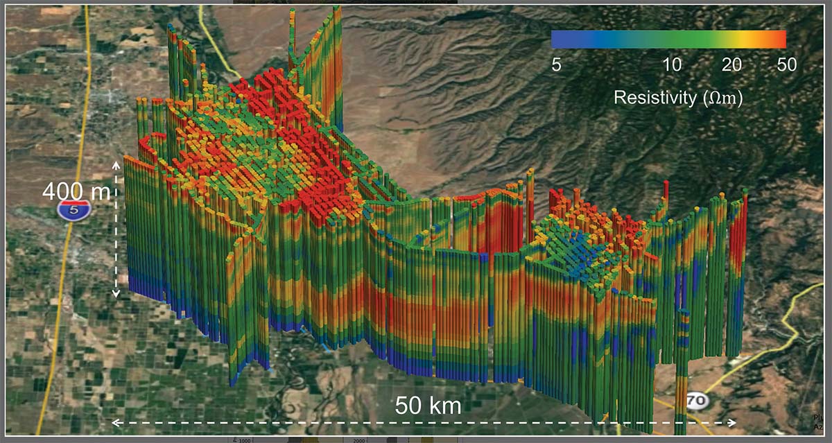
Finding more paleo valleys could help. But with just three discovered over 25 years, water managers need to pick up the pace from monthslong scouring of well logs to more broadly mapping the subsurface. Enter the helicopter. California’s Department of Water Resources (DWR) is investing $12 million from Proposition 68 to map about 100 groundwater subbasins throughout the state using a technology called airborne electromagnetic (AEM) surveys.
In December 2020, a pilot and a technician flew the first survey in a trial run led by Rosemary Knight, a geophysicist at Stanford. They were searching for paleo valleys and other underground architecture over Tulare and Fresno Counties. Hanging from the helicopter was a box about the size of a portable generator. Beneath that, a large hexagram of pipe dangled from ropes, giving the impression of a giant lasso, frozen open. The lasso is a transmitter through which electrical current flows, setting up a primary magnetic field. It generates eddy currents at various depths beneath the ground, and that, in turn, creates a secondary magnetic field measured by a receiver.
After collecting the data, Knight’s team color-coded it. The resulting 3-D image shows sediments with low electrical resistivity, such as clay, in blues, and high resistivity materials, including sand and gravel, in red. Their map covers about 300 square miles and depths up to 1,000 feet. Swirls and pockets of red among the blues reveal where water flows most easily.
Following on from that research, DWR’s partners began running surveys for its three-year comprehensive mapping project in summer 2021. Data will be made available on a rolling basis starting in early 2022, says Katherine Dlubac, AEM project manager for DWR.
Fogg thinks that AEM will be “game-changing” for finding the rest of the paleo valleys in California. Still, the helicopters are flying a “coarse grid,” says Godwin. After creating a rough map of the underground that will hopefully reveal paleo valleys (and other features), people will still need to map detailed information about them, either with higher-density airborne surveys or the old-school way, with data from drilled wells. Godwin says he hopes that local groundwater sustainability agencies will use the initial data from DWR as a starting point for their own. More detailed investigations can ultimately reveal where they can access paleo valleys to move large quantities of water underground quickly, or at least better understand the aquifer system to help them keep water levels in balance through other measures, such as regulating pumping.
Holding Space for Water
As for Graham Fogg, his decades-long dream of using paleo valleys for recharging water is finally inching closer to reality. But many land use decisions are local, and much work remains to convince decision makers. On our field trip, Fogg shows me the Folsom South Canal, a straight concrete channel filled with water diverted from the American River. It goes largely unused, he tells me, as agriculture has moved on. Just beyond the canal lies an undulating field that rests atop the Sacramento paleo valley. This proximity of underused water to paleo valley makes it a prime spot for a conservation recharge zone—but a large private development is planned for the public land atop the paleo channel.
“I like Graham’s vision,” says Tim Washburn, a senior planner at the Sacramento Area Flood Control Agency, “but it’s very unfortunate that the land use got out ahead of the land use planning. And now we have development that has progressed far enough along that it becomes very hard to stop.” Another barrier, he tells me, is that people in Sacramento are much more concerned with flooding than with water scarcity. Water is typically so plentiful that the local utility didn’t even start measuring people’s consumption until a few years ago. “We don’t have a compelling enough need in the minds of our local leaders” to consider recharge as a better long-term use of this land than the planned development, he says. What local decision makers seem to be overlooking is that the paleo valley could also give them another option for flood control; that’s a significant part of Washburn’s interest.
Godwin says he hopes that SGMA will push water users to look at city and county general plans and begin a dialogue with local land-use authorities. The governor’s water resilience portfolio has also identified this issue. “The AEM data will be really, really helpful at informing some of those conversations,” says Godwin.
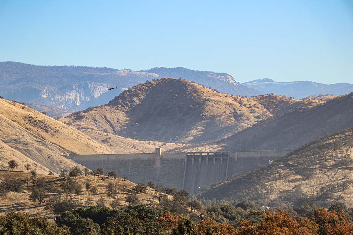
In Sacramento, Folsom South Canal is owned by the federal government, which also owns a narrow strip of land alongside. Fogg may have visionary ideas, but he’s also a pragmatist. Injection wells drilled on the federal land could be a compact way to move canal water into the paleo valley. Fogg has talked to Washburn about it, who is working with the Bureau of Reclamation to try to seize this opportunity. “There’s plenty of space to store water,” Fogg says. “You could build the equivalent of another Folsom Lake,” citing the reservoir just up the road that holds nearly a million acre-feet. A demonstration project showing the paleo valley’s speed and capacity could be revelatory.
Fogg remains hopeful, citing the enthusiasm of people such as Godwin and others at DWR to identify paleo valleys for recharge projects. In a 2011 speech accepting an award from the Geological Society of America, he revealed the quiet confidence that has kept him faithful to his vision during the decades in which few seemed to understand or care. “Decide in your head and gut what you think is the right path, and never give up—and of course, never stop listening.”