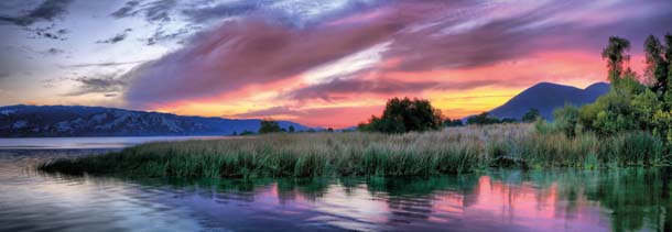
We’ve thought about doing a piece on Clear Lake for a long time: It’s a wildlife magnet just over two hours from our office in Berkeley, and yet relatively few Bay Area nature lovers ever visit.
You might imagine that Clear Lake was named for the clarity of its water. Not so. It turns out that early European settlers named this lake for the clarity of the region’s air, which today remains some of the best around. Before the Europeans named the lake, the local Pomo people called it Lypoyomi, or Big Water. And so it is: Clear Lake covers 44,000 acres and its shoreline stretches 110 miles. That makes it the largest freshwater lake entirely inside California.
And that’s not the lake’s only superlative. It’s also the oldest lake in the state and possibly the oldest in North America. The region sits at the edge of a large volcanic field, and constant tectonic movement has kept Clear Lake from filling in with sediment for two million years.
Terry Knight is an outdoor adventure enthusiast who’s lived on the lake for 25 years and writes an outdoors column and feature stories on the area’s environment for the Lake County Record-Bee. He sent us a few vignettes that capture several of his favorite places around the lake, though he makes it clear there are many more to be explored.
–Dan Rademacher, Editorial Director
The Birds
“Every day on the lake is an adventure. One day I will see a flight of white pelicans gliding over the water and the next day there will be grebes doing their mating dance along with an osprey grabbing a fish. In my opinion it is one of the most dynamic lakes in the world.” — Greg Giusti, University of California scientist
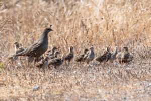
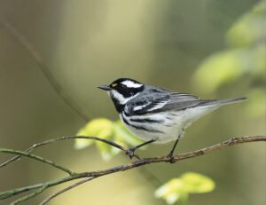
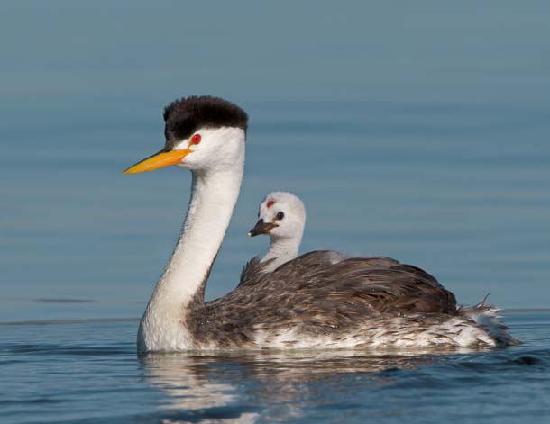
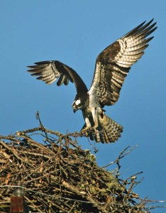
Clear Lake is home to more than 300 species of birds, from eagles and osprey overhead to grebes and mergansers on the water and egrets and herons along the shore. At one time it was estimated that the lake’s population of western grebes exceeded 50,000. You can spot them from just about anywhere on the lake, but the best place to see these elegant-looking birds is on the water from Long Tule Point to Adobe Creek, where several thousand of them nest in spring and early summer. A great way to observe them is from a kayak or other small, quiet boat launched at the Lakeside County Park, only a short paddle away from the nesting area.
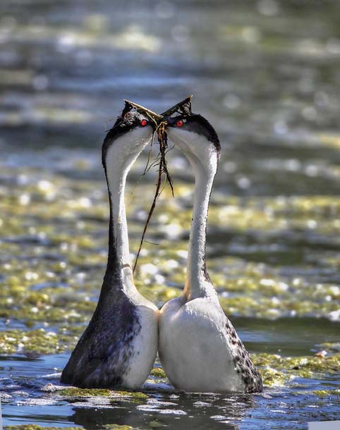
Western grebes are known for their spectacular springtime courtship dance. The male approaches the female and does a series of dips with his head. She responds with like dips and then they run across the surface of the water with their necks arched in perfect unison, finally diving underwater at exactly the same moment. During this maneuver, called “rushing,” the birds race across the water so fast they appear to be hydroplaning.
While you’re watching the grebes, keep an eye out for osprey and bald eagles. The eagles prey on grebes and other waterbirds, so watch for them perched in the trees in the grebe nesting areas, looking for an easy meal. Ospreys don’t prey on birds, but they’ve learned that where there are grebes, there are abundant fish. At the county park, look for the huge osprey nest, where you can often see a pair tending to their young. A family of river otters also lives nearby, and white pelicans are a common sight on the lake at the mouth of Adobe Creek.
The Water Trails
“Things have changed a lot up at Clear Lake. I’ve noticed things about kayaking, wildlife areas. None of that existed when I was there before.”
Julie Donnelly-Nolan, USGS geologist who mapped the area in the 1970s and 80s
Clear Lake’s network of seven water trails is the brainchild of Holly Harris and Charles Lamb, a husband-and-wife team who moved to Lake County in 2000 and founded Konocti Regional Trails in 2007. Harris says Clear Lake is ideal for water trails because there are 11 free public boat ramps (find maps at konoctitrails.com/water-trail-loops).
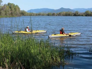
“We created the water trails primarily for kayakers because kayaks have a low impact on the environment and allow people to approach many of the waterbirds without disturbing them.” Harris says. “The trails have become so popular that we plan to expand them to cover the entire lake.”
Note that wildlife biologists say you should stay at least 200 feet from nesting birds so they won’t be disturbed.
One popular boating route is the Rodman Slough Water Trail (Clear Lake Water Loop 7). The trail, located at the north end of the lake, is about eight miles round trip from the launching area at the bridge that crosses the mouth of the slough. The entire water trail is protected from the lake’s often-strong winds and showcases a wide variety of birds and wildlife, including a large blue heron rookery. The Lake County Land Trust operates a nature center here that offers weekly nature walks.
Clear Lake Water Loop 5 (known as the Soda Bay Trail) starts at Clear Lake State Park on the southwest side of the lake, which is also a great place for seeing wildlife from shore. Park superintendent Bill Salata says he’s spotted bobcats, deer, river otters, bald eagles, and even an occasional mountain lion on his daily patrols.
This water trail covers the Soda Bay area, where volcanic gases still bubble to the surface, evidence of the region’s restless geology. Though Clear Lake is quite shallow, averaging 15 feet in the north end and 25 feet in the south end, Soda Bay has several vent holes that are reportedly more than 100 feet deep. The water temperature near these vents is often more than 20 degrees warmer than the surrounding bay. Geologists theorize that the warm water is coming from beneath nearby Mount Konocti, a dormant volcano.
The Mountain
“We envision a trail from Clear Lake State Park to the top of Mount Konocti.”
Charles Lamb, Konocti Regional Trails
Overlooking Clear Lake is majestic 4,300-foot Mount Konocti, whose name is derived from the Pomo words kno, for mountain, and htai, for woman. The summit, privately owned since the 1800s, was mostly inaccessible to the public until 2011, when the county purchased 1,500 acres and turned it into Mount Konocti County Park.
Though it’s quiet now, eruptions started here about 350,000 years ago and happened as recently as 10,000 years ago. Konocti’s five peaks are the cones that resulted from a series of nonexplosive eruptions and lava flows.
The four-mile hike to the summit starts at a parking lot halfway up the mountain. The trail is a dirt road used by technicians to access the cell phone towers that dot the peak. But there’s some wildness here, including a grove of canyon oaks, some believed to be more than 500 years old. And some more recent history as well: In the middle of the grove of oaks, turn down a dirt road to see the cabin built in 1903 by a homesteading widow who used a mirror to signal a greeting to her daughter in Lakeport, 10 miles away. Retired park ranger Tom Nixon, now a volunteer hike docent, likes to demonstrate the process, flashing a mirror and receiving a reply from another volunteer in town.
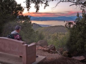
Traveling back on the main road you hike another two miles to Wright Peak. At 4,286 feet, Wright is the tallest of Mount Konocti’s five peaks. The summit offers an excellent view of Clear Lake, and on clear days you can see Snow Mountain to the north, Mount St. Helena to the south, and even all the way northeast to Mount Lassen.
Getting There
From the Bay Area take Highway 101 north to Ukiah and go east on Highway 20 to Clear Lake, or turn on 175 at Hopland for a shorter, curvier ride. From Sacramento, take Interstate 5 north to Williams and Highway 20 west to Clear Lake. Mount Konocti is accessed off Konocti Road in Kelseyville. Download maps of the water trails and Mount Konocti at konoctitrails.com. For Clear Lake State Park, call (707)279-4293 or visit clearlakestatepark.org. For information on kayak rentals and accommodations, call the Lake County Visitor Information Center at (800)525-3743.
Terry Knight writes about fishing and the outdoors for the Lake County Record Bee, and he also serves on the Lake County Fish and Wildlife Advisory Committee and the Clear Lake Invasive Species Council.