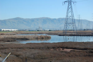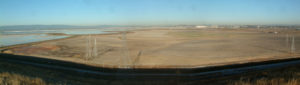
On January 22, 2012, at 10:15 in the morning, Sheryl Drinkwater stood on a soggy piece of ground near Radio Beach at the northeast foot of the Bay Bridge. Behind her, cars whizzed through the toll plaza. In front of her, the normally sandy beach was submerged. The access road to the beach, which runs parallel to the freeway, was also under a couple of inches of litter-laced water.
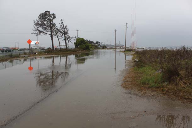
The flooding was not the result of a biblical deluge or a freak winter storm pushed by crisp winter winds from the North Pacific. Instead, the Bay nearly lapping the toll plaza was caused by a particular alignment of the sun, the moon, and Earth, causing an extreme tidal event. Big tides happen when the moon’s elliptical orbit brings it closest to the earth while it is also in a full or new phase. Such gravitationally influenced extreme tides usually happen twice a year. They are called perigean spring tides, or, more colloquially, king tides.
Drinkwater, a Berkeley-based architect who is also a board member of the grassroots nonprofit Friends of Five Creeks, is interested in water and infrastructure. Reflecting on her Radio Beach experience, she says, “To see a place that I pass regularly affected like that left a big impression. I used to just think about getting through the toll plaza as quickly as possible, but now I think about flooding in a place that is so key to our Bay Area civilization.”
When Drinkwater got home she uploaded her photos of the inundated Radio Beach to a Flickr site run by the California King Tides Initiative. The project is part of a worldwide network focused on climate change awareness. The roots of the global initiative started on the east coast of Australia in 2009 when a government environmental agency asked residents to take photos of the king tide events and share them on social media as part of a public education campaign on sea level rise. As it turns out, photographic documentation from regular citizens of the vulnerability of coastal areas can be much more compelling as a “wake-up call” than dozens of cogent white papers or well-researched scientific reports on climate change. If a picture is worth a thousand words, then imagine the power of thousands of pictures of actual rising sea levels — even if, for now, the high water only lasts for a few hours or days at a time.
The success of the Australia project spurred discussions in the Bay Area conservation community about starting a similar initiative here. Heidi Nutters, currently Coastal Training Program Coordinator at the San Francisco Bay National Estuarine Research Reserve, but at the time a fellow at the Bay Conservation and Development Commission (BCDC), volunteered to help organize the first king tides project in California.
“I worked with partners and put this together in a month,” says Nutters about the effort in the winter of 2010. “We wanted to see what would happen. The response was overwhelming.”
Nutters attributes the early success of the project to the wide audience and its usefulness to different kinds of environmental organizations working on coastal conservation. “We all have diverse interests and different sets of goals,” says Nutters about the advocacy, policy, planning, regulatory, and educational organizations that are helping on the initiative. “But sea level rise is a real rallying point for all of us, and a good way to engage the public on the impacts of climate change.” Climate education is often criticized for being political, alarmist, or speculative. The regularly occurring king tides are apolitical and very real.
Since its beginnings in 2010, the project has grown steadily with about a dozen organizers who either carve out time from their regular jobs or volunteer their personal time. Besides being an organizational hub locally, the California King Tides Initiative has become a model for other educators and advocates across North America.
The core of the project is its growing public archive of images. “We’ve built a pretty robust catalog of images and the usefulness keeps expanding,” Nutters says. Some of the first uses of the king tides images, which are all licensed under creative commons laws — meaning anyone can use them with proper attribution — were by climate change scientists who found that they make compelling companions to dense sea level rise data.
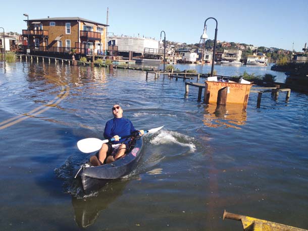
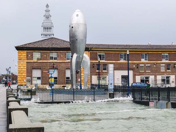
During the 2011 winter king tides Nutters was invited on a boat ride along the San Francisco waterfront and, despite the rough conditions, was able to snap a photo just as the surging Bay waters crested the iconic Embarcadero. The photo has since been used widely on the cover of sea level rise reports and in the media.

King tides for the winter of 2013–14 are expected to occur at the end of December and January (Dec. 30–Jan. 2 and Jan. 29–31). After several years of more or less ad hoc efforts, local project organizers are preparing for this year’s events by developing more standardized citizen science protocols. For the first time, volunteer photographers will have a list of specific places to document. Organizers are selecting the sites based on several criteria, including where actual climate modeling research is already happening. Choosing particular spots to focus on during high tides will provide a glimpse of the future “normal” for those areas, as well as providing visual baseline documentation of how coastal areas are changing over the long term. Paired with actual scientific research, the photographs should show how well climate models hold up. “We are starting to use the images to validate climate models,” says King Tides Initiative organizer Marina Psaros. “That means that the people taking the pictures are working in partnership with researchers, so it’s a good way to think about citizen science.”
Climate change educator and former BCDC director Will Travis compares the work of the current king tides photographers to that of a previous generation of influential photographers. “It’s just like the images in the 1960s that showed what the Bay would look like by 2020 with more landfill and reclamation. People saw a future they didn’t want,” Travis says. “The king tides show in a very graphic manner what sea level rise will look like. It’s about the closest thing to a time machine I’ve ever seen.”
CA King Tides Initiative’s image catalog is at flickr.com/groups/cakingtides/. To find out more about this year’s project, go to californiakingtides.org.