.jpg)
In the early 1950s, for less than $15,000, you could buy a house overlooking the Pacific Ocean in Daly City. The comfortable homes in builder Henry Doelger’s new Westlake Palisades subdivision came with a Joshua tree in the front yard, a tidy backyard, and, if you were on Westline Drive near the ocean, a spectacular view of Mussel Rock (a sea stack a few hundred feet off shore) and the waves crashing on the beach below. You probably didn’t think about earthquake faults, landslides, or coastal erosion. In those days, there were no real estate disclosure laws to warn you of the risks. But Westlake Palisades was built within a stone’s throw of the San Andreas Fault and along one of the Bay Area’s most actively eroding coastlines. A combination of geological processes and construction by humans ensured that here high places would, sooner or later, become low. And given the soft underlying rocks, that meant sooner for many residents. In spite of great expense and dogged efforts to build permanent structures in an impermanent landscape, here the sea always wins in the end.
Winter is the season of landslides. In the Bay Area’s Mediterranean climate, winter means rain, and once the ground is saturated, the soil tends to flow downhill. Along the coast, winter storm waves accelerate the downhill erosion process as they pound the base of the sea cliffs. Where the cliffs are composed of hard rock, the attack of the sea wears the land back slowly. But where the cliffs are weak sedimentary rock, as they are just south of San Francisco, heavy rain and high seas combine to erode the cliffs back at a rapid rate. Add movement on the nearby San Andreas Fault and construction by humans, and the stage is set for geology in action. Along this coast geological processes can work dramatically in months or years instead of the centuries and millennia of most geologic events. Regardless of the cleverest engineering, the cliffs flow down—taking houses, roads, and backyards with them.
The steep sandy cliffs from Ocean Beach in San Francisco south to Pacifica are composed of sedimentary rocks so young and weak, geologically speaking, that they hardly qualify as rock. At most a couple of million years old, they consist of particles that are only weakly compressed and cemented together. A brush of the hand sends sand grains down to the beach. A heavy rain brings them cascading down from the cliffs in a torrent. An earthquake starts a landslide. This is a landscape in motion. Flowing cliffs have been the story in these rocks for as long as people have lived along this coast. And long before that.
Rates of erosion in these rocks can average up to two to three feet a year. That doesn’t mean two feet every year; it is an average rate of erosion over the past half century or so in which measurements have been made. Decades may pass with little erosion, relaxing concern about living at the edge of the sea. But in El Nino winters, coastal erosion can be rapid and severe. El Nino events bring a warming of ocean temperatures that can result in heavy rain in California (and drought elsewhere). In a major El Nino storm, especially if it occurs during a time of high tides, waves crash against the sandy San Mateo cliffs. Ten or 20 feet of backyard may be lost in a few days or weeks, and houses set back from the cliff 40 years ago may dangle over the edge. Major El Nino storms since the 1980s, after decades of only small events, have wreaked havoc on the Bay Area coastline. The El Nino of 1982-3 was the largest event since 1950, when good records were first kept, and portions of the cliffs along the coast flowed to the sea during several heavy storms that winter. The El Nino of 1997-8, which also caused major damage, was the second largest.
This is nothing new. In the late 1800s little thought was given to the underlying geology when the Ocean Shore Railway Company started construction of its line down the coast. The railroad was built to connect San Francisco with the coastal resorts at El Granada, Miramar, and Half Moon Bay, and with the city of Santa Cruz. The line had been finished as far as Mussel Rock near Daly City when the 1906 earthquake caused the cliffs to fail, sending almost a mile of track and equipment into the sea. The railroad repaired the tracks and struggled for years to keep the trains rolling through soft, sandy soil that wouldn’t stay put. In 1920 the railroad stopped trying, victim of the high cost of maintaining a roadbed along the eroding cliffs. Undeterred by the railroad’s experience, in the 1930s the Department of Highways (now Caltrans) acquired the roadbed and constructed Cabrillo Highway (Highway 1). The road builders had trouble keeping soft sediment from flowing onto the pavement and the asphalt from sliding to the sea. They abandoned the attempt after the March 1957 Daly City magnitude 5.3 earthquake, which sent major sections of the road down the hill. The epicenters of both the 1906 and the 1957 earthquakes were on the San Andreas, not far from Mussel Rock near the Daly City border with Pacifica, where the San Andreas Fault heads to sea after its 600-mile journey through California from Mexico. At Mussel Rock the San Andreas Fault passes through a huge ongoing landslide, 9 million cubic yards of rock slowly moving seaward. The Mussel Rock landslide—the term in this case refers to a geographic feature rather than an event—extends out to sea for at least four miles and is thought to be the second-largest active landslide along the entire California coast. Only the massive Palos Verdes slide in Southern California is larger.
The Merced and Colma Formations
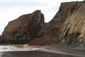
The soft, easily eroded rocks along this stretch of coast are called the Merced and Colma Formations. (A formation is a rock unit formed under similar conditions at about the same geologic time.) Spectacular exposures of these rocks make up the cliffs between Fort Funston (in San Francisco) and Mussel Rock. The Merced Formation makes up most of the steep cliff face; the Colma Formation is a thin sandy layer at the top.
The Merced and Colma Formations consist mainly of sandstone, a sedimentary rock formed from bits and pieces of older rocks. These formations are easily eroded because no substance has glued the sand grains together. In other sandstones, minerals such as quartz or calcite have seeped into spaces between the grains and cemented them into a harder rock. But in the Merced, these spaces often are filled with water, making it an important aquifer that provides up to half the drinking water for northern San Mateo County.
The Merced was deposited from about 2 or 3 million years ago to about half a million years ago and the Colma during the most recent interglacial period, about 125,000 to 55,000 years ago. Movement along the San Andreas Fault since the Colma was deposited has uplifted both formations to their present position above the sea.
The Merced rocks are made up of sediments that were deposited in coastal environments similar to those along the San Mateo coast today. The sediments include sand deposited in moderately deep water on the continental shelf, in shallower water near shore, on the beach, and in dunes. Terrestrial pond and marsh deposits are also present. On a visit to Pescadero State Beach, you can explore similar environments, from the sandy beach to the marsh preserve across Highway 1. In 1 or 2 million years, today’s sands and marsh deposits will have formed rock much like that in the Merced sea cliffs.
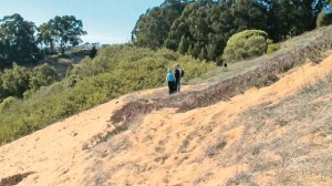
The Merced Formation is a treasure trove of interesting geology. As you walk south along the cliffs from San Francisco’s Fort Funston, you stroll past layer after layer of Merced rocks, most tilted from their original horizontal position. The characteristics of the sandstone and fossils in each layer are clues to environmental conditions when they were deposited. The whole sequence of layers, over one mile thick, indicates gradually shallower conditions along the coast over time. The older rocks to the south are mainly marine; to the north the Merced contains more terrestrial deposits. In addition to the overall shallowing sequence, the layers show recurring changes from marine to terrestrial conditions within a much shorter time scale. These changes are repeated many times along the cliffs and are probably the result of fluctuations in sea level over the past million or two years as ice ages came and went.
Take a magnifying glass or hand lens to the beach so that you can see the great variety of sand grains and organic particles, such as shells and plant debris, that make up the rock. Look closely at the cliffs and you can find fossil whale bones, clams, mussels, scallops, and sand dollars in layers that were originally marine or beach sands. Remains of horses, camels, and mammoths have washed out of terrestrial deposits. You can also spot several distinct orange fossil soil layers and prominent white ash layers from distant volcanic eruptions.
The Merced layers also record an important event in Bay Area geology. The mineral grains in the older sandstone in the lower two thirds of the cliff come from local sources. In the upper third, mineral grains from the Sierra Nevada are mixed with local grains. This change, which occurred about 620,000 years ago, marks the opening of drainage from the Central Valley through the Bay Area, when the Sacramento-San Joaquin River system, which carries sediment from the Sierra, began to flow through San Francisco Bay. Previously, the Central Valley had drained to the ocean at its southern end near the present Kettleman Hills in Kings County.
The Colma Formation, which overlies the Merced Formation, is composed of similar but younger sedimentary rocks. You can tell them apart because the Colma layers lie nearly flat and the Merced layers are tilted. On the Peninsula the Colma Formation, like the Merced, consists of sand deposited in coastal marine and estuarine environments. Elsewhere, the Colma includes terrestrial deposits. Colma sediments were deposited in a narrow seaway that extended diagonally across the Peninsula where the city of Colma is today. Both the Colma and Merced Formations have been uplifted very recently to their present elevation several hundred feet above sea level, a dramatic reminder that the Bay Area landscape is even now being shaped by tectonic activity along the San Andreas Fault.
Movement along the San Andreas breaks up the weak Merced and Colma rocks, making them more susceptible to erosion, but the cliffs are also undercut by wave action. During major winter storms, typically in El Nino years, waves may rise high enough to crash across the beach and attack the steep cliffs. This accelerates the normal coastal erosion. Construction activity has further destabilized the cliffs. Soft rocks, waves, rain, the occasional earthquake, and construction all work together to bring the cliffs down.
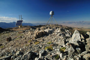
Mussel Rock
Today we would not build along these cliffs—and if we were ignorant enough to try, we wouldn’t likely get the necessary permits. In the 1950s, however, when Henry Doelger was building Westlake Palisades, we knew little about coastal erosion, the ongoing Mussel Rock landslide, or the San Andreas Fault. Despite the futile efforts of the Ocean Shore Railroad to maintain a roadbed across the flowing cliffs and the repeated failure of Highway 1, the coastal view remained irresistible. Doelger learned a quick lesson about geologic processes when 11 of the homes he was building on the north side of Westline Drive, along the upper edges of the landslide, began to move downhill soon after construction. Doelger bought them back and moved them to inland lots. The graded house pads continued downhill year after year and can still be discerned 50 feet or more below.
The El Nino storms of 1982-3 reactivated the sliding on the north side of Westline Drive. The street developed major cracks that required regular repair, and homes on the south side of the street were damaged. Sliding along the head of the landslide on nearby Skyline Drive was also severe and damaged two houses, which were relocated in 1986. Others were moved later, and the lots where they stood are now open space. The problems continued, and a 1998 geotechnical study prepared for Daly City on the Mussel Rock landslide estimated the rate of movement and how far it was likely to progress in 50, 100, and 150 years. Possible remedies, such as draining water from the area through deep tunnels to the ocean, were deemed prohibitively expensive. Utilities were damaged and cut off. After much deliberation, the city council decided that all the homes within the 50-year horizon would be removed, and in early 2000, 21 homes were demolished. Federal and local funds were used to buy the homes. Daly City was among the first cities in California ever to receive federal funds to mitigate landslide hazards. Previously, such funds had been used only to address flood hazards. With the homes gone, Westline Drive was closed and the area was designated as open space. Looking at the grassy slope today you wouldn’t know the houses had ever been there. But the sliding continues and a new fracture promises more to come. The residents of Westline Drive have paid dearly for their dazzling ocean views.
Just a few miles north of the Westlake neighborhood, you can get another good look at the ravages of coastal erosion. Like the doomed houses of Westline Drive, Thornton Beach State Park now is gone too. Fifty years ago you could head west past vegetable farms on Alemany (now John Daly) Boulevard for a picnic by the ocean at a little park sheltered from the wind behind the cliffs. The access road branched off from former Highway 1, pieces of which still remained along the bluffs. Stairs from the parking lot took you to the beach to enjoy the waves and the intricacies of the layered Merced Formation rocks in the sea cliffs. But the El Nino storms of 1982-3 destroyed the park. Rain soaked the weak rocks, and inadequate storm drains funneled runoff onto the cliffs. What began as a trickle of sand onto the parking lot that first winter soon became a flooding slurry that carried pieces of pavement with it, tearing huge gaps in the access road. After a second winter of storms, the park was so damaged that it was abandoned by the state. Today, the parking lot is under three feet of sand; the entrance kiosk, picnic tables, restrooms, and stairs to the beach have all vanished. From a new overlook at the west end of John Daly Boulevard, you can see the dramatic effects of coastal erosion in these soft rocks. A handicap-accessible trail and interpretive signs tell the story.
The homes on the bluff above the old highway bed just south of the park have also fallen victim to the eroding cliffs. Five houses were demolished or moved away and about 80 feet of the cul-de-sac at the end of Lynvale Court now rests about 100 feet downhill, just like the house pads at Mussel Rock. The Lynvale Court landslide is still actively cutting the cliff back and threatens the homes remaining in the area.
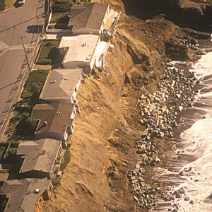
A similar story unfolded to the south of Mussel Rock, in Pacifica, where houses that perched 100 feet above the beach on Esplanade Drive also succumbed to the failing cliffs. A seawall was built in 1984 at a cost of $1 million after an El Nino storm of the previous winter had eaten away backyards. The seawall washed away in the 1997-8 El Nino storms, and the cliffs lost their protection from wave attack. Following a February 1998 storm, the cliffs eroded back more than 30 feet in two weeks. Ten houses were severely damaged and red-tagged for demolition. Seven were demolished; one fell into the sea as the bulldozers approached. Today the bluff is fenced off, and it is only a matter of time before little is left of the former lots with a spectacular view.
Back in Daly City, the cliffs retreated again in a major landslide in December 2003 near Northridge Park at Avalon Canyon, between Mussel Rock and Thornton Beach. About 500,000 cubic yards of earth flowed down the hill and out to sea. For a short time, the landslide created a prominent peninsula extending out into the ocean, but the waves carried all the material away in a few weeks. Two months after this landslide, the bluffs above Thornton Beach failed again in a large storm and a large chunk of the cliff washed to sea. More will surely come down.
Coastal erosion is a natural process in the weak rocks along the San Mateo coast, where the land and sea meet in a ceaseless conflict. The intricate interactions of water, wind, rock, and sand – sometimes slow, sometimes startlingly quick—become a geologic hazard only when human activity gets in the way. From the Ocean Shore Railroad Company in the late 1800s to the Doelger development in the 1950s to more recent attempts to build on the cliffs, we have fought a losing battle against the forces of nature. The inexorable attack of the sea will continue. The coastal rocks south of San Francisco will flow down to the sea. More houses, and whatever else we place here at the edge of the sea, will eventually flow with them.