The sun finally broke through the morning clouds at Crane Cove beach. My shoulders were sore and my thighs fatigued. I dipped the blade of the paddle and swept it back over the water to turn the nose of my board to face out toward the Bay Bridge span and Port of Oakland. I laid the paddle across my lap, noticing the gentle sway of the board as the wind picked up. Feeling less intimidated, I took a moment to grasp the view of the San Francisco Bay expanse in front of me. But I’m getting ahead of myself…
How I got to this moment of hard-earned wonder was through the San Francisco Bay Area Water Trail — a growing network of trailheads to launch and land nonmotorized small boats. It is the public resource that will get you out on the Bay, because let’s face it: you’ve driven over it, maybe ferried across it, or shared a meal next to it. But have you dipped your toe in all the San Francisco Bay has to offer? Roughly 53 trailhead sites sprinkle the shoreline of the nine counties surrounding the Bay to encourage people to explore and enjoy over 500 miles of navigable scenic and environmental splendor on kayaks, kiteboards, dragon boats, and stand-up paddleboards.
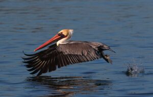
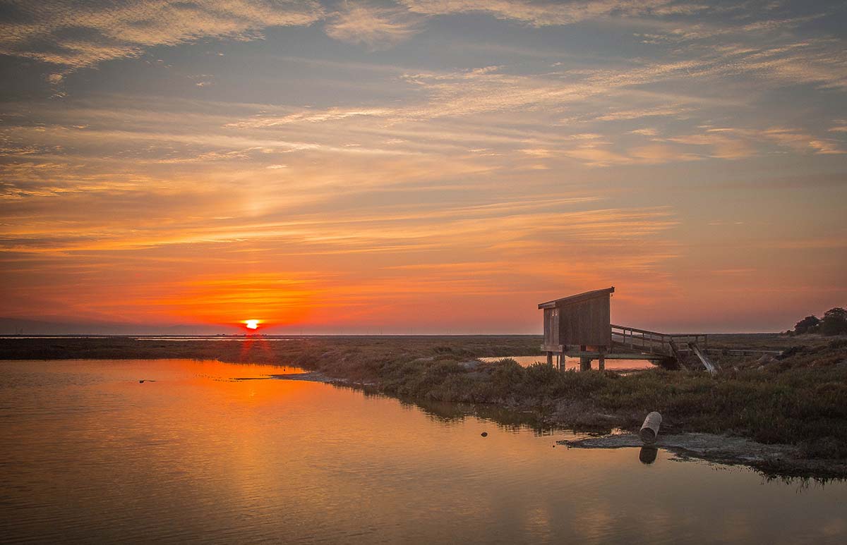
The trailheads span the gamut of habitats along the shore in the Bay and beyond. Launch into the Napa River at the semi-rural Cuttings Wharf trailhead. Explore marsh habitat and sloughs winding upriver, surrounded by hills, to the riverfront development along downtown Napa’s Main Street Boat Dock. From the sandy Encinal Beach trailhead in Alameda, glimpse harbor seals and California brown pelicans with the San Francisco skyline rising up next to you and the colossal USS Hornet Sea, Air & Space Museum aircraft carrier in your sights. Paddle into Contra Costa’s Point Pinole Regional Shoreline with camping gear to stay overnight at the campground and bring binoculars to watch the shorebirds.
Remember, they are an exotic species in the Western United States, and are rapidly increasing their geographic range and range of habitats. Are they outcompeting or excluding native species in the process? How would we know? We have done almost nothing to monitor changes in the assemblage of mushroom species in areas before and and after the incursion of death caps.
Further Reading
Pringle et al, “The ectomycorrhizal fungus Amanita phalloides was introduced and is expanding its range on the west coast of North America,” Molecular Biology 2009
Lockhart et al, “Simultaneous emergence of multidrug-resistant Candida auris on 3 continents confirmed by whole-genome sequencing and epidemiological analyses,” Clinical Infectious Diseases 2017
Battalani et al, “Aflatoxin B1 contamination in maize in Europe increases due to climate change,” Scientific Reports 2016
How a water trail is born
The vision for the Water Trail Program began in the early 2000s with Bay Access Inc., a nonprofit working with the National Park Service to ensure future access for nonmotorized small boat users. “A lot of these folks had been paddling on the water for many years. There was steady deterioration in the quality of many access points, a lack of investment, and new development was coming about,” says Ben Botkin, water trail planner with ABAG/MTC. The goal was to protect and strengthen what was already there and help people experience the Bay as the Bay Area’s largest open space.
This vision became law in 2005 with the California Legislature’s passage of the San Francisco Bay Area Water Trail Act. With the California State Coastal Conservancy leading the effort, the program grew through a collaboration with the Association of Bay Area Governments (ABAG), the San Francisco Bay Conservation and Development Commission (BCDC), and California State Parks; an advisory committee representing a broad range of interests and expertise; and partners at each site. The Water Trail Program is funded by grants from and through the Coastal Conservancy, although neither the Coastal Conservancy nor ABAG/MTC manage or maintain any of the trailhead sites. Sites are maintained by regional shoreline entities.
Most water trails tend to be along rivers, a linear trail from point to point, whereas the Bay Water Trail is an interconnected web with locations around the Bay. Currently, the trailhead sites range from launch and exit sites to destination points for a day outing. Mission Creek Boat Launch in San Francisco is one example. The site serves as a waypoint for people paddling from Pier 40 or Crane Cove Park. People can launch a stand-up paddleboard or kayak, visit Mission Creek, have a picnic at the tables there, and then paddle to McCovey Cove.
The California State Coastal Conservancy oversees the Bay Water Trail program in collaboration with other state and regional agencies. They work closely with local jurisdictions and shoreline owners and managers, whether it be the California Department of Parks and Recreation or the Mill Valley City Council, to provide access to the water. The voluntary program means to supplement the work that shoreline entities are already doing.
“We have a large outreach and education component associated with the Water Trail. The general public has a one-stop-shop to come for information on where they can get to the water, what type of facilities are there to meet their needs, stewardship information, so they know how to minimize their impact to wildlife,” says Ben Botkin, a Bay Water Trail planner with Association of Bay Area Governments/Metropolitan Transportation Commission (ABAG/MTC).
The San Francisco Bay Water Trail’s interactive website provides a map of the trailheads and offers detailed information about each, organized by county. A trip planner provides weather and paddling conditions, such as tides and currents, and water safety tips. “A core component is helping people to understand that the Bay is big and dynamic,” Botkin continues. “What can be a safe and fun paddle for a novice paddler on one day can be different within a few hours as winds pick up, or tides change.”
Other resources on the website provide links to independent groups and clubs offering local paddling opportunities. The groups build community and teach skills to people who are not familiar with getting out on the water or who feel apprehensive about going on their own.
“I am a kayaker and stand-up paddleboarder, but have the opportunity to go out with a number of outriggers, whaleboats, and some dragon boat clubs. It is a lot of fun, welcoming and friendly group[s] that are all excited to be out there,” Botkin says.
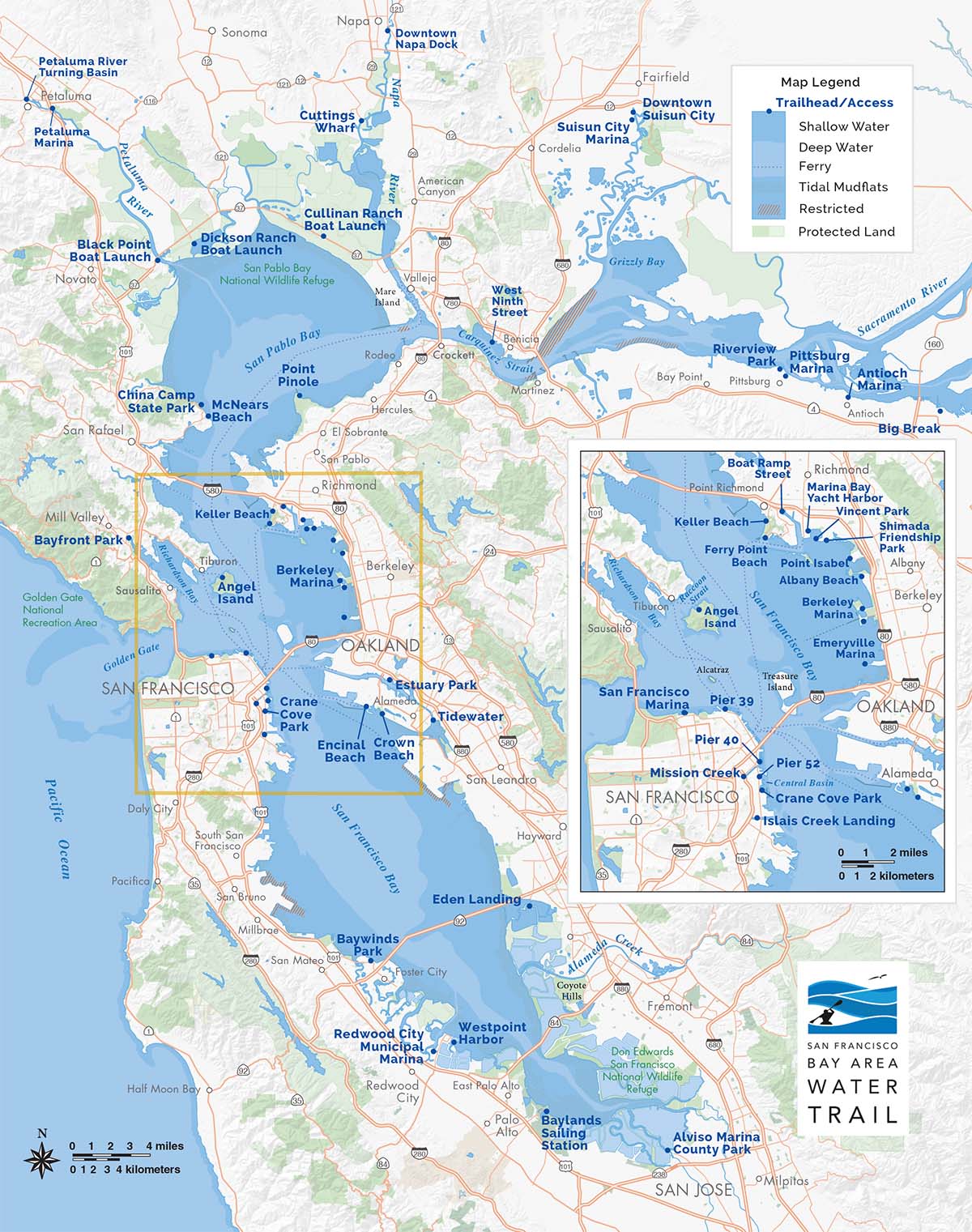
Crane Cove Park
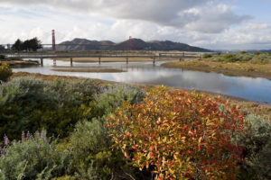
Crane Cove Park, located in San Francisco’s Dogpatch neighborhood, debuted as the newest trailhead on the Bay Water Trail map in September 2020. The site, managed by the Port of San Francisco, now boasts a seven-acre urban destination featuring a sandy beach, a sizable open green lawn with outdoor benches, and a barbecue and picnic area. The park is named for the two tower cranes that serve as prominent landmarks and a reminder of the area’s industrial maritime history. The old concrete boat slipway has been converted into a scenic overlook for the beach area and Bay.The Water Trail program worked closely with the port throughout the design of the park to provide convenient access to the water. The neighborhood hub is a launch point for the exploration of the southern San Francisco waterfront.
Local organizations and clubs near trailheads sometimes offer small craft rentals and classes as a way to encourage an adventure out on the Bay. Within days of Crane Cove’s opening, a local entrepreneur filled that niche. “I lived in my apartment for 11 years right across the street from Crane Cove. I was promised there would be a park,” says Adam Zolot, owner of Dogpatch Paddle. “It’s a pretty amazing space.” Prior to the new development, he says, the once industrial area was a barren feeding ground for raccoons, cats, and rats.
Remember, they are an exotic species in the Western United States, and are rapidly increasing their geographic range and range of habitats. Are they outcompeting or excluding native species in the process? How would we know? We have done almost nothing to monitor changes in the assemblage of mushroom species in areas before and and after the incursion of death caps.
Further Reading
Pringle et al, “The ectomycorrhizal fungus Amanita phalloides was introduced and is expanding its range on the west coast of North America,” Molecular Biology 2009
Lockhart et al, “Simultaneous emergence of multidrug-resistant Candida auris on 3 continents confirmed by whole-genome sequencing and epidemiological analyses,” Clinical Infectious Diseases 2017
Battalani et al, “Aflatoxin B1 contamination in maize in Europe increases due to climate change,” Scientific Reports 2016
» Plan your trip with the San Francisco Bay Water Trail website, SFBayWaterTrail.org.
» Crane Cove Park is located at Illinois and 18th streets, San Francisco. Street parking and Muni Metro Light Rail service are available.
» The cove currently has portable restrooms and a handwashing station, but stay current on new developments at SFPort.com/CraneCovePark.
Zolot has worked in the adventure travel business since the ’90s, with trips focused on scuba diving, kayaking, and trekking in Southeast Asia. He was planning to move his business digital when the tragic events of September 11, 2001, severely curbed travel to the region. He closed the business in 2003. Before the COVID-19 pandemic, Zolot was preparing to launch an online platform for wine country tasting rooms. Once again, the travel industry took another hit from a world disaster, and he closed down the project.
“I spent 2020 locked at home, sheltering in place. I spent my time, as much as possible, collecting my thoughts out on the water,” Zolot reflects. “Prior to the opening of Crane Cove, I would launch at Pier 52. I kept my [paddle]board strapped to the roof of my car pretty much the entire pandemic.”
Using the Bay as a respite in the pandemic, Zolot became intimate with the central and southern waterfront, its hazards, tides, and currents. “I would be out there alone. There would be kayakers that made their way from Islais Creek, but not a lot of paddleboarders.”
The conditions of the Bay can change swiftly, and it’s easy to get swept out into uncomfortable, potentially dangerous waters. But in his familiarity with the area, Zolot felt he had knowledge to offer. On the day Crane Cove Park opened, he created Dogpatch Paddle Club as a community resource for anyone interested in sharing information on safety, routes, and having a social connection. He posted on the NextDoor website, and dozens of people responded, ranging in experience from paddle enthusiasts to people who’d never paddled but were curious. From the initial post, a few dozen has mushroomed into over 900 members.
There was no business angle behind the club until he started fielding requests for equipment rentals and lessons. Then, in November, he learned about the port’s request for proposal to repurpose two buildings within the park, one for watercraft rental, storage, and retail. As an entrepreneur for many years, having no job and no business prospects, Zolot threw his paddleboard in the ring.
While Zolot still waits to hear about his own proposal, he’s decided to test the waters. He was already coordinating board sales through the club, so he purchased a few extra boards and started teaching lessons during weekends. The response was astounding. People were booking his time as much as he was making it available.
Then he was fielding requests for kids’ camps. As soon as he posted a summer camp, he booked 11 weeks of sessions and added a spring camp. Zolot acted quickly by renting a small retail space across from the park, opening 72 hours before camp started. He bought more boards and kayaks, built a website with a booking system, and hired instructors. Unfortunately, the neighborhood doesn’t have grocery or convenience stores, so he added the last piece of the puzzle: concessions of cold beverages, healthy treats, and a soft-serve ice cream machine.
“Understand the conditions under which you’re about to embark, start slow, and build confidence,” suggests Zolot about paddleboarding in Crane Cove. “The easy way, the shortcut, is to take one of our lessons.”
No Experience Like Firsthand
On an overcast Sunday morning, I met my friend Jean at the Ferry Building. I booked a group stand-up paddleboard lesson at Dogpatch Paddle. We biked the Bay Trail to Crane Cove Park for my inaugural San Francisco Bay water adventure. Not counting splashing around in lakes and streams, I couldn’t remember the last time I went swimming as an adult. To say I was anxious and nervous would be a gross understatement.
The four other participants in the group had had various experiences with canoeing, kayaking, and paddleboarding. Everyone was friendly and encouraging and pledged it would be fun. I set the bar for success pretty low: don’t fall in. Our instructor brought our boards from the shop and laid them out on the beach. After 20 minutes of introductory instructions on dry land, we set out to launch our boards.
The beach area was full of people enjoying the new recreational area. With my life vest strapped tight, I gently walked out into the water and propped myself on my knees on top of the board. I listened intently to further instructions on how to paddle straight and turn and to pay attention to the board’s nose, which could shift directions with the wind.
It was difficult for me to grasp the concept of doing the opposite: to move right, I needed to paddle on the left and vice versa; to turn right, I needed to skim my paddle on the water from front to back, and to go left, skim back to front, all while being aware of not drifting too far out.
Our instructor was attentive and kept a watchful eye. I stayed within earshot so I could re-ask the same questions over and over: how do I…? After 45 minutes, I felt like I had a basic grasp of how to maneuver. I was winning. My excitement dampened when the instructor said, “Alright, we are going to paddle out along the Central Basin.” I hovered near the beach, not wanting to go farther afield. Our instructor rallied me to give it a try: it’s not as bad as you think. I stayed kneeling as others stood up and paddled away. He floated next to me, chatting about everything but paddleboarding, a great distraction technique. I started to loosen up before registering we were a few miles from the beach.
With my paddle in my lap, I looked out toward the East Bay, taking in the magnificent view. As the wind picked up, we headed back to the beach. It was a success; I didn’t fall in. It was a terrific experience. Afterwards I told anyone who would listen what a great time I had for my first Bay Water Trail outing. Now, I have several invitations to go out again. My bar for success has budged slightly. Perhaps I’ll try standing up next time.
What’s On the Horizon?
Currently, the San Francisco Bay Area Water Trail is working through recommendations on its ADA accessibility plan. It recently provided a grant to the East Bay Regional Park District to provide an ADA point of access from the water to the campground at Point Pinole Regional Shoreline.
The trail program is teaming with shoreline nonprofits and organizations such as Petaluma Small Craft Center to provide accessible facilities and low-cost rentals. Other endeavors involve working with nonprofit groups Environmental Traveling Companions in San Francisco and Literacy for Environmental Justice in southeast San Francisco’s Bayview–Hunters Point neighborhood to offer opportunities to all.
“It’s about supporting our partners and providing grants where we can to help facilitate programs that allow more people to experience the Water Trail,” Botkin offers. “As the Bay Area’s population grows and as redevelopment is occurring, it is so important that we maintain and enhance this incredible shoreline recreational asset.”