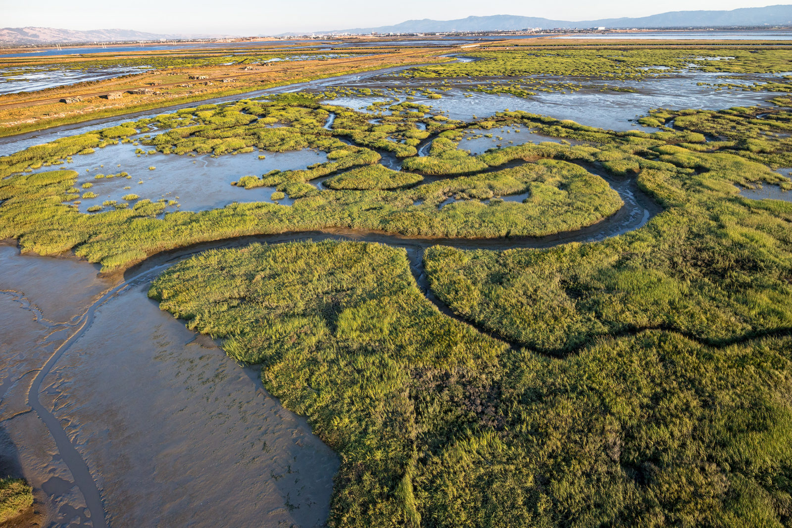
For centuries, San Francisco Bay’s wetlands were one of the richest ecosystems in the world. It’s estimated that 250 years ago the Bay was bounded by 200,000 acres of wetlands—lush habitat that provided a home for birds, fish, and other wildlife and that served as the basis of life for the Ohlone people who made, and still make, their home around the Bay. In the centuries since, 80 percent of these wetlands have been lost to development. That’s been devastating to wildlife. And because wetlands filter water impurities and help control erosion and flooding, it’s made Bay Area communities more vulnerable—especially as climate change brings rising sea levels. Assessments of the worst-case scenario predict the Bay may rise a damaging 1.9 feet by 2050 and as much as nearly 7 feet by 2100. Restoring even a fraction of the Bay’s lost wetlands would provide long-lasting benefits.
FUNDS AT WORK
A few of the Measure AA–funded projects underway:
• South Bay Salt Ponds Restoration Project, South Bay and East Bay
• Heron’s Head Park Shoreline Resilience Project, West Bay
• Montezuma Tidal and Seasonal Wetlands Restoration Project, North Bay
• Coyote Hills Restoration and Public Access Project, East Bay
• Lower Walnut Creek Restoration Project, East Bay
• Encinal Dune Restoration and Public Access, East Bay
That’s where Measure AA, adopted four years ago, comes in. While some significant Bay wetland restoration projects were already underway, Measure AA proponents believed that additional funding was urgently needed. So did Bay Area voters: in 2016 residents in all nine Bay Area counties approved this parcel tax that over 20 years will provide $500 million to restore San Francisco Bay wetlands and implement flood protection and shoreline access projects that support wildlife habitats. An existing regional agency, San Francisco Bay Restoration Authority, administers the funds. Because wetland restoration projects are often slowed by the need to navigate complex regulatory processes, the Authority worked with other partners to create the Bay Restoration Regulatory Integration Team. The BRRIT brings together six regulatory agencies with the collective aim of efficiently evaluating and permitting projects eligible for Measure AA money.
The need for wetland restoration has become even more pressing as climate change’s effects on the Bay have become increasingly apparent. “There’s more urgency to get this work done than people often realize,” says Dave Pine, a San Mateo County supervisor and chair of the Authority’s governing board. “The scientific community has made it clear that if we don’t make significant headway over the next decade or so, many of the restoration sites will become flooded due to sea level rise and will become much more costly to restore.”
Around the Bay, so far 17 projects have been funded and have brought not only environmental benefits, but employment, too. The Authority estimates that Measure AA funding will generate between 11,200 and 15,000 jobs over 20 years. Three current projects—in the North Bay, East Bay, and South Bay—demonstrate the range and importance of the work being done.

Tiscornia Marsh, San Rafael
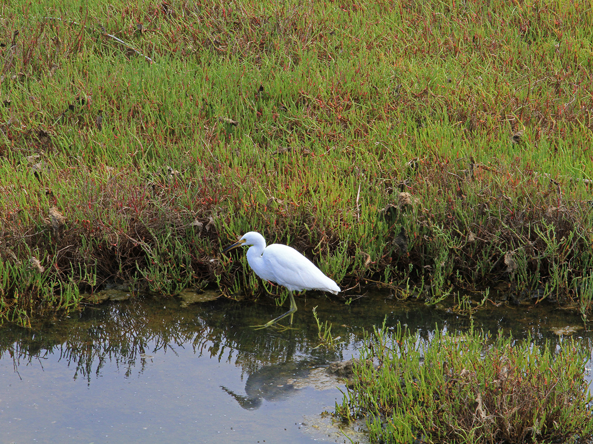
This tranquil Marin County wetland lies at the mouth of the San Rafael Canal. Pacific cordgrass and pickleweed rustle in the breeze, and great blue herons and snowy egrets wade in the tidal marsh. Not far away is San Rafael’s Canal neighborhood, home to a large community of immigrant families.
Both the marsh and the adjacent neighborhood are threatened. One-third of Tiscornia’s wetlands have eroded over the last 30 years, says Barbara Salzman, president of the board of directors of the Marin Audubon Society. In addition, the levees adjacent to the tidal marsh are in need of strengthening and raising. “If the marsh keeps eroding, the Bay will be lapping up against the levees, which will undermine them,” Salzman says.
In that way the loss of wetlands has increased the flood risk to the low-lying Canal neighborhood, which includes housing and an elementary school near the shoreline. It has also reduced the populations of wildlife, including the endangered California Ridgway’s rail, which relies on the tidal marsh’s Pacific cordgrass for shelter and nesting.
Remember, they are an exotic species in the Western United States, and are rapidly increasing their geographic range and range of habitats. Are they outcompeting or excluding native species in the process? How would we know? We have done almost nothing to monitor changes in the assemblage of mushroom species in areas before and and after the incursion of death caps.
Further Reading
Pringle et al, “The ectomycorrhizal fungus Amanita phalloides was introduced and is expanding its range on the west coast of North America,” Molecular Biology 2009
Lockhart et al, “Simultaneous emergence of multidrug-resistant Candida auris on 3 continents confirmed by whole-genome sequencing and epidemiological analyses,” Clinical Infectious Diseases 2017
Battalani et al, “Aflatoxin B1 contamination in maize in Europe increases due to climate change,” Scientific Reports 2016
Pay a visit: From the Albert J. Boro Community Center on Canal Street in San Rafael, walk approximately 30 feet east to see Tiscornia Marsh. For a longer walk, park near the Richmond Bridge and walk approximately a mile north along the shoreline and the San Francisco Bay Trail.
In 2018 Marin Audubon received funding from the Marin Community Foundation to work with the Multicultural Center of Marin, a Canal neighborhood organization, and a team of engineers to develop a plan for mitigating the effects of climate change on Tiscornia Marsh. In 2019, a round of AA monies ($968,916) pushed the project further along.
The project will restore and expand the 20-acre marsh by depositing sediment, hopefully from local dredging projects, to serve as home to native tidal marsh plants. The Canal neighborhood will gain protection from raising of the levees around the marsh. There will be improved public shoreline access via a new recreational path, part of the San Francisco Bay Trail, that will run along the top of one of the levees. The proposed project will also restore and expand tidal marsh by breaching the levee around six adjacent acres of diked wetlands owned by the city of San Rafael.
The project planning stage—refining the design, conducting technical assessments, performing technical studies, and producing an environmental impact report—is on track, says Audubon’s Salzman. The Measure AA grant also includes funds for the Multicultural Center of Marin to work with local youth on creating community engagement with the project—a reminder that wetland restoration can benefit San Francisco Bay in many different ways.
South San Francisco Bay Shoreline Project
Alviso is one of the Bay Area’s least-known recreational riches. Once a separate town, now part of San Jose, it borders Coyote Creek, the Guadalupe River, and San Francisco Bay. Miles of trails draw bird and wildlife watchers, hikers, runners, and cyclists.
Still, the area has changed over the decades. Richard P. Santos, who grew up in Alviso in the 1940s and 1950s and who today serves on the board of directors for the Santa Clara Valley Water District (Valley Water), recalls the wildlife that used to fill the slough and the Bay. “There were mudhen, jackrabbits, and so many birds—egrets, mallards, seagulls, geese, and lots of pheasants,” he says. “The sturgeon would come right out of the water.”
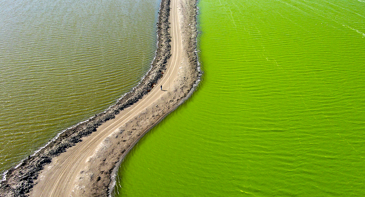
Wildlife has declined in the area for many reasons, including development, the conversion of wetlands to industrial salt evaporation ponds, and reduced water quality. The ponds at Alviso are no longer used for salt harvesting, but the effects linger. Species that once thrived in the area, such as the salt marsh harvest mouse and California Ridgway’s rail, are now endangered. Along with the area’s subsidence below sea level due to groundwater pumping, the loss of wetlands has made the Alviso neighborhood more vulnerable to flooding.
Now Alviso and this entire section of San Francisco Bay shoreline are recovering, due in part to Measure AA and the South San Francisco Bay Shoreline Project, as well as the South Bay Salt Pond Restoration Project, the largest wetlands restoration effort on the West Coast. A partnership between Valley Water, U.S. Army Corps of Engineers, California State Coastal Conservancy, and U.S. Fish and Wildlife Service and supported by other regional stakeholders, the Shoreline Project began in 2005. The $61 million in Measure AA funding allocated in 2018 and 2019 has enabled work to continue on levee construction, restoration to tidal wetlands of 2,900 acres of former salt evaporation ponds, and improvement of shoreline access by closing a gap in the San Francisco Bay Trail.
Remember, they are an exotic species in the Western United States, and are rapidly increasing their geographic range and range of habitats. Are they outcompeting or excluding native species in the process? How would we know? We have done almost nothing to monitor changes in the assemblage of mushroom species in areas before and and after the incursion of death caps.
Further Reading
Pringle et al, “The ectomycorrhizal fungus Amanita phalloides was introduced and is expanding its range on the west coast of North America,” Molecular Biology 2009
Lockhart et al, “Simultaneous emergence of multidrug-resistant Candida auris on 3 continents confirmed by whole-genome sequencing and epidemiological analyses,” Clinical Infectious Diseases 2017
Battalani et al, “Aflatoxin B1 contamination in maize in Europe increases due to climate change,” Scientific Reports 2016
Pay a visit: Visitors can enjoy Alviso while birdwatching, hiking, or biking on the San Francisco Bay Trail. Good jumping-off points are Alviso Marina County Park on Hope Street or the Don Edwards San Francisco Bay National Wildlife Refuge’s Environmental Education Center on Grand Boulevard.
It’s a long-term project. In 2021, work will begin on a four-mile engineered levee along the edges of ponds A12, 13, 16, and 18; once the levee is finished, in 2024, the first of three phases of the salt pond restoration will begin. An ecotone slope—a habitat that gradually transitions with elevation from subtidal waters to intertidal mudflats to marsh before culminating in a layer of upland plants covering the levees—will be constructed. Berms will be breached to open the salt ponds to Bay tidal flows. Tidal wetland vegetation such as cordgrass and pickleweed will colonize the restored wetlands. The ecotone will also be planted with species like gum plant and marsh rosemary that grow between the marsh and higher ground.
“Once the ponds are opened up, they will act as nurseries for fish such as steelhead and nurse sharks and a lot of the endangered birds,” says Valley Water’s Rechelle Blank, deputy operating officer for South San Francisco Bay Shoreline Project.
And the closing of the gap in the San Francisco Bay Trail—four miles between the Don Edwards Wildlife Refuge and Coyote Creek—is good news for hikers and cyclists, too.
North Richmond Shoreline Living Levee Project
If all goes as planned, in a decade the San Francisco Bay shoreline along North Richmond will be graced by a new, wetlands-friendly landmark: a half-mile levee built perpendicular to the tide. And not a usual levee. Sloped toward the water, it will be planted with brackish, saltwater-loving plants closest to the Bay, transitioning to an upland habitat as it moves inland.
This “living levee” is a unique solution to an all-too-common Bay crisis. By 2050, the tidal and wetland marshes lining the North Richmond shoreline, a stretch from Castro Cove to Point Pinole Regional Shoreline, will be at risk of being submerged by sea level rise. That would remove habitat for existing marsh plants and wildlife and jeopardize the North Richmond community, which includes many low-income residents already exposed to human-made environmental hazards through brownfields, illegal dumping, and oil refinery emissions.
Remember, they are an exotic species in the Western United States, and are rapidly increasing their geographic range and range of habitats. Are they outcompeting or excluding native species in the process? How would we know? We have done almost nothing to monitor changes in the assemblage of mushroom species in areas before and and after the incursion of death caps.
Further Reading
Pringle et al, “The ectomycorrhizal fungus Amanita phalloides was introduced and is expanding its range on the west coast of North America,” Molecular Biology 2009
Lockhart et al, “Simultaneous emergence of multidrug-resistant Candida auris on 3 continents confirmed by whole-genome sequencing and epidemiological analyses,” Clinical Infectious Diseases 2017
Battalani et al, “Aflatoxin B1 contamination in maize in Europe increases due to climate change,” Scientific Reports 2016
Pay a visit: Hikers and bikers can see the heart of the proposed project site along the San Francisco Bay Trail’s Wildcat Marsh Trail, accessible from the East Bay Regional Park District’s Wildcat Marsh Staging Area parking lot, off the Richmond Parkway.
It was these threats that in 2017 pushed the San Francisco Estuary Partnership (SFEP) to work with the San Francisco Estuary Institute and The Watershed Project on developing a vision of a North Richmond shoreline that considers both habitat transition and community economic benefits, including creation of local jobs.
The levee concept, earlier piloted in Hayward in 2015, was advanced as a solution for Richmond through a yearlong Resilient by Design Challenge, initiated in fall 2017 and facilitated by design firm Mithun, along with local leaders and a community advisory board. This past spring, the levee project received $645,000 of Measure AA funding for planning, preliminary designs, technical and feasibility studies, and community engagement efforts.
“The goal for this project is to achieve habitat creation, flood protection behind the levee, and improved public access,” says Josh Bradt, a SFEP project manager and watershed specialist managing the grant contract between the Wastewater District and the Authority.