.jpg)
When I was growing up in New York City in the 1950s and ’60s, my family got around town by bus, subway, taxi, or on foot. We had a car that spent most of its time in a commercial garage five blocks from our apartment; we used it mostly for trips to “the country,” as we called it, for nature walks and picnics. Those were major excursions.
When I moved to San Francisco in 1973, I was thrilled to have so many great places to hike nearby. No more “long haul” to “the country”! But I missed New York’s robust public transit system that ran everywhere, all day, every day, and frequently. Why didn’t (and doesn’t) this cosmopolitan Bay region have a ubiquitous transit system that does more than get people to city centers? Unlike in New York City, here I could actually see “the country” from the city. Wild places like Mount Tam, Mount Diablo, the East Bay hills, and the Santa Cruz Mountains beckoned from almost every part of the city. But I still needed a car to get to them.
Or so I thought.
What I didn’t know was that there actually are trails and parks you can get to without taking a car. In 2001, Bay Nature published an updated version of the Bay Area Open Space Council’s “Transit Outdoors” map, originally created in 1995. Now, eight years later, we’re glad to present the latest update of this regional roundup of parks and trails you can visit while leaving your car at home. We invite you to use it as your starting point for all sorts of car-free out-door adventures around the region, from easy half-day outings on the edge of town to overnight backpacking trips in the backcountry.

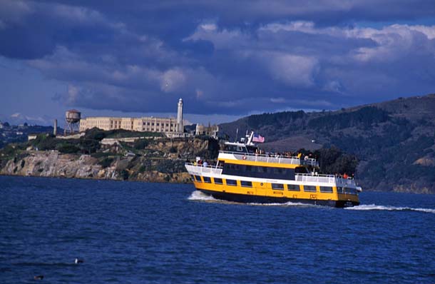
- Blue & Gold Ferry passing by Alcatraz. Photo by Bob Ecker.
I wish I could report that there are many more options for car-free nature excursions now than in 2001. There certainly were more options before the personal car became king in the mid-20th century. But then again, there were far fewer public parks and preserves in those days. Now, in 2009, we have over one million glorious acres of protected open space in the Bay Area, much of it open and accessible to the public . . . if you have access to a car. It’s generally not too hard to use transit to get to work or to go shopping. But it can be a real challenge to reach the parks and open space that are “yours” by virtue of residency and taxes.
Yet, as you can see from this updated “Transit to Trails” map, plenty of opportunities do exist. Some of the suggested outings are in the region’s urban core, such as sections of the Bay Trail with expansive views, shorebirds aplenty, and great bike and stroller access. But many of these transit-accessible hikes are really “out in the country” and–as one-way trips–give you the opportunity to cover more ground than if you had to turn around and retrace your steps to the parking lot. There are other benefits to leaving the car at home, such as being able to take a post-hike nap while you let the bus driver deal with the traffic. It’s true that gasoline prices plummeted back down to 2001 levels late last year (2008), but you know that won’t last. So you can add saving money to the benefits.
Ultimately, though, we all know the biggest payoff for taking transit: the health of the planet and all living things, including us. Climate change is a reality, it is happening here and now, and already altering our local ecosystems. (See “Taking the Heat: Bay Area Ecosystems in the Age of Climate Change ” in the January-March 2009 issue of Bay Nature.) And those of us who drive to the park in our cars are part of the problem. According to the Bay Area Air Quality Management District, 41 percent of greenhouse gas emissions in the Bay Area come from transportation, with 64 percent of that coming from autos and light-duty trucks. Given that 75 percent of these motor vehicle trips are not work related, our personal driving habits have a huge impact. Reducing our “vehicle miles traveled” can take a big bite out of the Bay Area’s carbon footprint and make a big difference in the health of those natural places we love to visit.
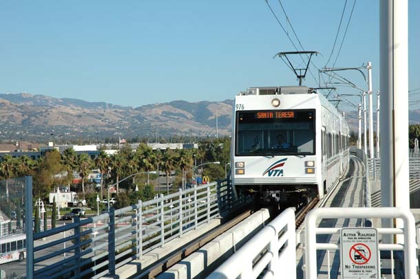
- Santa Clara VTA light rail at Great Mall/Main Station (Milpitas), with Mount Hamilton behind. Photo courtesy Santa Clara Valley Transit Authority.
I’m as guilty as the next person. All week I bike to work, leave the car at home, and wear a halo. But come the weekend, I load up the car with my hiking boots, lunch, and friends, and head off to another great place to explore.
What will it take to get us out of our cars? Certainly more extensive transit coverage and weekend service would help. But in the mean-time, another major barrier to car-free outings is coming down: lack of information. With the revamped “Transit Trip Planner” on the 511.org website (sponsored by the Metropolitan Transportation Commission), it is now not only possible but easy to get up-to-date transit directions (including schedules, time, cost, and walking directions) to and from almost any point within the nine-county Bay Area. And an Open Space Council-sponsored website launching later this year, transitandtrails.org, will incorporate selected trailheads (including the ones highlighted in this publication) into a 511-linked trip planner.
Of course, not every place you’ll want to go is transit-accessible (yet), but with the information provided by “Transit to Trails” and these new online resources, you can find out which places are accessible, and then make “getting there” part of the adventure. And part of the solution.
Note: Transit routes and schedules change frequently, and are not the same every day of the week, so it is important to check 511.org (or call 511) for the latest information before you head out.
-300x225.jpg)
-300x201.jpg)