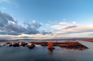
I’m standing on a levee near the edge of the Bay, just south of where the San Mateo Bridge touches down in the East Bay. There’s a ribbon of tidal marsh on one side of me and an expanse of mud on the other. The air smells like salt, a steady breeze blows inland, and the sky is a cloudless pale blue. This beautiful spot, fittingly called the marsh viewing area, is on a new trail in the Eden Landing Ecological Reserve near Hayward, where 6,400 acres of salt ponds are being restored to marsh and shorebird habitat.
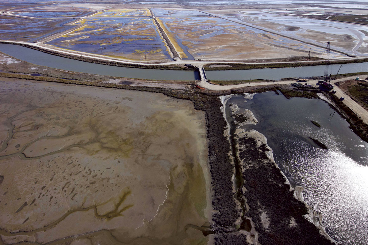
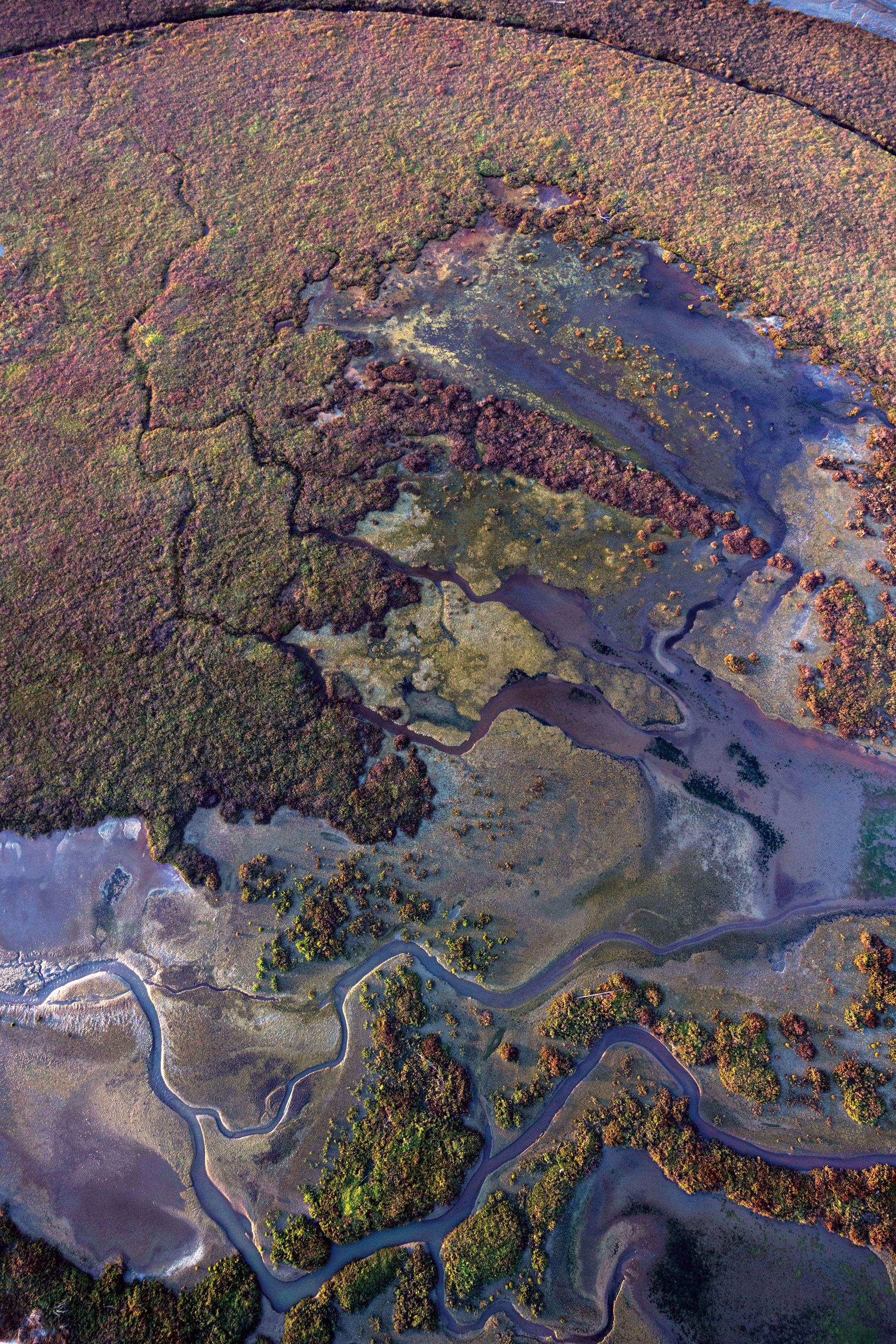
The tide is out, exposing the chocolate-brown mud along the tidal channels, which cut through the muted greens of the pickleweed and cordgrass that cover the marsh. Water mirrors the blue of the sky and zigzags along channels toward the Bay. Dodder—a native parasitic vine that looks like a tangle of thread—adds splashes of Day-Glo orange. But pretty as the marsh is, my eyes are drawn to something else.
A patch of mud is crammed with tiny pointy spiral shells, such a multitude that you have to see it to believe it. There must be hundreds. “Snails,” says John Krause, a California Department of Fish and Wildlife (CDFW) biologist who manages the reserve, adding that tidal marshes are rich with life. “A square meter of mud contains millions of critters.” Farther along, a mud bank is dotted with small round holes and I ask what they are. “Crab burrows,” says John Bourgeois, smiling at my delight. Bourgeois manages the South Bay Salt Pond Restoration Project that is revitalizing 15,100 acres at three sites, including the reserve we’re exploring.
The marsh viewing area is halfway into the new Eden Landing Trail, a 3.8-mile loop that opened to the public last spring. Along with the new trail, the project includes a new kayak launch, 230 acres of salt ponds where shorebirds forage and rest, remnants of the saltworks where Japanese workers labored a century ago, and 630 acres of tidal marsh in various stages of restoration. The opening comes after about eight years and $32 million of restoration work led by CDFW, the California State Coastal Conservancy, and the U.S. Fish and Wildlife Service; Ducks Unlimited did much of the design and construction. Next, planners will turn to restoring the 2,200 acres of salt ponds south of the new trail, between Old Alameda Creek and the Alameda Creek Flood Control Channel. Restoration there could start in 2020.
From the trailhead at the end of Eden Landing Road, there is little sign of the natural beauty to come at the marsh viewing area. The trail is part of the San Francisco Bay Trail, and here warehouses come all the way to the landward edge of the reserve. The new trail—suitable for bicycling as well as walking—begins as a paved road flanked by a barren-looking mudflat. But in just a quarter mile, we reach the new kayak launch on the banks of Mount Eden Creek, which flows into the Bay. The launch will become part of the San Francisco Bay Area Water Trail this fall.
A small bridge crosses the creek and leads to a gravel path along 100-year-old levees that circle Eden Landing’s salt ponds. These former commercial salt ponds were established on natural ones. “Crystal salt ponds were scattered across the marsh plain and landward edge. Native Americans harvested salt from them,” says Robin Grossinger, a historical ecologist with the San Francisco Estuary Institute who has reconstructed the pre-European settlement ecology of sections of the Bay shore. The Ohlone gathered salt from shoreline rocks, burned marsh plants for their salty ash, and put willow twigs in the briny ponds to collect the salt crystals that grew on them.
Before commercial salt production began in the mid-1800s, Eden Landing was part of a huge swath of tidal marsh along the South Bay. “There was a continuous band of tidal marshland from San Leandro all the way to Foster City,” Grossinger says. By the 1930s, however, nearly half of the South Bay’s historical tidal marshes had been converted to salt ponds. Those at Eden Landing were commercially operated until 2003, when state and federal governments bought the land for the South Bay Salt Pond Restoration Project.
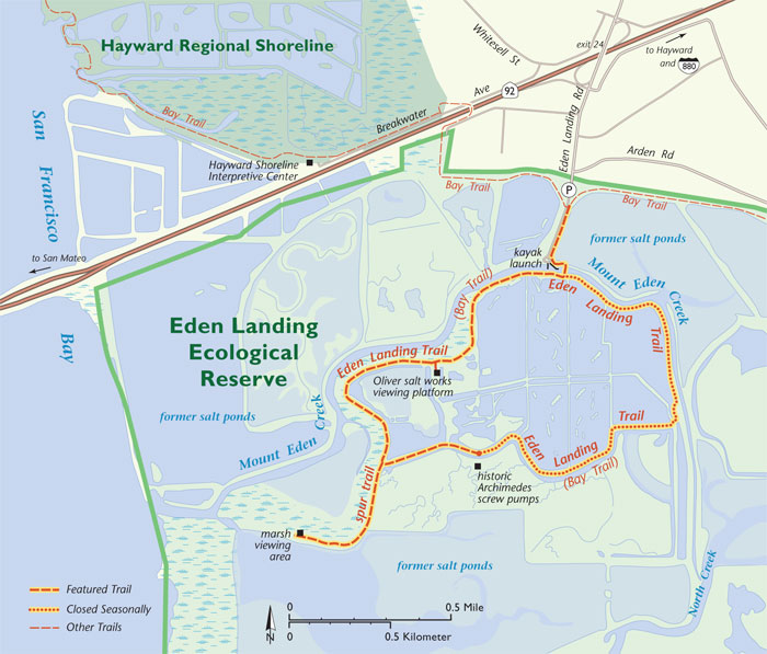
Most of the Eden Landing salt ponds will be restored to tidal marsh, but some have been kept for shorebirds, and the trail loops around the 230-acre repurposed pond. “All shorebirds use the ponds, but some are salt pond specialists,” Bourgeois tells me, mentioning the red-necked phalarope and the snowy plover, a threatened species, as examples. “We didn’t want to take away their habitat.” Today, long-legged avocets hunt the shallow waters for creatures to eat. A tern, wheeling overhead in a flash of white, bears a tiny fish in its beak. And twice a year, in early spring and again in late summer to fall, millions of migrating shorebirds converge on the Bay.
The shorebird pond is subdivided into cells that take advantage of the structure that remains from the salt-making process, where seawater moved through a series of evaporation ponds to concentrate the salt. “It’s a giant experiment,” Bourgeois says. “We don’t know how salty the birds like the water.” The highest concentration is three times that of the Bay, and it shows: As the water’s salinity increases in the cells, their algae changes from green to orange-red. Near the trailhead, where the salinity is lowest, the pond is an opaque blue. But on the far side, the water is such an intense yellow it glows as the sun shines through. The saltiest water is also thick with brine shrimp and other invertebrates, providing a feast for the birds.
At about six inches deep, the pond suits shorebirds with the longest legs. But here and there around the shorebird pond, bits of higher ground rise slightly above the water’s surface. Shorter shorebirds need shallower water, and these mounds provide a range of depths. Krause, the reserve manager, adds that when the tide comes in, some mounds may go under but others always stay dry to entice nesting birds. Snowy plovers are nesting there now, he tells me, and while I don’t see any, I do see the oyster shells put there to help protect chicks from the ravens, peregrine falcons, and other birds that prey on them. Snowy plovers are small birds—“the size of your fist,” says Krause, closing his fingers to demonstrate—and their chicks can hide under an oyster shell with room to spare.
Pieces of wood also poke out of the pond water in long lines that seem to vanish across the pond. They must have had a purpose but it’s hard to imagine what. Given what I’ve learned so far, though, maybe I should have been able to guess: It turns out they are what remains of low walls built long ago to divide the commercial salt ponds into cells. Strange as these wooden relics look, they are nothing compared to what comes next.
To me, it’s like the set of a postapocalyptic movie. Krause calls it a moonscape. Merge the two and you’ll know what to expect at the Oliver Salt Works, abandoned in the 1920s and crumbling ever since. An elevated boardwalk takes us from the trail and leads us up over ground so cracked and salt-crusted it feels like an eternal wasteland. Remarkably, snowy plovers choose to nest here—they like white, sandy beaches and this is close enough.
All around the boardwalk lie stubs of weathered wood, concrete, and corroded metal, ghosts of the long, narrow evaporation ponds and the hodgepodge of buildings that packed this site a century ago. There’s not much left, but it’s enough to sense the toil of the Japanese men who moved water from pond to pond and shoveled their crystalline harvest into wheelbarrows. The conversion process was lengthy, taking five years to get from seawater to table salt and yielding about 40 tons per acre.
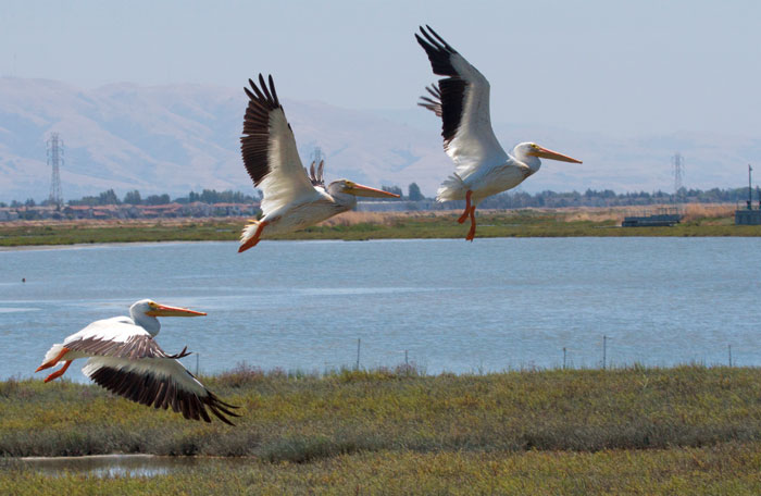
Down the trail from the old salt works, a short spur leads to the marsh viewing area. There, I see 30 white pelicans sail low over the marsh and slowly sink out of sight. My last glimpse is the striking black of wingtips against shiny white and then they’re gone. Wait, what just happened? As salt ponds transform back into tidal marsh,“deep channels scour into the landscape,” Krause says, explaining that strong tidal currents from the Bay erode sediment. Some channels are already 10 feet deep and 20 feet wide, plenty of room to hold a flock of birds even when they’re as big as pelicans.
Bourgeois likes to come here in the spring, just as the tide starts to go out. “It’s the best time to see shorebirds eat—they hang out on levees waiting,” he says. Krause adds that he also likes it when the tide comes in. “It brings little fish, and big fish follow the little fish, and harbor seals follow the big fish,” he says. Seals come all the way into the reserve and haul out on the marshes.
Back on the trail, we encounter more ramshackle wooden structures. Tall and angled, these were Archimedes screw pumps, wind-powered devices that once moved water from one salt pond to another. They stand on the dry bed of a salt pond with the same moonscape look of the salt works. This repurposed pond is designed for breeding birds, and last year about 100 pairs of snowy plovers nested here.
Plovers abandon their nests if people come near, so the loop here closes during their breeding season, which is usually April to late summer. “The ponds were designed to attract nesting birds, so we didn’t want to surround them 360 degrees with people,” Bourgeois says. Once again, I don’t see any plovers, but I do hear the plaintive cries of a pair of avocets. Then I notice their chick: Leggy and long-necked like its parents, but it’s a fluffy brownish gray rather than the sleek cinnamon, cream, and black of adults. The avocets’ distress makes me glad this part of the trail is closed now.
Soon we’ve circled back to the mudflat at the trailhead, and I see it with new eyes. Far from being barren, this is land on its way to becoming tidal marsh. Beginning in 2006, levees between the Bay and Eden Landing were breached to let the tide flow back into the reserve and rebuild the marshland. “A monumental amount of sediment has been restored via Mount Eden Creek,” Bourgeois says, adding that once the marshland is high enough, pickleweed and many other native plants will begin to grow on their own. “If you walk here over a number of years, you’ll see continuous changes, and in 20 years we expect it to be mostly vegetated.”
Salt ponds are relatively easy to restore, Bourgeois explains, because the basic tidal marsh landforms are not gone, they’re just buried. “The channels are still there and now they’re showing up again,” he says. “It’s not like laser-leveled fields in the Central Valley,” Krause adds. “People just put fences around the salt ponds.” The transition between marsh and upland is another story. In the transition zone along the new trail’s entry road, as well as on some levees, Save the Bay and the Invasive Spartina Project planted native species, including alkali heath and marsh gumplant. Save the Bay also weeds and hand-waters these young plants. Healthy tidal marsh provides a natural buffer against flooding and sea level rise.
For guidance on restoring tidal marsh at Eden Landing, Bourgeois and Krause turned to historical ecologist Grossinger. According to historical documents—including maps, photographs, and travelers’ accounts—Eden Landing’s marsh originally stretched four miles from solid land to Bay. “It was a really huge expanse of tidal marsh,” Grossinger says. “The Bay came almost up to where 880 is now.” The giant marsh was fed by the alluvial fans of two creeks, Alameda and San Lorenzo, that flanked it to the south and north. While Alameda Creek has been channelized and now enters the Bay just south of the reserve, it once meandered through Eden Landing and, as the Bay Area’s largest creek, deposited tons of marsh-building sediment there.
“There was a tremendous network of tidal channels,” Grossinger says. “One hundred and seventy-two miles were directly connected to Alameda Creek.” End to end, the channels were more than twice as long as the Bay itself and, incredibly, they all fit into just a few square miles of marsh. His map of Eden Landing’s historical tidal channels helped jump-start the restoration. The major channels were lightly scored to get them started again, and now the tides are doing the rest. “The tidal channels will get close to their historical complexity,” Bourgeois says.
Already, two endangered species that live only in the tidal wetlands of the Bay Area are moving back to Eden Landing. Ridgway’s rails have returned to the Bay side of the reserve and salt marsh harvest mice to the landward side. As I look across the mudflat at the trailhead, I see the tidal marsh that once was and will be again. Already, I can see the intricate tracery of tidal channels that have begun to reclaim the land.

-300x226.jpg)