.jpg)
Somewhere back in our collective unconscious–before army engineers dredged a shallow trench to accommodate giant container ships at Oakland’s waterfront, before industrious men and women welded and riveted steel and iron to assemble Liberty ships at Point Richmond, before industrialists diked the South Bay’s marshes to harvest sea salt for a burgeoning population–dwells a primordial memory: one of Ohlone, Miwok, and Carquin living in densely populated encampments and navigating the Bay’s shores in vessels fashioned from tough stalks of tules to gather clams, mussels, Dungeness crab, and salmon and other fish.
Over the last 150 years people became increasingly cut off from the Bay as it converted from a natural wonder into an opportunity for development and an obstacle to traverse. That interlude of blindness has been lifting for a few decades, and now public agencies, private stakeholders, and intrepid outdoor enthusiasts have joined forces to rekindle the spirit of that ancient memory of silent boats plying the shoreline. On March 17, 2011, the California State Coastal Conservancy approved a multiyear environmental impact report and granted $1 million to the Association of Bay Area Governments to begin knitting together as many as 112 official launch sites for non-motorized water vessels–kayaks, canoes, rowboats, dragon boats, sailboards–into the newly designated San Francisco Bay Area Water Trail. It will join the Ridge and the Bay Trails to complete the trifecta of concentric public pathways around the Bay.

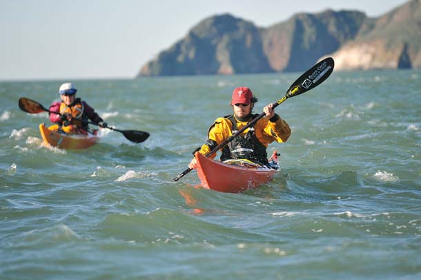
- Paddlers on the open Bay or just outside the Golden Gate (as here) face much more challenging–and exciting–conditions than paddlers in more sheltered waters. Photo by Larkin Donley, larkindonley.com.
More a series of launch sites than a linear course, the Water Trail offers adventures geared to every skill level. “If you want wild water you can find it,” says Penny Wells, president of Bay Access, a key nonprofit advocate for the project. “If you want to lollygag around and look at birds you can go to the back bays of San Pablo and the South Bay, where the water is calm and we have tremendous marshland.” Wells’ organization designed the wish list that became a blueprint for the trail: launch sites, parking, restrooms, places to rinse off and store equipment, campsites, and potential for other lodging, as well as maps of existing and proposed launch sites.
For Bay Access’s Casey Walker, who spent almost 30 years hiking local trails before he took up kayaking, being on the water opened up a new world. “It’s a unique way to be outside in the Bay Area,” he says. “Unless you’re sailing, you don’t acquire the knowledge of a mariner–the tides, fluid dynamics, and situations that specifically apply to the Bay.” Learning to read the tides–the inhale and exhale of the Bay–is a crucial part of that knowledge. “You have to head out with the ebb and come back with the incoming tide, especially around the Golden Gate Bridge, where tides are most powerful,” says Wells. “Conditions can go from mild to wild quickly.” Spring runoff and a new or full moon can double the average three knots that most paddlers travel. “The choicest kayaking is close to shore, observing the interaction of water and land,” she adds.
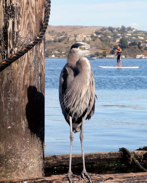
- A stand-up paddleboarder passes behind a great blue heron along the Sausalito waterfront in Richardson Bay. Photo by Diane Poslosky.
One of the Water Trail’s core existing sites is at Schoonmaker Beach in Sausalito, where day-trippers set out to explore the area’s picturesque harbors and houseboats and the more experienced paddlers venture around Yellow Bluff toward the Golden Gate or across Raccoon Strait to Angel Island. “Raccoon Strait is not as notorious as Yellow Bluff,” says Anne Kang, a member of Bay Area Sea Kayakers who has done the trip more than 30 times. “But depending on the tide and current you can get standing waves there too or be swept out toward the bridge. Heading out on a slack tide, between ebb and flood, is best.”
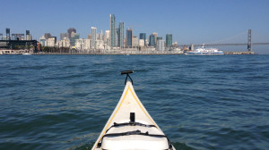
Despite its challenges, this trip is a favorite because of the perspective it offers on some of the Bay’s most breathtaking scenery. “The views of the city, the Golden Gate, and the Bay from the water are spectacular,” says Diane Poslosky, who runs Environmental Traveling Companions, an organization that leads outdoor adventure expeditions for people with special needs. “A month ago I was paddling to Angel Island with friends and we saw a raft of cormorants–more like a freeway of them–coming through the Golden Gate. There must have been thousands. It was absolutely stunning.” Harbor seals also make frequent appearances in these waters, following the progress of boaters. “They’re really curious but kind of shy,” Poslosky says. “They’ll pop up and when you notice them they’ll pop down quickly. You’ll turn around and there’s the harbor seal playing hide-and-seek with you.”
A milder adventure begins at the public dock at Jack London Square where California Canoe and Kayak offers classes for novices like me. From here we launch into the Oakland Inner Harbor, a nine-plus-mile inland waterway where giant cargo cranes preside over container docks at the north end and the channel merges with San Leandro Bay’s intertidal mud flat to the south. In the early 20th century, dredging operations here transformed what was once an isthmus into the island of Alameda. Midway down the channel is the slough, now heavily silted over and dammed, that connects Lake Merritt to the estuary and Bay. Thanks in part to dogged advocacy by Keith Miller, owner of California Canoe and Kayak, that channel will be daylighted next year with a kayak bypass as part of Oakland’s wetlands restoration project.
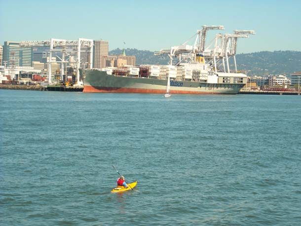
- Kayakers share the sheltered waters of the Oakland Estuary with giant container ships. Photo by Daniel Ramirez, Creative Commons.
Today’s journey will be brief–less than a mile down the southeasterly portion of the estuary. Because of the movement of container ships and security prohibitions near the shipping docks, the northern path along the Alameda side is off-limits to all but the most experienced paddlers. We wonder aloud what aquatic life braves this very urban setting. Although anglers here report catches of striped bass, perch, and even leopard shark, most of the nearly 70 species of fish found in the greater Bay tend to avoid these more enclosed waters.
But right on cue, a small silvery fish bursts out of the water. Most likely a juvenile being chased by something higher on the food chain, it is probably one of three kinds of fish that serve as regular appetizers for the estuary’s hungry waterfowl: sardines, northern anchovies, or possibly Pacific herring. Miller believes they’re most likely sardines: “I’ve leaned over the dock here in August and September and seen huge schools of them going through the marinas.” If he’s right, these swimmers are midway on a journey that takes them from Russia to Alaska and down to Baja’s Sea of Cortez.
The estuary’s landmarks, such as the old port terminal, Coast Guard Island, and Alameda’s cheery houseboats, provide historical context for paddlers continuing southward. A favorite event here is the full moon paddle, when the bright night sky illuminates the egrets, gulls, and night herons that line the docks. But perhaps the most exhilarating experience on these waters is that of simply reaching the southerly end of the estuary, where this narrow channel suddenly broadens out into the expansive San Leandro Bay. “For an urban paddling environment, it’s very cool,” says Miller.
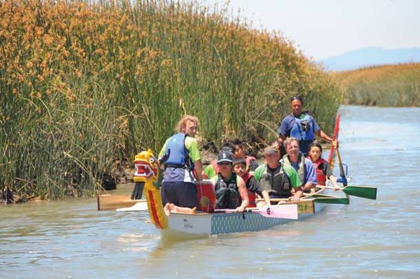
- People attending the grand opening of Alviso’s launch site paddle a dragon boat along the slough. The Water Trail will appeal to dragon boat teams, rowers, and other recreational boaters, in addition to kayakers. Photo by Patrick Lewis.
Down in the South Bay, just off Highway 237, past empty office buildings, and over the Gold Street Bridge, lies the tiny town of Alviso, situated along the Guadalupe River. It’s hard to imagine that such a place exists less than five miles from downtown San Jose.
The town–once a proud and busy port for commerce and the ferry system, a home for Wells Fargo Express carriages, and a construction site for Liberty ship hulls–became, literally, a backwater. In the mid-20th century, the local aquifer was pumped to provide fresh water to nearby cities and farms, causing the land closest to the Bay to subside 15 feet. Alviso’s most prominent designated historical landmark, the 115-year-old South Bay Yacht Club, had to be moved to higher ground. Protective levees built from recycled concrete were found to contain high amounts of asbestos, putting Alviso on the Superfund list and initiating a 25-year EPA cleanup effort. Alviso Slough is clogged with Gold Rush mining sediment that returned with the tides, inviting the growth of invasive grasses that have further choked the channel. Salt pond levees in surrounding marshes prevented the tidal action that could have scoured out the sediment.
With all these challenges, the marina appeared doomed. “Alviso used to be known as San Jose’s front door,” says Russ Robinson, the yacht club’s commodore and historian. “Over the years, that door was closed.”
But now, with a clean bill of health from the EPA and the South Bay Salt Pond Restoration Project opening up the neighboring areas to tidal action, Alviso’s resurrection has begun. In June 2010 nearly 1,000 local residents, civic leaders, and boating enthusiasts gathered at the Alviso Slough to inaugurate the new Alviso Marina Boat Launch Ramp. Funded by the California Department of Boating and Waterways, the ramp serves as a template for future launch sites. On opening day more than 400 people, including local children, took turns powering a colorful dragon boat, provided by the California Dragon Boat Association, through the slough.
Surrounding the new marina are observation decks, picnic areas, and many bicycle and walking trails. The best paddling here is at high tide, when you are less likely to get stuck on a mudflat. Launching from the new ramp into the slough one feels rather cozy, surrounded on either side by vegetation. The northwesterly wind, stronger in the summer months, offers a respite from the South Bay’s summer heat, but slows our forward progress. Except for the sight of Coyote Hills and the occasional auditory accompaniment of trains and jets, you could be in any quiet inland waterway.
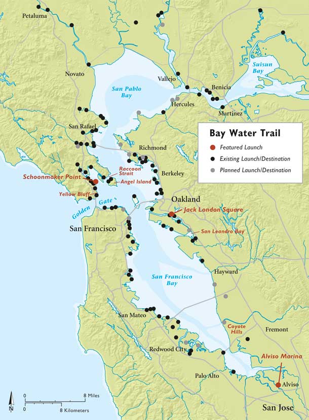
- Map by Ben Pease, peasepress.com. Click map for larger version.
And then it hits–the smell of salt air–a reminder of being connected to a larger body of water and to the sea. Soon the landscape changes as well. Tall, breezy cordgrass is replaced with pickleweed, critical habitat for the endangered salt marsh harvest mouse. Pickleweed is a hardy succulent with segmented fingerlings ranging from coral to pale green from which sprout tiny cream-colored oval florets. Like the cordgrass, pickleweed is a halophyte, or salt-tolerant plant, ideally suited to these wetlands and the harbinger of a healthier marsh.
Beehive-like mounds of salt line the levees. And everywhere–birds. Most of the migrating birds here, such as northern shovelers and greater yellowlegs, leave by April or May. “Some of our earliest might be coming back in July. Those are mostly shorebirds–like long-billed curlews,” says Cheryl Strong, wildlife biologist at Don Edwards San Francisco Bay National Wildlife Refuge. But permanent residents are abundant: “We see egrets and great blue herons in the channel year-round.”
In the distance a quiet roar announces a cut in the levee connecting the slough with a salt pond prosaically labeled A6. This mini white-water channel, occurring at the change between ebb and flood tides, is both exciting and awe-inspiring. The afternoon summer breeze picks up, and we take that as our cue to head back. A tailwind cuts the return trip in half.
Over the next few years, as Water Trail sites are developed and education programs get rolling, the thousands of people who climb into kayaks and other muscle-powered boats will learn firsthand why tides, tailwinds, and the preservation of our natural resources matter. “The number of people taking ownership of our Bay and caring for it will likely grow,” says Ann Buell, project manager for the Coastal Conservancy. “To get out on the Bay is to love and want to protect it and the wildlife it supports.” Thanks to Buell, Wells, and other advocates, more people will have the opportunity to appreciate the beauty, majesty, and joy of being out on San Francisco Bay.
GETTING THERE
You can plan trips at dozens of launch sites. For a map of those sites, visit bayaccess.org.