.jpg)
It is dark, loud, and very wet deep inside the East Bay Hills. While rays of sunshine can form an intricate ballet of light with the fog when it rolls over these hills, deep underground only the miners’ lamps, a few work lights, and half a dozen green laser beams barely illuminate the rocks.
Within these hills, pneumatically driven pumps clang with loud bangs in a deafening rhythm, the ventilation tubes in the tunnel roar like a major storm and the machinery used to excavate the rocks seems louder than the unmuffled engine of a motorcycle. And then there is the water. Even in the late summer, when the land above is bone dry and the fire hazard extreme, there is water everywhere inside what will soon be the fourth bore of the Caldecott Tunnel. It seeps through cracks in the ground and turns the rock tailings in the tunnel into a huge puddle of oozing mud.
While we are standing ankle-deep in this mushy soup of ground-up rock, Gerhard Neuhuber points to the freshly excavated face of the new tunnel. It consists of a grayish, homogeneous-looking rock. “This clearly is a huge wall of sandstone,” says Neuhuber, the chief tunnel geologist. Geologist Doris Sloan, UC Berkeley professor and author of the definitive book on Bay Area geology, is both surprised and exhilarated: “We don’t see these rocks on the surface in this area.”

-
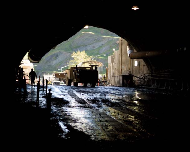
View out from the east side of the Caldecott Tunnel excavation. Photo by Karl Nielsen.
Such surprises are one of the main reasons why Neuhuber works as a tunnel geologist. “Compared to surface observations alone, we can paint a three-dimensional picture of the geology of an area when we go underground,” he says. Sloan, who knows the geology of the East Bay well, has accompanied us on the half-mile hike through the freshly excavated tunnel deep under Grizzly Peak Boulevard and part of Sibley Volcanic Regional Preserve. From her knowledge of the rocks at the surface, she would not have guessed that so much sandstone underlies this part of the East Bay Hills. But while digging the other three bores of the Caldecott (the two southern tubes were excavated in the 1930s, the third one in 1964) miners had already encountered similarly thick layers of sandstone. Neuhuber estimates the layer in the new fourth bore to be at least 90 yards thick.
-
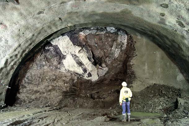
Deep under the hills, a Caltrans geologist inspects the recently exposed rock face, composed of sandstone with an intrusion of volcanic rock. Photo courtesy Courtesy Caltrans, District 4.
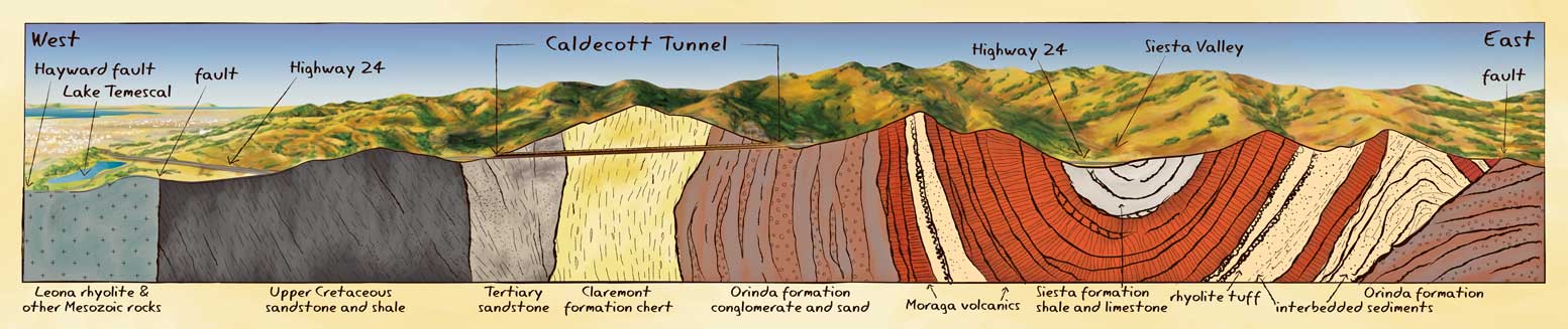
This massive sandstone layer is one more piece in the complex three-dimensional puzzle that we call the East Bay Hills, one that geologists have been mulling over for at least 150 years. But the job of a tunnel geologist is first and foremost to keep the construction workers informed about which types of rock to expect during their dig–and thereby help keep the whole operation safe. Scientific investigations and the exploration of unexpected formations clearly have to play second fiddle. But with his training in his native Austria and work on tunnel projects in the Alps, the Andes, and along the East Coast, Neuhuber finds exploring the geology from within a mountain range fascinating. That is why he and his colleagues keep samples of all rock types and formations encountered during the dig. Once the almost 3,400-foot-long tunnel is complete, these samples and the geologists’ mapping will provide a detailed cutaway of the building blocks of this part of the East Bay Hills.
While being underground helps unlock some pieces of the puzzle, it’s really only from above, way above–like from the window seat of an airplane–that you can best appreciate the impressive topography of the East Bay. Rising abruptly above the bayshore lowlands, the first line of hills forms an almost straight ridgeline between San Pablo in the north and Fremont in the south. Farther inland, several valleys and more ranges follow the same directional trend. The valleys are filled here and there with reservoirs, and much of this land is protected watershed for those reservoirs or parkland managed by the East Bay Regional Park District, gradually giving way to the broad valley carrying Interstate 680.
-
This cutaway diagram shows the complex geology of the East Bay hills, where Caltrans is digging a new fourth bore of the Caldecott Tunnel. Illustration by Brian Maebius. Click image for a larger version.
Hiking across the terrain in these parklands provides another kind of perspective–and an appreciation for the steep up-and-down topography. In fact, scientists have learned a lot about the origin of our iconic hills from just a handful of easily accessible sites, many protected within the East Bay Regional Park system, from Sibley to Briones and Las Trampas regional parks.
The first stop on our exploration of the hills’ geology is not at all park-like, however. In the road-cut near the east portal of the current Caldecott tunnels, one of the region’s most notorious traffic bottlenecks, almost vertically tilted layers of rock in various shades of gray, dark brown, and red are exposed. Before the new fourth bore opens and improved traffic flow leaves us less time to marvel at these rocks, let’s study them for the story they tell of the formation of the East Bay Hills.
-
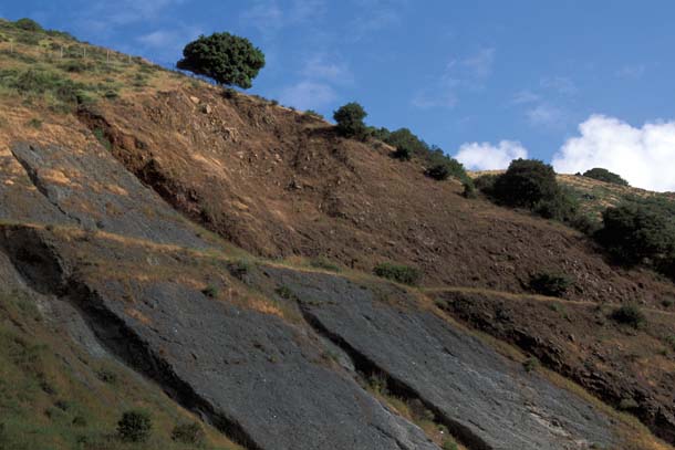
Tilted layers of dark-gray Orinda Formation conglomerates (left) and brown Moraga basalts (right) alongside Highway 24 east of the Caldecott Tunnel. Shown in dark red on the right side of diagram above, the basalts formed from lava flows during long-ago eruptions. Photo by John Karachewskl.
These layers seem to defy one of the basic principles of geology, that rocks are deposited in horizontal layers, with the older formations beneath the younger ones. The first step in unraveling the story of these rocks is to imagine the layers tilted almost 90 degrees to the west into their original, horizontal positions. The gray layers closest to the tunnel would be at the bottom, overlain first by a reddish rock formation and finally by a layer of gray-to-brown rocks.
The bottom rocks are part of the Orinda Formation, which is between 10 and 12 million years old. Geologists call these rocks “conglomerate” because they contain pebbles of all sizes, glued together by very fine-grained minerals, similar to the way cement binds sand and aggregate into concrete. The pebbles inside these rocks tell a fascinating story. They are of a rock type that we find today in San Francisco and in Marin County–to the west of us–but not elsewhere in the East Bay. Both the pebbles and the minerals they’re trapped in were carried by streams to their current resting place. But rivers flow only downhill, so geologists speculate that about 10 to 12 million years ago, the topography of our landscape was reversed: There was a highland where the valley of the Bay is now, and a lowland where the East Bay Hills are today.
The “top” layer of rocks in our story–the layers now farthest east–have a very different and more violent origin from a later chapter in the evolution of the East Bay. These are basaltic lava flows of the Moraga Formation, which erupted from several volcanoes in the region. One of them, now exposed nearby at Round Top in Sibley Volcanic Regional Preserve, was active for more than a million years, starting about 10 million years ago. Its eruptions covered the Orinda Formation with many separate lava flows, some of them several feet thick. At their base is a red zone that formed when the hot lava oxidized the iron in the underlying sediments. This gave them the distinct red color we see today at the rock outcrops along Highway 24.
If both formations were originally deposited horizontally, how did they end up almost vertical? The answer lies in the sliding of the Pacific Plate against the North American Plate, also the cause of our region’s notorious earthquakes. Although we think of today’s plate movement as almost exclusively horizontal (with the plates sliding past each other), it also has a small component of push. That started a few million years ago, when the angle at which the two plates collided changed slightly, pushing the plates together. As a result, the rocks in the collision zone were squeezed, folded, and uplifted, generating what are now the East Bay Hills. The almost vertical tilt of the Orinda and Moraga formations is one example of this process, which geologists call transpression.
-
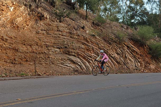
On Skyline Boulevard near Sibley Volcanic Regional Preserve, a bicyclist speeds by a bent and folded rock formation called Claremont chert. These rocks are made of the remains of single-celled marine plants and animals that died and drifted down to what was then the seafloor. Photo by Horst Rademacher.
A few remarkable rock outcrops to the west, along Skyline Boulevard in Oakland, take us farther back in time, to rock layers formed 14 to 18 million years ago. They have been twisted, folded, and bent as if they had been squeezed between the jaws of a vise. These rocks look very different from the conglomerate and volcanics east of the tunnel. Though this stretch of Skyline sits more than a thousand feet above sea level, this rock is made of the fossil remains of countless single-celled plants and animals called diatoms and foraminifera.
-
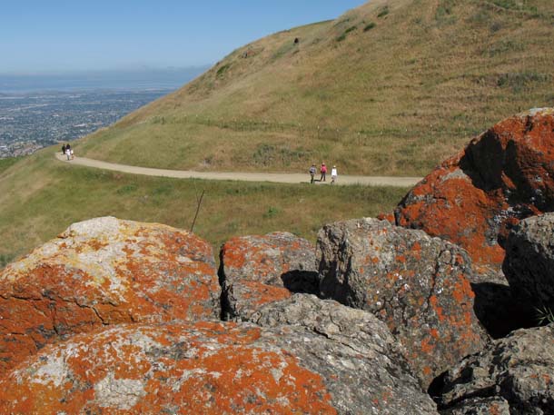
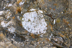
Sandstones of the Briones Formation covered with striking orange lichen, along a trail at Mission Peak Regional Park in Fremont. Photo by John Karachewskl.
These microorganisms are the basis of the marine food chain, so the rocks must have originally been deposited on the ocean floor. The layers are the chert of the Claremont Formation, prominently exposed on Claremont Avenue just below its intersection with Fish Ranch Road.
When did that long-ago sea disappear? We can find clues in another formation of rocks of marine origin, north and east of the tunnel. The exposed ridges in Briones Regional Park and in the Las Trampas Wilderness are made of strong, erosion-resistant sandstone which was laid down between 12 and 13 million years ago. It contains fossilized clams and other mollusks that once lived in shallow waters near a shoreline. This formation essentially marks the beginning of the transition from deep waters of the Claremont Formation to a time when the land now covered by the East Bay Hills had risen out of the sea. There are great exposures of this sandstone with clearly visible mollusk shell fossils at the top of Las Trampas Ridge, west of the parking lot at the end of Bollinger Canyon Road (note that collecting is prohibited on park district lands).
In another spectacular rock outcrop on Bollinger Canyon Road close to Saint Mary’s College in Moraga you can see a later stage of the evolution of the East Bay Hills. There the ripples left by the wave action in a lake or an estuary are “set in stone” in a layer that is also tilted vertically.
-
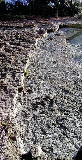
This remarkable exposure near St. Mary’s College in Moraga shows fossilized ripples left by wave action in a lake or estuary. Photo by Horst Rademacher.
From just these few easily accessible sites, we can begin to see a picture of the geologic history of the East Bay Hills: Until about 12 million years ago the area was first at the deep floor of the Pacific Ocean and later covered in shallow seas. As the sea receded the area became a coastal lowland. It was slowly filled by sediments, which rivers carried from hills in the west. Then, from about eight to 10 million years ago volcanoes erupted and covered the lowlands with thick basalt and lava flows. Under the persistent force of transpression, the lowlands began to rise roughly four million years later. They reached their current heights only about one million years ago, forming the hills as we know them today. In fact, they are still rising today by about a sixteenth of an inch per year, squeezed between the East Bay’s two major faults, Hayward in the west and Calaveras in the east. Their actual growth, however, is minimal because the erosion caused by the winter rains almost balances the gradual tectonic uplift.
This general layout of events applies not only to the section of the East Bay Hills along Highway 24; it also describes the general history of the entire range from San Pablo Bay in the north to Fremont in the south.
But as always in geology, things are not as simple as we might wish them to be. Although the area has been studied and explored by geologists for more than a hundred years, there are still a few mysteries hidden in these hills.
On the western flank of the East Bay Hills, for a stretch of more than 20 miles between Berkeley and a point south of Hayward, you can see outcrops of bluish-gray volcanic rocks that contain an unusually high amount of silica. These volcanic rocks are two types of rhyolite, called Leona and Northbrae after the Oakland and Berkeley neighborhoods where they were first discovered. The Northbrae rhyolite is exposed in several parks in the Berkeley hills, like Indian Rock and Hinkel Park.
For more than 50 years the sister rock, the Leona rhyolite, was dug out of the huge Leona Quarry at the upper end of Hegenberger Road in Oakland. The mining was profitable because the rhyolite also contains large amounts of iron and sulfur used in industry. Later the rocks were used as fill for the Port of Oakland. The huge scar on the west side of the hills above Oakland can be clearly seen from across the Bay, though the former quarry is now filled with condominiums and townhouses.
Because at first glance the two rock formations look very similar, geologists once thought they belonged to the same formation. But it turns out that they have very different origins. The Leona rhyolite is more than 150 million years old. It erupted far away and was carried to the western edge of the North American continent by the movement of the Pacific Plate–similar to driftwood washing up on an ocean beach. The Northbrae rhyolite, however, erupted locally, like the Moraga volcanics, though the Northbrae eruptions predate the Moraga formation by more than a million years.
Today no active volcanoes threaten the East Bay Hills, and we’re unlikely to find marine environments in these hills any time soon. But next time you take in the views of hills, city, and Bay from your favorite vista point, spare a moment to note the rocks at the roadside or under your hiking boots. They tell stories of a turbulent past, of the epic fight for dominance between sea and land, of tectonic upheaval and the immense geologic forces that folded up these hills and gave the East Bay the dramatic topography now protected in the string of East Bay Regional Parks and watershed lands from Fremont to the Carquinez Strait.
-
Photo courtesy Contra Costa Historical Society.
Photo courtesy Contra Costa Historical Society.
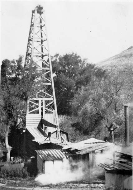
Gusher!
At the end of the 19th century, many people thought there was substantial mineral wealth in the East Bay Hills. It started in 1895 near Miner Road in Orinda, when a rancher discovered a tar-like substance on his land and had some wells drilled. All were dry until October 17, 1903, when one of them hit an oil seam. The black liquid was under so much pressure that it shot out of the well in a huge gusher. But the euphoria about the find was short-lived. The spurting oil ignited on an open-flame lamp hanging off the derrick, which went up in flames. Worse, the oil flow stopped after a few hours, robbing the rancher of his dream of quick money. A quarter-century later, the Orinda Petroleum Company was founded, drilled more than 3,000 feet down, but abandoned its attempt in 1931 after the well turned out to be dry.
Traces of naturally occurring hydrocarbons have also been found in the various tunnels crossing the hills. When the BART tunnel was dug in 1969, the miners reported tar-like patches of rock. In the Caldecott’s new fourth bore, Caltrans geologist Gerhard Neuhuber found honey-brown petroleum-soaked rocks, and even spots that looked and smelled like asphalt. These rocks are similar to the hydrocarbon-bearing layers near Brentwood in eastern Contra Costa County, where natural gas is still extracted.

-300x186.jpg)