I’m in another world from the moment I step into the East Bay Regional Park District’s Big Break Regional Shoreline. Here on the edge of the Delta in eastern Contra Costa County, birds sing and soar overhead, cottonwood leaves rustle in the breeze, and on a clear day you can see across the Delta’s vast expanse of water and low-lying islands all the way to the Sierra Nevada.
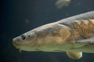
If you’re not entirely sure what the Delta is, you’re in good company. According to a recent poll by the Southern California Water Committee, an education and advocacy nonprofit, nearly 80 percent of Californians are unfamiliar with this region and its importance. Moreover, even a short answer is a mouthful. The 1,150-square-mile Sacramento–San Joaquin Delta is the largest estuary on the west coast of the Americas, providing critical habitat for wildlife such as chinook salmon, ospreys, and river otters. The Delta drains nearly half of California, funneling rain and snowmelt from the Sierra Nevada across the Central Valley and out into San Francisco Bay. It also helps supply water for 25 million people (two-thirds of the state’s population) as well as for much of the state’s agriculture.
This vital part of California remains surprisingly little-known to many people in the Bay Area, perhaps because most of the Delta’s dry land is privately held and much of the region is accessible only by boat. But Big Break Regional Shoreline offers a superb public access point along the Delta’s western edge, and it’s now home to the park district’s first completely new visitor center site in nearly 40 years.
The Delta is central to the state in just about every way imaginable. “It’s a meld of the Bay Area and the Central Valley,” explains East Bay Regional Park District naturalist Mike Moran, whose fascination with the Delta began 18 years ago when he was a graduate student in wildland resource science at UC Berkeley. “Geography, climate, politics and, of course, water all come together here.”
Big Break sits on the San Joaquin River just before it joins the Sacramento River at the neck of the Delta. This region was originally a huge tidal marsh with more than 1,000 miles of tidal channels that wound their way around ever-shifting islands of sediment. But beginning about 150 years ago, settlers built levees to exclude water so they could farm the rich peat soil and replaced most of the zigzagging tidal channels with an irregular grid of diked canals. The Delta now has nearly 60 man-made islands, most of which are below sea level due to compaction of the peat soils (subsidence), totaling about 550,000 acres.


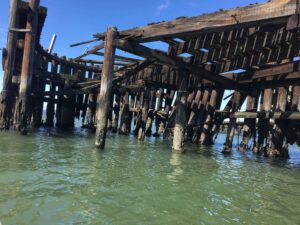
“Big Break is a microcosm of the Delta,” Moran says. From where we’re standing here in the park, we can see water, wetlands, and riparian willow thickets alive with fish, birds, and mammals. But we can also see a corporation yard filled with heavy equipment on one edge of the park, a row of houses crowding up against another edge, and a wind farm across the water. And what’s now water and marsh was once an asparagus farm. A levee break in 1928 let the San Joaquin River flood the subsided land and gave Big Break its name.
Though it seems more natural 80 years after the flood, Big Break today is nothing like it was before the Delta’s conversion. Most of the 1,650-acre park is open water about five feet deep instead of the shallow tidal marsh that formerly dominated this part of the Delta. But the park’s open water is fringed by marsh, and even this small remnant is important because only some three percent of the Delta’s original tidal wetlands remain. “This is a rare piece of tidal wetland,” says Robin Grossinger of the San Francisco Estuary Institute, who coauthored a recent study using historical records to reconstruct a picture of the Delta before European settlement. Big Break is also in the part of the Delta where salt water from the Bay mixes with fresh water from the mountains, creating even more diversity of habitats and wildlife.
This fringe of marsh at Big Break is a restoration project in progress. “We broadened a deep slough, opening up a tidal wetland,” Moran says. “It’s natural reclamation with no planting.” He points out water-loving natives, from tules and cattails to willows and cottonwoods. Nonnative species, which abound in the Delta, are moving in too, offering the opportunity to experiment with ways of controlling them.
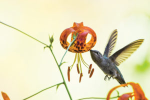
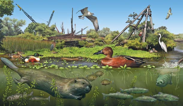
Despite its wholesale transformation, the Delta is habitat for more than 500 species of wildlife, including 20 listed as endangered or threatened by either the state or federal agencies. The San Joaquin kit fox lives in the Delta, and so does the Delta smelt, a three-inch silver fish found nowhere else. Big Break attracts beavers, muskrats, and otters. “It’s critter heaven,” Moran says, adding that “the birding is fantastic.” The park is home to about 70 species of birds, including bald eagles and green herons. In just a few minutes, we see a dozen birds including, to my delight, a green heron. This is my first California sighting of one of these beauties, whose rich chestnut neck sets off its iridescent green-black feathers. There’s also an osprey nest on a construction crane in the corporation yard next to the park.
Soon, Big Break’s native species may have even more suitable habitat. Nearly 1,200 acres around Dutch Slough, just east of the park, are slated to be restored from rangeland for dairy cows to tidal wetlands. The area is one of the few parts of the Delta that has not subsided much and so still has topographic diversity. “It’s hugely exciting,” Moran says. “They’re going to blow out levees and let Marsh Creek flow naturally.” Marsh Creek is a major Contra Costa County watershed that drains into Big Break, dividing the wetlands here from the future tidal marsh around Dutch Slough, so restoration around the slough will be a boon to Big Break–and to the chinook salmon that run up Marsh Creek. This kind of connection is key to boosting wild-life habitat in the Delta. “One of the great challenges of eco-logical restoration is how to make functional links between restored areas,” Grossinger says. “You want to avoid pockets of restoration.”

For the people of Oakley, the park and new visitor center at Big Break have been a long time coming. “I’ve waited 25 years for this,” says Loni Cronin, whose yard backs up to Big Break. The park has its roots in a plan for a local facility on the water to provide education and access to the Delta, where most of the land along the shore is privately owned. “It took years to raise the money, but we really felt the Delta’s story needed to be told,” says park district General Manager Robert Doyle. Indeed, the project required about $10 million, from acquisition of the land to building and opening the visitor center.
“Before East Bay parks got the property, Big Break was completely closed off,” says Roni Gehlke, executive director of the Delta Science Center, an Oakley-based nonprofit that helped spearhead the plan and now holds periodic education events at various venues. “Now kids can come find out about the plants and animals living right down the street from their houses.”

A September visitor center open house is full of kids doing just that. Nev Thompson, who’s almost five years old, and her big sister Nari, who’s six, just made miniature tule boats and are floating them in a bucket of Delta water. Their boats forgotten, the girls start scooping water into hand-held magnifiers in search of tiny aquatic creatures. Nari shows me her catch: “Look! I found a sea snail!” Unmagnified, the object of her excitement is the size of a grain of rice. The magnifier reveals a tiny snail with a rich brown shell shaped in an elegant, long spiral, part of the rich stew of small creatures that underpin the Delta’s food web. The Thompsons, who live in San Ramon, have been following the visitor center’s construction. “My kids love nature and wanted to come to the opening,” says Ed Thompson, Nev and Nari’s dad.
A certified green building, the visitor center has ample room for educational displays that are expected to be in place within a year or two and, perhaps best of all, a lab for hands-on science education. “This is a dream come true,” Oakley mayor Kevin Romick tells me at the open house. “It’s a wonderful opportunity for students here to get in touch with the Delta, which will help with the message that we live in a vital waterway that’s important to protect.”
Several families who live nearby are here to learn about the owls of Big Break. The park has resident barn and great horned owls, as well as habitat suitable for burrowing owls, an at-risk species that lives in nearby parts of the Delta. All ages from youngsters to grandparents pack the science lab, where East Bay parks naturalist Eddie Willis soon has them acting like owls. Explaining that owls’ round faces help focus the sounds of prey, he demonstrates by cupping his hands around his face as his audience follows along.
The visitor center lab will be a boon to local teachers as well as the Delta Science Center, which offers a fifth-grade program on the ecology and species of the Delta that is aligned with state formal education standards. “We’ve been bringing the Delta to the classroom but now we’ll be able to bring kids out to the Delta,” says Executive Director Gehlke. “They’ll be able to say, ‘Oh, I know where and what the Delta is.’” Middle school teacher Sheri Schermerz, who lives in Oakley, is jazzed about the high-powered microscope that reveals the many tiny creatures living in the Delta’s water. “My students will love this,” she says. “The lab will give them hands-on, real-life experience.”
Larger creatures–stuffed birds as well as carnivore pelts and skulls–are on display in the meeting room at the other end of the visitor center. Big Break naturalist Mike Moran asks us how we know what kinds of animals live in Big Break when we hardly ever see them. Shouted-out guesses include by their tracks and by the types of habitats in the park. “Those are good ideas, but poop–or scat–is best,” Moran says. “That’s what scientists use.” Passing out samples in ziplock bags, he shows us that scat from bobcats and the rest of the cat family has clean edges. In contrast, scat from foxes and the rest of the dog family tapers to a point. Otter scat is so full of crawdad shells that it’s orange when fresh. Then Moran’s nine-year-old son, Duncan, brings us an exciting find: scat fresh from the park! The tapered ends say dog family, but is it from a small pet dog or a fox? Breaking the scat open, Moran finds bits and pieces that tell him it’s probably fox scat. We all peer in for a closer look.


Moran also uses Big Break to introduce classroom teachers to the ecological wonders of the Delta. “Our big thing is to get them into the field,” he says. Starting at Big Break, teachers explore the Delta on foot and in kayaks as part of the four-day Sacramento–San Joaquin Delta Institute, which is aligned with middle- and high-school state standards. “Our goal is to teach teachers so they can inspire their students to learn about the importance of the Delta in their lives,” explains John Promani, part of the education team at the California Institute for Biodiversity, which helped establish the Delta program.
Besides immersing themselves in the Delta, teachers take part in hands-on activities they can share with their students. One of the most popular is a photo scavenger hunt to seek out places that illustrate Delta-related issues the teachers have learned about in the program. “Teachers go out and photo-document things like subsidence, water diversions, and migrating waterfowl,” Moran says. “Seeing what these issues look like on-site reinforces what they’ve learned.” Besides incorporating these photos into their classroom lessons, teachers can bring their students to Big Break to hold their own photo scavenger hunts.
Teachers also learn how to augment their lessons with multimedia explorations of the Delta developed by Quest, kqed’s science journalism and education program. These explorations include an interactive map of the entire Delta and a virtual hike at Big Break. “We’re bringing information to our community in a creative, engaging way,” says Andrea Swensrud, kqed’s science education project supervisor. Upcoming projects include an interactive e-book that uses Big Break to tell the story of the Delta.
The open house is capped with a short walk from the visitor center down to the water. East Bay Parks naturalist Kevin Damstra takes us past the restored tidal marsh Moran showed me and onto a small Delta island with a 100-foot-long observation pier and a cove for launching kayaks. The island also has a 3-d map of the Delta embedded in the walkway. Representing some 700,000 acres, the 1,200-square-foot map is detailed enough for Oakley residents to find where they live. The map is built on a slight slope and has shallow waterways that, like the real Delta, drain toward the Bay when it rains. Around the map are three paths representing the Delta’s major waterways: The path from the visitor center to the map is the San Joaquin River, the path from the map to the kayak-launching cove is the Carquinez Strait, and the path to the pier is the Sacramento River. Standing on the pier, Damstra recalls an early morning when he saw seven river otters jumping off a rusted dredge into the water.
“The great thing about this park is that it’s always open,” says the Delta Science Center’s Gehlke, who lives a short walk away. “You can enjoy it any time.” Actually, it’s closed dusk to dawn and parking doesn’t open till 8 a.m., but the park is accessible pretty much whenever most of us would care to visit. Me? I’ll be back soon to watch otters playing as the sun rises over the shining blue waters in this amazing–and now finally accessible–part of the Delta.