.jpg)
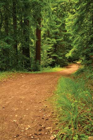
Purisima Creek Preserve
The shaded understory at uncrowded Purisima Creek Redwoods Preserve on the Peninsula is a delicious place to ramble in hot weather, especially when berries start to appear in early summer. Mature second-growth redwoods, mingled in places with madrone and Douglas fir, shelter the gently flowing stream and a lush understory of shrubs and ferns. The shady trail along the creek occasionally crosses tributaries trickling down the steep hillside.

- Photo by Misha Logvinov.
From the preserve’s west entrance, Purisima Creek Trail is a narrow hard dirt road (closed to cars) following Purisima Creek for 2.3 miles before climbing steeply another 1.7 miles to Skyline Boulevard. The first half mile is nearly level, with a well-graded fine gravel surface. Then wheelchair users may require assistance on a brief medium-steep stretch with uneven surfacing. This is followed by another 1.6 miles of moderate to easy going, until the trail leaves Purisima Creek and starts its climb out of the canyon. If you push on, you’ll find this stretch good and steep, with some transverse slope, though well-graded. To keep my power chair from overheating, my husband Dan got behind and pushed. (He never goes to the gym, just hangs out with me.)
The east trailhead—actually the southernmost of two entrances on Skyline (Highway 35), 6.5 miles south of Highway 92)—is not a good way to get a wheelchair to Purisima Creek, but it does have a pleasant accessible picnic area and the Redwood Trail, a 0.2-mile all-access nature trail that runs along the hillside. The west entrance, which provides the best hiking opportunity, is a longer drive from east of the ridge: One mile south of Half Moon Bay, go east on Higgins Purisima Road for a little over three miles. Both entrances have a picnic area, water, accessible parking, and toilets. No entry fee; only service dogs permitted. Visit www.openspace.org or call (650)691-1200 for information.
Point Pinole Regional Shoreline
Many bayshore parks have wheelchair access, and some can be reached by public transit, but Point Pinole Regional Shoreline north of Richmond stands out for the variety of habitats along its maze of trails. The largest park on the northeast Bay shore, it has bluffs with fine views across the water in three directions, tree-studded meadows, beaches, and dense groves of eucalyptus planted in the 1920s by the explosives companies that operated here until 1960.
The exotic trees have certainly altered the peninsula’s environment, but native natural features remain, including the coastal bluffs and two salt marshes. There are at least five miles of accessible trails, mostly well-graded gravel usable in all weather.
Point Pinole Road (closed to automobile traffic) is the main route, 1.5 smoothly paved miles out to the fishing pier. It starts by climbing to a railway overpass; assistance may be required there and on a couple of other moderate slopes, but most of the trail is nearly level. Benches are available all along the way. The fishing pier has windbreaks designed to accommodate wheelchairs.
A map available at the entrance shows the many trails that crisscross the park. Some are challenging due to loose surfaces and steep grades, but several trails on the east side of the park are nearly level well-graded gravel. Cook’s Point, Marsh, and Owl Alley trails make a nice loop to a lovely spot on the shore. A few benches and picnic tables are provided along these less-traveled routes.
An hourly shuttle runs Thursday through Monday from the main entrance to the pier. The van is inaccessible to wheelchairs, but you’re allowed to follow it in your own vehicle by prior arrangement; call (510)237-6896. Accessible toilets are at the park entrance, both picnic areas, and the foot of the pier.
AC Transit #71 bus serves the park from Richmond BART. Driving, take I-80 to Hilltop Mall exit, go left on Hilltop Drive to Richmond Parkway, go left again for one mile to Giant Highway, then 0.5 mile to Point Pinole on the left; $5 parking fee.
Joseph D. Grant County Park
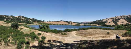
- Photo by Dan Hill.
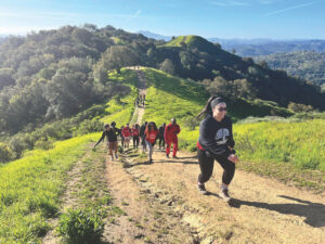
The largest county park in Santa Clara, Joseph D. Grant, covers 9,553 acres on the slopes of Mount Hamilton east of San Jose. On a mild weekday in July, we hiked for hours without meeting any people at all, on trails that are challenging but entirely usable with assistance and/or a good power chair.
By the entry kiosk a dozen vultures loitered on fence posts, waiting for an updraft of sun-warmed air. Two or three at a time, they flapped ponderously as if boarding a bus and glided up into the bright sky.
From the ranger station, a half-mile of paved and level whole-access trail winds through the main picnic area, affording views of San Felipe Creek. But the prettiest easy walk here is the part of Yerba Buena Trail that skirts Grant Lake (park on the left just past the main park entrance). This fairly smooth 0.3-mile gravel path has views of the lake and its resident waterfowl, as well as the swallows, red-winged blackbirds, dragonflies, and butterflies flying around it. Unfortunately, the picnic area shown on the park map is gone, and there are no benches along the first part of the trail.
A fairly ambitious longer hike is the three-mile valley loop south on Lower Hotel Trail and then back via Corral and San Felipe trails. It is impeded in places by minor erosion and shallow drainage trenches, with some steep spots and places where large gravel makes a rough ride.
The payoff is ancient oak trees that bend writhing limbs alive with acorn woodpeckers over the trail. Golden grasses shimmer on the hillsides, while quail, ground squirrels, and small rabbits retreat into the coyote brush. East across a green-gray meadow rises the white dome of Lick Observatory atop Mount Hamilton. Though unimpressive close up compared to Diablo and Tamalpais, at 4,209 feet it’s the tallest of the three, by 360 feet.
If you like solitude, this little-used park is an inviting destination for overnights as well as day trips, since the campground has accessible toilets and even roll-in showers. The eight-mile drive to the park on Mount Hamilton Road (aka Highway 130) is narrow, with lots of hairpin curves. Take Alum Rock Road east from Highway 101 and turn right on Highway 130. The $5 parking fee will be waived if you have a disabled parking placard; camping fees are half-price.
Rush Ranch Open Space
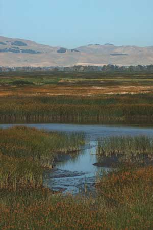
- Photo by John Karachewski.
Suisun Marsh in Solano County contains about one fifth of the remaining 50 square miles of undiked tidal marsh in the Bay-Delta estuary. One of the best places to experience the marsh is at Rush Ranch Open Space south of Fairfield, owned and managed by the Solano Land Trust. The California clapper rail and the Suisun song sparrow are two of the many rare and endangered species that survive here in the mix of freshwater and brackish habitats.
The good news for a wheelchair user is that it’s flat out here. The ranch sits on a shallow rise adjacent to Suisun Marsh, and most of its trails head out over the lowlands. There’s a pleasant picnic area in a eucalyptus grove, an accessible toilet, and a small but accessible visitor center.
The bad news is, even the hills get really muddy when it rains, and what with grazing cattle, in many places that mud dries into hoofprint-pocked hummocks, tortuous if not impassable in a wheelchair.
Nevertheless, there’s much to enjoy here. The Marsh Trail’s first quarter mile descends easily to the marsh. Across the wetlands, swallows swoop and dive and herons fly low over the lush marsh vegetation. A couple of tule structures have been built here and we stop to watch a group of schoolchildren being instructed on Patwin Indian food preparation by volunteer docents. Beyond this point, the levee section of the Marsh Trail is not accessible due to flood damage.
One can go farther on the nearly level South Pasture Trail, a 2.4-mile loop with a few rough patches. Both trails have markers and printed guides with information for visitors.
Except near the ranch buildings, all the trails here have some rough going. An alternative is to take one of the free horse-drawn carriage rides for mobility-impaired visitors provided several times a month by Access Adventures. These carriages are equipped with wheelchair lifts! For more information, call (707)426-3990.
To get there, take Highway 80 to Highway 12, go four miles east to Grizzly Island Road, then 2.5 miles south. No entry fee. For more information, go to www.rushranch.org.
Point Reyes National Seashore: Coastal Camping
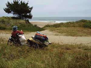
- Photo by Dan Hill.
Over my two-plus decades of using a wheelchair I’ve sorely missed the great feeling of hitting the trail with everything I need on my back. So when, on a day hike, we found a wheelchair-accessible vault toilet at Point Reyes’s Coast Campground, it inspired my husband Dan and me to plan an overnight expedition there. Those wide doors and grab bars three miles from the road might seem odd to some people, but for us they made this overnight adventure possible.
We set out on a sunny weekday morning in June. This isn’t exactly backpacking: Dan’s bicycle cart, with bulky army-surplus cots lashed onto it, is attached behind my power wheelchair, and two canvas bags hang on the chair’s sides. Harnessed up, I feel more like a lumber truck headed for a construction site than the leave-only-footprints go-light fanatic I am.
But it’s fun to play the faithful pack-pony, picking my way around occasional ruts and soft spots on the gravel track that drops gently over grassy hillsides among mixed woods and brush, skirts a creek, and climbs slightly to reach bluffs overlooking the Pacific. At the junction with Limantour Beach Trail, where surf rumbles only a few hundred feet away, a 15-foot sandy stretch forces me to detour on hummocky grass. But if anything, the extra weight improves the chair’s traction. The ease with which it handles this rough terrain is encouraging, if anticlimactic.
The morning is glorious here, but a gray curtain hangs just offshore. Carl Sandburg’s fog came in on little cat feet. This fog is crouching to spring, and as we make our way south over the bluffs its paws reach over us, dashing our hopes of constellation-viewing tonight.
Just before Coast Camp the trail dips steeply to cross a culverted stream, and when the chair makes easy work of this too, we’re home free. There’s the concrete and sheet-metal privy, and beyond it our reserved campsite. Dan unhooks the cart and removes my panniers, and though it’s been 24 years since I slid a pack off my shoulders, I feel something akin to that lightness when I can move my chair freely again.
The campground lies in two shallow ravines, among scattered thickets of coyote brush in deep dry grass. We’ve got a table, a barbecue, and a varmint-proof cabinet on a small shelf in the hillside, with another shelf below for our cots. Getting around this split-level campsite would be exhausting in a manual chair—as would visiting the privy, 150 feet away through deep grass, with a final steep stretch. Apparently no one expected a wheelchair to actually make it here.
- Photo by Ian Tait.
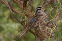
Unfortunately, we can’t see the ocean from the camp, and the trail to the beach is inaccessible in a wheelchair, as is the Coast Trail south of the campground. By afternoon, wet ocean fog blots out the ridgetops and trails in skeins across nearby hillsides. That doesn’t bother the white-crowned sparrows, who trill at the top of their tiny lungs, evidently surfing a sea of testosterone. As evening comes on we’re visited by four exotic deer, each a different color, like Easter eggs.
No fires are allowed here, but we prepare a hearty soup dinner on Dan’s backpacking stove, and enjoy it by candle light. Tonight I will sleep miles from the nearest car for the first time in many years.
And I do sleep, quite well. But once, in the night, I open my eyes and find a wide window has opened in the fog. There is the Big Bear, and part of Draco curved near it. For this, I reach over to wake Dan. Hard to tell in the dark how impressed he is, but at least he’ll believe me in the morning. I watch as the stars are veiled and then appear again. Much closer, a white-crowned sparrow tries a groggy trill. “Go back to sleep, you silly bird,” I think. It does, and so do I.