.jpg)

-
On June 2, officials and members of the public reviewed multiple concepts for the new Gateway Park. Photo by Dan Rademacher.
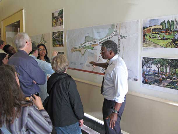
On June 2, about 80 people gathered in a CalTrans auditorium in downtown Oakland to hear, and discuss, the plan for a major new shoreline park at the eastern foot of the Bay Bridge, where the new bike and pedestrian lane will touch down.
If you’re having trouble picturing what sort of park one might have there, you’re not alone. At present, it’s essentially a no-man’s-land: More than a quarter million cars pass by every day, but the site is difficult access by any means. And the land is a patchwork of ownership and uses, from an open point that juts into the Bay (granted to the East Bay Regional Park District by the Army) to CalTrans maintenance yards to sewage treatment to areas slated for dense development, perhaps even a major hotel complex.
Despite the complexity, the nine agencies that own land here have been gathering public input on how to create what could be “one of the great waterfront destinations in the world,” in the words of Will Travis, executive director of the Bay Conservation and Development Commission.
But it will take some doing. “Waterfront advocates, city builders, urban planners, and government bureaucrats,” says Travis, “we all must dedicate ourselves to creating something more than a park at the foot of a bridge.”
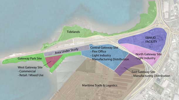
- Map showing ownership of the future site of Gateway Park. Map from report by Perkins+Will (full report here).
Consultants hired by the nine-agency Gateway Park Working Group presented three conceptual plans, products of a previous public meeting held in February 2010. The plans offer a gradation from mostly habitat and passive recreation to more active development with major trail connections to a fully developed urban destination with boardwalks and even a landmark ride modeled on the London Eye (a 442-foot-tall Ferris wheel built in 1999).
Perhaps what’s most remarkable about the park is just how much space there is to work with–and in what odd arrangements. Sarah Kuehl of PWP Landscape, who presented the design concepts, describes it as “a place made of ribbons,” and the planning area includes long, sinuous (and sometimes discontinuous) spaces under the Oakland Maze and along Maritime Boulevard in the port.
Of the three concept proposals, the one dubbed “Relax and Restore” has the least development, with a focus on habitat restoration and such activities as birding and picnicking. The second concept, called “Getting There,” would prioritize multiple trail and transit access connections, with a dramatic elevated bikeway along Maritime, a ferry landing, a kayak launch as part of the Bay Water Trail, and potentially contentious Bayshore trail routes on the north side of the bridge along the Emeryville Crescent, which is designated as habitat within Eastshore State Park. The third and most ambitious concept, “Great Destinations,” seeks to transform the area into a major cultural draw with restaurants, a museum, artful parts of the old Bay Bridge as massive public art, multiple ball courts and demonstration gardens under the freeways, and even a boardwalk and Ferris wheel at the far western end, on the water.
Steve Heminger, director of the Metropolitan Transportation Commission, sounded one note of caution early in the public meeting: “I’m not going to ask you to focus on dollars and cents yet, but we will have to eventually. I only have one design precondition: that it have no self-anchored suspension span. Other than that, the sky’s the limit. We need to dream big.”
The concept presentations were followed by ten breakout sessions for small group discussions among the event attendees. Park planners will next report on their progress based on that feedback in fall 2010.
Find out more about the project and the process at baybridgegatewaypark.org.
.jpg)
