.jpg)
“Watch out for the poison oak,” warns Carol Prentice as we clamber down a steep slope above the Lower Crystal Springs Reservoir near Interstate 280. The freeway noise behind us begins to ebb as we descend into the valley bounded on the west side by the dark slopes of the northern reach of the Santa Cruz Mountains. Prentice stops for a moment and we look down the slope. “I have had two distinct reactions from the people I’ve shown the actual fault line to,” she says. “They’re either disappointed and say: ‘What! This is it?’ Or they are utterly impressed to be standing on the boundary between two of the giant plates of the earth’s outer layer.” I get the feeling that my guide, a research seismologist with the United States Geological Survey (USGS) in Menlo Park, wants to test my reaction, too. She has brought me into the valley west of Hillsborough on land owned by the San Francisco Public Utility Commission to show me one of the few traces left of the biggest natural disaster ever known to strike the Bay Area, the Great San Francisco Earthquake of 1906.
Finding Fault: 1906 Revisited
I had read the famous “Lawson Report,” a meticulous compilation of all but the smallest effects of the earthquake. The report, written by some of the most distinguished geologists in America at that time, was published two years after the quake and contained, among others, several pictures of fence lines driven out of alignment by the quake. These fences cut across what the authors then called the “San Andreas Rift.” The shifting of the earth during the quake had offset the fence lines by eight feet or more. On this bright winter day, nearly 100 years after the magnitude 7.8 temblor struck Northern California, Prentice wants to show me one of the last of these original fences still standing.
One of the grainy black-and-white pictures in the Lawson Report shows a fence stretching downslope through mostly open grassland. To its left is a row of newly planted saplings, not much higher than the fence itself. About halfway down the hill, the continuous slope flattens out a little bit, only to drop again a few feet beyond that point. It is on this “bench” in the slope where the fence shows a remarkable bend. The offset in the fence appears to be about nine feet.
The slope we are hiking down today in no way resembles the open grassland in the century-old picture. The hillside now is covered with bushes and several species of oak trees, which block the view. The tree saplings seen in the picture have grown into mature conifers, lined up in a row to our left all the way downslope. The trees stand beyond a rickety fence, with many of its posts leaning every which way, but most of its barbed wire still attached. On our way down the hill Prentice stops where the slope flattens out a bit. I look around and notice a few shallow depressions in the ground where water can accumulate during a rainstorm. I can also see that the fence line to my left is bent a bit. My guide looks at me and pulls out a copy of the old photograph from the Lawson Report. “Is this it?” I ask in disbelief, and she nods. We are standing right on the San Andreas Fault, without a doubt one of the most famous earthquake faults in the world, on a spot that shook so violently in the early morning hours on April 18 a century ago, that the earth’s movement would have knocked down any person standing here. But today had I been a casual hiker without a guide, I would most certainly have missed the fault line, so subtle is its current expression.

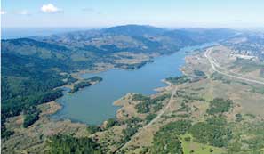
- Upper Crystal Springs Reservoir (foreground), west of SanMateo, fills part of the linear valley produced by the San AndreasFault. Highway 280 and Canada Road to the east of the reservoir are onthe North American Plate; the northernmost ridge of the Santa CruzMountains on the left is riding northwest on the Pacific Plate. Photoby Saul Chaikin.
The scientists who fanned out far beyond the ruined city of San Francisco 100 years ago, trying to compile as much geologic evidence about the earthquake as they could, saw quite a different picture. Immediately after the earthquake, one did not need a trained eye to spot its traces: Offset fences, broken roads and railtracks, and mile after mile of cracks in the ground showed the line where the earth had ruptured so violently. Led by Andrew Lawson, a professor of geology at UC Berkeley, the scientists found these obvious traces along an almost straight line stretching 270 miles from Shelter Cove in Humboldt County in the north to the mission town of San Juan Bautista in the south. John Casper Brenner, then head of the Department of Geology and Mining at Stanford, described the trace of the fault south of San Francisco “as marked by a belt of upturned earth resembling a gigantic mole-track.”
But in the same way as the hillside we visited has changed during the last hundred years, almost all obvious traces of the earthquake have vanished. Cracks in the earth have been filled; burrowing animals have turned the soil over many times; fences, roads, and rail lines have been repaired; and some stretches of the fault line have been covered by houses or buried under the concrete of freeways and the asphalt of parking lots. The fault, it seems, has all but disappeared. All that’s left for the layperson to see are a few “earthquake trails” like the one at Point Reyes National Seashore near Olema or at Los Trancos Open Space Reserve above Los Altos. In these parks the public has easy access to the fault. Signs and placards explain the tectonic situation. In some places, old fence lines and their offsets have been carefully reconstructed; however, the fence we saw near the Lower Crystal Springs Reservoir is the only one remaining that has neither collapsed nor been repaired during the intervening years.
Perhaps the best way to see the actual fault line today is to study an overview image of the greater Bay Area. On it you can make out a straight line running first from Tomales Bay to Stinson Beach and then—having vanished in the ocean just west of the Golden Gate—reappearing again south of the city at Mussel Rock, then running through Daly City into the long valley of San Andreas Lake and the Crystal Springs Reservoirs. Without the aid of GPS technology, Lawson and his coworkers marked exactly the same line in their detailed maps of the aftermath of the big earthquake. What differs between the GPS generated images and the geologists’ chart is not only the mapping technology. In the century since the 1906 earthquake, our understanding of the forces that shape the earth and occasionally rattle its surface have changed drastically.
For Lawson and the geologists of his time, the earth’s surface was as solid, rigid and immobile as, well, a giant piece of rock. Earthquakes and volcanoes were regarded as local or, at best, regional phenomena. Even in academic circles the experts had widely different—by today’s standards even outlandish—views about the causes and origins of earthquakes. For instance, during a meeting at the California Academy of Sciences in April 1870, the minutes noted, “a lively discussion took place in reference to Dr. Henry Gibbons’s theory of earthquakes. Gibbons argued that built-up steam was the cause, while others thought electricity was to blame.”
The Restless Earth: Introducing Plate Tectonics
If people had drawn connections between volcanoes of the Cascades Range in Oregon and Washington, earthquakes in the Aleutians, and the temblors in Northern California, they would have been called charlatans. That is what happened to the German meteorologist Alfred Wegener, who, in 1912, was the first to publish a hypothesis of continents drifting on the earth’s surface. He was ridiculed by the earth sciences establishment and led the rest of his unfortunately short life as a scientific outcast. His ideas about horizontal movements of whole continents and ocean basins were relegated to the realms of science fiction.
It was not until the early 1960s that marine geologists found—first in the Atlantic, later in other ocean basins—more and more indisputable evidence that Wegener’s basic concept was correct. Today, no modern textbook on earth science is published without an explanation of plate tectonics, the concept that nothing on the earth’s surface is really fixed and that everything is mobile. What a century ago was described as a “rift zone” of unknown origin is today a fault line separating two of the giant plates of the earth’s upper layer. The San Andreas Fault is the demarcation line between the Pacific Plate and the North American Plate.
Like their dozen or so siblings that make up the restless outer layer of the earth, these two plates float like giant pontoons on the viscous rocks of the earth’s mantle. The mantle stretches from a depth of approximately 20 miles down to the boundary with the earth’s core at 1,800 miles. Because of the enormous heat stored in the interior of the earth, the mantle is frequently described as a deep magma ocean of molten rock. However, while earth scientists have found some clear evidence for localized melting, the mantle as a whole is mostly not molten at all. Its rocks, in fact, have the viscosity of glass, commonly thought of as rigid and brittle. But glass does flow: After a hundred years or more, a windowpane will be thinner on the top and thicker at the bottom. On a geologic scale, in which time is measured in millions of years, such extremely slow flow rates add up to form convection currents in the mantle, similar to the ones you can see in a pot of soup heated on a stove. The much cooler and less dense plates of the earth’s surface float on these currents of hot viscous rock and are transported horizontally.
Earth scientists still don’t completely understand the actual forces that drive plate movement. Some think the currents carry the plates above them along; others say that the plates are pulled by their own weight, as they sink downward into the mantle in subduction zones. Whatever the driving force, the plates with their jagged boundaries and corners ram into each other or push each other out of the way. Such violent plate interactions have played a major role in the geologic history of the San Francisco Bay Area.
The story began 140 million years ago in the Early Cretaceous epoch. The Mid-Atlantic ridge had just opened into a “spreading center,” which started pushing the once-connected plates of Europe and North America farther and farther away from each other and driving North America westward. Another spreading center, similar to that in the Atlantic, existed in the Pacific Ocean far to the southwest of what is now the west coast of North America. California, as we know it today, did not exist then. It was actually part of the deep ocean. At this spreading center in the Pacific, molten rock oozed out of the mantle. As a consequence, what is now known as the Pacific Plate moved toward the northwest. Between it and North America, there was another plate, dubbed “Farallon.” It moved in the opposite direction to the Pacific Plate, toward the southeast on a collision course with westward drifting North America.
From Subduction to Strike-Slip
Where an oceanic plate such as the Farallon collides with a massive continental plate, one plate must give way, because the driving forces in the earth’s mantle continue to push and tug from underneath, no matter how big the wreck at the surface. As in most tectonic collision zones where a continental and an oceanic plate ram into each other, the latter is forced underneath the former. Over the course of some 100 million years, this process, called subduction, consumed most of the Farallon Plate as it was driven under North America and back into the earth’s mantle. Its remnants—the Juan de Fuca Plate to the north and the Cocos Plate to the south—continue to be subducted under the North American plate.
For the diving plate, subduction is a rather traumatic process. The deeper it sinks into the mantle, the more it melts. In addition, as it passes under the sharp leading edge of the massive and therefore rather stable continental plate, pieces of the top layer of rocks are skimmed off the subducting plate, much as a craftsman shaves off the surface of a rough piece of lumber with a plane. In the case of the Farallon Plate, the shaved-off rocks began to accumulate at the leading edge of the continent and eventually formed a large component of the coast ranges of Central California. Elements of these shaved-off deep sea sediments and volcanics, known collectively as the Franciscan Complex, are exposed in many places around the Bay Area, including in the Marin Headlands just north of the Golden Gate.
However, about 29 million years ago, the nature of the plate collision along the western edge of North America began to change. By then, almost the entire Farallon Plate had been consumed under the North American continent, which slowly but surely began to override the Pacific spreading center, encountering a new tectonic partner—the Pacific Plate. With that encounter, the nature of the plate boundary underwent a fundamental shift. The subduction caused by the almost head-on collision between the North American and Farallon plates stopped. As the North American Plate started to override the Pacific spreading center, the northwestward motion of the Pacific Plate began to take over the interaction between the two. Instead of slamming into each other, the two plates slid along past each other resulting in what geologists call “strike-slip” motion. This type of interaction remains the strongest tectonic driving force in the Bay Area today.
Seen from the vantage point of space, the sliding occurs in a north-northwesterly direction, which is called the “strike” of the San Andreas Fault. This direction determines the layout of most of coastal Northern California’s ridges and valleys. The slipping and sliding of rocks along the San Andreas Fault, however, is not a smooth and gentle process. Indeed, the Pacific Plate scrapes and grinds against the North American continent, sometimes grabbing pieces, ripping them off, and carrying them along. The Point Reyes peninsula has been carried northward by this motion for more than 200 miles and as the process goes on, 10 million years or so from now, Los Angeles—which sits on the Pacific Plate—might indeed become a suburb of San Francisco.
Neither Lawson nor any of his colleagues knew about this movement when they investigated the great earthquake of 1906. Nevertheless, their report was so thorough and the scientific conclusions presented so far-reaching that their work is regarded as the birth of modern seismology in the United States. Their observations that earthquakes are a repetitive feature in Northern California, that the San Andreas Fault—or “Rift” as they called it—is a continuous feature running virtually the length of the state, and that the two flanks of the fault move horizontally rather than vertically, were new to science at that time.
One of Lawson’s collaborators grasped the essence of the process when he analyzed the results of land surveys on both sides of the fault conducted before and after the quake. While looking at the data, Henry Fielding Reid, a professor of geology at Johns Hopkins University, concluded that the rocks along the San Andreas behave somewhat like an elastic rubber band. He theorized that somes—to him still unknown—forces within the earth “load” the fault mechanically, in a manner similar to the stretching of a rubber band. Once the force has reached a threshold, the rubber band snaps. So do the rocks along the fault: Once the threshold is reached, they give way in an earthquake and rebound several feet within a few seconds, thereby releasing the load, or strain, that had accumulated within them for dozens or even hundreds of years.
Reid’s “elastic rebound theory” is as valid today as it was a hundred years ago and fits the model neatly: The constant motion of the plates in opposite directions loads sections of the fault until the strain becomes so large that the friction holding the rocks is overcome, resulting in an earthquake. As long as the plates continue to move, earthquakes will happen.
Plenty of Faults to Go Around
Although the San Andreas Fault in the Bay Area seems like “the” demarcation line between the two plates, there is really no single, simple, clear boundary. The San Andreas Fault has splintered into many strands, resulting in a broad contact or fault zone in the Bay Area, stretching from the east side of the Diablo Range to the coast. One of its sister faults, the Hayward, runs along the west side of the East Bay hills. Farther to the east lies the Calaveras Fault; to the west we find the San Gregorio. These are all part of what is called the San Andreas Fault System.
The different blocks between these faults have been—and are still being—shifted like pieces of a jigsaw puzzle. Almost imperceptible in everyday life—except when an earthquake strikes—these forces have shaped and altered the landscape of the Bay Area. During the last 2,000 years alone, the mere blink of an eye in geologic terms, the regions have moved horizontally relative to each other by almost 80 yards as the Pacific Plate slides past the North American.
In addition, the whole region is being squeezed by a slight shift in the relative motion between the local components of the North American and Pacific Plates, so that the relationship between them is no longer strictly strike-slip, but contains a measure of compression or collision as well, representing about 10 percent of the relative motion, according to recent measurements. This movement, which began at least three million years ago, is called “transpression” by geologists, and has led to a dramatic uplift of the land. The East Bay hills, Mount Diablo, Mount Tamalpais, and the Santa Cruz Mountains are all products of this squeeze. These very young mountains are being pushed ever higher, by dozens of inches over the last two millennia alone. If it were not for the erosion caused by winter rains, their growth rate would be even greater.
The horizontal movements of the various blocks along the San Andreas system occur at roughly the same speed at which a fingernail grows. Until very recently, it was quite a technical challenge to measure such extremely slow movement. But Roland Bürgmann, associate professor of Earth and Planetary Science at UC Berkeley, and his colleagues are now keeping tabs on the ever-shifting landscape in the Bay Area. “We are using the signals from GPS satellites, basically the same technique as in car navigation systems,” says the researcher. Bürgmann’s receivers, however, are not only much more expensive than little handheld GPS devices, they are also capable of measuring their exact location with much greater precision, to a fraction of an inch.
Repeated measurements at dozens of fixed sites in the Bay Area have led to a detailed map of the movement of Northern California. “The overall rate of horizontal movement between the North American and the Pacific Plates is just under two inches per year,” Bürgmann explains. But the earth’s crust does not behave like a rigid boundary. Instead, when subjected to tectonic forces, it gives a little, tries to absorb a little as well, breaks here and there. Therefore each of the various northwest-southeast-trending faults in the Bay Area takes up some of the movement. Bürgmann’s team has also precisely measured uplift in the Berkeley hills, which approaches one-twentieth of an inch per year, or five inches since the 1906 quake.
On the geologic scale, such movements along the faults are remarkably fast. The ongoing change makes the Bay Area—indeed all of Northern California—a very young landscape. No mountain or hill in this region is more than a few million years old. Compared to the East Coast, to the vast stretches of prairie in the Midwest, or the sequence of rocks exposed in the Grand Canyon, the region around San Francisco is just a youngster in the geology of the United States. In geologic terms, the young landscape here seems as dynamic as the high-tech industry of Silicon Valley, and the geologic features are as diverse as the multiethnic population, drawn to the region by its natural, cultural, and economic riches.
Living on Shaky Ground
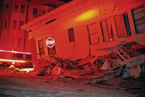
- A timely wake-up call? The 1989 Loma Prieta earthquake,centered along the San Andreas Fault in Santa Cruz County, causedsignificant damage in several widely dispersed locations around the BayArea, including the Marina District of San Francisco. Photo: (c)HerbLingl, www.aerialarchives.com
Of course, the same forces that shape the dramatic landscape, and that make this region such a beautiful place to live, are also capable of violent destruction. This fact is too easily ignored, as the earth under Northern California has been suspiciously quiet since the great earthquake of 1906—except for the Loma Prieta quake in October 1989. Earthquake hazards geologist Mary Lou Zoback and her colleagues at the USGS have studied the history of temblors in the Bay Area and found that during the 70 years before 1906 the region sustained 18 destructive quakes of magnitude 6.0 or greater. Between the arrival of the Spanish padres in 1776—marking the beginning of our historical record—and 1835, the earth under Northern California was also rather quiet without any notable temblors. “We don’t know if this oscillation between quiescence and strong earthquake activity is a regular pattern or not,” says Zoback. The record of just 230 years is far too short to draw any statistically relevant tectonic conclusions.
Nevertheless, strong earthquakes have certainly been a regular feature in the Bay Area for tens of thousands of years, and that is not changing any time soon. Geologists have learned about the shakings in the prehistoric past by studying the walls of trenches dug across active faults to depths of ten feet or more. The information about past temblors is written in the sediments that form the walls of the trench. Each earthquake interrupts the regular layers of sediment and leaves behind a pattern of jumbled “wallpaper.” Using charcoal and other organic materials in these layers, geologists can date intervals between the disruptions over much longer periods. Zoback explains: “The average recurrence time of strong earthquakes along the Hayward Fault is about 150 years, and the last four quakes have been 130 years apart.” As the last destructive earthquake on the Hayward occured in 1868, the next one is almost overdue.
This fact also shows in Bürgmann’s measurements of the movement, which reflect precisely what Reid had theorized about in the Lawson Report. The rocks of the earth’s crust under the Bay Area are currently being elastically loaded due to the continuous movement of the plates. It is only a matter of time until the strain gets too large again and the crust rebounds, giving way in a major earthquake.
Taking all these various pieces of information—the measured rate of slip, the time interval between earthquakes, and the strength of the shaking—into account, seismologists at the USGS have come up with a prediction of the likelihood of future earthquake activity in the Bay Area. According to this analysis, the probability is more than 60 percent that the Bay Area will experience an earthquake of magnitude 6.7 or greater by the year 2032. The greatest risk is on the Hayward Fault along the East Bay hills and the associated Rodgers Creek Fault between San Pablo Bay and Santa Rosa, with a 27 percent likelihood on that fault system alone. The Loma Prieta earthquake of 1989 has reduced the tectonic load along the San Andreas Fault somewhat. But the likelihood that San Francisco will be hit directly by an earthquake similar to the one in 1906 is still 21 per-cent over the next 26 years.
In the century that has passed since San Francisco was devastated by the earthquake and subsequent fire, our understanding of the causes of earthquakes has evolved considerably. Seismologists have measured the tectonic forces that lead to temblors and have learned to calculate the risks involved. Engineers have devised methods to make buildings withstand the shaking without collapsing and burying people inside. Major infrastructural arteries are being retrofitted or—as in the case of the Bay Bridge—rebuilt, to enable them to survive even strong temblors. But given that there is still no way to predict precisely where or when an earthquake will occur, an individual’s ability to survive a major temblor and its aftermath depends largely on a combination of preparedness and luck. The constant uncertainty and the necessity of preparation are perhaps the highest price—higher even than the region’s soaring real estate values—that residents of the Bay Area must pay to live and survive in this beautiful, but volatile, corner of a world that is always in motion.
-300x96.jpg)