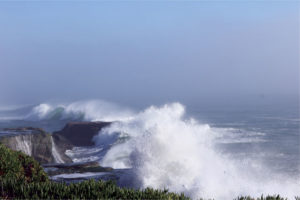
While many people feel the winter of 2015-2016 was a bit of disappointment—a betrayal even, since we didn’t get a record-busting Godzilla like 1982-83 and 1997-98 — I’m not one of them. Remember back in your science classes when you learned that scientists are just as interested in being wrong as being right, or that a busted hypothesis was equally important as one substantiated? Well, we can learn a lot from this quirky El Niño. Some forecasts were right on the money while others were consistently wrong, and now, as El Niño’s unpredictable twin sister La Niña strengthens, it’s worth asking what lessons there are to take from the 2015-2016 winter.
Remember, they are an exotic species in the Western United States, and are rapidly increasing their geographic range and range of habitats. Are they outcompeting or excluding native species in the process? How would we know? We have done almost nothing to monitor changes in the assemblage of mushroom species in areas before and and after the incursion of death caps.
Further Reading
Pringle et al, “The ectomycorrhizal fungus Amanita phalloides was introduced and is expanding its range on the west coast of North America,” Molecular Biology 2009
Lockhart et al, “Simultaneous emergence of multidrug-resistant Candida auris on 3 continents confirmed by whole-genome sequencing and epidemiological analyses,” Clinical Infectious Diseases 2017
Battalani et al, “Aflatoxin B1 contamination in maize in Europe increases due to climate change,” Scientific Reports 2016
El Niño: Beyond the Hype

Bay Nature goes beyond the headlines to explore what the strongest El Niño in recorded history might mean — or not — for Northern California. We’ll post new articles here throughout the fall and winter.
This series has been funded by donations from Bay Nature readers. Please help us by sharing our work, or donate today to support our mission to explore the natural world of the Bay Area.
A Brief Review of the Past Winter
First of all, here’s a reminder about what happened:
- Central and Northern California received slightly above average rain and snowfall, while Southern California was abnormally dry.
- This dry Southern California was notable because that part of the state often receives copious rainfall during El Niño events, particularly during those categorized “very strong,” as was the case for this past winter.
- Even in Northern California, though, we did not receive the record-breaking 180-200% above average amounts of rain and snowfall that we did during the last two very strong episodes (1982-83 and 1997-1998). Instead our rainfall anomalies were modest, a bit more or less of 125%.
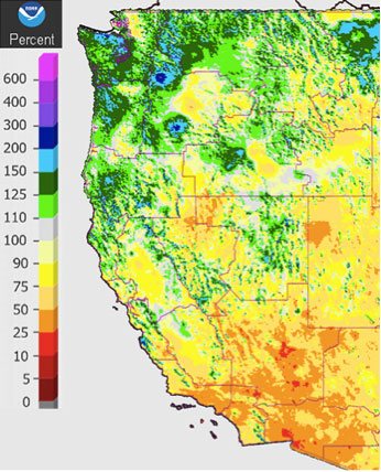
- The highest anomalies, the Godzilla El Niño if you will, went north into Oregon and Washington. Here’s a map of the west showing rainfall seasonal rainfall anomalies through the end of April. Note not just the wetness in western Washington state but also the negative anomalies in southern California where NOAA 90-day precipitation outlook models forecast considerable wetness:
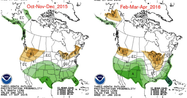
Which brings us to those 90-day outlooks (not forecasts, mind you). Here are two of them, one from early in the season, another from mid-winter. These 90-day outlooks dramatically missed the boat by showing high probabilities for an anomalously dry Pacific Northwest.
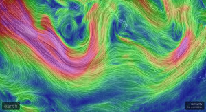
Why Did Both Theory and Computer Models Predict Rain in Southern California and A Dry Pacific Northwest?
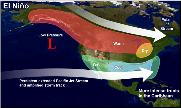
Up until this year, the standard model for El Niño effects was that warm water off the coast of southern California energizes the sub-tropical branch of the Pacific jet stream, steering storms into the southern portions of North America, from southern California eastward across the Gulf States. With moisture-laden Pacific storms captured by the sub-tropical jet, the northern polar jet would run dry, which is why all the forecast models predicts drought for the Pacific Northwest. Also important to this conventional wisdom is the role of the Aleutian low pressure system. Its counter-clockwise rotation pumps warmer air from the sub-tropics northward, which explains the warm-and-dry forecast for the northern part of the continent.
What Really Happened
As we reported in January this year’s El Niño was taking on quirky traits, with the polar branch of Pacific jet remaining in firm control and steering most storms into the Pacific Northwest. This satellite image, for example, shows a well-defined atmospheric river providing the moisture tap for series of wet storms.
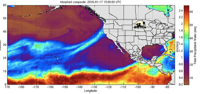
The image, however, does capture two important explanations for the unanticipated effects of this winter’s El Niño: a ridge of high pressure between Hawaii and the southern California coast that split the Pacific jet, and a weaker Aleutian low.
This splitting effect, which sent storms north instead of into southern California, is described in our January post (in which I also wrongly predicted the southern branch would strengthen in February and March). And the ridge of high pressure that either split the Pacific jet or actually redirected it northward could have been caused by increased winter-season strength of the Hadley Cell, an atmospheric circulation system better known for creating our summer-time Pacific High.
A Hadley Cell moves heated air from the equatorial zone upward, and then poleward, where it then descends, creating surface high pressure. The northern hemisphere Hadley Cell is most active in the summer season, when solar heating is greatest on our side of the Equator. Not only does this descending air create the Pacific High that is responsible for California’s dry summers, but it also drives the prevailing northwest winds that drive our offshore oceanic upwelling system.
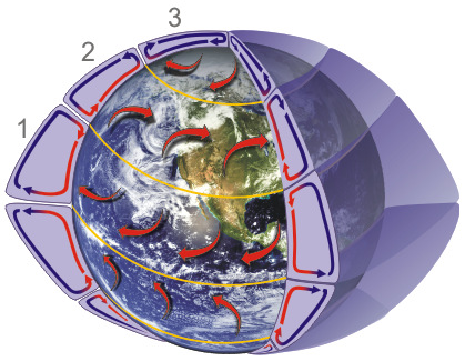
What caused this unusual strengthening of the winter-season Hadley cell is unclear at this point (at least to me), but the implications could be huge if this feature becomes a permanent part of our West Coast climate system. Summers could become windier and perhaps foggier, autumns could become drier, and Southern California might see less and less winter-season rainfall. I don’t think this strengthening of the winter-season Hadley Cell is an inevitable product of global warming — at least right now.
The role of a weakened Aleutian low in producing the observed rainfall pattern is less clear, although I would opine that instead of pushing the polar jet northward as in a “typical” El Niño, it allowed that branch of the Pacific jet to stay on its southern fringe where it could actually enhance — rather than inhibit — storm development.
What Did We Learn from This Winter’s El Niño?
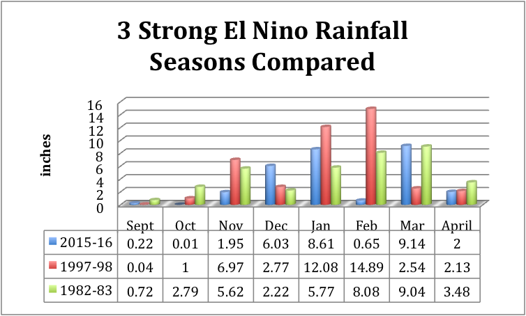
Most obvious is that all El Niño’s are not the same and the ENSO template for California must be revised. To reinforce that point I charted monthly rainfall figures in Oakland for this winter’s rainfall compared to that of the two most recent very strong El Niños. The intra-and inter-seasonal variability alone should have cautioned us about making Godzilla-like predictions:
Second, the media should try to avoid sensationalizing the possibility of extreme weather events before they happen. That’s particularly worth keeping in mind as we move from El Niño to a predicted strong La Niña, and front-page newspaper headlines are already declaring a continuation of the drought.
Finally, the public must keep pressure on our politicians to fund climate-change science. While I’m not sure many people suffered from the errors in this winter’s forecast (except maybe those in southern California with a surplus of sand bags in their front yards), the more we know about global warming and climate change, the better prepared we’ll be. California has the largest population living in, and the highest value economic system dependent on, the world’s most highly variable rainfall regime. NOAA has described El Niño as the best predictor we have of rainfall, and this year it didn’t work out as advertised. We’re all better off if we figure out why, and adjust our thinking. As the pundits like to say, “there’s no such thing as average rainfall in California: there’s either too much or too little.”