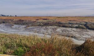
San Francisco Bay is clearing up. Its waters may never have the sparkle of a receding wave on Maui. But someday you might be able to walk out into the Bay till your belly button gets wet and still see your feet. As it turns out, however, this might not be such a good thing.
The Bay’s turbidity–its dirty, muddy, cloudy quality–is legendary among estuarine scientists. That’s why in 1999, when they conducted their annual monitoring of suspended sediment in Central Valley river flows into the Bay, they were shocked to find half as much as in the prior year. The sediment in question is mostly tiny mineral particles of silt and clay that can drift in the water or settle onto wet surfaces and make “mud.” The finding wasn’t a data glitch; sediment concentrations have stayed lower ever since. And it’s so big, scientists call it a “step change.”
While this step change may be intriguing to scientists–it has inspired a raft of new research–most people might be excused for not getting too worked up over having less mud in the Bay. Still, for marsh managers, it’s becoming topic number one.
“Mud is San Francisco Bay’s habitat engineer; it’s the foundation of our subtidal, mudflat, and marsh habitats,” says Amy Hutzel, Bay Area program manager at the State Coastal Conservancy, an agency that has itself engineered a lot of wetlands. As the conservancy and its partners restore thousands of acres of wetlands around the Bay, they’ve been counting on waves and tides to keep depositing plenty of sediment on our shorelines for decades to come.
Hutzel doesn’t mince words on the sediment subject: “We can’t let any more mud go to waste. As we’re out there dredging our ports, marinas, and flood control channels, as we’re digging up dirt around the Bay to do construction, we need to make the best use of every bit of dirt we can to help sustain our habitats and wildlife.”
The drop in sediment supply wouldn’t be such a concern if sea level rise wasn’t coming at San Francisco Bay like a freight train, at least on a geologic timescale. The National Research Council predicts a regional rise in relative sea level of 17 to 66 inches by 2100, and researchers agree that the rate of rise will pick up speed around the middle of this century. While today’s marshes naturally keep pace with sea level rise by trapping sediment, growing plants, and expanding up and out, by mid-century the water will start to get higher faster than the marshes can.
“We’ve got two major stressors on our wetlands on different trajectories. We have sea level rise, which is accelerating, and the suspended sediment supply in the Bay, which is diminishing,” says Jeremy Lowe, Climate Change Director for ESA-PWA, a consulting firm that’s been restoring wetlands since the 1970s. “Current accretion rates will probably keep our big marsh plains going into 2050 or 2070, but if some of these higher sea level acceleration rates come to fruition, our marshes won’t be able to keep up.”
So why has the Bay’s mud supply shrunk? Historically, sediment got into the water via erosion and runoff upstream. Then, starting in the 1850s, hydraulic gold mining blasted whole hillsides’ worth of sediment into foothill streams and down into the Bay. But soon after all this dirt was unleashed, humans got busy putting obstacles in its path. So there’s a lot of sediment now stuck behind dams, held in place by riprap, or buried under concrete.
“Estuaries are natural sediment sinks, but for all these reasons less and less sediment is reaching the Bay from the watershed,” says the region’s preeminent mud scientist, David Schoellhamer of the U.S. Geological Survey. Judging from the step change he saw in 1999, he thinks the mining debris is finally washing out of the system, and his USGS colleague Bruce Jaffe has shown that the San Pablo Bay floor, where mining sediments were deposited for many decades, is now eroding.
These two mudrakers are among several dozen scientists from the USGS, the University of San Francisco, PRBO Conservation Science, the San Francisco Estuary Institute, and other organizations who have contributed research papers to a forthcoming special issue of Marine Geology on Bay sediment. The 20 papers explore everything from where the Bay’s sediment supply comes from (“provenance”) to how it moves through the water (“transport”) and where it ends up (“deposition” and “accretion”). They account for factors such as surf zone dynamics, tides, waves, topography and something called “flocculation”— fine grains don’t usually drift all alone but clump together into “flocs,” which amass more rapidly (“settling velocity”) on the marsh plain than individual grains do. Heady stuff.
Despite the complexities, scientists do seem to be getting a handle on changes in the Bay’s sediment supply. Whereas historically the supply coming down from the Sacramento and San Joaquin rivers and through the Delta outpaced the supply from local Bay tributaries by a factor of eight to one, today sediment loads from local watersheds make up more than half the supply. Meanwhile, the average amount of sediment floating around in Bay waters has dropped by one-third, from 75 to 48 milligrams per liter (mg/l), according to Schoellhamer.
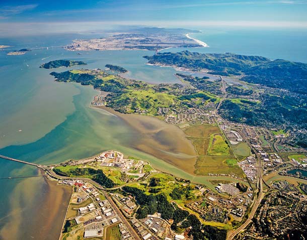
Of course, some areas of the Bay are more sediment-rich than others, and in these spots wetlands may fare better as the waters rise. Two good places seem to be the shorelines in the shallower northern and southern reaches.
According to studies by environmental scientist John Callaway at the University of San Francisco, natural marshes typically accumulate about three to five millimeters of sediment per year, while current rates of sea level rise are two to three millimeters per year. Newly restored low-elevation ponds in sediment-rich areas build up much faster than natural marshes. In former salt pond a21 near Alviso in the South Bay, Callaway measured an accumulation of 10 centimeters in the year after the levee was breached, letting the tides get to work importing sediment. Unfortunately, such fast accumulation rates aren’t sustained once the deep spots fill in.
Information like this on local accretion rates, as well as other data on specific shorelines, is now being fed into a variety of computer models. A team led by PRBO’s Diana Stralberg, for example, ran 70 scenarios for climate-changed marsh development over the next 100 years in 15 subregions of the Bay. The resulting prognosis for long-term marsh sustainability under a high-sea-level-rise scenario: “bleak,” if sediment supply continues to dwindle.
Bleak or not, anyone with a home, bike path, or business on the bayshore, as well as those relying on our sea-level airports and freeways, desperately needs every wetland we can get. Having a buffer of wetlands between urban development and the Bay promises to mute, dampen, and absorb the shock of sea level rise and extreme storms. As such, getting shorted on the sediment side has driven restoration managers to think creatively about how and where to get more dirt.
At the former Hamilton Air Base near Novato in Marin, the Coastal Conservancy and Army Corps of Engineers are transforming 650 acres once frequented by fighter jets into a mosaic of wetland habitats. The site encompasses a wild fringe marsh at the edge of the Bay, thick with pickleweed and cordgrass, then a big levee, and inside that, a flat lunar landscape that, until recently, was significantly below sea level.
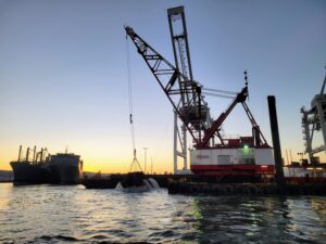
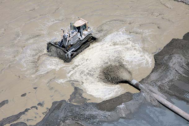
A key and novel ingredient in the plan was to use what everyone else was trying to get rid of at the time. With the help of nearly six million cubic yards of Bay mud dredged from the Port of Oakland to deepen the harbor, engineers were able to build Hamilton up to a level where marsh plants imported by tides could eventually take root.
To get that sediment from the bottom of an Oakland shipping channel to a field in Novato took some doing. Engineers had to build a five-mile-long pipeline from the Bay onto the former air base, and put it up on blocks in places so that endangered clapper rails and marsh mice could move freely under it. At one end, in a spot deep enough for scows to navigate, stood an off-loader with a crew where dredged sediment could be dropped off, mixed into a slurry, and then pumped into the pipeline and onto the marsh.
Planners are sure that when the new marsh is opened to the tides in 2013, it will be a success. But the price tag for the off-loader turned out to be pretty steep. So the conservancy is looking at alternatives for the Bel Marin Keys phase of the Hamilton project. One is an “aquatic transfer facility”— basically a depression dug in the bottom of the Bay, where dredgers could dump the sediment for storage until it’s needed later for restoration work.
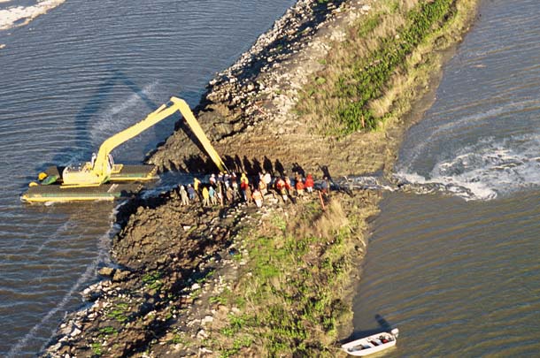
In the South Bay, wetland designers have also had to get creative about getting sediment. To restore Bair Island, an ecological diamond in the ring of South Bay marshes that make up the Don Edwards San Francisco Bay National Wildlife Refuge, the first step was to build up the sunken inner island. “If we had just breached the levee, it would have been deep water for a couple of decades,” says John Bourgeois, director of the South Bay Salt Pond Restoration Project.
Looking around for sediment, planners recently secured a completely new source, and it’s not from the bottom of a local harbor. In what Bourgeois calls a win-win arrangement, contracts were signed with some local “dirt brokers” happy to have a closer, cheaper place to dump material from their upland construction sites than landfills. The dirt brokers will not only test the dirt for contaminants before trucking it to the Bay, but also bring their dozers and Cats back later to do maintenance–always a problem for the cash poor refuge–and pay for continued monitoring.
Planners also want to use the dirt to experiment with some more specialized adaptations to sea level rise—upland transition zones for marshes hemmed in by levees and urban development. Instead of an abrupt transition between the marsh and the levee, they want to build a gradual gentle slope on the Bay side. “We’re hoping to find some magic balance, some optimal slope that will provide room for our special-status plant species and escape cover for our endangered birds and mice, while allowing marsh transgression with sea level rise,” Bourgeois says.
These tales of mud and science are just the molehill in a mountain of attention now being paid to the sediment management question baywide. At the Bay Conservation and Development Commission (bcdc), planners are working to update regional dredging and disposal priorities in light of sea level rise. And local engineers are brainstorming ways to feed more sediment to wetlands.
When talking with any of these planners, engineers, and scientists, the sense of urgency is hard to miss. No one wants to see a negative step change in marsh acreage occur in mid-century because we didn’t give the region’s wetlands a good foundation for adaptation. And that foundation must come from dirt–in whatever form.
“Bay mud, especially from our harbors, used to be considered ‘toxic’ spoils to be gotten rid of as expeditiously as possible,” notes bcdc chief deputy director Steve Goldbeck. “Now it’s a scarce resource and everybody’s trying to figure out how to get more of it and move it around. It’s really changed how we perceive sediment in the coastal management world.”
Ariel Rubissow Okamoto, the editor of Estuary News, the bimonthly newsletter of the San Francisco Estuary Partnership, is also the author of The Natural History of San Francisco Bay (UC Press, 2011) and of numerous articles on Bay Area watersheds.