.jpg)
I love the beach and marsh at Pescadero, the way the light changes by the hour, the drama of waves pounding the rocks, the stillness of the marsh at dawn. Among all the other treasures on the southern San Mateo coast, Pescadero stands out for its diversity and beauty. I learned the dabbling ducks here one winter, and marvel still at the bewildering varieties of shorebirds in spring. I’m impressed by the enduring presence of the San Francisco garter snake, even though I never expect to see it in the wild. I know the sorrow of ice plant stifling the living sand and the joy of seeing volunteers pull it out. This is Pescadero as I have experienced it, a catalog of sights and sounds, of days at the beach, too many months between visits, and years of returning to a favorite place.
Amid the hours and days of keening gulls and booming surf, there’s also the knowledge that some sights and sounds lie beyond our ken. Our eyesight, as miraculous as it is, is not all it could be. If we could perceive ultraviolet like a bumblebee or infrared like an owl, our world would be quite different, perhaps even more chaotic and overwhelming than cable television. Infrared goggles and other tools help extend our ability to perceive wavelengths beyond the visible spectrum, but our perception of time is not as amenable to mechanical enhancement. Instead, we must rely on imagination to deepen our experience of time. Perhaps a few props will help us understand change over the millennia. Here are a few postcards of old Pescadero found in the attics of the physical sciences.
Geologic time
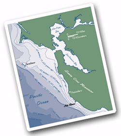
Fossicking about in the cupboards of geology yields our first treasure, a map of the Pescadero area. One of the two bold lines cutting across it is the Frijoles Fault, one of several faults in the San Gregorio Fault zone, which is, in turn, part of the larger San Andreas Fault system. The San Andreas and the Frijoles are known as right-lateral strike-slip faults, which means in part that lands west of the fault are moving north relative to those east of it. The Frijoles has been active for only 10 million years or so, but that’s long enough to have generated 90 or more miles of slip.
Sag ponds and rerouted creeks are visible reminders of activity along faults like the San Andreas and Frijoles. Among the most familiar are the chain of sag ponds—now converted into reservoirs—associated with the San Andreas and visible from i-280 north of Woodside. Our map shows how the lower reaches of Butano Creek, obstructed on its way to the ocean by the northward-moving Pigeon Point Block, may have been captured by the Frijoles, forcing it to run north and join up with Pescadero Creek instead of flowing directly to the Pacific.
12,000 Years ago
The next postcard came from a yard sale held by a retiring palynologist, someone who studies pollen. It’s fun to read other people’s mail! Here’s what I found scrawled across the back: “Drilled a core in a tiny marsh in the hills east of Año Nuevo. Didn’t expect to find grand fir so far south. Cool—yet another range shift!” In order to make sense of this cryptic message, let’s visit Pescadero and the nearby peninsula of Año Nuevo around 12,000 years ago, just as grand fir was disappearing from the Santa Cruz Mountains.

- Ben Pease
Back then, Pescadero Marsh didn’t even exist. The confluence of Pescadero and Butano creeks was probably in a forested canyon nearly 70 feet below the current level of the land, excavated to bedrock by the scouring waters of the combined creeks. As it headed west, Pescadero Creek carried its burden of sand and silt out to a broad coastal plain. This plain—the Outer Outer Sunset, let’s call it—extended from the Farallon Islands south past Año Nuevo and probably featured extensive sand dunes along much of the coast.
Twelve millennia ago, Pescadero Creek entered the ocean at the western edge of this plain. Sea level at that time was roughly 300 feet lower than it is today. By then, after many millennia of cool “glacial” conditions, temperatures were rising, the great continental ice sheets had begun to melt, and the world’s oceans were steadily regaining their waters. During this ancient period of global warming, the shoreline retreated east as the Pacific flooded the Outer Outer Sunset and the lower reaches of Pescadero Creek. The sediment the creek once deposited on the coastal plain began to settle out farther east, filling the bedrock canyon near the confluence of Pescadero and Butano creeks.
How did plants and animals respond to such dramatic environmental changes? During glacial times, some intertidal species expanded their range south in response to cooler water temperatures along the California coast. Rising temperatures forced these ambassadors from the north to retreat. A similar process occurred among land plants. As global warming elevated temperatures and decreased precipitation, the area around Pescadero became less tolerable for grand fir, one of many northern species that had found a home in the Santa Cruz Mountains. For more than 10,000 years, grand fir had been the dominant tree in the conifer forests around Año Nuevo, but the time had come for it to move on. The southernmost station for grand fir is now along the Russian River in Sonoma County.
Even coast redwoods, those exemplars of the deeply rooted ancients, migrated. At the same time the grand fir were becoming scarce, coast redwoods became more common around Año Nuevo. During glacial times, they were apparently restricted to the cooler and wetter interior—if they were even this far north. As the climate changed and the coast itself migrated east, the redwoods advanced from the interior toward the foggy coast.
We know all this—and lots more—because a few scientists waded into the muck in a little marsh above Año Nuevo and extracted more than 2 meters of smelly marsh sediment that represented a record of the nearby vegetation spanning roughly 25,000 years. Thank goodness we have only the postcard, not their socks.
- Tchell dePaepe
3,200 Years ago
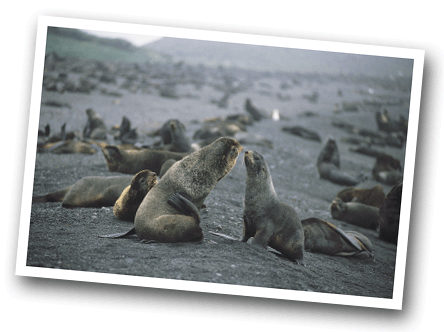
Our next postcard was found among the shells and bones stashed away in the trunks of archaeology. There’s nothing written on the back, but the image shows a baby northern fur seal and its mother lounging on the beach at Año Nuevo around 3,200 years ago. We know that many northern fur seals hauled out there because their bones dominate nearby middens, the concentrated collections of shells, bones, charcoal, and (occasionally) human burials associated with seasonal camps or villages of the indigenous peoples of the California coast. One nearby midden contained the remains of more than 140 individual fur seals, representing 96 percent of all the pinniped bones in the midden. Año Nuevo wasn’t a special case, either. Northern fur seal remains dominate middens all along the San Mateo coast.
Nowadays, Año Nuevo is far more famous for elephant seals. But here’s an amazing fact: among the tens of thousands of pinniped bones excavated from local middens, not a single one belongs to an elephant seal. That’s right; according to the archaeological evidence, nearly every other pinniped—California sea lions, Steller sea lions, harbor seals, and sea otters—could be found here, but not elephant seals. Where were they? We don’t know. However, whereas the prehistoric ecological relationships among pinnipeds may always remain a mystery, the archaeological record helps clarify the relationship between northern fur seals and their most important predator: humans.
For more than 7,000 years, hunters along the central California coast harvested thousands of northern fur seals from mainland rookeries. But eventually the fur seals got wise, it seems, and began to abandon the mainland. Beginning around a thousand years ago, northern fur seals become much less common in excavated middens. Northern fur seals from Alaska to Baja California now give birth to their pups exclusively at offshore rookeries, such as the one established recently on the Farallon Islands. As with grand fir, the breeding range of northern fur seals shifted to reflect changing conditions. Unlike with grand fir, the shift in northern fur seal behavior was probably caused by humans.
November, Late 1860s
On an early November day in the late 1860s, a young journalist visiting Pescadero had “the best morning’s sport” he’d ever enjoyed. Albert Evans walked the “wildly romantic” beach, watched two wolves playing in the breakers, marveled at the sea anemones among the tidepools, dipped crabs from the creek, caught 14 salmon in a few hours of fishing, and—being an “inveterate sportsman”—rounded out his day by dispatching several sea lions swimming at the mouth of Pescadero Creek with his revolver. He then sailed back up the creek to Pescadero’s Swanton Hotel on the evening tide.
Hunting and fishing weren’t the only attractions that brought tourists to Pescadero. During its heyday as a destination resort in the 1860s and 1870s, Pescadero offered more gentle diversions such as gathering moss and pebbles. By then, the Victorian enthusiasm for the picturesque seaside and its natural “curiosities” had become fashionable in California after being wildly popular in Great Britain a few decades earlier. By the early 1860s, women and children in New England as well as California were spending hours collecting “sea-mosses,” or algae, which they carefully pressed and dried in albums or mounted in picture frames. The collecting impulse—what we’d call beachcombing—extended to shells and pebbles as well. Such objects sprawled across mantels and stuffed the “cabinets of wonder” found in the homes of the middle class. Early promoters dutifully advertised the availability of such diversions by naming nearby beaches for the sought-after objects they contained. Pescadero, one of the earliest seaside resorts in California, claimed all three: a Moss Beach, a Shell Beach, and a Pebble Beach. The last still endures as a place name, but it doesn’t rouse as much enthusiasm as it once did. More than a hundred years ago, conflicts over access to that beach escalated into the great Pebble Beach War.
The war was sparked in the early 1890s, when one of the county’s largest landowners tried to restrict public access to Pebble Beach. For three decades people had wandered over the farmland west of Pescadero on their way to Pebble Beach, but now they encountered fences. A long legal and political struggle ensued. But in a way it was moot. Once tourists began to travel by rail, resorts without rail access, such as Pescadero, fell into disfavor. It would not be the last time, however, that residents had to fight to retain access to San Mateo’s dramatic coastline.
March 2, 1938
At high tide on an early spring day in 1938, the methodical naturalist Robert Orr snapped a photograph of Pescadero Marsh. A curator at the California Academy of Sciences, Orr had been systematically visiting Pescadero and nearby Big Basin as part of an extensive study of its birds. Over a four-year period, Orr spent 176 days making notes about the birds of the area.
Orr’s notes and photographs illustrate how much things at Pescadero Marsh have changed since then. Ravens, he noted, were seen only twice during his 176 days in the field. Now they are much more common in the area, most likely thanks to the garbage dump nearby.
The marsh itself looked rather different back then. In brief, there was less dirt and more water than there is now. For centuries, ever since the marsh was born, Pescadero and Butano creeks had been depositing sediment in the marsh as their waters slowed to meet the ocean. But the sedimentation rate increased dramatically in the 20th century due to logging, road building, and overgrazing in the watersheds of the two creeks. There was less freshwater entering the system, particularly during the summer as farmers diverted water for agriculture. Even salt water became less abundant as farmers built levees to hold tidal waters at bay as they converted eastern sections of the marsh to artichoke fields. All these forces—not to mention the building of Highway 1 in 1938 along the back edge of the barrier beach—combined to transform the system’s hydrology.
As he tromped around the marsh at Pescadero, Robert Orr might not have detected such changes, but he knew one thing for sure: it needed to be saved. Back then, the only nearby protected lands were the state park at Big Basin and Memorial County Park upstream from Pescadero. “Each year,” Orr lamented, “it becomes more difficult to visualize this region as it existed primitively.” But he hoped that “at least part of this coastal region may ultimately be acquired as a wildlife sanctuary,” thereby protecting the largest coastal marsh between San Francisco and Monterey. Thanks in part to his work, much of the marsh was bought by the state a few decades later.
.jpg)
