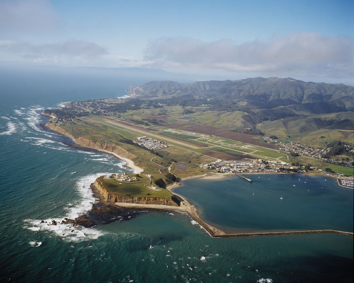
Francisco Guerrero y Palomares showed some singular foresight when he drew up a crude map in 1838 and said to the then-governor of Alta California something like, “That piece of land. That’s the one I want.” The young Mexican settler, who also served for a time as alcalde (mayor) of the small settlement at Yerba Buena (San Francisco), sketched out a roughly 7,700-acre rancho for himself encompassing the coastline of modern-day Montara State Beach south to the Miramar community and east to the first string of mountains. He undoubtedly liked the open grasslands for grazing his herds of cattle, the fertile soil, and the freshwater creeks. There were the dramatic mountains rising to the east, creating a natural barrier for livestock and earning the area its name Rancho Corral de Tierra (corral of the earth). Perhaps Guerrero also hoped that the parcel’s steep boundaries and rugged shoreline would offer protection from advancing Americans as they claimed California for themselves in 1846, pushing out Mexican nationals like himself.
Those appealing qualities have continued to lure generations of ranchers, farmers, and people seeking tranquility and beauty to this coastal landscape. Rancho, as it is now most often called, was the stomping ground of Mexican cowboys, a refuge for booze-smuggling artichoke vendors, and the site of some grandiose development dreams. Despite this history, the land itself hasn’t changed much, which has set the stage for Rancho’s newest incarnation as the site of the most recent addition to the Golden Gate National Recreation Area. The remaining 4,000 acres of Guerrero’s parcel will now help to complete one of the largest swaths of open space in San Mateo County.
In 2015, the National Park Service is inviting the public to weigh in on Rancho’s next stage. After three years of preparation and investigation—from vegetation surveys and archaeological reviews to a search for salmon and meetings with locals—the service will hold public meetings on the location of trails, parking lots, and bathrooms and on what kinds of programs to offer on the property. It’s time to open up a storied, long-private piece of the coast for all.
While the park is open to the public, access remains difficult. So the Golden Gate National Recreation Area’s Susie Bennett, a natural resources specialist whose job it is to know about the park properties in San Mateo County, agreed to give me a tour of Rancho. We begin our fog-engulfed morning by skirting the northwestern edge of the park on a path that rises from the flat farmland abutting Highway 1 into the grassy foothills of Montara Mountain, the landscape feature that dominates the new park. The quartet of peaks forming Montara Mountain shoot up almost 2,000 feet from the ocean, and Bennett convinces me we should climb to the top. “Biologically it’s the most interesting—it’s like a moonscape,” Bennett says.
Remember, they are an exotic species in the Western United States, and are rapidly increasing their geographic range and range of habitats. Are they outcompeting or excluding native species in the process? How would we know? We have done almost nothing to monitor changes in the assemblage of mushroom species in areas before and and after the incursion of death caps.
Further Reading
Pringle et al, “The ectomycorrhizal fungus Amanita phalloides was introduced and is expanding its range on the west coast of North America,” Molecular Biology 2009
Lockhart et al, “Simultaneous emergence of multidrug-resistant Candida auris on 3 continents confirmed by whole-genome sequencing and epidemiological analyses,” Clinical Infectious Diseases 2017
Battalani et al, “Aflatoxin B1 contamination in maize in Europe increases due to climate change,” Scientific Reports 2016
GETTING THERE: As of January 2015, Rancho had no official parking or visitor center, so NPS recommends parking at nearby Gray Whale Cove State Beach, on the east side of Highway 1 just north of Montara. From the Gray Whale Cove parking lot, trails lead east and south through McNee Ranch State Park to the summit of Montara Mountain and a wider connection with the trails of Rancho Corral de Tierra. Other public access to Rancho involves parking legally in nearby residential areas, such as near Renegade Ranch in Montara.
We begin marching up a steep hill and the fine, crunchy gravel beneath my feet reminds me of Yosemite and Tahoe. I mention this to Bennett and she explains that it is, literally, of a piece with those places. Unlike most GGNRA sites, Rancho sits atop granite that marks the northern end of the Santa Cruz Mountains. The granite comes from a 100-million-year-old formation that was originally part of the southern end of the Sierra Nevada but was broken off by the San Andreas Fault and transported north on the eastern boundary of the Pacific Plate. For the moment, at least, this freewheeling hunk of granite is settled along the San Mateo coast, accounting for the quartzy yellow gravel in Rancho and the fine golden sand along the shores below us.
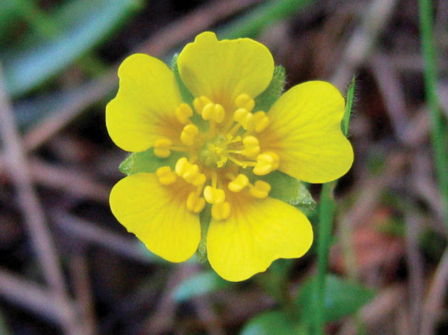
I think Bennett is steering me toward a rest spot, but instead she stops in front of an unremarkable patch of grass and kneels down. Using her index finger to lift a small, feathery leaf, she says, “This is Hickman’s cinquefoil, also known as Potentilla hickmanii.” This little plant, rather ordinary looking when not in flower, is an endangered species and endemic to San Mateo and Monterey counties, with the vast majority of the known occurrences of the plants growing at Rancho. The tiny plant has wielded outsize influence in determining the fate of the landscape to the west and north of Montara Mountain. Hickman’s cinquefoil was first identified in the area in 1905 and again in 1933, but was never again noted, despite many surveys. According to an article by local botanist Michael Vasey in a 1996 issue of the journal Fremontia, botanists believed the species no longer grew in San Mateo County and that the few remaining individuals in Monterey were marching toward extinction. But in 1995 Caltrans biologists, surveying the land as part of the permitting process for the controversial Devil’s Slide bypass project, stumbled upon an unidentified plant, which turned out to be Hickman’s cinquefoil, 50 years lost. And not just one plant but thousands. That discovery helped put an end to the bypass idea and to Montara Mountain’s fate as a freeway corridor.
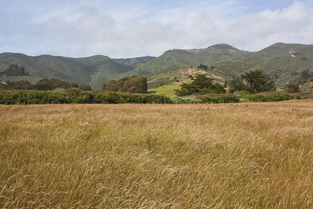
To support the fragile cinquefoil population—a priority for the National Park Service—Rancho has received funding to maintain and restore native ecosystems. That means restoring grasslands in the foothills and removing invasive species. “A cheater’s trick for identifying native grasses is to look for bunches,” says Bennett, as she points to a clump of blue wild rye. Growing nearby is purple needlegrass, designated California’s official state grass in 2004. Once upon a time it was the dominant grass in the state and is known to live as long as 150 years. There is also California oat grass, noted for secreting away a second set of seeds beneath its flower stalk, out of the reach of hungry grazers. Bennett and her colleagues hope to spread these perennial grasses, along with native wildflowers, across Rancho’s foothills, while taking out invasives such as Harding grass, once planted widely as a feedstock, and the ornamental pampas grass Cortaderia jubata. Bennett says, “We’re trying to come up with a vegetation palette that is biologically reasonable, with species that are aggressive enough to survive the nonnatives.” Then she adds, “and that looks pretty.”
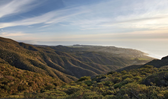
Bennett tells me it’s time to head for the peak, and we decide to hike up the Alta Vista Trail, which follows a natural ridge to the top of Montara Mountain. As we walk along the ridge, we’re flanked by coastal scrub. There’s a sharp smell of sage. We pass coast silk tassel and fruit-bearing coffeeberry. As the path turns steep and narrow with brush growing above our heads, I try to imagine traversing this vegetation without a trail, and wonder how the Ohlone and the Spanish — or Guerrero, for that matter — made it through.
We reach a level, open area that the wildlife has taken full advantage of, leaving a lattice of deer trails. The coyote brush and golden chinquapin are draped with wispy green lichen. A sculpted mound of grass is pierced by a mouse-size hole. Human researchers have taken advantage of the clearing, too: a few feet away Bennett unlocks a wildlife camera, slipping out the photo card. Later, she passes along new photos from the camera of a bobcat, a fox, a pair of coyotes, and a mountain lion. Researchers want to see if and how such wild animals benefit from the various forms of protection and stewardship the park will exercise here.
From this wildlife crossroads, the climb turns serious as we scramble up patches of exposed granite. The vegetation has begun to shift to maritime chaparral, a relatively rare habitat dominated by manzanita and other hardwoods, found only in pockets in coastal areas from the Bay Area south. We come across a San Mateo tree lupine (Lupinus arboreus var. eximius), a California native found primarily in San Mateo County and listed by the California Native Plant Society as rare and endangered. Some argue that the individuals found on Montara Mountain are distinct enough to be classified as their own species.
We sit for lunch on a granite outcrop, enjoying an expansive view of the foothills below and the Pacific Ocean beyond. Our ridge drops off to the east into a small canyon carved by Montara Creek as it trickles toward the sea. We can also pick out roughly the site of the Guerrero family’s 60-foot-long adobe, to the southeast of the Half Moon Bay Airport strip, and the bright green fields of Cabrillo Farms. After the Americans took California from Mexico, Guerrero continued to work in San Francisco, helping authorities sort out land ownership disputes until he was murdered in 1851. Reports suggest that someone who didn’t care for his expertise had him killed, but no one was ever prosecuted for the crime. Over the subsequent decades the land was sold off in parcels, with parts remaining in the hands of Guerrero’s sons until as recently as the 1920s.
Denniston Creek, named after the American who married Guerrero’s widow, flows past Cabrillo Farms, which abuts the park’s western boundary south of Moss Beach. Ed Lea’s family has farmed there since the 1930s, when his parents arrived from northern Italy among the waves of immigrants whose familiarity with Mediterranean climates helped them thrive on the coast. Lea, who was born on Rancho property, recalls how his parents and other new arrivals grew artichokes under orders from the organized crime bosses who all but controlled the U.S. artichoke market and sold the artichokes for huge profits back east. The farms were also part of a system for smuggling liquor up the coast to San Francisco during Prohibition.
In the mid-1990s, a handful of wealthy absentee landowners saw profits from a different source when they put Rancho on the market for $50 million. Jack Nicklaus designed a golf course, and big homes and a resort were in the works. But thanks in part to the dot-com bust, the required investment didn’t materialize and the nonprofit Peninsula Open Space Trust rushed into the breach, sensing the unique opportunity to protect a valuable piece of the California coast. POST had to not only raise a significant amount of capital; it also had to convince Congress to expand the boundary of the GGNRA at a time when many in Washington were resisting the expenditure of public funds on land acquisition.
In 2001, POST purchased Rancho for $29 million. It was a major success in the trust’s “Saving the Endangered Coast” campaign, which aims to preserve 20,000 acres along San Mateo County’s coastline and is the largest initiative of its kind ever undertaken by a local land trust. In keeping with the organization’s commitment to protect agriculture on the San Mateo coast, POST sold the 229 lowland acres of Cabrillo Farms to the Lea family, who had farmed the area for nearly a century, but always on short-term leases.
Even after the POST deal was done, some lamented Rancho’s designation as federal parkland. Paul Ringgold, vice president of land stewardship for POST, recalls the point person for the sellers repeatedly telling his team, “It’s such a waste, all that property. It would be so great to develop it and put it to good use. I just don’t understand.”
Ringgold chuckles and says, “It was interesting to get that kind of perspective.”
Local reactions have also been mixed. Residents of the communities around Rancho have grown accustomed to using the land without restrictions—creating informal trails, walking dogs off-leash, and driving off-road vehicles. Following transfer of the land to the GGNRA in 2011, acceptance of national park rules has been slow and at times strained.
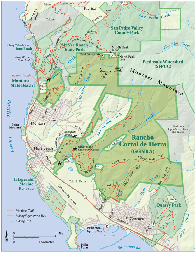
We continue up the steep grade until finally we’re on top of 1,830-foot Peak Mountain, marked by a pile of rocks left by previous hikers. I toss in a small contribution. Turning full circle, we take in the views of multi-peaked Montara Mountain: to the south is Montara Knob, a rounded dome rising above Montara Creek. To the east is South Peak, which mainly remains engulfed by fog that sweeps up in gusts from the creek. Then there’s North Peak, the highest of the four, reaching almost 1,900 feet and topped with a PG&E antenna tower. Between our peak and North Peak is an odd little valley, site of the confluence of property boundaries between the GGNRA, McNee Ranch State Park, San Pedro Valley County Park, and San Francisco Public Utility Commission watershed lands. That these lands all converge is significant. It means that the Rancho property is a core piece of what is now roughly 27,000 acres of contiguous protected open space. Having such a large swath of protected open space so close to San Francisco is surprising. And it’s extremely fortuitous for wide-ranging animals such as mountain lions, whose home ranges can easily extend 100 square miles or more.
To the west and south is the vast Pacific. The golden sands of Montara State Beach glow bright in contrast to the dark slate of the ocean. We can see the sweeping arm of Pillar Point Harbor, and beyond that the famous Mavericks surf break. Farther inland are the ridges above San Vincent and Denniston creeks. Everything is laid out before us as if on a map that spans generations, cultures, and geological eras. History is never out of view at Rancho; it’s folded into every crease and turn of the land.
.jpg)