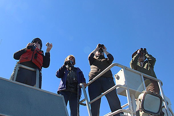
About 30 miles off the California coast, the R/V Fulmar barrels across open ocean. The Farallon Islands jut tooth-like above the clear horizon.
Aboard the research vessel, a scientist spots something that rouses the attention of the other on the observation deck.
“I think they’re blues. They’re blues!” says Jan Roletto.
“They’re blues,” her colleague Jaime Jahncke parrots.
“They’re blues,” Roletto says again.
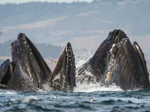
The researchers log the sighting: three blue whales. From this distance, the world’s largest mammal looks like nothing more than a silver glint on the ocean’s surface. But the spotting is significant to the researchers, who aim to protect the animals from passing ships as the whales enter these protected waters to feed.
Scientists from NOAA and Point Blue Conservation Science, in a partnership called Applied California Current Ecosystem Studies, or ACCESS, are using an iPhone and iPad application called the “Whale Spotter” that allows researchers and citizen scientists to easily record whale sightings in the area. The app works by pinning the location of the sighting onto a virtual map. The user can leave notes with the pin, such as the species of whale.

Ideally, the effort will help map out areas where whales tend to congregate, and then use the data to narrow down the potential overlap between whale and ship. Scientists hope that new technology might be able to lend a hand in tweaking shipping lanes or reducing speeds in areas with high whale activity.
When whale and ship meet, the results are often fatal. For blue whales, all it takes are three ship strike fatalities in one year to disrupt the species’ regional stability and threaten its recovery, said Mary Jane Schramm, a Gulf of the Farallones National Marine Sanctuary spokeswoman. There are between 2,000 and 3,000 blue whales in the region between California and Mexico.
“We can’t tell the whales where to go and the food is very, very patchy. It’s not always in the same spot throughout the seasons, or even in one season,” said Roletto, a research coordinator at NOAA Gulf of the Farallones National Marine Sanctuary. “Through analyzing years of data, they’ve been able to identify some really important hotspots.”
One hotspot, Roletto said, is the shelf break near the Farallones. Based in part on data collected over ten years of ACCESS studies, the Coast Guard and NOAA recommended an adjustment to shipping lanes outside the Golden Gate so that ships spend less time in the whales’ known haunts and foraging areas.
Over the course of this five-day cruise, the Fulmar’s crew of scientists is testing the beta version of the Whale Spotter. At the same time, other boats of volunteers are gathering data using the app.
Jahncke, ACCESS’s principle investigator and a researcher with Point Blue Conservation Science, will then compare the crowd-sourced data to data gathered by more traditional scientific methods. The comparison will tell him if and how scientists can use the crowd-sourced whale data in future projects.
“2010 was our year from hell in the San Francisco Bay Area for ship strike mortalities,” Schramm said.
Schramm described a fin whale that washed up dead on Ocean Beach and another whale floating near the southwest Farallon Island, both with clear boat and propeller injuries. At Pescadero Beach, a female blue whale and her fetus washed ashore after being struck by a ship.

Whales come to the ecologically rich Farallones to feed on krill. One of five major upwelling areas on the planet, the current moving alongshore stirs up sediments rich in nutrients that react with sunlight and spark the kind of oceanic productivity that fuels the diversity of life found here.
The islands, which are incorporated in a patchwork of three marine sanctuaries, are home to 13 species of seabird, plus seals, sea lions, dolphins and whales.
“(The islands) are a perfect bed and breakfast for marine life because they’re so rocky and inhospitable you can’t effectively land a boat,” Schramm said.
ACCESS tracks the health of marine ecosystem during its research cruises, keeping a proverbial finger on the pulse of the ocean. Their oceanic medical instrument of choice on a recent cruise was a long tubular net, called a Tucker Trawl, used to sample krill along a transect.
On the team’s first trawl, the device sunk too deep and the scientists wound up with a spotted prawn, a pink urchin and a mystery invertebrate that the researchers struggled to immediately identify (it was eventually settled: “some kind of nudibrae). A later effort later netted a giant egg-yolk jellyfish that made covered the deck in a giant, gelatinous pile on the back deck until Point Blue interns hosed the goopy mess back into the Pacific.

ACCESS also monitors water quality – temperature, depth, salinity and acidification – and shares the data with researchers around the state.
“So it’s like a huge wet jigsaw puzzle,” Schramm said. “There’s so much to study and this is kind of a crucible for putting all these bits of data together and finding out what it all means in the end.
“It’s like taking the temperature of the ocean and doing kind of a health check.”
The late-September cruise was ACCESS’s third and last outing of the calendar year. In the past, ACCESS was able to hit the seas five or six times a year for a week at a time. These days, due to budgetary constraints, cruises last only five days. The Fulmar, a NOAA vessel, is currently grounded with most other federal activities because of the government shutdown.
“When there are unexplainable variations within the marine ecosystem, that could mean something is going wrong,” Schramm said. “You need vessels in field and staff deployed to collect this information. So when we fall into these budgetary woes, that really imperils some of the validity of the data for some purposes.”
Sean Greene is a Bay Nature editorial intern.