.jpg)
San Francisco Bay presented a thrilling—yet possibly lethal—mystery to a young Spanish captain as he sailed up to probe the entry to the Golden Gate for the first time on the morning of August 5, 1775.
Juan Manuel de Ayala had heard the accounts of a vast, shimmering expanse of water seen by members of the overland Portolá expedition six years earlier. “A harbor such that not only the navy of our most Catholic Majesty but those of all Europe could take shelter in it!” Portolá’s chaplain, Frey Juan Crespí, had exulted.
Yet Ayala could not predict what hidden rocks or treacherous currents might lurk in that narrow entrance. As ocean swells pounded high cliffs on each side of the imposing strait, Ayala opted to send a skiff on a scouting mission. But as the rowboat disappeared from view, ebb currents of astonishing strength seized his packet-boat, the San Carlos, and hurled it back out to sea.
It was evening by the time Ayala regained his previous position. The second tidal ebb of the day had begun. But now, strong afternoon westerlies filled the San Carlos’ sails. Ayala had to fight past the mile-wide stretch between Lime Point and Fort Point, but finally managed to drop anchor near the sheltered willow-lined shore northeast of the strait by dark, where the errant skiff soon rejoined its mother ship. The name Ayala gave this anchorage—Sausalito, after the Spanish word for willow (sausal)—stuck, and it remains a haven for boats to this day.
THE FRICTIONLESS HIGHWAY
The San Carlos was the first European vessel to penetrate the Bay. But it would not be long before white sails and wooden hulls utterly displaced the tule reed canoes of the Coast Miwok and Ohlone. Ayala probably expected that new settlers would soon follow in his wake, to make their dwellings along the coves and among the round hills. But he never could have imagined that after just 225 years, the 5,000-10,000 native peoples living here when he arrived would be overwhelmed by 6.5 million new­comers and their descendants.
These newcomers would be drawn by many of the same charms that had made the Bay a haven for its aboriginal inhabitants: the mild, Mediterranean climate—temperate in winter and cooled by fog in summer—that the Bay itself helps create; an abundance of fish and game; and the broad swaths of accessible open space that—despite the never-ending flood of humans and their attendant structures—still ring the Bay with a breathtaking natural beauty.
The Bay and its abundant resources made people want to come here, and the Bay made it easy for them to make landfall and spread out. Its waters formed a superb natural harbor as well as a great, frictionless highway that opened up all of Central California, first for hunters and rancheros, then gold seekers, and finally, the proponents of every type of commerce. Today, Crespí’s vision has been realized, but it’s a diesel-powered stream of steel that dominates traffic on the Bay. Each year, more than 75,000 large vessel voyages make way on Bay waters, nurturing the region’s economic life. These include several hundred tankers, 4,000 freighters, 12,000 tugs towing barges, and three dozen cruise ships.
On any given weekend, the Bay’s rippling expanse also bears a few score modern sea kayaks, worthy successors to the Ohlone reed canoes and the walrus-hide baidarkas used by Russian traders and their Aleut cohorts to hunt for sea otter pelts during the early decades of the Spanish occupation.

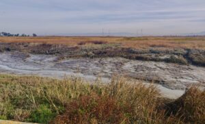
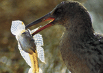
- The endangered California clapper rail survives on the bounty providedby the Bay’s tidal marshes, which are, acre for acre, among the mostproductive biological zones on earth. Photo by David Weintraub
As someone who loves to explore by sea kayak, I’ve learned to both respect and play with the Bay’s hydraulics, especially the potent ebbs and currents that gave Ayala such trouble. These tidal jets are prime examples of the hydrology that impacts on nearly every aspect of the Bay’s nature. Early last July, as dawn light spread over Jack London Square in Oakland, three friends and I launched our slim boats to take advantage of a 6.1 knot ebb tide, one of the strongest currents of the year. We were swept out of the Oakland Estuary as though we’d been fired from a slingshot. Treasure Island and the Bay Bridge, then Alcatraz and the Golden Gate Bridge rose rapidly before us as we rode the hurtling current. On all sides, landscapes and city views were gradually limned by the increase of daylight.
THE PREHISTORIC BAY
These cityscapes constitute a rather recent frosting on the Bay’s shoreline. The foundation of the scene—San Francisco Bay’s ragged, three-lobed basin—was sculpted over eons. Flanked by the north-to-south lines of the Hayward and San Andreas faults, this Bay remains very much a geologic work in progress; it has only enjoyed its present shape for a few thousand years. And over the past two centuries, humans have done their bit to alter San Francisco Bay’s shape, chemical content, and biology.
What we call San Francisco Bay consists of three major lobes: San Pablo Bay to the north; the Central Bay, bracketed by the Richmond-San Rafael, Golden Gate, and Bay bridges; and the South Bay extending to San Jose. This great basin of water holds two trillion gallons and accepts the freshwater runoff of 40 percent of California’s surface area (minus the amount exported south). In all, the Bay covers 470 square miles at high tide. But for all its vastness, it is amazingly shallow. Two-thirds of Bay waters are less than 18 feet in depth; only a fifth of the floor lies any deeper than 30 feet. Most of the deep portion is in the Central Bay, or lies within the ancient river channel gouged out under the Carquinez and Richmond-San Rafael bridges.
Our tiny navy of sea kayaks resembled mere twigs on this vast sheet of water as we rounded Alcatraz and headed for the Golden Gate. However, if we had been paddling here 16,000 years earlier, in the depths of the last Ice Age, we would have been picking our way down a narrow creek. That creek would have drained a broad swale forested by cedar and pine, winding around tall, woody hills—which today we see as the Bay’s islands. Sea level would have been 300 feet lower, since much of the earth’s water would have been locked up in polar ice caps. As a result, we wouldn’t have found ocean shore until we reached a point past the Farallones, some 30 miles west of San Francisco.
As ice melted at the end of the Ice Age some 8,000-12,000 years ago, sea level rose and water filled in the valley, rounding out the water surface of the Bay until it reached the general outlines that we know today. Absent other events, this might have been merely a vast, salt water lagoon, freshened only by the seasonal runoff descending from creeks in the surrounding coastal hills. However, about 560,000 years earlier, a dramatic geologic thoroughly altered the scene.
THE MAKING OF AN ESTUARY
At that time, California’s vast Central Valley was a great inland tank of fresh water, now referred to as Corcoran Lake by geologists. Its waters drained out to Monterey Bay through the Salinas River. However, tectonic forces caused Corcoran Lake’s south end to rise up while the Bay Area sank. As a result, lake waters were thrown against the Coast Range at the Carquinez Strait, eventually breaking through it. In fact, once this current really got moving, it might well have cut its way in one great, cataclysmic rush of brown, churning water and tumbling boulders. Whether this occurred quickly or slowly, a hydraulic plow of outrushing current gouged through rock and soil, digging channels in the now-flooded valley floor. Today these channels remain the Bay’s deepest parts: 160 foot-deep Raccoon Strait between Angel Island and Belvedere, and the 313 foot-deep channel under the Golden Gate.
When my friends and I paddled from Alcatraz toward Horseshoe Cove at East Fort Baker, near the north end of the Golden Gate Bridge, we crossed over part of the trench caused by that great exodus of water from ancient Corcoran Lake. In fact, we could still see a remnant of the sort of impact that must have occurred then: during ebbs, a strong jet of the current that courses through Raccoon Strait bashes against Yellow Bluff at Sausalito before it bends south and heads out to sea.
After the Carquinez Strait breach, sediments that had been deposited in Corcoran Lake were rinsed downstream, adding new pages to the Bay floor’s geologic manuscript. These sediments included ash from old Sierran volcanoes and glacial scour from the numerous ice ages that followed the Carquinez Strait cataclysm. For instance, if you’ve ever wondered where the missing half of Half Dome might be located, odds are that some of it can be found in powdered form on the floor of the Bay.
A significant, but much smaller deposition on the bay floor took place as a result of the Gold Rush, when large hydraulic hoses were used to rinse away whole hillsides to dislodge the glittering flakes of gold. The spoils clogged Sierran streams and were carried by winter storm run-off down past Sacramento to the Bay. Hydraulic mining was banned in 1884, but this old sand still migrates in 25 foot-high standing dunes across the bay floor and caps Fourfathom Bank, a huge sediment mound that lies just outside the Golden Gate. Swirling sea currents move the sand around and deploy it as a major component of San Francisco’s Ocean Beach. When winter swells storm ashore, the Fourfathom Bank kicks up towering surf in an area off Point Bonita known as Potato Patch Shoal. Doghole schooners bringing farm produce to San Francisco from the North Coast were often knocked about here so violently that some of their deck cargo went flying overboard. So a sea paved with floating tubers was not an uncommon sight.
That giant, primordial gush of Corcoran Lake water, gouging a deep channel through the Carquinez Strait, had another profound and lasting effect. Instead of remaining a salt water lagoon fed only by streams from the surrounding hills, the basin now drained the waters of much of what would become California in a half a million years or so. So technically, this wasn’t a bay anymore, but an estuary—a place where lower reaches of a freshwater river mix with tidal seawater—and one of the world’s largest at that.
When we visualize the Bay as an estuary, we can add a few components: the juncture of the Sacramento and San Joaquin Rivers, all ambient islands and channels of the Delta, the Suisun Marsh and Bay, as well as all the marshes and channels encircling the Bay’s main north, south, and central lobes. Now, we’re talking about an entity that’s not 470 but 1,620 square miles huge.
INFLOWS AND OUTFLOWS
At this estuary’s northeast corner, impressive amounts of freshwater still feed into the Bay, though the total amount has dropped considerably since state and federal water agencies began siphoning off 30 to 40 percent of it to supply farms and cities in the central and southern regions of the state. At one time, an average of 20-24 million acre-feet (one acre-foot equals 326,000 gallons) gushed annually into the Bay. Today, inflow numbers are subject to wide natural fluctuations: the drought of 1977 reduced the overall inflow to just 2.5 million acre-feet, while the abundant El Niño year of 1982-3 generated an impressive inflow of 65 million acre-feet.
Whatever the amount of inflow, the westerly flow of freshwater meets and mixes with the easterly flow of sea water pushed by tides into the Bay. Where these flows meet and how well they mix depends on the speed, volume, and density of each. For casual observers gazing down on the Bay from a bridge span during their morning commute, it’s the difference between seeing a blue Bay and a beige one.
As freshwater flows in from the northeast—and also enters from small creeks around the Bay’s perimeter—salt water surges in and out of the Golden Gate. The Bay gets two low and two high tides every 24.8 hours. Variation between high and low can range from 4.5 feet to as much as 12 feet. During an average tidal change, 24 percent of the Bay’s volume—or about 400 billion gallons—slosh in and out of the Golden Gate. However, this movement is more like a “gargle’’ than a straight-ahead voyage. A particular gallon may exit the Bay and make it as far as Point Bonita, only to be pushed right back in a few hours.
This out-and-in phenomenon was a force we planned to utilize during our early July paddle. We made the 12 miles from Jack London Square to Horseshoe Cove in just two hours—a six-knot pace that would have done credit to Olympic kayakers. (Recreational paddlers, out for a casual jaunt on calm waters, generally move at about half that speed.) We pulled up on the hard sand of the cove at East Fort Baker, unloaded our picnic lunch, and sat down to enjoy a feast while we waited for a flood tide to build that would bear us back to Jack London Square in jig time.
The Bay’s tidal pulses travel impressive distances. A tidal surge may take eight hours to reach Sacramento, where a typical rise and fall equals two feet. Yet the most important effect of those pulses remains well-hidden from casual observers. In Suisun Bay and Carquinez Strait, dense sea water travels inland along the bottom while lighter freshwater floats out on top. Between them is a gradient where factors like salinity, dissolved oxygen, and nutrient levels shift and change, while the penetration of sunlight through turbidity cranks up the great food factory that is the Bay. The recipe here is similar to that of the so-called “primordial soup” that many scientists think spawned life on earth. In fact, very primitive yet enduring life forms are the first things to take advantage of the benign conditions for growth in the Bay’s soup.
A WATER-BORNE FEAST
Overwhelmingly, the Bay’s greatest water-borne product derives from blooms of phytoplankton—ancient, single-cell, photosynthesizing plants. Their reproduction and growth depends on the elaborate, ever-changing chemistry of bay waters. Unicellular animals also flourish in the Bay. Sunlight, nutrients, and unicellular organisms transform the Bay into a writhing brine. The tidal cycle is like the beating of a vast heart, circulating this lively fluid through the Bay’s remnant marshes. Flood tides carry the eggs, larvae, and fingerlings of many life forms up through marsh channels and in around the stems of pickleweed and cord grass. Ebb tides rinse the marshes clean, flushing plant detritus away and washing a new nutrient load out into the Bay.
The marsh muck is home to myriad tiny critters—isopods, copepods, and amphipods—who feed on the unicellular creatures and plant detritus. It has been estimated that one handful of bay mud may hold as many as 40,000 living organisms. These in turn become grist for the gullets of Baltic clams, yellow shore crabs, and ribbed mussels. Native birds, such as the thousand or so remaining clapper rails, scamper through the cordgrass and tules, snapping up these critters and sometimes even feasting on other endangered species, such as the salt marsh harvest mouse. The tide-nurtured marshes also sustain nearly a million migratory shorebirds and waterfowl each fall and spring, making the Bay a mecca for bird-watchers.
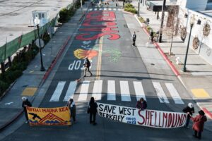
Tidal salt marshes are known as the most productive biological zones on earth. That our total amount of bay marsh has sharply dropped in modern times is one measure of the Bay’s lost natural productivity and health. In the early 1800s, this estuary comprised 1,207 square miles of tidal marsh and 80 square miles of intertidal mudflats, teeming with life. After humans altered the estuary with dikes, drainage, and landfill, these numbers dropped to 93 square miles of marsh and 47 square miles of mudflats. The Bay proper shrank in surface area by 37 percent. In 1960, citizen activists formed the Save San Francisco Bay Association and launched an ultimately successful crusade to bring these depredations to a halt.
As we finished up our picnic at Horseshoe Cove, California gulls and brown pelicans wheeled over open bay shallows where schools of anchovies and herring spread another repast. Below them, unseen, salmon, striped bass, halibut, and sturgeon plied the deeper waters. The flood tide was starting to build; the Bay’s hydraulics would soon reverse themselves and send a 4.8-knot current hurtling back through the Golden Gate. We packed up and reboarded our kayaks. Armed with a bit of local knowledge and a two dollar tide chart, we were ready to begin our return trip utilizing the forces that had initially daunted Ayala.
Riding astride the incoming current, we were soon hurtling past Crissy Field, a favorite locale for local windsurfers. We watched the city waterfront sweep by at increasing speed and were soon passing by the docks at Gas House Cove and Fisherman’s Wharf. On our way out at dawn, we had seen a dozen party boats, their rails crowded with anglers, trying their luck near Alcatraz during the ebb. Now those boats had scattered, some heading out beyond the Golden Gate to try for ocean bright salmon and rockfish.
We turned the corner at Treasure Island, heading for the South Bay. At 214 square miles, this is the largest of the Bay’s three lobes, as well as the most saline. That’s why the salt flats, for evaporating crystals from brine, have been located at its extreme south end for more than a century. Six gallons of water admitted to the settling ponds are eventually reduced to one pound of crude salt. Because of the salt, oysters—both native and introduced and farmed species’ have always grown better down in the South Bay than in the North Bay. It’s generally shallow down here, too, with depths ranging from 6 to 20 feet (except where dredging has occurred). The farther down the South Bay one travels, the less tidal current is felt. There’s much less in-and-out water movement. Instead, the water simply bulges up into the dome of a standing wave, in response to the hydraulic pressure, then drops when the pressure is removed.
Finally, we passed the shipping channel and commercial anchorage just south of Treasure Island and set a course directly for our starting point at Jack London Square in Oakland’s inner harbor. We docked there by early afternoon, tired but mightily pleased by our hours of sampling the pleasures of the Bay. Like the many boaters, boardsailers, anglers, ferry commuters, and bird watchers who flock here, we had also been caressed by cool breezes and impressed by the Bay’s power and expanse. Locals still must fight to preserve these resources, and work even harder to restore or enhance them. But there’s no doubt that San Francisco Bay remains one of the last, best places on earth. It’s not the earthly paradise that the Ohlone knew. It is no longer the pristine mystery that astonished Ayala. But the Bay is still beautiful and bountiful, ours to either love effectively or lose entirely.