.jpg)
History, we know, is everywhere. Yet certain spots in any landscape seem to be catchment points for traces of the past. Evidence of human strivings and events snags on them somehow, instance, there is the old Rancho Olompali, now one of the region’s least known, least visited, most neglected, and most charming state parks.
Olompali was the name of an aboriginal people and the name of the village where most of them lived. It lay at the foot of an impressive ridge north of Novato, on what was then the shore of San Pablo Bay. The word Olompali—accented on the first or the second syllable, depending on which modern Indians you ask—contains a root meaning “south” and a root meaning “village” or “people.” Perhaps 400 individuals, speakers of the Coast Miwok language, lived here.
In those days the site was waterfront property. The tide lapped at the base of the hill now called Burdell Mountain but known back then as Olompais. The water gave the Olompali people fish such as sturgeon, shellfish such as soft-shell clams, and tules, from which they built boats and with which they thatched their dwellings. The land gave them deer and other game, grass seeds and bulbs, the various plants used in basketry, and acorns from oaks of five species.
In most parts of the Bay Area, people scattered in summer to hunting, fishing, and seed-gathering camps. At Olompali, this dispersal was unnecessary. Everything needed for life was a short walk away, and so the village was occupied year-round. This easy living was typical of the North Bay, which is thought to have supported the densest native population north of the Rio Grande.

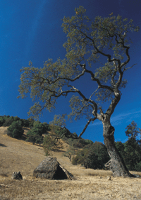
- A valley oak towers over a tule structure at the re-created Miwok village site. Photo by Jeff Caton.
There is some evidence that Olompali had special status among Coast Miwok villages. It was certainly a crossroads. A well-beaten trade route ran north and south along the Marin bay shore; another ran up nearby San Antonio Creek northwest toward the coast; the Bay itself was a highway. The chief’s house in this village—a kind of city hall—was apparently exceptionally large.
In 1974, a fascinating object came to light in the soil where that house once stood: a silver sixpence minted in the Tower of London during the reign of Queen Elizabeth I. Thoughts raced toward Sir Francis Drake and the Golden Hinde, which stopped for repairs somewhere along the Northern California coast in 1579. Could this be the sixpence the piratical captain had inserted into a “plate of brasse” and left on the shore of the land he called New Albion? Nobody knows. It’s unclear how or why Drake’s coin, presumably an important ceremonial object, would have found its way inland to Olompali. But if this village was a regionally important site, why not?
In the early 19th century, the Olompalis were inexorably drawn into the missions. Between 1814 and 1822, records show, some 250 members of the group were baptized. Typically, missionization marked the end of native villages. Olompali, however, did not die. It continued as an agricultural outpost or asistencia of Mission San Rafael Arcángel. After 1834, when the missions were shut down, control of the site and the large band still living there passed to an Indian leader named Huemox, baptized Camillo Ynitia.
Huemox/Ynitia was a survivor in a changing world. Successfully switching cultures, he built a house of adobe, thatched in the old way with tules, and adopted the life of a landholding Hispanic gentleman. He ran cattle, raised grapes and tree fruit and wheat, traded with the Russians at Fort Ross, and mingled with the Mexican and Anglo elite of the North Bay. With the help of his ally Mariano Vallejo, the Mexican military governor in Sonoma, Camillo secured formal title to the land, known thereafter as Rancho Olompali. A substantial Indian community continued there.
In 1848, the Americans took over. With more help from Vallejo, Ynitia surfed this second cultural wave and even emerged with his land title confirmed, a difficult thing for any Mexican-era owner and unheard of for an Indian grantee: Rancho Olompali was the sole deed to a California Indian that survived the change of regime. In 1852 Ynitia sold to the county assessor, James Black, retaining one corner, where he died in 1856. The remaining community scattered.
In 1863 Black gave the property to his daughter Mary when she married dentist Galen Burdell. The couple expanded the old adobe and encased it in siding. Galen set out to reclaim the tidelands of the lower Petaluma River. Placing barriers of pickets in the mud, he caused more silt to deposit and new land to form. It was the start of a process that would eventually push the bay shore back some four miles.
Burdell planted a large assortment of fruits and grape varieties, testing which would do best on this sunny, favorable site. Almost everything, even to the bananas, flourished. Mary Burdell collected many decorative Asian plants and laid out a formal garden in front of the home. Some of these plantings remain today, mixed with encroaching coast live oaks and California bays. Hired Chinese laborers built the handsome, mortarless stone walls still seen in the park.
In 1911, the Burdell children expanded the Victorian clapboard house into a mansion of 26 rooms. After passing through a number of hands (the young Grateful Dead were tenants in 1966 and held a number of free concerts here), the large home was severely damaged by fire in 1969. The blaze exposed the original Ynitia adobe at the end of one ruined wing.
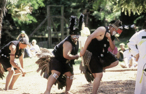
- Pomo dancers perform at a gathering at Olompali’s re-created Miwok village. Photo courtesty of California State Parks.
In 1977, the County of Marin and the State of California chipped in to buy the parcel for a state park. History was the draw; restoration was the promise. Progress on the latter has been slow. A protective outer building has been erected around the adobe; this shell reportedly leaks. A barn has been handsomely restored. Another 19th-century house nearby, intended to be a visitor center, is frozen in mid-remodel. But several dozen interpretive signs do a pretty good job of explaining who and what and how and when. Just uphill from the historic buildings, Miwok descendants have begun to build a model Indian village that may someday resemble the reconstituted settlement of Kule Loklo on Point Reyes. There are two individual dwellings or kotchas, one thatched with tule, the other with redwood bark. A larger structure nearby is not part of the authentic restoration.
Near the refurbished barn is the undeniable real thing, a “kitchen rock,” a boulder full of pockets where acorns were pounded. It’s at this homely spot that the past of Olompali seems most present, the voices of its old inhabitants most apparent.
The oak trees of Olompali, so important to the original inhabitants, remain one of the charms of the place. At the base and on the lower slopes grow large valley oaks, their branches extended over the grass like long gray tentacles. Among and around them appear the more compact blue oaks, a species you’d rather expect to find farther east, on Mount Diablo and throughout the inner Coast Range. You’ll also find a few Garry or Oregon oaks, which typically have straighter trunks and denser foliage. These species all hybridize, producing endless intermediate forms. This oak savanna landscape, naturally widespread in California, is in decline as older trees are cut or die and young trees are nibbled to death by grazing cattle or over-numerous deer. The state park here helps to protect a fine example of this once-extensive ecosystem.
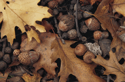
- The acorns of the black oak tree were highly prized by the Miwok for their superior flavor. Photo by Jeff Caton.
On up the escarpment of the mountain are dense stands of the deciduous black oak, with its sharp-lobed leaves and squat, nutritious acorns. These were another special wealth of Olompali; only in this northeast corner of Marin did Coast Miwok territory overlap the range of this tree, which Indians especially prized for the superior flavor of its acorns. Everywhere you’ll see the evergreen coast live oak, its leaves bellied like stiff little boats. The oak woodland includes as well handsome madrones, buckeyes, and bay trees, with hazelnut, toyons, snowberry, poison oak, and other familiar shrubs below.
It wasn’t just acorns that the Miwoks collected from this hillside. They used bay leaves to treat headaches, bay nuts as a spicy supplement to their diet, mashed-up buckeye fruit to stun fish in streams, and stinging nettle for cordage. They probably harvested wild rye, burning it in the fall to ease the winnowing. To a resident of Olompali, these hills would have been produce stand, drugstore, butcher shop, and bakery combined.
If we can’t see the land with the knowledgeable eyes of the Miwok, we can at least follow some of their footsteps on a 2.6-mile loop trail. Heading uphill from the parking lot, the path leads through oak savanna busy with oak-loving birds. On a November walk we saw acorn woodpeckers, oak titmice, Nuttall’s woodpeckers, red-breasted sapsuckers, and many others. On steeper slopes above, madrone and manzanita fleck the woods with orange and red; there’s one manzanita “bush” you could build a tree house in. At about the point where black oaks become the most numerous tree, the nonnative annual grasses underfoot give way to the blue-green, drooping bunches of native California fescue. Ferns take over in the draws. When the trees permit, you get glimpses of the valley of the Petaluma River, including Petaluma Marsh, the largest intact wetland on the shore of the San Francisco estuary. In winter it is a brown-tinged plain of tule, gleaming here and there where the sun catches sloughs and ponds.
On the northern half of the loop, the woods are denser and shadier and strikingly free of underbrush. This is a forest, as one hiker remarks, that you can see for the trees. Some trace this open character back to Indian burning, followed by a century of livestock grazing. But Marin County Open Space District naturalist David Hurlocker points to dead manzanita bushes as evidence that the tree canopy has closed only recently. Shade, he thinks, accounts for lack of undergrowth. The presence of bay trees is another factor, as their leaves exude a volatile oil that inhibits the growth of understory plants.
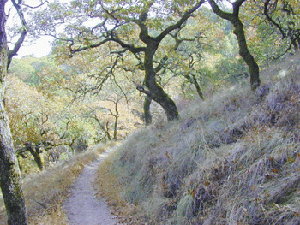
- The Mount Burdell Trail winds through oak woodland on the slopes aboveOlompali; in places, native bunchgrasses line the trail. Photo by Jane Huber.
As the trail begins to descend, you’ll notice how gentle the terrain becomes. You are walking on an ancient landslide, ripped from the steep top of the mountain and resting against the valley floor behind the village site. Stable now, the slide could easily start moving again if it were disturbed by the cuts and fills of urban development. This is exactly what has happened on another flank of Burdell Mountain, where unwise engineering recently woke up an ancient landslip. This unstable terrain tends to produce swales where water gathers. Outside the park to the south lies a wetland called Hidden Pond, which botanists say is Marin County’s only example of a true vernal pool.
From the midpoint of the loop a heavily switchbacked branch trail leads to the summit area, 3.3 miles away. Near the indistinct 1,588-foot high point of the ridge, one of the Burdells’ century-old hand-laid stone walls marks the park boundary. Beyond extends a large parcel belonging to the Marin County Open Space District.
Up here, near the Burdell summit, you’ll see boulders and outcrops of brownish andesite, a kind of lava. Unlike other peaks in Marin County, Burdell Mountain is built of volcanic rock, andesite lava, and broken bits of welded ash, or tuff. The hill lies at one edge of the Sonoma Volcanic Field, a zone in which young lavas bubbled up through the older and more regionally typical rocks of the Franciscan Formation. There is reportedly also some obsidian, valuable in Indian commerce.
Oaks, grasses, deer, marshes, obsidian: most everything that sustained the Olompali people in the Olompali place is still here. Thousands of people a day, traveling U.S. 101, pass within yards of this historic crossroads; few stop to visit. But for those with an ear for the land and its stories, Olompali State Historic Park has much to say.
GETTING THERE
The entrance for Olompali SHP is on southbound U.S. 101 about three miles north of Novato, and is accessible only from the southbound lanes. From points south, drive north on 101 about 2.5 miles to San Antonio Road; make a U-turn onto southbound 101 and return south to the plainly signed exit for the park. There is a $2 parking fee.
-300x221.jpg)
-300x182.jpg)
.jpg)
