Waves crash on the rocky shore, salt spray flings high into the air; pelicans and cormorants skim the water in single file; in spring whales spout offshore and wildflowers blanket the marine terrace. The stunning beauty of Salt Point State Park, about 90 miles north of San Francisco, is reason enough for a trip up the coast. Add an underwater reserve, spectacular rock formations, and an unusual white sand beach for an exceptional coast experience.
Salt Point State Park stretches for six miles along the rugged northern Sonoma coast, from Wildcat Creek to Horseshoe Cove, and its 6,000 acres cover diverse landscapes that range from the rocky intertidal at the shore to grasslands on the marine terrace to a pygmy forest of stunted cypress, Bishop pine, and redwoods on the ridge to the east.
Though the park is best known for its underwater reserve and splendid tide pools, to a geologist the main attraction is the incredibly beautiful rock forms exposed along the shore.
The landscape here is formed by two dominant geologic processes: plate tectonics and wave action. As such, it’s a showcase for two of the major forces shaping our region.
The San Andreas Fault, which forms the boundary between two of the earth’s great tectonic plates, lies just east of the park near the crest of the ridge. Along the fault, the Pacific Plate is sliding northwestward past the North American Plate. To the south the fault cuts across Bodega Head, then runs offshore and comes back on land near Fort Ross, 15 miles south of Salt Point. It goes out to sea again at Point Arena, about 50 miles to the north. Salt Point, then, lies west of the fault, on the Pacific Plate. This area, part of what’s called the Salinian Block, has been carried about 250 miles northward from its origin in Southern California. Fault movement has also tilted up and folded the rocks from their original near-horizontal position.
The rocks are much older than the landscape, some as much as 60 million years old, and formed under geologic conditions vastly different from today’s. In looking at the geology of the park, as elsewhere, you need to think in terms of two different time scales: the age of the rocks and the processes that formed them, and the present landscape and the processes that shape it today. Here, those processes couldn’t be more different.
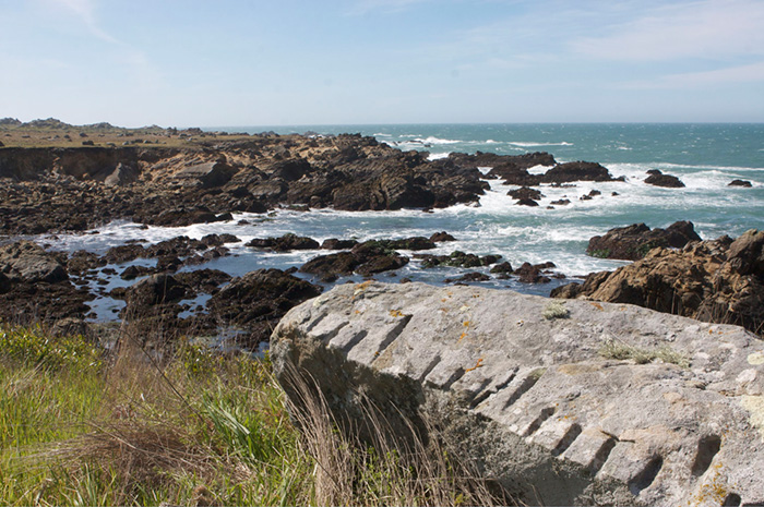
Take a walk along the Salt Point Trail from Gerstle Cove north to Stump Cove Beach, and you’ll see how the ocean is shaping this landscape. The coves form where rock is weaker–often along now-inactive faults–carved by pounding waves that wash away softer rock, leaving headlands of more resistant rock. These faults are much smaller than the great plate-bounding San Andreas Fault that lies inland. A small fault cuts through Stump Beach Cove, and another lies beneath the Gerstle Cove Visitor Center. Harder headland rocks can also eventually form sea stacks after waves carry off all the softer surrounding rock. Sea stacks, then, are a good marker of where the coast used to be.
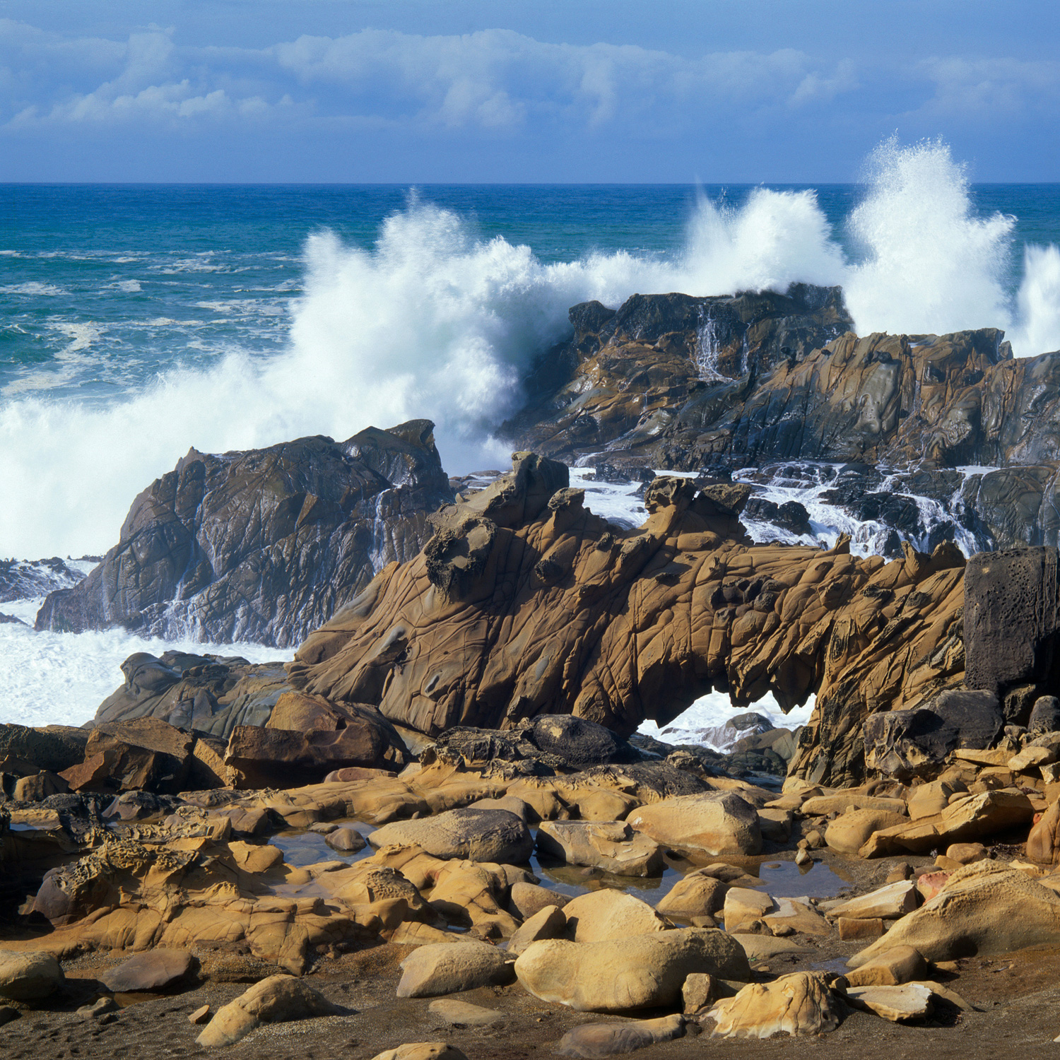
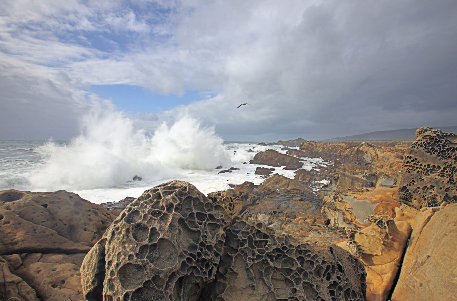
As you walk along the shore, you can feel the force of the crashing waves, powerful enough to fracture and break up the rock, forming caves and arches. But the visible waves are only part of the action: Sand and cobbles moved back and forth by the waves abrade and undercut the base of the cliff. As the edge of the land is eroded back, a wave-cut platform forms in the bedrock at sea level. Beautiful tide pools–inhabited by sea stars, anemones, snails, and other creatures–form where the waves have sculpted the rock. Where the waves are gentler, the platform may be covered by beach sand or cobbles.
Along tectonically active coasts like ours, those platforms don’t always stay underwater. In fact, the Salt Point Trail is on an uplifted marine terrace, formed at the shore about 80,000 years ago and since uplifted 30 to 40 feet by movement along the San Andreas Fault. Where uplift occurs repeatedly, you can look landward and see several levels of marine terraces, each progressively older and less distinct. The Pygmy Forest and coastal prairie sit on a much older terrace near the top of the ridge to the east, uplifted to about 900 feet.
The same processes at work eroding away coves and leaving headlands were at play thousands of years ago when the marine terrace you’re standing on was underwater, and now several fossil sea stacks dot the uplifted terrace along the trail. They were once craggy “islands” covered in seabirds, but they’re now hundreds of yards inland, buffeted not by waves but by wind–and the occasional quarrymen: In the 1800s, workers carved sandstone blocks from one of these sea stacks and shipped them to San Francisco and Mare Island. You can see the drill holes in the second sea stack along the trail north from Gerstle Cove. Many drilled blocks are still lying around on the terrace and in the cove.
Rocks aren’t the only thing people have harvested from Salt Point. The name itself comes from the Kashaya Pomo, the local Native Americans who gathered salt at the point from natural depressions above the high tide zone. Waves splash water into these “bowls,” which become lined with salt crystals as the salt water evaporates. The Kashaya traded the salt to inland tribes.
After Europeans arrived, timber and sandstone became the main exports. Beginning in 1853, lumber was shipped from Salt Point to San Francisco, and lumber schooners left Salt Point every two or three weeks until 1859. Gerstle Cove was known as a “doghole port,” a cove “too small for a dog to turn around in.” Rocks on either side of the cove still bear rusty bolts that anchored ships during loading. Lumber and sandstone blocks were loaded down chutes to the waiting ships. A model of such a chute is in the Fort Ross Visitor Center, a great stop on your way to or from Salt Point.
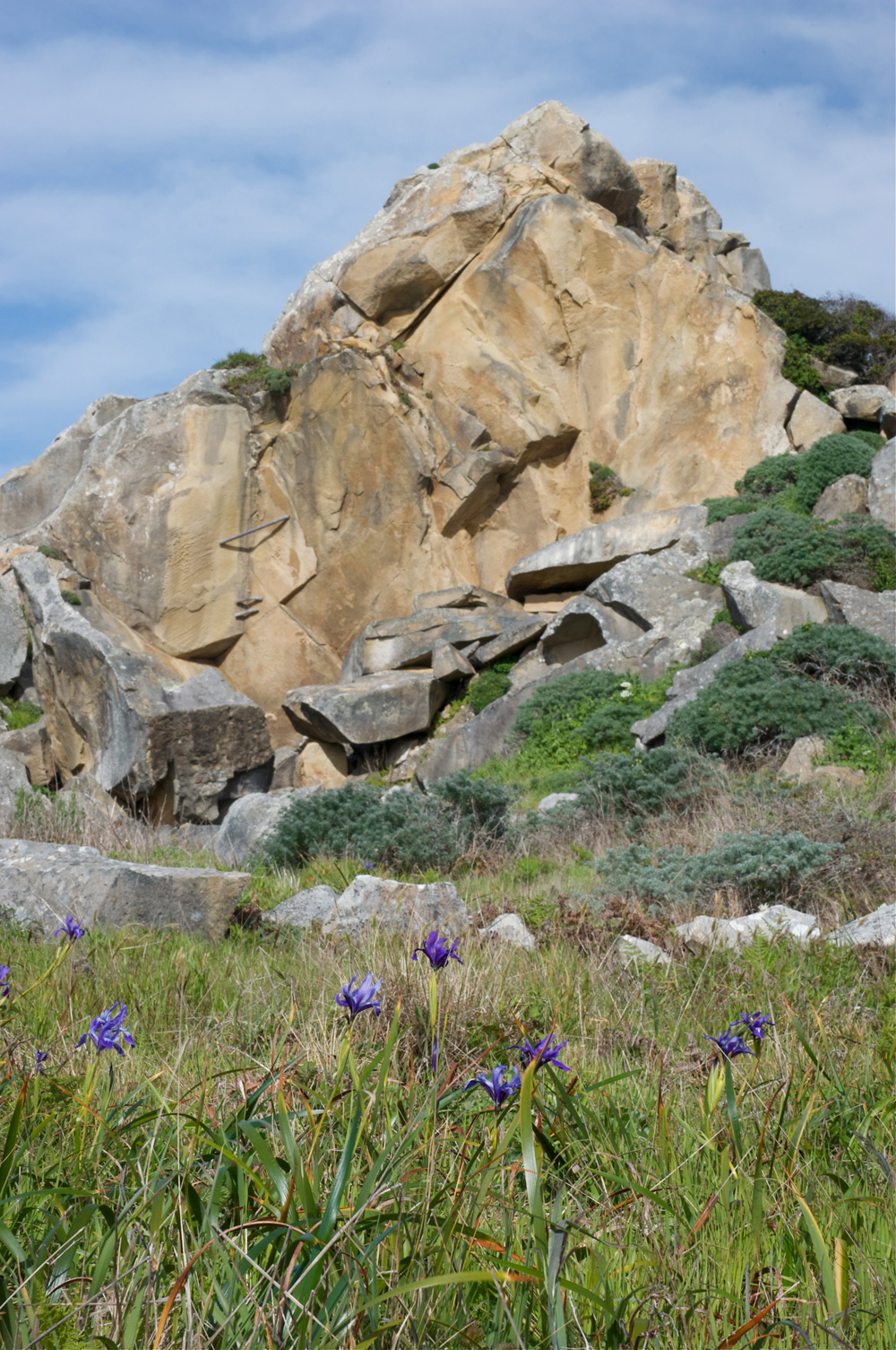
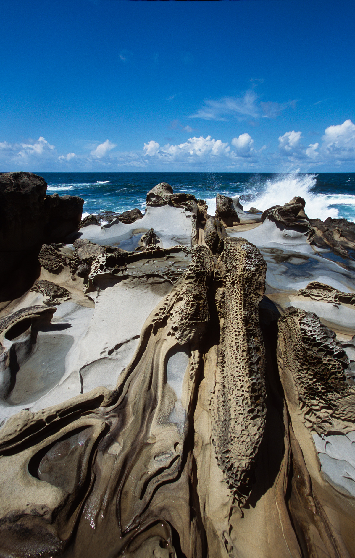
Today, it is the exceptional beauty of the rocks in the sea cliffs, rather than their commercial value, that draws visitors back to Salt Point again and again. Facing the sea, these rocks are full of tortured shapes, intricate tafoni fretwork (honey-comb weathering), and delicately shaded iron stains. You can best see these amazing rocks by scrambling down to the shore from the Salt Point Trail as it heads north from Gerstle Cove to Stump Beach. Stop and watch as the huge waves crash directly on these rocks, often sending up curtains and jets of white ocean spray. (Caution! Watch for sleeper waves. They can sweep you off the rocks even when the sea appears calm!)
Much of the beauty of these rocks, which are sandstone of the German Rancho Formation, comes from the way they are sculpted by the waves into knobs, bowls, and ribs. Weathering accents the patterns; lichens and iron oxides add subtle colors to the rocks. The intricate lacy patterns of tafoni are everywhere. It forms as salt spray interacts with the sand grains and loosens them.
The German Rancho Formation is made up mostly of coarse-grained sandstone deposited 40 to 60 million years ago in a submarine basin, called the Gualala Basin, which at that time lay about 250 miles south. These rocks, called turbidites, include some conglomerate, finer-grained sandstone, and shale or mudstone. They were deposited by turbidity flows, which are dense mixtures of water and sediment originally eroded off the land that flow down submarine canyons cut into the continental slope. Monterey Canyon is a present-day example.
As the turbidity current flows down the canyon, the coarsest sediment settles out first, with finer and finer material deposited later as the turbidity flow loses energy. So turbidites typically exhibit graded bedding, with cobbles or pebbles at the base of each flow, grading upward into sandstone and then fine-grained shale at the top of the deposit. As each new turbidity flow moves down the canyon, coarse conglomerate is deposited on top of the fine-grained sediment, giving the turbidites their strongly layered appearance. Sometimes such a large amount of sandy sediment flows down the canyon that the sediments do not form layers, but rather come to rest as massive deposits of sandstone. Both types of turbidites can be seen at Salt Point, the former at Stump Beach Cove, the latter below the Salt Point Trail.
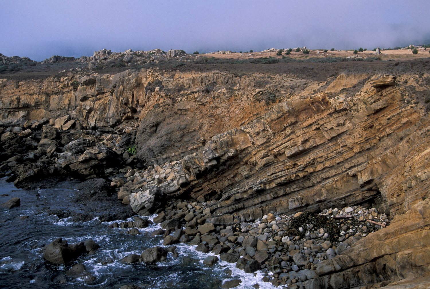
Between flow events, very fine sediment accumulates and if the time between flows is long enough, bottom-dwelling marine organisms may migrate into the sediment, only to be buried by the next event. You can see traces of their dwelling and feeding burrows and tracks in some of the mudstone. Other typical turbidite features also can be seen in the rocks where the sediment has been unevenly deposited or deformed, contributing to the rocks’ beautiful appearance.
The Salt Point Trail curves inland at Stump Beach Cove, which you can also reach by taking the stairs down from the parking area. Here the rocks look much different from those along the Salt Point Trail. Toward the beach, conglomerate lines the trail from the parking lot. It contains many different kinds of well-rounded cobbles, including granitic, volcanic, metamorphic, and sedimentary rocks. At the bottom of the stairs to the right of the trail, the rocks consist of layer upon layer of fine-grained mudstone turbidites. Walk to the beach and look back to see how the rock has been folded into a syncline (a downward fold resembling a U). In the head of the cove, a small fault has disrupted and crushed the rocks to a featureless mass. These rocks are more easily eroded and washed away by the waves, a process that has helped to form this cove. Constant landslides wear the cove back and prevent vegetation from gaining purchase on the slope.
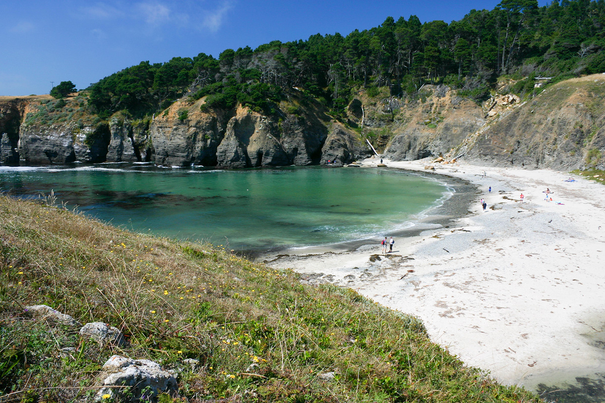
In contrast to the surrounding darker rocks, the sand on the beach looks almost white. Such light-colored sand is unusual for this coast. Look at the sand with a magnifying glass and you see that many of the grains are clear quartz. Where does this sand come from? Perhaps Miller Creek is bringing it from more quartz-rich bedrock upstream. This cove is the only one in the park with a large stream flowing into it, which may account for its unusual sandy beach.

Venture inland from the shore and you’ll find botanical marvels as well. The thick Bishop pine forest on both sides of Highway 1 is testament to a wildfire that burned 450 acres on both sides of the highway in November 1993. Bishop pine is a closed-cone pine that requires heat to open the cones, which usually takes a fire. After the 1993 fire, a great many seedling Bishop pines sprouted and now form a thick young forest. Competition is just starting to thin the trees out. (Locals report that on rare hot days when temperatures reach nearly 100 degrees, one can hear the cones pop open.)
Yet farther inland, take one of the trails up the ridge to the Pygmy Forest and the ridgetop prairie, or the six-mile loop from the trailhead at the south boundary of the park, up the ridge through the prairie and north to Fisk Mill Cove by way of Kruse Rhododendron State Reserve.
Salt Point’s exceptional beauty and interest are evidence of the interaction of fundamental geological processes at multiple time scales: weathering and erosion of an ancient coastal landscape in Southern California, as much as 60 million years ago, which formed the German Rancho turbidites; movement along the San Andreas Fault beginning about 20 to 25 million years ago, which carried the rocks to this location, crushed the softer rocks, folded the more resistant ones, and uplifted them; and, in the here and now, weathering and wave attack that have carved wave-cut platforms, caves, coves, and tafoni.
All those come together to create six miles of incomparable coastline rich in history and yet still changing all the time.
-300x221.jpg)