.jpg)
On November 20, 2010, Mark McDonald had enough to do without crazy tourists running amok on his mountain. As Mount Hamilton’s lone police officer, he was charged with ensuring the safety of the visitors and astronomers at Lick Observatory, perched high in the hills east of San Jose. This day was especially busy, as a freak snowstorm had blown in and caused the whole mountain to shut down in a wintery, slushy mess.
McDonald was busy clearing out nonessential personnel when he saw two women wandering around outside their Honda Accord on the roadside in a near whiteout, holding some kind of metal rod with silver crossbars up in the air. Visibility was about 50 feet and the snowfall mixed liberally with rain and heavy fog.
McDonald tried to shoo them away, but they politely refused to go anywhere. They and their team of hawk trackers had been following a juvenile redtail named Bonnie for almost a week, and they were damned if they would give up because of a little snow.
The women were volunteers with the Golden Gate Raptor Observatory (GGRO), a research center nestled in the Marin Headlands that over some 25 years has grown into a partnership between professional scientists and fiercely loyal volunteers who count, band, and track local raptors.
A program of the Golden Gate National Parks Conservancy and Golden Gate National Recreation Area, GGRO is divided into three separate but related research efforts, all based out of an aging military building at Fort Cronkhite in the Marin Headlands. First, there are the hawk watch volunteers stationed atop Hawk Hill, just north of the Golden Gate; their task is to spot, identify, and count all raptors that pass nearby. Second are the banders, a smaller team of people who hide in tiny blinds for hours waiting to band raptors that get caught in baited nets. But the telemetry team sees the real action–fast-paced work best described as a cross between a David Attenborough documentary and an episode of 24.
GGRO’s telemetry program began in November 1990 with the idea that it wasn’t enough to count or band birds. Rather, scientists wanted a more complete picture of raptor movements in between the relatively rare occasions a banded bird might be found and reported. So they turned to radio telemetry, one of the favorite tools of modern wildlife research.

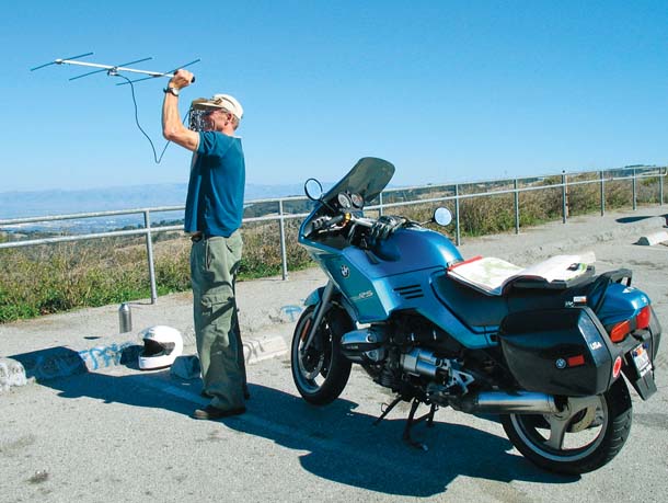
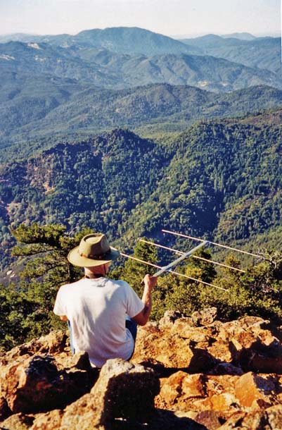
- Bill James tracking from his motorcycle along Skyline Boulevard in San Mateo County. Photo courtesy Bill James.
Telemetry starts with a small, lightweight radio transponder attached to an animal, which is then set loose. The device sends out a signal at a specific frequency received the same way that your car receives a radio program from a tower. But unlike a radio tower, wildlife is almost always on the move.
Since that first year, the telemetry team has tracked a total of 56 raptors of five different species, going as far north as Redding and as far south as the Mexican border.
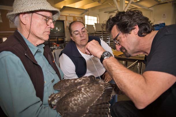
- Larry Beard affixes a transmitter to the tail feather of Athena while GGRO Research Director Buzz Hull holds her and volunteer tracking coordinator Lynn Jesus looks on. Photo by David Jesus, DavidJesus-NaturePhotography.com.
“I don’t know of anybody else who is trying to do long-range migration tracking with volunteers,” says Buzz Hull, research director for the GGRO. “Radio tracking fills in some really interesting gaps that the other methods we use don’t adequately assess. We don’t really get an idea from anything else that we do about the exact path a bird takes and its daily routines.”
But getting the data isn’t easy. The trackers have slept in dirty motels, in trucks, even on the cold ground and have occasionally attracted the attention of the police. Over the years they have accumulated countless keys that open hundreds of locked gates.
“The bird is a big part of it. But also it’s getting out to all these different places that are off the beaten track,” says longtime tracker Bill James. “You get to see California like you’ve never seen it before.”
I came to GGRO during the fall 2010 migration season early on a Saturday morning in November to meet with Lynn Jesus–organizer, heart, soul, and “mother hen” of the telemetry program.
Jesus, chipper and self-effacing, started volunteering two decades ago as a hawk watcher. When the telemetry program started, she and her husband wanted to answer their burning question: “Where are these raptors going?” Now, she puts a lot of time into the program every fall, but she wouldn’t have it any other way: “Some people play golf, I do this.”
My partner for the chase will be Bill James, a slim, affable, retired electrical engineer who has been chasing raptors for 18 years. If the banding team catches a trackable bird, we’ll have about an hour’s notice to get in position. In that hour, the bird is brought to headquarters, fitted with a transmitter, and taken to some exposed spot for release. After that, if you aren’t ready, you may never see the bird (or the team) again. We have a little breakfast, pack our gear in James’s truck, and sit down to wait for a bird. And wait. And wait.
But the team can’t do a thing until a bird is netted, and as the hours tick by, it dawns on us that today is not our day. By lunchtime, the team members are twitchy and decide to take a practice run. James and I take off for the top of Yerba Buena Island, while another pair makes for San Bruno Mountain. The third car tapes a radio transmitter to a stick and becomes “the bird.”
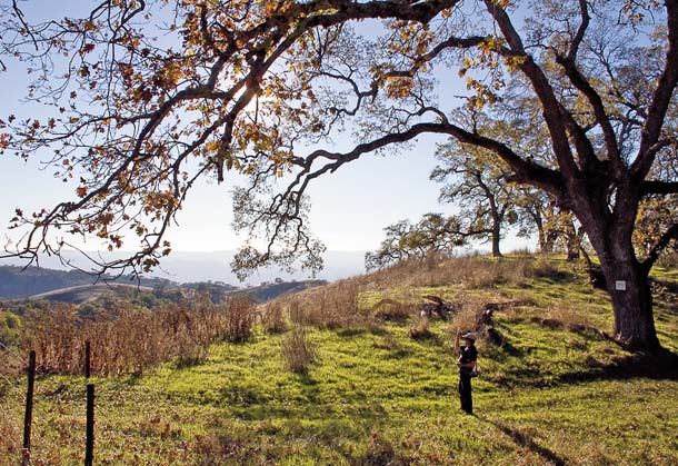
- Larry Beard tracking Bonnie under a large oak tree near Henry W. Coe State Park east of Morgan Hill. Photo by David Wimpfheimer, calnaturalist.com.
As the “bird” moves, each search team determines a line between itself and the bird. The lines’ intersection is the bird’s likely location. Using ancient pagers and complicated codes, the teams report back to Jesus, who plots the bird on a map at her home command center. As the bird moves, a third search team tries to anticipate its intent and sets up on another high point to follow it. It’s a little like a leapfrog relay race that may span 500 miles.
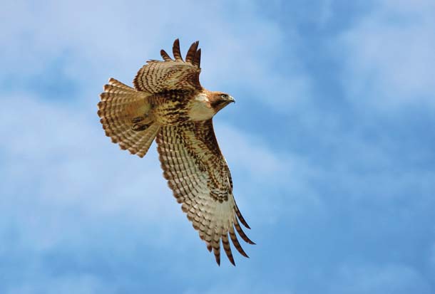
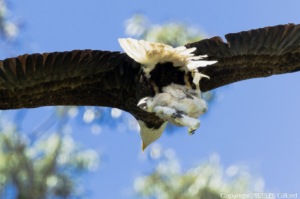
- A redtail hawk called Patch, with visible GGRO leg band, flies through San Francisco. Photo by Walter Kitundu, birdlightwind.com.
The first bird that GGRO tracked, in 1990, was a redtail called Adam (like in the Bible). He led three teams of trackers through the Salinas Valley to Soledad, marking the first time anyone had gathered continuous location data from a Bay Area raptor.
Since then, various birds have taken teams up and down the state. James’s favorite was a broad-winged hawk named Zoe in 1994. As soon as it was released it made a beeline south. “[It] just took off,” says James. “And from then on, we were always behind it.” The bird led them from Pacheco Pass, through the central Coast Ranges, down over Mulholland Drive in Los Angeles, to Tecate Peak on the Mexico border. “On Tecate Peak, we just watched it go right by us. It went on down to Mexico and that was it.”
Hull says this was the first and only time anyone had followed a broad-winged hawk–an uncommon bird here–on a West Coast migration, and the team was loath to leave it at the border: “They called me and said ‘Buzz, Buzz, it went to Mexico! Can we go?'”
On the other end of the spectrum was Waldo, who led trackers all the way to Larkspur, where a family hand-fed her store-bought meat.
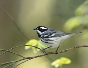
It is another four days of waiting before volunteers catch a trackable bird: “Athena,” a juvenile female redtail, weighing about two pounds ten ounces–not exactly trim.
“She was a … bigger bird,” as Jesus politely puts it. In truth, she is what Jesus calls a “couch potato” bird.
Hull says one of the most important findings to come out of the GGRO over the decades is that there seem to be two surges of redtail hawks during the fall. First come birds that tend to stay local. Next is a surge of birds traveling relatively long distances. Interestingly, genetic tests show the two groups are distinct populations–one from Central California and the other from the Great Basin. It’s the first such genetic two-pronged bird migration to be statistically confirmed.
The team bands Athena and takes her to Hawk Hill for release. Longtime chaser Larry Beard, by day a San Francisco Opera set builder, removes Athena, looking thoroughly unamused, from her protective container. The teams are in place–one nearby, one in the Richmond hills, and one on San Bruno Mountain. While a cluster of tourists whip out cell phones for pictures, Beard releases Athena, who immediately banks south and then east, and the chase begins.
“The bird is in charge. We are not in charge anymore,” says Jesus, and then smiles.
Athena roosts nearby for the night. At seven the next morning, Bill James is on hand at Fort Cronkhite to track her as soon as she wakes up. Across the Bay, on San Pablo Ridge in the East Bay Hills, UC Santa Cruz biologist Phil Capitolo has a view–and tracking coverage–of both San Francisco and Marin and will be the first to know if Athena makes a break for it.
Which she does. At 7:50 James has a bead on Athena, but minutes later she’s gone.
- GGRO volunteer Jim Shea scanning for a signal from the top of Mount St. Helena in Napa County. Photo courtesy Jim Shea.
Years ago, it was assumed that raptors loathe flying over large bodies of water. However, the telemetry team has shown again and again that hawks may cross the Bay multiple times daily. Capitolo pages that Athena’s moving south–headed across the Gate on the ocean side.
“The minute she crosses, everybody’s on the move,” says Jesus, who is coordinating the effort from headquarters.
If Athena hugs the shoreline, she may be out of sight for Capitolo from his East Bay perch and could lose us. So James must get in front of her, in case she finds a hiding place or makes a run for Mexico.
James crosses the bridge in sluggish morning traffic and soon learns Athena is still headed south, so he beelines for Interstate 280. “Bill James doesn’t sit anywhere for long,” says Jesus. “He’s flying, moving to keep up with the bird.”
In 2004, James stopped for lunch in Napa while a bird named Ozzie was on the move. Ten minutes later Ozzie was nowhere to be found and that was the last anybody heard of him except for a faint blip from somewhere near Redding. James isn’t about to let that happen again. By 9:45 he has a signal from the top of Skyline Boulevard, overlooking Half Moon Bay. The other teams lose her as she continues south.
Then Athena just stops. By about 10:30, she’s found a nice spot just outside Half Moon Bay. The team readjusts and gets ready for the next chase, but it never comes. Months later, Athena is still there, apparently snacking on plentiful mice and voles.
“She got across the Gate and looked for the beach party,” says Jesus, shaking her head.
The team watches Athena for a few days but it’s clear she has settled in. Thankfully, it’s not long before they get a second call. Bonnie, another youngish female redtail, has been caught just inland from Hawk Hill.
Like Athena, Bonnie is released in the afternoon and finds a spot nearby to call it a night. The next morning, chasers in place, she gets up late, stretches her wings, and goes for a couple of short flights to Tennessee Valley. But sometime in the late morning Bonnie slips past her trackers and heads south over the Gate.
“She snuck by us,” says a note in the tracking log. “The chase is on.”
The team scrambles as Bonnie appears to follow Athena’s lead. Bonnie spends the night near Half Moon Bay and there is momentary concern that she will stay put as well.
But the next day she’s in Pescadero and then flying south to the Forest of Nisene Marks State Park, near Santa Cruz. She’s up at the crack of 11 the following morning and continues south in blisteringly hot weather. One team on Fremont Peak has a good signal all day, but the others lose her somewhere in the southern Santa Cruz Mountains, thanks to a closed private road. They have no key for the gate, and they lose Bonnie without a cross bearing. The next day, she appears intermittently, drifting east into the Diablo Range. It’s rough country with few roads and trackers fear they might be losing Bonnie.
So one car drives to the 4,000-foot summit of Mount Hamilton east of San Jose and gets a faint signal to the east. The following day turns stormy and the snow starts. Volunteer Barbara Westree gets signals from somewhere to the south, near Henry W. Coe State Park, where roads are far too sparse and rugged to get a better angle. With the bewildered cop looking on, the team sticks it out until mid-afternoon and then retreats down the mountain. The sixth and last day of the chase brings a few more signals from Bonnie but then they just stop.
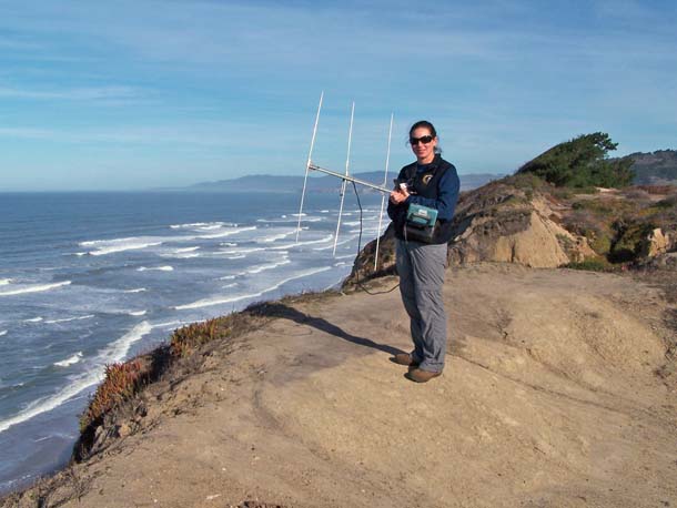
- Golden Gate Raptor Observatory intern Anastasia Ennis tracking a redtail called Athena near Martin’s Beach in Half Moon Bay. Photo courtesy Anastasia Ennis.
In late January, I meet up with Phil Capitolo, in the hopes of seeing an old feathered friend, though I don’t know if I’m delighted or chagrined. On one hand, it’s nice to visit a bird I saw take to the sky two months before. On the other, nobody likes a couch potato.
Sure enough, from the crest of a hill near Half Moon Bay, we hear Athena’s strong beep, beep, beep. We can’t see her, but based on the position he’s holding the antenna in and the strength of the signal, Capitolo can surmise that she’s perched, which means she’s still alive.
Standing out by the side of the road, Capitolo tells of his first bird (called Francisco), in 1992, which led the teams 40 to 50 miles a day, all the way to the Eel River in Mendocino County. They lost it, only to have it reappear weeks later back in the Bay Area. Hull says that had they simply relied on band reports, they would never have known of its long wanderings between two local sightings.
But radio telemetry, a crucial tool for generations of biologists, is now being replaced by GPS tags and satellite trackers that record continuous location data without teams struggling to stay in range. These new tools are still expensive and many are too heavy for birds, but already they’re allowing scientists to track animals from the comfort of the lab.
“There was a [GPS-tagged] peregrine on the East Coast that was found to move over 900 miles in one day. And that’s something that we could never find the way we are doing it,” Hull says. But he adds that a GPS is blind to other important things, like what kind of tree a bird roosts in and what habitat it uses.
Bill James admits that when GPS arrives at GGRO, there may not be any need for teams of volunteers barreling around California. The volunteers at GGRO are drawn as much by the camaraderie and adventure as the science. It’s the waiting and the buildup, the release and the pursuit that may take you to all corners of the state or just to your own backyard.
“What brings people back year after year is the thrill of the chase. When the bird is on the move and you’ve got three teams in the field all working together to keep up with it,” he says, “it’s days like that that just get everybody excited.”
He stops. The receiver lets out another set of beeps. Looks like she’s moving again.