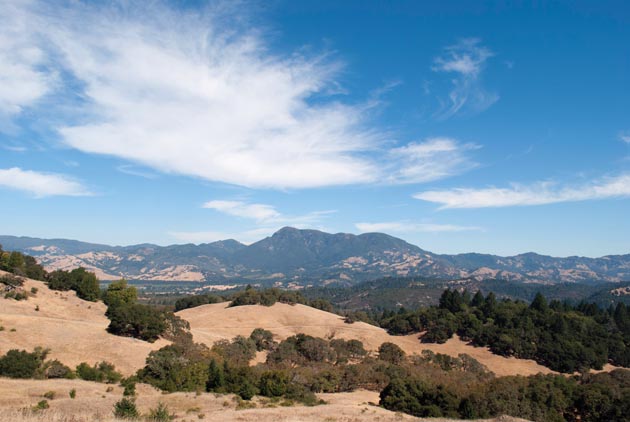
It’s July 2010, at state-of-the-art Dwight Center for Conservation Science at Pepperwood Preserve in the Mayacamas range east of Santa Rosa. The place is surrounded by some 3,000 acres of iconic Bay Area Coast Range habitat: sunny skies, untrammeled oak woodlands, gorgeous views. Inside, 23 palpably excited scientists introduce themselves and rattle off their disciplines: climate change modeler, spatial ecologist, physicist, soil physicist, ecologist focused on global carbon cycling and probabilistic vegetation modeling. Uh oh. Is this conference going to be all about graphs, equations, and incomprehensible hypotheses presented with wild enthusiasm? (Yes.) A fire ecologist announces himself as “Discoverer of the Previously Unknown.” Everybody laughs.
“The whole town’s here to paint the fence,” says Lorrie Flint, a hydrologist from the U.S. Geological Survey. “And David’s our Tom Sawyer.” The tall, slim master of ceremonies is Dr. David Ackerly, professor of integrative biology at UC Berkeley. In buoyant terms Ackerly dubs the assembly a “Mensa-style” group and calls on everyone to help figure out what climate change is doing to nature here in the Bay Area, with eyes on the prize beyond. Their goal is to combine the expertise from all of these disciplines to develop a climate change adaptation framework that can actually be used by resource managers.
By the following year, the group had been winnowed down to a still-large corps of scientists christened the Terrestrial Biodiversity Climate Change Collaborative (TBC3). Since then the group, with funding from the Gordon and Betty Moore Foundation, has produced all manner of work that has deepened, widened, and illuminated our knowledge of what’s going on out there, a kind of living map that encompasses not only the tangible signposts of earth, rock, vegetation, and wildlife, but also the interpenetrating elements of sunlight and water in all its myriad forms.
To Keep on Keeping on
It’s not “news” to Bay Nature readers that climate change is in the process of giving a serious thwack to living systems. But what’s less well understood is how plants and animals and the habitats they inhabit are moving—and being altered—in response to changing temperature and precipitation patterns. The Pepperwood oaks, branches reaching like so many grandmothers‘ arms, may not be here in the future. When will they go, where will they go, and what might be here in their place? Moreover, even if these species are able to move, they won’t all move in lockstep, so the evolutionary relationships among them are likely to be disrupted. How will that further impact the landscape? And how will that affect the way we manage the areas we have protected and the way we target other areas for protection going forward?
There are several big hurdles to figuring out these issues. As academia requires, these scientists are all specialists, virtuosos of the narrow focus. One analyzes fog, another plants, another landscape connectivity. But nature, of course, is made up of all those parts, and more, and functions through interaction. So to understand the whole, the group will need to integrate their individual approaches—not easily done. Further, climate models provided by the authoritative Intergovernmental Panel on Climate Change (IPCC) show future temperature and precipitation patterns, but at enormous scales. Natural interactions do add up to big signatures, but for grape growers, for farmers, for ranchers, for water district supervisors—for everyday people who need to make decisions about the landscape—what happens on the small scale is much more important. The group will therefore “downscale” climate models to the level at which we actually live.
Multitudes and Multivariates
Looking up close and personal at California means taking into account both our Mediterranean climate—warm, dry summers and cool, wet winters—and our beautifully varied landscape of hills, mountains, rivers, creeks, and marshlands, with the myriad microclimates this topographic diversity produces. As species are having their habitats pulled out from underneath them, the good news is that our heterogeneous landscape means a cooler or wetter spot might exist for a species just a bit to the left or the right or up or down from where it is now. Where exactly those climate refugia are likely to emerge is a big question for conservation, since we need to make sure we protect—and connect—these places, to give time and space to plants and animals to rejigger their relationships and adapt. But where will they be? Even as the ensuing years of nose-to-the-grindstone research and analysis go forward, TBC3 retains a palpable sense of questioning, of poring over the complexities and dynamics of nature with an attitude, yes, of discovering the previously unknown.
Solid as a Rock
“As much as we are all interested in the biological effects of this, there was a broad consensus to start with the abiotic,” explains Dr. Lisa Micheli, referring to the primary products delivered by TBC3 thus far. The star so far is a set of “high-resolution climate hydrology scenarios” for the San Francisco Bay Area. Micheli is the executive director of Pepperwood Preserve, the co-leader of TBC3 with Dr. Ackerly, and more. She is both a scientist contributing to the research and a land manager keenly interested in applying it to the landscape for which she is responsible. Micheli is a geomorphologist, so while strolling the grounds of Pepperwood, she is likely to point out a rift in the terrain and tell you how old it is. By “abiotic” she’s mostly talking hydrology—that is, how water moves through the precipitation cycle and also through the landscape. Other big abiotic factors include soil and sunlight, and putting those two together with water, we arrive at the piece of the puzzle that has absorbed these scientists for four years, “the climatic water deficit.” It turns out to be a central signal in understanding the effects of climate change on biodiversity.
I’m Thirsty
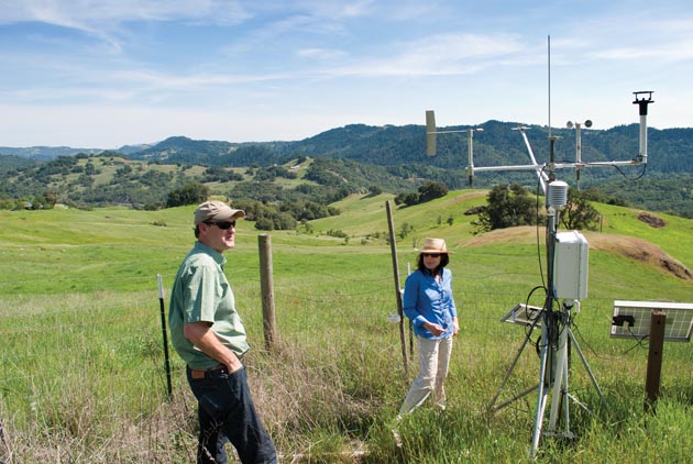
Lorrie and Alan Flint are U.S. Geological Survey scientists. Married for 38 years, they’ve worked together nearly as long, and they don’t so much finish each other’s sentences as toss the conversational baton back and forth between them. The Flints developed a model that is exciting because it produces a value representing the amount of water available for use by a plant, discernible not by making big generalizations from space, but by measuring the capacity of the soil to hold water, right where the plant grows, and also measuring the amount of that water the atmosphere sucks away from it (evapotranspiration). Because of this tension between the soil’s ability to hold water and the atmosphere’s ability to evaporate it, even if we get more rain in the future (the IPCC models differ on this), we will still experience more drought due to the increased heat in the system, which will evaporate the water at a higher rate. The plant winds up with a debt—the amount of water it would have used for growth and reproduction had the water been available.
“Instead of a blanket look at the Mediterannean climate,” Lorrie says, “we can characterize [the landscape] right down to the level of creeks at Pepperwood.” At one meeting she demonstrated by showing graphs of the lower Laguna de Santa Rosa and Franz Creek. Pepperwood contains the headwaters for both. “They have different soil and storage capacities,” she notes. “The Laguna can hold water longer and thus has less accumulated deficit. Franz Creek gets more rain but experiences a longer deficit anyway.” Flint counsels land managers to “know your watershed! You may not have to worry so much about some parts of your lands.” She emphasizes that the models don’t tell managers exactly what will happen on their land, but present a framework within which they can ask themselves if it will make sense in the future to continue to manage their land as they are now.
On the Watchtower
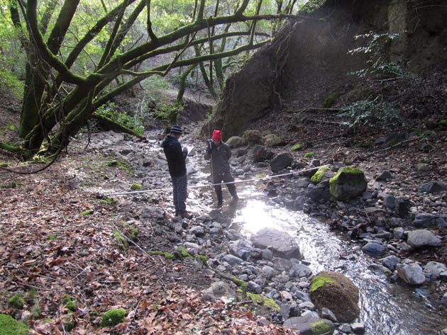
The climatic water deficit at Pepperwood is measured partly by soil probes the Flints have strategically placed across the landscape. The long metal spears stuck in the ground are joined by weather stations, fog sensors, and wildlife cameras arrayed to capture animal movement. In addition, David Ackerly has demarcated 50 plots of oak trees to capture physiological and life-cycle responses over time. All these data points collated together will create a “biophysical knowledge base” from which to track how species respond to climate change as it unfolds. Micheli and Ackerly will watch keenly to discern where and when a vegetation “transition” might occur—for example, where Pepperwood’s oaks may be at the edge of their range and so more likely to disappear from it as temperatures ratchet higher and soils get drier. Many other complexities are at play, and one sunny spring day I tagged along while Ackerly showed a group of plant ecologist colleagues “some crazy hybrids.”
These are people obsessed with the minutiae of green growing things, so we don’t move very far very fast. Micheli explains that oaks are rampant interbreeders and the genetic resilience of hybrids poses an interesting question vis-à-vis-climate change. The hybrids seem to capitalize on the best of two sets of genes, but as ecology has unfolded thus far, their flashy dominance is short term. Over the long haul it has been the purebreds that have persisted, based partly on the power of conserved traits, the genetic raw materials that old lineages have passed on for millennia. But with climate change, the evident flexibility of hybrids to adapt to novel conditions in relatively short order may trump other survival strategies.
The group stops. “I love this spot,” says Ackerly. Appreciative growls concur but I’m flummoxed. It’s all beautiful to me. “You see these grasses?” says a postdoc along for the tour. “These are native perennials. This is a snapshot of pre-Mission California, before cattle grazing and imported European grasses disturbed the environment.” He draws my attention to the delicately hued tips of purple needlegrass (Stipa pulchra, the state grass of California). Its long root systems hold water in the soil, which creates drought resilience and specifically supports the oak forest around us, keeping oak seedlings hydrated. We are looking at an ancient relationship that’s still functioning.
Bringing Adaptation Home
Change on this landscape is not new, after all. The question going forward is, how well will the ecosystem continue to function, and to what purpose? In the end, it is people who will have to adapt to the resulting changes. From its inception, TBC3 has been about developing cutting-edge science not just for its own sake, but with the express purpose of making it useful for people. Micheli sees her task is “to not just give land managers this climate future information, but to work with them to integrate it in actual places.” On this score, conversations are just beginning.
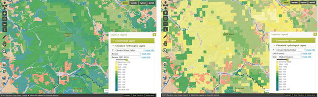
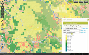
In November 2013, a subset of the TBC3 group presented initial findings to local North Bay land managers. “Today we are here to get feedback,” Ackerly began. “Things are fresh out of the oven here.” Offerings include high-resolution data sets from the past 100 years that make it possible to project scenarios for the next century, given a doubling of atmospheric CO2. Dr. Stuart Weiss, of the Menlo Park–based Creekside Center for Earth Observation, presented his integration of the Flints’ climatic water deficit data into a comprehensive interactive mapping model called the Conservation Lands Network (CLN). What in other hands might have remained academic models are thus provided through TBC3 for virtually anyone who wants to use them to help grapple with climate change impacts on the ground.
Pepperwood itself, all wired up with probes, sensors, and transects, has become a “sentinel site” through which regional climate change impacts can be glimpsed in microcosm. Micheli envisions a Bay Area network of such sites, including related work being done by uc Berkeley and the Nature Conservancy on Mount Hamilton and Stanford researchers at Jasper Ridge Preserve. At the rollout to land managers, participants take mini field trips to various habitats on Pepperwood. I follow a group led by Stu Weiss. Weiss points out a clump of invasive grass; a rancher opines that he loves the stuff because it’s rich fodder for his cattle. A conversation ensues about the juggling act of applying generalities on specific landscapes. Although TBC3 has provided new tools for grappling with nature, the road map for what lies ahead is of necessity a collaborative work-in-progress. Rich Burns, field manager of the Ukiah office of the Bureau of Land Management, tells me, “Lisa’s group just stands out as a community-based tie-in to academia that you can’t find in many places. Pepperwood and TBC3 are an incubator, bringing people together and guiding creative thinking.” He pauses and adds, “I guess I’d call that leadership.”
You can find a subset of TBC3 findings on the Climate Commons, hosted by the California Landscape Conservation Cooperative: http://ow.ly/xNzrR. The
Conservation Lands Network map-based tool is at bayarealands.org/explorer/.
-300x231.jpg)