.jpg)
“THIS OLD FAITHFUL GEYSER OF CALIFORNIA IS ONE OF THE MOST RARE PHENOMENA IN A BEAUTIFUL SETTING AT THE FOOTHILLS OF MT. ST. HELENA,” the sign reads.
The marker is antique, its laminate buckled and cracked by the elements. It is one of the many placards that seek to explain and glorify our own Old Faithful, a tourist attraction since the late 1910s.
“THOUGH, IT APPEARS AS IF NOTHING IS THERE OUT OF THE QUIETNESS AND SERENITY COMES SURPRISE AND IS SAID TO BE STRANGER THAN FICTION,” the sign continues.
It is a pleasantly warm winter Tuesday, a slow day for the Wine Country tourist trade but a fine time to linger in the strangely serene, bamboo-protected glade that caches the geyser. An elderly woman in running shoes brandishes a video recorder, poised for the eruption.
“REMEMBER,” the sign insists, “YOU ARE NOT WAITING, YOU ARE WATCHING FOR A PHENOMENA TO TAKE PLACE AT ANY MOMENT.”
Meanwhile, far below our feet—a mile deep, or two miles; no one really knows—water has percolated into a natural underground reservoir, a layer of fractured rock that has been heated by magma farther underground. As the water nears the heat source, it becomes increasingly hot and decreasingly dense, and it begins to rise. It’s a natural convection system, not unlike the teakettle on your stove. At some point the water reaches a critical threshold and bursts into a mixture of liquid and steam, now ascending rapidly through fractures in the layers of rock and soil. It breaches the surface of the earth at just about 350 degrees Fahrenheit, soaring 40 feet into the sky in a pulsating burst that mimics the heart-pumped bleeding of a critical wound. After a minute or two, the geyser announces its departure as it did its arrival, with a chuffing gurgle.
“Got it,” says the elderly woman, and she and her husband are gone, making a beeline for the parking lot.

- Photo by PG&E/Lewis Stewart.
Water that percolates underground heats up after it reaches the layer of fractured rock (graywacke) that has been heated by contact with an ancient source of magma below. The heated water then rises back to the surface. emerging in hot springs, in geysers, or as steam in fumaroles. The separate, but similar, underground “reservoir” that feeds steam to The Geyser’s geothermal plants, several miles to the northeast of Calistoga’s Old Faithful, is fed now by imported wastewater rather than by percolating groundwater. Illustration by Paula Nelsen.
Stewards of the geyser just north of Calistoga proclaim it one of only three in the world that are “faithful,” or generally regular in their spewing. This Old Faithful is another oddity in a region that seems to brim with them. Here, where Napa, Sonoma, and Lake Counties come together, you will find the most productive geothermal field in the world; bygone mines of silver, gold and cinnabar; earth’s largest petrified trees; countless mineral springs, hot and cold; and world-famous vineyards.
All of them reside in the arena of light. But each has its origin far below the crust, in the volatile geology and volcanism of the California coast…
A few years ago, I bought a series of 20 cardboard posters at a yard sale in Calistoga. They were produced by USGS, and as a group they are called the Atlas of Volcanic Phenomena. I coveted these posters for their retro-cool design and three-dimensional graphics, more than for the detailed copy on ash flows or magmatic differentiation. But Sheet 15 of the Atlas, I now notice, offers a beautifully succinct description and delineation of geysers, fumaroles, and hot springs. Here in the North Bay, we have all three.
Geysers shoot heated water and vapor vertically from the ground in periodic blasts. Fumaroles produce a constant cloud of vapor. Hot springs leave the earth in a steady, liquid trickle. They differ substantially in appearance but trace their origins to a single source: surface water that percolates downward over time and is heated by an unusually shallow magma chamber—in our case, one that exists (or possibly once did but no longer does, as some believe) 5 or 10 miles below the surface of modern-day Lake County. This magma chamber heats the adjacent rock, which in turns gets the water in the rock to boiling.
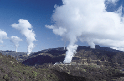
Exhibit A is the area known as The Geysers, in the Mayacamas Mountains bordered by Healdsburg and Geyserville to the west and Middletown and Cobb to the east. This is the world’s most productive steam field.
The Geysers are a rarity in that they produce nearly all steam and no liquid . . . and no geysers, despite the name. That, according to Calpine Corporation geologists Mitch Stark and Charlene Wardlow, is largely explained by two fault lines—the Mercuryville to the southwest and the Collayomi to the northeast—that act as hard barriers around the subterranean reservoir. Much of the rock in the faults is serpentinite, a relatively pliable rock that can get squeezed into gaps and pores in the crust. It acts as a sealant, like plumber’s putty between pieces of galvanized pipe.
Above the reservoir, meanwhile, are layers of serpentinite and argillite, a type of clay. The overall effect is a closed system that cuts off the influx of groundwater and reduces pressure in the field, allowing for almost pure vapor. (With greater pressure, liquid water that had not yet heated to steam would be forced upward along with the steam, as in a true geyser; with less pressure, only steam is forced up.)
It should be noted that the “reservoir” here below the surface of The Geysers is not some great chamber of water or steam. The reservoir would look like solid rock to the naked eye. But it is marbled with tiny fractures, and is otherwise porous enough to hold, in aggregate, vast amounts of moisture. And yet this rock—primarily graywacke, a metamorphosed sandstone—is stable enough to prevent breakdown or melting under ordinary conditions. It’s so competent, in fact, that Calpine’s wells need no casing within the reservoir layer; they are simply shafts bored into the stone.
This rugged area once hissed with so many natural steam vents that explorer-surveyor William Bell Elliott labeled it the Gates of Hell when he “discovered” it in 1847. It’s more like the Gates of Heck now, with most of the steam extracted through wells and piped to hilltop power generation plants. Today, San Jose-based Calpine Corporation owns all of the 350-plus wells, and 19 of 21 plants.
On a fairly dismal winter day, Stark, Wardlow and I stop to watch a mud pot roil in a small ravine off of Burned Mountain Road. Walking 20 yards up the road, we are face-to-fissure with smaller holes in a road cut, and the rotten-egg smell of sulfur dioxide is pervasive.
The Geysers’ natural fumaroles originate in shallow pockets, a few hundred feet deep. The reservoir tapped by Calpine was produced by the same geologic forces, but is larger and deeper—the wells descend more than two miles in some cases. The mosaic of power companies that used to operate the plants once believed, or acted as if they did, that the supply of water in the reservoir was limitless. It wasn’t. By 1990 they had sucked it dry.
To keep the plants productive, a pipeline now delivers 8 million gallons of treated wastewater from Lake County every day, and Calpine injects it into the reservoir. A similar pipeline from Santa Rosa should be completed sometime this summer, delivering another 11 million gallons. There are pipes everywhere, some taking steam, others giving water. They bend with the road and form arbitrary-looking humps, a precaution against sudden backup of pressure.
After pumping, the steam enters the plants at a temperature of 355 degrees and a pressure of 100 pounds per square inch, blasting against turbines and turning them at about 3,600 revolutions per minute. This converts the steam power to electricity, which in turn juices my television. The Geysers’ current generating capacity is 880 megawatts, or roughly enough energy to supply 890,000 homes.
As for actual geysers, Calistoga’s Old Faithful once had plenty of company. Geysering wells proved to be a popular tourist attraction in the area, and by the 1930s more than a dozen wells had been pierced, releasing spouts of water and steam from the underground chamber. Old Faithful’s proprietors claim their geyser, unlike the others, is a completely natural phenomenon, though this runs counter to the widely accepted story that the geyser was unleashed accidentally.
Whether natural or induced, the geyser on Tubbs Lane is Calistoga’s lone survivor. It blows with regular frequency during a given day, but varies widely by season. In midwinter, when the water table is ample, it might go off every five minutes. In early fall, the wait can be an hour or more.
The hot springs, meanwhile, are everywhere, from Sonoma Valley to northern Napa Valley to the Yokayo Valley to the perimeter of Clear Lake. The water that bubbles at hot springs begins as rainwater, seeping deep into the ground until it convects through the hot rock, gains a couple hundred degrees in temperature (at a mile deep, the boiling point of water is about 370 degrees), and rises again.
These springs have long drawn the sore, the rheumatic, the sensualistic. In Calistoga alone, at least a dozen spas offer hot mineral soaks and mud baths. And day-tripping San Franciscans aren’t the first humans to swear by the restorative powers of hot springs, which were important gathering points for the area’s indigenous tribes. The site now occupied by the Indian Springs spa in Calistoga was called Meywahlenoma, or Water Coming Up Village, by the local band of Wappo (or Ashochimi).
According to a tale recounted in Stephen Powers’ 1877 book Tribes of California, two Wappo hunters followed a wounded grizzly into the Mayacamas Mountains. When the bear finally expired, the hunters found themselves surrounded by countless hissing emissions from the hillside. Soon the Wappo were using the vents for healing ceremonies. “Booths of willows were erected over the jets of steam, and the sick laid thereon,” Powers wrote. “The cañon became a favorite resort of the red men.” However, a trembling of the ground frightened the Wappo away from the fissures. From that point on, they partook only of the hot springs farther down the canyon.
White settlers quickly picked up where the Wappo left off. Hot Springs Township was on the map of the upper Napa Valley by the 1850s, and Sam Brannan opened his Calistoga Hot Springs resort in 1862. A Historical and Descriptive Sketchbook of Napa, Sonoma, Lake and Mendocino, written by C.A. Menefee in 1873, describes several popular springs in Lake County, including Bartlett and Harbin. “The water, on first tasting, has a strong odor and taste of coal oil,” Menefee reported of Adams Spring, “though after a little use most persons become quite fond of it.”
It’s hard to prove that the hot springs of the Coast Ranges truly have healing properties for humans. The claims undoubtedly arise from the content of the water, which is highly mineralized. As heated water rises from underground hot spots, it dissolves concentrations of iron, or magnesia, or salt, or borax, or sulfur compounds, from the rock and bears it along.
“Most minerals are deposited through hydrothermal processes,” says Wayne Hayden, certified engineering geologist with the California Geological Survey. “The rock fractures underground. The minerals flow through the fractures and precipitate out along them. Crystals grow over much time.”
These fractures become elemental veins, hidden until exposed by the prying shovels of humans. The Palisade Mine in Garnett Canyon just north of Calistoga produced 1.4 million ounces of silver (mostly in the 1880s and the 1930s). The Oat Hill Mine in the mountains east of Calistoga was a lucrative cinnabar (mercury ore) operation until the 1960s. And the McLaughlin Mine, on the border of Napa and Lake Counties, recently shut down after producing more than $1 billion worth of gold over 17 years.
If the mineral-rich updrafts from the earth’s lower crust are a boon to prospectors and spa owners, they’re usually less kind to flora and fauna. The remaining natural fumaroles at The Geysers tend to be surrounded by trees and grass that look decidedly stricken.
Yet there are organisms that benefit. One of those is a species of perennial grass, geysers dicanthelium (formerly geysers panicum), that grows only in the Big Sulfur Creek watershed at The Geysers. The water in the steam vents is too hot to aid most plants, but the grass can utilize it, as it germinates at an unusually high temperature. As summer drought sets in and the soil dries up, the grass finally succumbs to the heat from the vents, but by then its seeds have matured and dispersed. Many more species—including Morrison’s jewel flower, glandular western flax, and Snow Mountain buckwheat—have evolved to grow on the serpentine soils of The Geysers’ ridges. Serpentinite is high in heavy metals (not to mention low in calcium and nitrogen). But some plants have either developed an immunity to the toxins in the soil or actually found a way to store them in their vacuoles—the waste dumps of cells.
According to Steve Zalusky, an environmental consultant for Northwest Bio Survey, the high-elevation points of The Geysers qualify as “refugia.” Species once common in the region, but later pushed out by others we now consider native, acquired niches where the upstarts found it harder to survive. Sargent cypress and McNab cypress, which grow on The Geysers’ serpentine-based ridge tops, are examples.
Less clear is the effect of geology on the crops of the North Bay, especially the grapes that are approaching monoculture in places like the Napa Valley. The idea of terroir—grape quality as influenced by soil, slope orientation, etc.—has firmly taken hold in France. Here, it is endlessly debated.
Some dismiss terroir as mostly hooey. But Howell of USGS has spent years studying microclimate and viticulture, and he supports the notion. Soil can’t directly impart flavor, of course. But the extreme faulting, uplifting, and mixing of the Coast Ranges has created an ideal viticultural laboratory, offering a wide range of conditions within a limited area. “There’s a huge variation in topography and soil, nooks and crannies that each impart their character to the wine,” Howell says. “The earth doesn’t tell the vintners what they’ll get. But it allows them to experiment.”
There is, of course, another, more direct relationship between people and plate tectonics. Like just about anywhere along the Pacific Rim, this is earthquake country. The Rodgers Creek fault got jiggy in 1969, hitting Santa Rosa with a pair of temblors—one at 5.7 magnitude, the other at 5.6—that caused more than $1 million in damage. Napa got rocked by a 5.3 quake on September 3, 2000, this one from a previously unknown fault.
The geothermal song and dance, like the quakes, should remain viable as long as the water table stays strong (or is constantly replenished). As for a bona fide volcanic eruption, it doesn’t seem likely over the next few hundred thousand years.
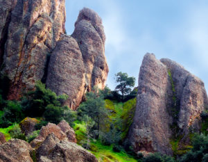
Indeed, most of the clues to the North Bay’s volatile past—Mount Konocti in Lake County, the Palisades of the upper Napa Valley—seem ponderously benign, their features softened over the millennia. But then sometimes I’ll be hiking on the Oat Hill Mine Trail or supervising a training-wheeled bike ride on a country lane, and I’ll see Old Faithful, a slender and silent but irrepressible plume. I take it as a reminder. Things may have calmed somewhat on the surface, but down below, nature’s fire still burns.
Calpine operates a Geothermal Visitor Center in Middletown (Lake County) and offers free tours of one of The Geysers’ plants. For more information call (866) GEYSERS or visit www.geysers.com.