.jpg)
When you’re whizzing down Highway 280 just south of San Francisco, it’s hard to miss that large swath of green on the hills to your west. Those 23,000 acres on the Peninsula make up a vast, seemingly untouched landscape remarkably close to our region’s urban core. Despite the thousands of people who drive by every day, it’s not so easy to get a closer look at that landscape.
It turns out that the land is owned by the San Francisco Public Utilities Commission (SFPUC), one of the Bay Area’s largest owners of contiguous natural habitat on land that, by some accounts, hosts the largest concentration of rare, threatened, and endangered species in the Bay Area, including the San Francisco garter snake, San Mateo thornmint, California red-legged frog, marbled murrelet, and steelhead trout.
Within these vast holdings run the headwaters of Pilarcitos Creek, a small but productive watershed rich in both biodiversity and human history. The creek was dammed in the 1860s to provide San Francisco’s first large-scale water source, and for more than 140 years the water utility has protected the land from logging and development. But all is not well in paradise: Creating those dams flooded valuable habitat, blocked migrating steelhead from some spawning habitat, and greatly reduced water flowing downstream for all wildlife.
Now a group of players has come together in an effort to better manage the length of Pilarcitos Creek, from the headwaters to the mouth at Half Moon Bay State Beach. The Pilarcitos Integrated Watershed Management Plan, slated for release later this summer, aims to “promote balanced solutions to effectively manage the Pilarcitos Creek watershed that satisfy environmental, public health, domestic water supply, and economic interests.” The coalition creating the plan includes farmers and municipal water agencies that use the water, environmental groups looking to protect habitat and species, and other local interests.

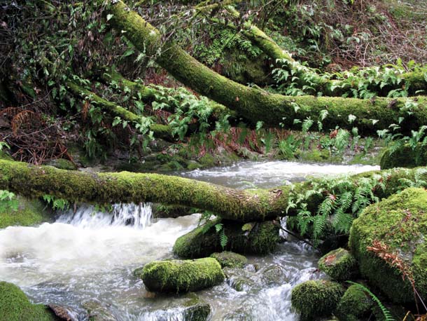
- In winter, strong flows below the dam produce rushing whitewater rapids. Photo by Dan Rademacher.
“One of the nice things about this watershed is that it’s complicated but it’s small,” says Tim Ramirez, manager of the watershed and natural resource division of the San Francisco Public Utilities Commission. “There is the opportunity to make big changes quickly, as riparian habitat can recover quickly.”
And although Pilarcitos provides just a fraction of SFPUC’s water supply, management changes here could be a harbinger of shifting roles for the utility, which increasingly must balance its primary mission—providing clean water—with the imperatives of habitat stewardship and the preservation of endangered species.
The Headwaters
One winter day, Ramirez accompanies me onto SFPUC land through the first of many locked gates, and we drive along the rim of Lower Crystal Springs Reservoir to a building that’s something of a cross between postwar ranch house and 19th-century hunting lodge. There we meet SFPUC Watershed Manager Joe Naras, our guide through these closely kept lands. Narrating the history of Pilarcitos along the way, Naras drives us into the green swath on a narrow service road that winds up the ridge.
In San Francisco’s earliest days, water was drawn from local springs. By 1860, with a population of 78,000, the city was poised for rapid growth but desperately needed a reliable year-round source of water. The Spring Valley Water Works, one of several competing private water companies, found an ideal source in the hills of the Peninsula, high enough at 1,000 feet that the system could be fully gravity fed. Spring Valley impounded the Pilarcitos headwaters, flooded the area to create the reservoir, tunneled through 1,500 feet of rock at Cahill Ridge, and then ran the water by flume and pipeline a dozen miles to the Laguna Honda Reservoir on Seventh Avenue.
The water company would later flood San Andreas Valley on the other side of Fifield-Cahill Ridge to create the upper and lower Crystal Springs reservoirs, both larger in capacity than Pilarcitos Reservoir. Still, says Naras, “Pilarcitos Dam is impressive: Imagine the hands, the horses, the wagons that constructed this in the 1860s, just after the Civil War. It’s only 14 miles from San Francisco, but it would have taken you a day to go to town at that time. The people who engineered this were remarkable.”
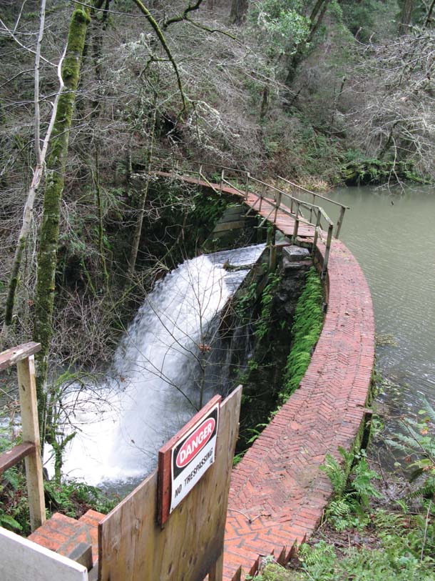
- Stone Dam, built in the 1870s, is still in use today, funneling water to both Lower Crystal Springs Reservoir and Half Moon Bay’s Coastside Water District. The dam’s 25-foot drop is impassable to steelhead coming upstream to spawn. Photo by Dan Rademacher.
Walking through the landscape, I can see how little has changed in the past 150 years. Below the dam is a quaint whitewashed house, home to generations of Watershed Keepers, employees hired to patrol the reservoir and conduct day-to-day operations. The surrounding land is lush and green, evidence that the micro-climate here is one of the wettest in the Bay Area, averaging 48 inches of rain a year. The trees and hills hide the urban sprawl to the east and north, and it’s so quiet I can imagine it still might take us a day to get back to the city.
We head downstream to Stone Dam, a diversion dam created to capture Pilarcitos waters farther down the canyon; redwood flumes once diverted water here back up to the reservoir, squeezing a bit more out of the watershed. Today, ring-necked ducks rest along the vegetated banks, and the impoundment looks more like a natural wooded pond—until you see the geometric lines of water flowing over its spillway at the lower end, dropping 25 feet to the stream below.
Downstream, water flows fast through the narrow canyon, occasionally eddying out into quiet pools. What’s most remarkable is what you don’t see—no tree stumps, no logging detritus. The old-growth Douglas firs stretch high overhead, competing for sunlight.
A remnant of the deep old-growth conifer forests that once blanketed these western Peninsula watersheds, the old trees here are home to a small population of threatened marbled murrelets, the only seabird that nests inland along the Pacific coast in watersheds such as Pilarcitos. Murrelets fly upstream along the canyon in search of old-growth Douglas fir trees with massive lichen-draped branches on which to hide their nests, built several hundred feet above the ground; some researchers believe that the murrelet chicks leave their nests by dropping into the stream and floating out to the ocean.
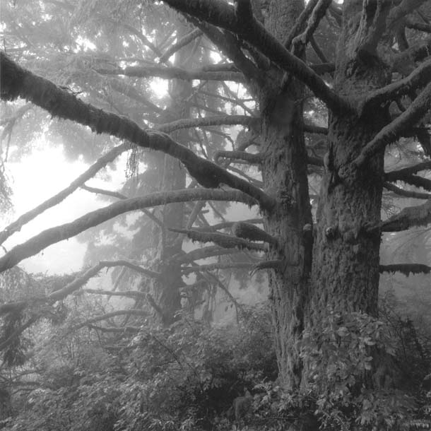
- The watershed has been off-limits to people for more than 100 years, and that has left intact stands of old-growth Douglas fir trees, preferred nesting habitat for marbled murrelets. Photo by Robert Buelteman.
These birds are almost impossible to spot, says Jules Evens of Avocet Research, who surveys Pilarcitos for marbled murrelets. “We stand there at dawn and [the murrelets] come in very fast. You hear them more than you see them flying over—it’s like seeing a football flying overhead, it’s so quick.”
Their elusive behavior makes sense: Murrelets lay only one egg each year, and that egg is coveted by ravens, jays, and other corvids. Pilarcitos provides good murrelet habitat for two critical reasons: It provides the old-growth trees these birds require for nesting, and it has very few humans and therefore very little garbage to attract the corvids that prey on murrelet eggs. Even though there are frequent calls for public recreational access to SFPUC land—little surprise, given its beauty and location— biologists believe the restricted access is critical for the murrelets and the other endangered species living along Pilarcitos.
The Middle Reach
On my next trip, I approach Pilarcitos from Highway 92 en route to Half Moon Bay, where it’s unmistakable that I’m entering the Pilarcitos drainage, thanks to the signs I pass along the way—Pilarcitos Cemetery, Pilarcitos Quarry, Pilarcitos Square. Small farms dot the landscape and several farmers sell their produce along the road. Dan Sare grows 60 acres of Christmas trees here, and owns another 520 acres as open space, including one mile of Pilarcitos Creek. “In my opinion it’s better to have the farmers there than anyone else,” says Sare. “Farmers have to be responsible—if you’re not, you’ll be out of business.”
Tim Frahm, director of the conservation and water quality program for the San Mateo County Farm Bureau, agrees: “Farming looks a lot different than it did 10 years ago. Everyone used to cultivate the hillside for barley, or in the real old days, flax. But those crops take water. There are some real thoughtful farmers along that watershed.” Local farmers are now growing new crop varieties that require less water.
But even with enlightened farming practices, demand for Pilarcitos water is increasing. Half Moon Bay’s Coastside County Water District pays SFPUC for Pilarcitos water sent downhill through a tunnel that parallels the creek. In fall and winter, Coastside taps from a well field just outside puc borders. Farther downstream, well water greens a cemetery and a golf course. With such demands, it takes a concerted effort—and a broad coalition—to keep the creek flowing.
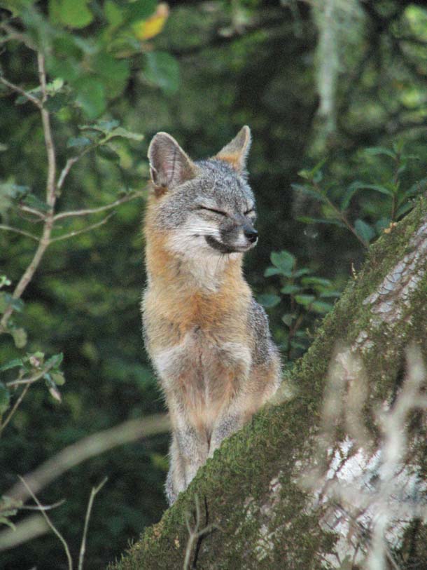
- A native gray fox on the watershed. Photo by Kevin Kasenchak.
It is, in large part, the presence of steelhead that has galvanized the disparate parties to come together to save the watershed. “It’s been made clear by our commission and [the San Francisco] board of supervisors,” says Ramirez, “that we have a responsibility above and beyond the regulatory issues to protect these species and the land. The open spaces are big, intact, contiguous, and you just don’t find that in a setting like the Bay Area.”
The coalition here took shape in the early 1990s when a sediment basin along Pilarcitos at the Ox Mountain landfill collapsed and damaged steelhead habitat, requiring waste company BFI, the owner, to pay out $1 million in fines. Along with money from the California Department of Fish and Game and the regional water board, this settlement funded a watershed assessment in which community work groups prioritized restoration goals along the whole creek. This led to restoration of riparian habitat, researching of water conservation options such as recycled water, and, most tangibly, removal of barriers—agricultural dams and metal culverts—that hindered fish passage. The watershed plan due out this summer continues the effort.
Steelhead, listed as a threatened species, can now make it as far as Stone Dam as they travel up the creek to spawn. The young steelhead fry spend from one to four years in freshwater creeks and ponds before returning to the ocean. “Steelhead are more flexible than salmon,” says Frahm. “If for some reason conditions are not good for spawning, they don’t have to spawn that year. If the stream drops too low, the steelhead can hide out.” When they live out their life cycle in freshwater, these fish are called rainbow trout—genetically identical to anadromous steelhead. Rainbow trout are thriving above Stone Dam, which was constructed in 1870—generations of cousins are separated by a few feet of masonry.
Removing Stone Dam is not up for discussion in the new watershed plan. But SFPUC has begun to release water during the summer months to bolster year-round flows in the stretch of creek below, solely to ensure the steelhead have sufficient water. Frahm describes an early spring steelhead sighting to me: “I just got a call this morning from a farmer on the creek telling me there are a couple of good-sized steel-head—10 pounders— waiting to get out. The fish go up and spawn and sometimes turn around and shoot out, but sometimes they loiter a bit, resting. Right now, they have refuge, but they better turn around and head downstream before the water dries up.”
Down to the Sea
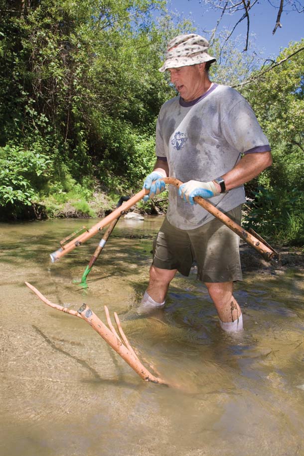
- Though the upper watershed is wild, the lower reach passes through farms and the city of Half Moon Bay. Volunteer Don Coyne removes a bed frame from the creek in Half Moon Bay during a cleanup sponsored by Save Our Shores. Photo by Mike Kahn.
I meet California State Parks resource ecologist Joanne Kerbavaz in the parking lot of Half Moon Bay State Beach, down near the mouth of the creek. Before introductions are finished she’s asking me my shoe size. “Waders,” she explains. “We can’t talk about a creek without getting in the water.” We slip on our state-issued plasticized pants and head over to the creek. Kerbavaz tells me that this property, including the last quarter-mile of Pilarcitos Creek, became state park land in the 1960s. Before that the land was farmed; historic photos show the geometric plot lines running right up to the beach dunes. Some areas have been replanted with natives, but Kerbavaz knows firsthand the complexities of restoration. “It’s not always so simple to ‘restore’ a landscape. It’s the notion of what was here before—but when? In these highly altered systems the creatures that remain have adapted. Restoration is a parlor game. It’s really asking, how do we create habitat for the species we most care about?”
We walk upstream from the beach’s parking lot, where the creek is now lush with willow, providing excellent cover for migratory songbirds.
Just past the state park boundary, we come upon a set of ponds that were constructed alongside the stream to provide habitat for California red-legged frogs, another threatened species found along Pilarcitos. Caltrans funded the pond installation as mitigation when the agency widened Highway 92. It’s relatively easy to create frog habitat—an old bathtub or livestock basin will do. I can hear the Pacific chorus frogs’ classic “ribbit” as I approach, but on this day the red-legged frogs prove elusive, though they’ve been recorded by surveyors. They vocalize for a few short weeks each year and their call is barely audible to humans—it’s described as sounding like a balloon being scratched under water.
As the creek reaches the Pacific, it briefly meanders parallel to the ocean, running alongside the sandstone bluffs. Nothing constrains the creek where it meets the ocean, and its course changes with the seasons. At the mouth, we wade through the early spring waters that run wide and shallow, problematic for fish (particularly with hundreds of hungry gulls perched on the sandbanks), but not impassable for the smaller steelhead.
One way to improve the steelhead’s chances would be to re-create a lagoon near the mouth of the creek. Historic photos show a body of water at the mouth of Pilarcitos, and some watershed players are lobbying to bring that back. Jerry Smith, a biologist at San Jose State who has surveyed Pilarcitos for several years, advocates for the lagoon: “[Right now] a small fish coming down Pilarcitos has no place to feed, no place to adjust to salt water, no place to hide. Without that lagoon their survival rates are very poor.”
Kerbavaz doesn’t argue that there once was standing water at the mouth, but it’s not clear to her that it was technically a lagoon, defined by a particular convergence of fresh- and saltwater. And she points out that altering the landscape at the creek’s mouth would require changes to the dunes, where snowy plovers nest. The plovers are yet another threatened species, and their beach nesting habits have made them especially vulnerable to human disturbance.
A feasibility study for the lagoon will be among the recommendations in this summer’s Integrated Watershed Management Plan. It is just one of many possible projects that, together, might make this watershed whole again.
But perhaps most important, the watershed plan has moved a diverse group of public and private players to the table to chart the future of a resource they all share and all need to protect. As Tim Frahm sees it: “The idea is not to achieve 100 percent for fish restoration, or 100 percent for domestic water, or 100 percent for the farmers. The goal is to figure out how we can use the water so that we all benefit—even the fish.”
Go to www.sanmateorcd.org/pilarcitos_iwmp.html for updates on the watershed plan.