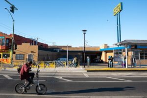
In East Oakland, on a residential street in front of a small park, Kristina Hill stopped and got out of her vehicle. She walked to the center of the street as a gaggle of graduate students emerged from their cars and gathered around her. It was midday, early September, the bright, hot sun directly overhead. Hill, a professor of urban and environmental design at UC Berkeley, had chosen the spot because when it rains heavily, water gushes up from storm drains here, forming filthy brown ponds. “That will happen more and more,” Hill said. Then she proceeded to describe a peculiar, almost apocalyptic future.
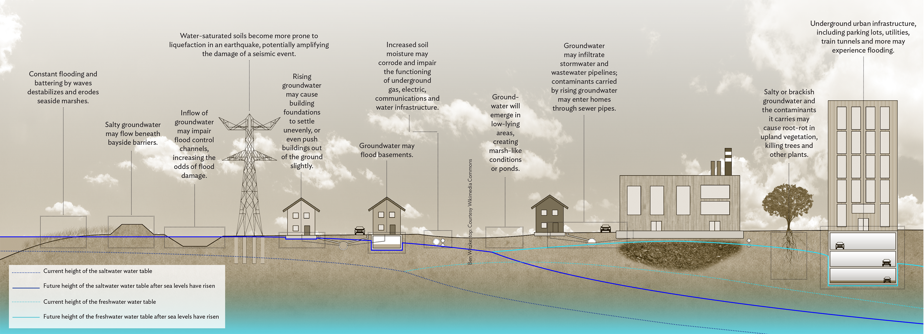
Water will leach inside homes, she said, through basement cracks. Toilets may become chronically backed up. Raw sewage may seep through manholes. Brackish water will corrode sewer and water pipes and inundate building foundations. And most hazardous of all, water percolating upward may flow through contaminants buried in the soil, spreading them underground and eventually releasing them into people’s homes. The coup de grace will be the earthquakes, which, when they strike, may liquefy the entire toxic mess, pushing it toward the surface.
The future Hill described is caused by a phenomenon called groundwater rise. In a nutshell, as a warming climate raises sea levels, the sea won’t only move inland, flooding low-lying land near the shore; it may also push water up from beneath our feet. That’s because for those of us living near the shore, a sea lurks in the ground—a saltwater water table. On top of that salt water floats a layer of lighter fresh water. As the salt water rises with rising seas, Hill and others think, it will push the fresh water upward. In low-lying areas, that water may emerge from the ground.
The result, Hill explained, will be that in places like Oakland, flooding will occur not just at the shoreline, but inland in areas once considered safe from sea level rise, including the Oakland Coliseum and Jones Avenue, where Hill and her students now stood, more than a mile from San Leandro Bay. In fact, she added, rising groundwater menaces nearly the entire band of low-lying land around San Francisco Bay, as well as many other coastal parts of the U.S.
The threat it poses can’t be neutralized with the usual strategy: physical structures that keep the sea at bay. No matter how many seawalls we build, many experts say, groundwater can still gurgle up from below, potentially turning large swaths of the densely populated shoreline around the Bay into unwanted, unplanned, possibly toxic wetlands. The issue is barely on the radar of Bay Area planners and decision-makers; it’s been mostly overlooked until recently. The public has hardly heard of it. Hill is trying to change all that. She’s on a mission to increase awareness of sea level rise’s gotcha-from-behind twin—groundwater rise.
When we think of the water table, we probably imagine a hard line that runs parallel to the earth’s surface some distance below us and, beneath that line, a big blob-like lake that we call groundwater. But it’s not really lake-like. Groundwater exists within permeable layers of rock, called aquifers, classified as either confined or unconfined. Water fills the space between rock particles. Confined aquifers are usually tucked deep in the earth, pressurized between less permeable layers of rock. Unconfined aquifers, like the one Hill described beneath Oakland, commonly exist in coastal areas and at river mouths. These aquifers often sit close to the surface, and they swell when, for instance, it rains. Only recently have scientists come to understand how sea level rise can affect coastal groundwater.
The seminal research on the phenomenon was conducted in Hawaii. In 2012, Kolja Rotzoll, a postdoctoral researcher at the University of Hawaii at Manoa, noticed that inland well water levels fluctuated with the occurrence of large offshore waves. If, for instance, a storm in the Pacific caused large swells that lasted for several days, well water up to three miles inland would also rise. High tides also affected water levels inland, Rotzoll noticed. Hearing about the observation, a colleague of Rotzoll’s, marine geologist Chip Fletcher, recognized that if tides and wave energy affected coastal water tables, then as seas rose, the water table would rise inland as well.
Rotzoll and Fletcher wrote up their findings, which were published in the journal Nature Climate Change that same year. The relationship between sea and groundwater levels they described applied to most low-lying coastal areas, not just Hawaii, and scientists across the country, from Florida to New Hampshire to California, took note. The study implied that many coastal areas were threatened by flooding that planners hadn’t even considered. Patrick Barnard, a geologist with the USGS in California, describes the paper as a wake-up call. “We may be missing a huge component of coastal vulnerability to climate change,” he remembers thinking.
Hill soon caught wind of Rotzoll and Fletcher’s work and mentally translated it to the Bay Area context. Around the Bay, most development has occurred on wetlands filled with sand, mud, and building rubble from 19th-century construction efforts, as well as alluvium, the material that washes down from surrounding watersheds. Fill and alluvium make up coasts in Hawaii, too, but the islands’ coastal plains also sit atop stabilizing fossil reefs and dunes. “I thought, ‘Huh, well, our geology is really different from Hawaii’s,’” Hill says. “But actually, we’re different in a bad way.”
That’s largely because the Bay Area must also consider earthquakes, which can exacerbate the problems posed by rising groundwater. This lesson was driven home in Christchurch, New Zealand. In 2011, the city of just under 400,000 people experienced aftershocks from a 6.3-magnitude earthquake that unleashed horrific damage. One-hundred and eighty-five people died, 80 percent of the city’s underground infrastructure was obliterated, and thousands of buildings were leveled. Why? The city was built on a sand-and-gravel plain with a high water table. When the earthquake struck, the soil acted like a liquid, partly swallowing vehicles and cracking and tilting buildings. It is a problem shared by and well-known in the Bay Area.
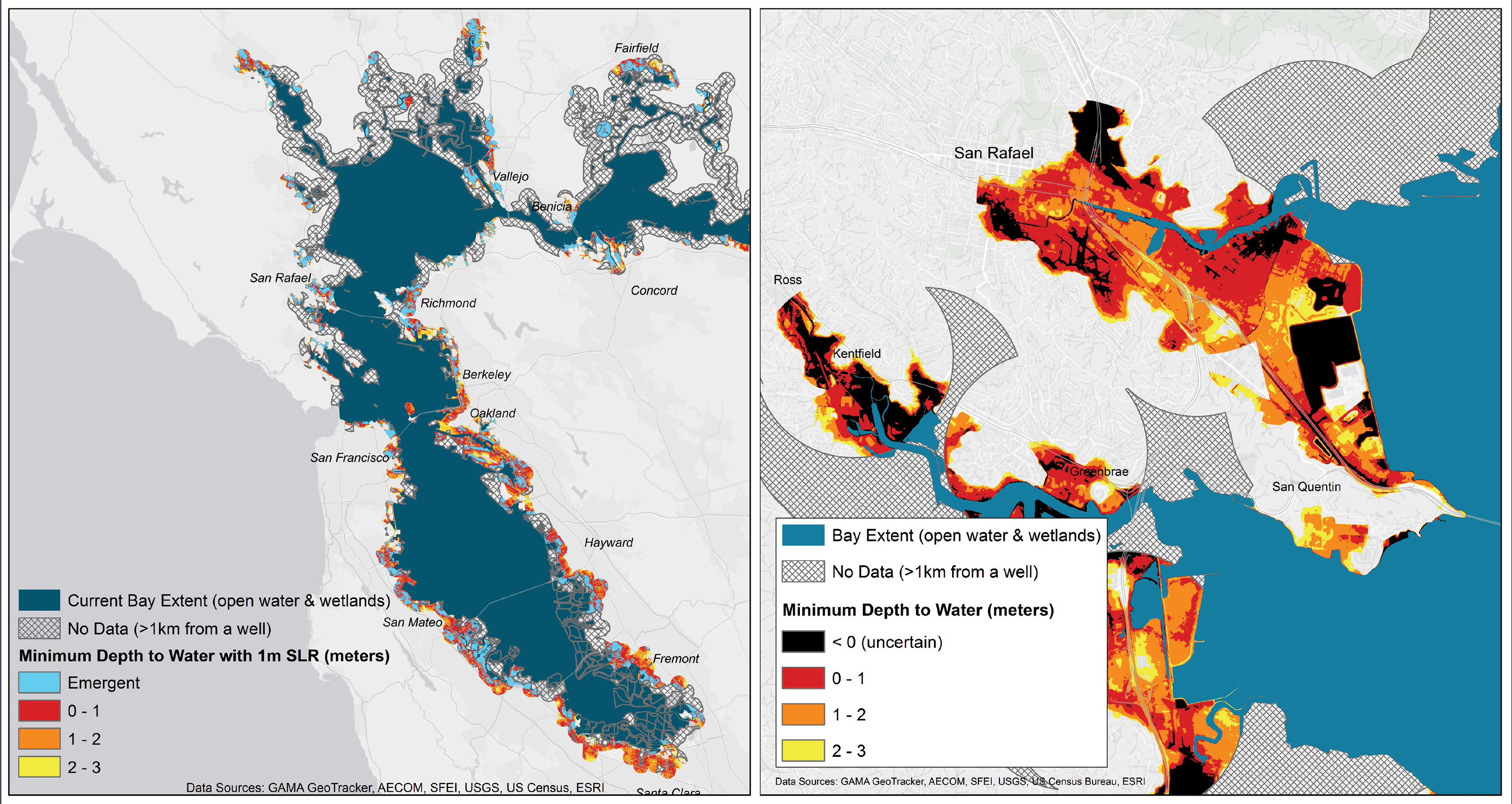
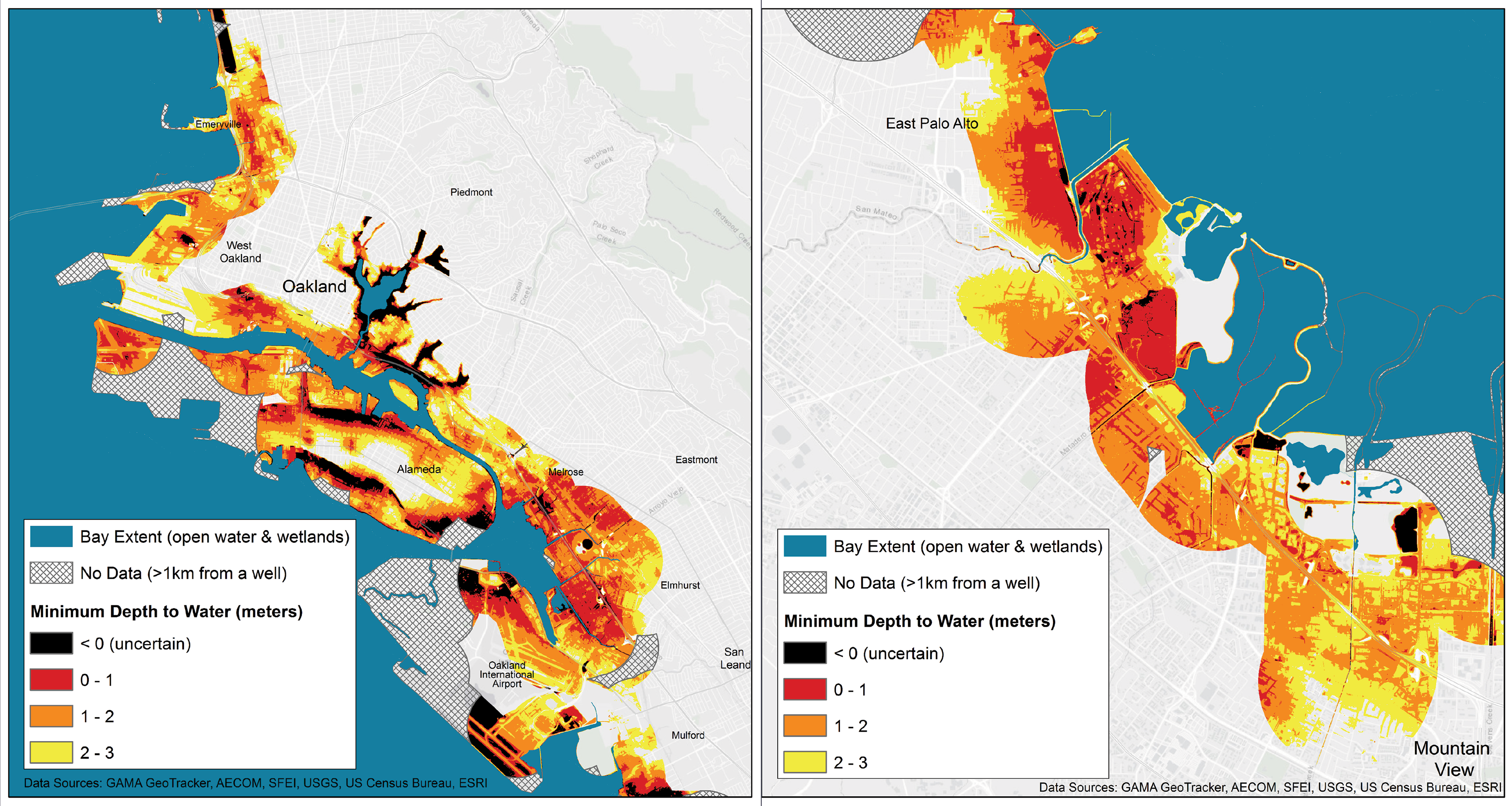
The USGS has liquefaction susceptibility maps for the Bay Area, but these don’t account for sea level rise. Municipalities needed to incorporate the risk posed by rising water tables into their climate adaptation plans, Hill realized. But she knew she’d need data to convince anyone that the problem was real. Detailed information about water tables around the Bay at that point was lacking. That’s partly because the complex geology around the Bay complicates mapping efforts, and partly because municipalities tend to map groundwater only when they plan to draw from it, which the cities around the Bay generally don’t do (with some exceptions). So in 2017, Hill and graduate student Ellen Plane analyzed a data set from the state water board that contained water-level measurements from water wells around the Bay. The wells, originally installed to monitor groundwater pollution, allowed mapping of water table levels near the shore.
The results, released in 2018, were unsettling. The water table was already high in many areas, meaning that as the sea rose, large patches of land would eventually, if they hadn’t already, be subject to rising groundwater. Hill and Plane’s maps provided information, not predictions, yet they suggested that anything between the assumed 1 to 3.2 feet of sea level rise by 2100 would not be pretty, especially when combined with projected subsidence. As sea levels gradually rise in the decades to come, water might push up through storm drains or directly through the ground, damaging infrastructure and building foundations. Freeways and airports near the sea (and there are many, SFO and Oakland International Airport included) would likely become soggy messes. Inundation at wastewater treatment facilities, often sited on low-lying land, could trigger leaks of untreated water. Rising salt water might corrode urban drainage systems, which would stop functioning properly as their pipes filled permanently with groundwater. Brackish pools of water could become regular features of the urban environment.
More worrisome, rising groundwater might carry toward the surface hazardous material trapped in the soil. In Hawaii, Honolulu saw this happen about 10 years ago after two months of rain. A slick of diesel fuel, gasoline, and oil (spillage from the city’s military history) sits above the water table, so when the water table rose, it pushed the pollutants upward. Fumes of gasoline wafted from the ground. Grass and trees died. “There was a real fear of spontaneous combustion,” Fletcher says. The slick itself didn’t surface that time, but next time it might. And around the rim of the Bay, once a center of heavy industry, we could see worse: arsenic, lead, benzene, polycyclic aromatic hydrocarbons, PCBs, even possibly radioactive waste.
Last September, the same day that Hill described the regurgitating sewers, she directed her caravanning students to pull over on another East Oakland residential street. They were, again, about a mile from San Leandro Bay, in a different direction this time, and a half mile from the Oakland Athletics’ ballfield. Here, Hill was showing them how the pollutant problems in Hawaii could occur locally.
Everyone crowded around a chain-link gate wedged between two squat, single-story homes. The gate, hung with vertical, half-broken wooden slats, obscured a 12-foot drop to a channelized creek below. The water was low; the space between its concrete walls looked more swamp than creek.
“The highest tide of the year comes in almost to where we’re standing,” Hill said, noting a dark mark on the channel’s concrete. Hill reminded her students that, periods of drought aside, rainfall is predicted to become more intense as climate changes. Flooding would likely become more frequent, bringing to the surface various buried toxic substances, such as the vinyl chloride and TCA of concern in the groundwater beneath the nearby tool and die machine shop, or the gasoline in the groundwater around the neighborhood’s former and existing gas stations.
Even if the water table recedes after the rainy season and the summer dry season sets in, she pointed out, some of these contaminants could become airborne in buildings. People may inhale them. “Even an event where it’s a seasonal thing for a few days could have really important long-term effects,” Hill told me.
East Oakland is already among the top five percent of polluted California zip codes. The mostly low-income, primarily nonwhite residents who live there have relatively high rates of chronic disease. Life expectancy for African Americans in the Oakland “flats” can be up to 14 years less than in the hills. And now these already beleaguered communities face the prospect of contaminants welling up from beneath their feet.
Not everyone agrees with Hill’s assessment of East Oakland. Representatives from SFPUC and the San Francisco Regional Water Board say they have a robust pollution monitoring system in place. “Adaptive management is something that we’ve embraced,” says Tina Low of the San Francisco Bay Regional Water Quality Control Board. “If our remedies are no longer protective, we can go back and do something else.” (Hill counters that they don’t monitor often enough to catch an issue that can show up suddenly—in the space of a single king tide, for example.)
But in a general sense, others recognize that pollutants could pose a problem. Rising groundwater is “a whole new game-changer, particularly when you’re talking about sites that are contaminated with industrial solvents,” says Grant Cope, the deputy secretary for environmental policy at the California Environmental Protection Agency. What can be done? Contaminated groundwater could be pumped out of the ground, treated, cleaned, and reinjected into the aquifer, Cope says. Otherwise, it remains unclear whether caps meant to keep pollutants buried—a strategy used at remediated sites in recent decades—would continue to work if groundwater rises. The caps were not designed for this purpose, Cope says.
Judging by what the federal EPA has learned from its experience with hurricanes in other parts of the country, the most acute risk posed by groundwater rise are infections from pathogens in wastewater, according to John Blue, Cal EPA’s manager of climate programs. (Hill disagrees, saying, “I would take a bath in wastewater before I would have any skin contact with benzene”—one of the pollutants she worries about in Oakland. “There’s no safe exposure” level.) And how would affected wastewater be dealt with? Blue pauses. “These are very difficult questions,” he says. “That’s the eight-hundred-million-dollar question. That remains to be seen.”
There are important caveats to the wet, bleak future scenario Hill and Plane’s report describes. Their maps, which have been submitted for publication but haven’t appeared in a peer-reviewed journal yet, are approximate and don’t account for subtleties in the landscape—for instance, streams and valley-like topography that might allow rising groundwater to flow downhill and away, preventing water from pooling. Hill and Plane’s conclusions assume that water tables will rise linearly with sea level rise, which, judging from patterns in local geography, may or may not be true. The report’s data is based on the highest water table levels recorded in the past 20-odd years, which may present an exaggerated picture of what’s likely to happen, says Kevin Befus, assistant professor at the University of Wyoming’s College of Engineering and Applied Science. Tina Low of SFRWQCB maintains that, in conjunction with monitoring, current remediation standards for buried pollutants are sufficient to prevent leaching, even if groundwater rises. (Older sites that don’t adhere to these standards may need to be studied to assess the risk they pose, she adds.)
Still, many planners I queried around the Bay found the study both credible and worrisome. “It’s a really nice data-driven approach that leverages this incredible data set [from] wells to look at where the water table actually is,” says Patrick Barnard of the USGS. Abby Mohan, a marine geographer at Silvestrum Climate Associates, who is working with Hill and Plane to further refine their research, emphasizes that this is pioneering, groundbreaking work. “Ellen and Kristina did something really interesting and great,” she says.
Steve Goldbeck, chief deputy director of the Bay Conservation and Development Commission, says the commission had been aware of the groundwater issue in a general sense before, but with Plane and Hill’s work, “now we know it’s going to be a problem” in the Bay Area.
Thus far in recent history, the three general responses to sea level rise have been to armor, to retreat, or to adapt in place. Around the Bay, many municipalities are considering the least radical strategy: armor. San Francisco aims to rebuild its seawall, a more than $2 billion project that won’t address groundwater issues (though it does, importantly, address seismic hazards). Moreover, as the sea rises, seawall construction could actually increase water levels in the Bay, says Mark Stacey, an environmental engineer at UC Berkeley who has modeled such scenarios. If, for example, Foster City, San Mateo, Redwood City, and Menlo Park all erect seawalls, those barriers together could alter tidal amplification enough to raise water levels in the Bay, potentially worsening flooding in other areas.
Planners elsewhere are taking bold actions to address groundwater rise. Miami envisions using urban green space as a sponge to draw out and absorb groundwater. Boston recently unveiled a plan for its harbor that uses barrier walls to keep the sea out as well as tidal marshes and parks to absorb emergent groundwater. (The Bay Area has restored tens of thousands of acres of wetlands, but unlike in Boston or Miami’s plans, they’re not tightly integrated into the urban landscape. So it’s not clear that they can serve the same “release valve” function, drawing groundwater away from infrastructure.) And in New Zealand, after the devastation of the 2011 earthquake in Christchurch, the government purchased and then razed more than 7,000 homes on land at risk of further liquefaction, essentially an admission that some areas of the city’s plain were too dangerous to inhabit in the short term without greater fortification.
Things have moved more slowly in the Bay Area. That’s partly because the Bay’s geology is more complex than along the Eastern Seaboard and scientists don’t yet have all the data, and partly because Bay Area decision-makers want greater certainty on what to plan for. “We’re ready to apply [the information] as soon as we really understand the risk,” says San Mateo County climate adaptation manager Hilary Papendick. Phil Bobel, Palo Alto’s manager of public works engineering, echoes that view, saying the city leadership now assumes it will have to deal with groundwater rise eventually but wants more research first.
Bay Area planners eagerly await USGS models in development that will allow them to predict, with greater accuracy than Hill and Plane’s maps, how the coastal water table will respond to sea level rise. The models, which use Hill and Plane’s data set for validation, are slated for public release later this year. With them in hand, “we’ll incorporate that understanding into our broader adaptation planning,” Alex Westhoff, a planner at the Marin County Community Development Agency, says.
But even with these models available, next steps aren’t necessarily clear because the problem is so new. Replacing and shoring up infrastructure and implementing other adaptation strategies will be expensive, so the biggest hurdle may be funding. “It’s a multibillion-dollar area, and we struggle in the millions to try to do shoreline restoration,” Paul Detjens of Contra Costa County Flood Control and Water Conservation District says. “We’re talking a whole ’nother order of magnitude.” In 2016, Bay Area voters passed Measure AA to fund wetland restoration, so there is reason to think that as they become aware of the issue, voters might support adaptation initiatives that address groundwater rise.
Hill has her own bold ideas for how the Bay Area can prepare. She, Kevin Befus at the University of Wyoming, and Chip Fletcher at the University of Hawaii think that learning to live with water, rather than trying to keep it out, is the best way forward. “If you wage war with water you will lose,” Fletcher says, paraphrasing a Dutch expression. Hill imagines floating cities in ponds, or neighborhoods linked by canals—a Californian Amsterdam. The idea is to manage emergent groundwater by opening space for it in the cityscape. Canal systems installed in flood-prone areas of East Oakland, for example, would help existing structures remain in place a bit longer; elevating and retrofitting for seismic risks is too expensive, she says. Over time, as groundwater rises, neighborhoods could become what she and her colleagues call “tidal cities.” Homes, apartment buildings, and businesses could rest atop floating pontoons connected to land.
Those ideas may sound far-fetched, but planners welcome them. “We’ll need creative solutions for design and planning,” Westhoff says.
Rohin Saleh, a civil engineer at Alameda County Flood Control who has watched the water table rise over the past 15 years, says Hill’s vision may not be feasible everywhere, but “is a really great component of the type of solution that we need to have in our backpack.”
Many questions remain unanswered. Who will pay for urban adaptation, cleaning and remediation? How will the many municipalities around the Bay come together to manage what is, by definition, a regional problem that no one area can solve alone? And what, for that matter, does a floating apartment building look like? Whatever the answers to these questions, one thing is certain. As Lindy Lowe, the Port of San Francisco’s resilience program director, says, at least people are thinking and talking about groundwater rise now—which they weren’t doing eight to ten years ago. That, she notes, is already a triumph.