.jpg)
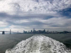
On an overcast day this winter, seven of us met for a bike ride through Richmond on the Bay Trail. We rode along Cerritos Creek, under two busy freeways, and out to the shoreline. At Point Isabel Regional Shoreline, we were greeted by a vista that runs from the Bay Bridge and San Francisco skyline past Mount Tamalpais toward the Richmond Bridge.
How did the gritty, industrial city of Richmond—known for crime, dysfunctional schools, and a massive oil refinery—come to be the biggest player in the ambitious plan to complete a 500-mile Bay Trail that will circle San Pablo and San Francisco bays?
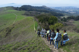
Part of the answer is that Richmond simply has more shoreline—32 miles—than any other city on the Bay. Another part is the Trails for Richmond Action Committee (TRAC), an all-volunteer group of 600 that organizes residents, browbeats public officials, vets development proposals, and gets people out to enjoy their Bay shoreline. Twenty-four miles of Bay Trail are complete and at least ten more should be ready in the next five years.
Already, cyclists can follow Bay Trail routes (with some stretches on city streets) from Golden Gate Fields along Eastshore State Park to Miller-Knox Regional Shoreline, then north past San Pablo Creek. And TRAC is working with local agencies to extend the trail north to Point Pinole and to improve public access at Point Molate, a former navy facility where the Richmond City Council has approved a controversial Indian casino development.
When eight Richmond residents formed the committee in 1999, local activists were already pushing for more shoreline access, but it was TRAC that saw the potential of linking that goal with the larger vision of a Bay Trail.
“Richmond had pieces of shoreline up for development,” says cofounder and president Bruce Beyaert, “but one issue was getting lost in the shuffle: fitting the Bay Trail into the proposed projects. We tried to persuade [Richmond] to make the trail one of the city’s top priorities.”
Cofounder Whitney Dotson grew up in Parchester Village, south of Point Pinole. As a kid, he frequently sneaked across the Southern Pacific tracks to the Bay shore. Still, Dotson never dreamed of having access to the rest of Richmond’s shoreline. “TRAC offered the first opportunity for residents to experience the shoreline,” he says.
Perhaps the most remarkable new trail segment is the three-mile loop around the West County Landfill, situated between Wildcat and San Pablo creeks. The first half of the loop opened in 2006 and runs along Wildcat Marsh, a haven for migratory waterfowl in winter and spring. The second half of the loop will open this fall after the northeast corner is capped and will include a trail halfway up the hill, offering Bay vistas.
The trail here is fairly typical of TRAC’s accomplishments: years of advocacy to fund trail work and convince landowners or agencies to take on construction and maintenance. “The [landfill] trail has been going on over ten years,” says Beyaert, “with many players and a lot of tenacity.” The landfill operator is building and maintaining the trail, while TRAC coordinated the design of trailside interpretive signs.
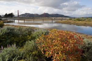
Richmond’s most formidable remaining Bay Trail challenge —”a frustration and a stalemate,” in Beyaert’s words—is a safe route to Point Molate and the Point San Pablo peninsula. In 2000, the U.S. Navy turned over part of the peninsula to the city, but getting there by bike or foot means traveling along the shoulder of I-580, because Chevron—citing security risks—has refused to provide a trail easement over its property.
Last October, a car struck two bicyclists in the bike lane, killing one and severely injuring the other. The committee alerted its supporters to the tragedy and implored them to ask officials to push Chevron for an easement, which the State Lands Commission could require for a pending lease renewal.
Another long negotiation ended in victory in January when Toll Brothers accepted a Bay Trail design for Seacliff Estates, adjacent to Miller-Knox Regional Park.
Extending the Bay Trail to Point San Pablo would give Richmond residents—and the rest of us—access to a dramatic promontory overlooking San Pablo and San Francisco bays. It would be a fitting exclamation point to the perseverance that has put Richmond at the forefront of a remarkable regional trail.
Find out more at www.pointrichmond.com/baytrail.