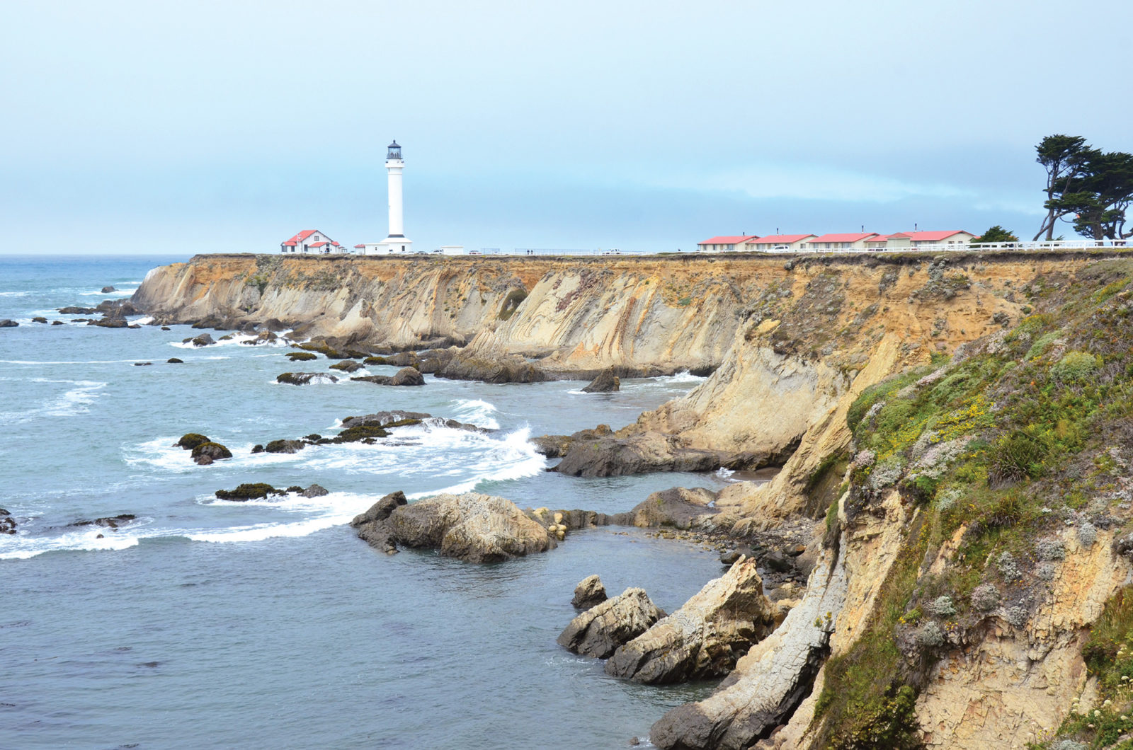
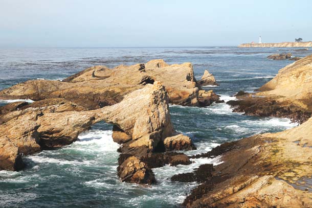
Point Arena, not the seaside quaint town but the actual landform that juts into the Pacific, is dominated by its historic lighthouse: The rugged rock reefs seem to merge with the historic structure in single point perspective. It’s easy to imagine the towering light, when operational, reaching out to the sea, warning sailors of danger and linking land and sea with its endless revolutions.
These days, with the lighthouse dark, the human connection to the sea is less obvious, but unusual natural links between land and ocean remain: This jutting point of land helps stir up nutrient-rich waters that fuel the remarkable biodiversity found offshore at Cordell Bank and the Farallon Islands, not to mention around the countless seastacks and reefs that make this stretch of coastline so remarkable.
The link between dry land and deep water may soon be better recognized thanks to twin efforts to link together 3,300 acres of spectacular public shoreline and to make that land part of the California Coastal National Monument, a sprawling protected area almost no one’s ever heard of.
From scenic Point Arena Cove to Irish Beach, almost 11 miles to the north, all of this coast is now public land, including the just-acquired 409 acres known as Cypress Abbey Phase 2, which until this year remained in private hands and thus split a potentially large protected area in two.
In late July 2013, the Trust for Public Land (TPL) completed purchase of Phase 2, so the public now has access to the entire stretch, more than 10 miles. “It’s a spectacular, terrific representative of the California Coast, and now there’s public access from behind city hall,” says Sam Hodder, TPL’s California state director. “It isn’t about today; it’s about people making memories into the future. The view itself is the wow factor. Step out on the coastal bluff, and it takes your breath away.”
Even though the California Coastal National Monument was created by President Bill Clinton in 2000, I had never heard of it when I arrived last fall at the Point Arena City Hall to see that view, tour the land, and meet some of the people working to protect this coastline.
It’s no surprise that the monument is a bit obscure: It’s the only national monument that’s totally offshore, composed of islands and rocks along California’s 1,100-mile coastline, from Oregon to Mexico. Senator Barbara Boxer and Representatives Mike Thompson and Jared Huffman have proposed legislation to make the public coast around Point Arena the only onshore portion of this little-known national monument. If Congress fails to act, President Obama could make the designation himself.
“Most of these bluffs are already public land,” says Ryan Henson of the California Wilderness Coalition, “yet they lack the protection of places like the Golden Gate National Recreation Area, Redwood National Park, or the King’s Range Wilderness.”
But they deserve as much protection as they can get.
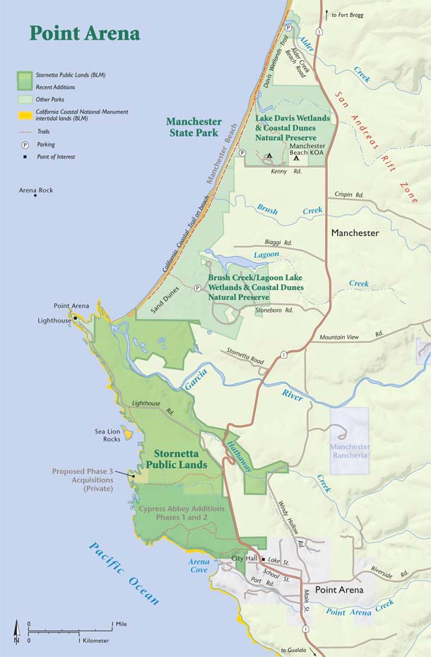
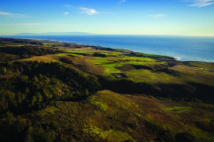
As we started the tour, a short walk took us to the bluff behind city hall, high above the cove, delivering on Hodder’s promise of stunning views of the coast, the pier, and some fishing boats bobbing in the swell. This slice of bluff is Cypress Abbey Phase 1, 123 acres owned by the Bureau of Land Management since January 2012.
Continuing north, we came to a gate with a “no trespassing” sign: the just-acquired 409 acres of undeveloped coastal bluffs and critical habitat of Phase 2, with over a mile of coastline, which forms a central link connecting more than 3,300 acres of permanently protected open space north and south of this parcel. Now the public can walk the entire way up to Manchester State Beach and see why this needs to be public land. Eventually, it will be turned over to the BLM.
At the first point, we spotted humpback whales just outside the kelp line, undulating through the swells. It wasn’t until months later that I realized I was looking out over two of California’s new Marine Protected Areas.
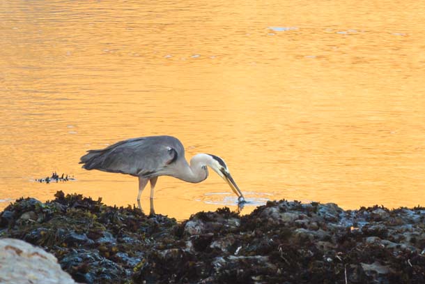
The coastline here was already known to be rich in birdlife, with black oystercatchers, pigeon guillemots, and even the occasional Laysan albatross winging in from the open ocean. This summer, scientists from the Davis-based California Institute of Environmental Studies announced they’d discovered rare ashy storm-petrels nesting on rocks off the Mendocino Coast, rocks already protected as part of the California Coastal National Monument. Their discovery was the farthest-north nesting record since 1926.
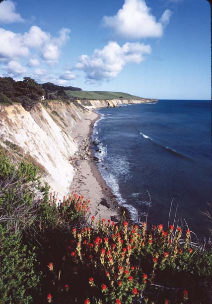
So there’s much to be discovered here, even if you stay on shore. Nearing Sea Lion Rocks, one of the locals diverted our group to a couple of spots near the point where we found two blow holes: Waves broke into unseen caves below us, pushing air out through small holes with enough force to blow our hair straight up. We were reminded of the effects of constant erosion in the area. In fact, a bit further we walked by a large sinkhole with a small tunnel to the ocean. One day in the not too distant future, there will be a narrow land bridge that will eventually collapse, making this sinkhole into another of the many pocket beaches along the coast.
After hiking about three miles, we crossed a small creek and followed it to the edge of the bluff. It ended in a small waterfall that disappeared into cracks in the coastal rock. Waterfalls also poured off the rugged and impressive reefs below us.

The waterfalls, along with the flat terrace on which we walked, are testament to this area’s remarkable geology, which is why Tom Williams, a geologist who works by day for the North Coast Regional Water Quality Control Board, always makes several stops here on the three-day Mendocino Coast field trips he leads through his company Williams GeoAdventures.
“One of the things that’s really distinctive about the Mendocino Coast is the series of uplifted marine terraces there,” he says. “You get these wave-cut benches that are created at high sea-level periods, like today.”
During glacial periods, sea level drops, and subsequent tectonic forces lift the benches, which become flat, dry terraces. If this happens multiple times, you can get staircases of multiple terraces (as at Jug Handle State Natural Reserve, 40 miles to the north) that speak of huge sea-level fluctuations and tectonic movements. And there’s plenty of tectonic movement going on here, as the queen of our California faults, the San Andreas, leaves land for the last time just north of Point Arena (the actual geologic point, not the town) at Manchester State Beach and disappears into the ocean on its way to the geologically hyperactive Triple Junction 200 miles to the north.
But even the single terrace at Point Arena creates plenty of drama. It was eroded by waves at sea level about 100,000 years ago, says Bay Area geologist John Karachewski, and uplifted to its present elevation by continued and active mountain building along the California coast. “The sedimentary layers exhibit different hardness,” he explains, “which the waves exploit to erode the land into these scenic and beautiful headlands, coves, and sea caves.”
When he visits, Williams likes to take his field trip participants back and forth across the San Andreas Fault as they travel from Fort Ross up to the town of Mendocino. On the west side, the rocks of the Gualala Block have moved approximately 300 miles north along the San Andreas and are significantly different from Franciscan Assemblage rocks east of the fault. “It’s a fascinating area, especially right there around Point Arena. Compression along the fault has folded and faulted the Gualala Block rocks,” he says. “This folding is kind of like two people pushing opposite edges of a rug together.”

With the fish-bearing Garcia River meeting the Pacific just north of Point Arena, the great diversity of life here includes coho and chinook salmon and steelhead. There is even a resident albatross, nicknamed “Al” by the locals, that hangs out with the gulls in the cove from November through March. Three federally protected species reside on the land side here as well: Point Arena mountain beaver (a rare burrowing rodent native only to this area) and Behren’s silverspot butterfly, both endangered, and threatened California red-legged frogs.
“This is an amazing opportunity, right in our own front yard,” says Marita Watley, a manager at the lighthouse. “People can hike, bird watch, and take photographs in a place that is [accessible], yet still wild. It’s a great destination for visitors, locals, and children’s groups.”
Point Arena City Manager Hunter Alexander has been working toward both acquiring Cypress Abbey Phase 2 and securing National Monument status for the whole area. She did, however, caution that there were some issues that need to be addressed: signage, parking, restrooms, and other visitor facilities.
At the moment, the park has a very small-town feel: There’s no sign indicating the trailhead behind city hall, and people come in to ask directions and use the restroom (there are none on the trail). Alexander drops what she’s doing to help them, hand them a brochure, and point them to the trailhead. “Helping them is fine with me when we’re open,” Alexander said, “but we’re not always open.” Alexander said she has already put an informational kiosk and some literature inside city hall for the visitors who come in looking for the trail.
Leslie Dahlhoff, who served ten years as mayor of Point Arena and has continued to champion local public lands, looks forward to even more protections offshore: She says the Cordell Bank National Marine Sanctuary is considering extending to Alder Creek at the north end of Manchester State Beach, which just happens to be where the San Andreas Fault goes out to sea, dividing our two crustal plates. It does seem like everything is coming together in Point Arena.
GETTING THERE:
The town of Point Arena is located on Highway 1, about 15 miles north of Gualala and about 25 miles south of Highway 128 in Mendocino County. Highway 1 makes a left at the north end of town, becoming School Street. The city hall is about two blocks up on the left. The trail starts at the back of the parking lot. A second access point is off of Lighthouse Road to the north of town. Where the road reaches the bluffs, there’s a sign on the left and a stile.
Another access point is a trailhead at the end of Stoneboro Road, about two miles south of Manchester. From there it’s a half-mile walk to the beach over the rolling dunes. Miles to the north, Irish Beach would be the northernmost access to this stretch of coast.
You can also camp at Manchester State Beach, which makes an excellent base for exploring the area. Or learn about Tom Williams’s geology field trips at geology-adventures.com.
Meade Fischer is an outdoor adventure and travel writer specializing in the west coast. He writes
regularly on hiking and kayaking and is the current president of Outdoor Writers Association of California. His latest book is With the Sea Beside Me: An intimate guide to California’s central and north coast.