.jpg)
In the middle of Hayward, in a parking lot right at the corner of Mission Boulevard and A Street, is a crack in the asphalt. It is not just a little chink or a small crevice, but a long straight line running through a dozen or so parking spaces in front of an Italian restaurant. This crack wasn’t caused by heat or rain, nor by a contractor’s neglect, nor even by the wear and tear from the cars driving over it. This crack and many others similar to it in East Bay cities from Fremont to Richmond are subtle reminders that someday soon, without warning, all hell will break loose along the East Bay hills. The line in the parking lot marks the path of what many geologists consider California’s most dangerous earthquake fault.
A repeat of the last great shaking on the Hayward Fault–140 years ago in the early morning hours of October 21, 1868–would today result in the deaths of hundreds if not thousands of residents. It could also cause $500 billion in damages due to fires, road and bridge collapses, and power outages throughout six counties that are home to over five million people. Roland Buergmann, a geoscientist at the University of California in Berkeley, calls the Hayward Fault “a tectonic time bomb in our backyard.”
There is, however, an inherent contradiction in the active earthquake faults in Northern California: While they are capable of wreaking total havoc at any time, tectonic activity along these faults over millennia has created, and continues to create, the beautifully varied landscape of the Bay Area that lures so many people from all corners of the globe, despite the danger lurking beneath our feet.

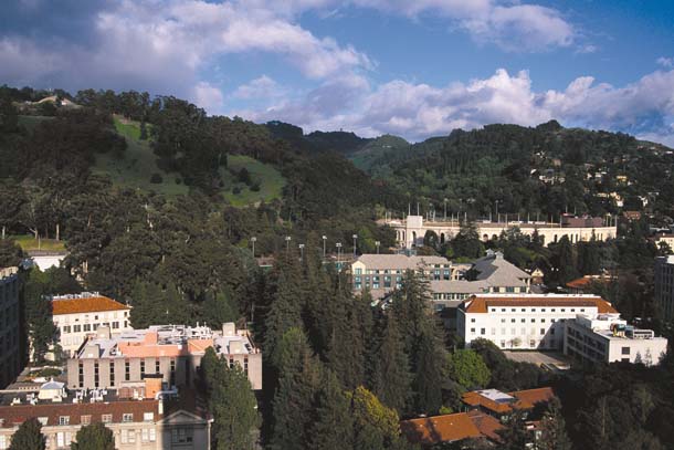
- Movement along the Hayward Fault created the East Bay hills, but also imperils structures like UC Berkeley’s Memorial Stadium (center right), which sits atop the fault. Photo by John Karachewski, www.geoscapesphotography.com
The Hayward Fault, named after the city at the epicenter of the 1868 earthquake, underlies some of the most densely populated places in the Bay Area. It is crossed by five major freeways and several water tunnels; BART and other rail lines also intersect it at several locations. This urban fault line is an immediate product of plate tectonic movement, the strike-slip motion between the gigantic Pacific Plate and its continental counterpart, the North American Plate. Between Los Angeles and the Bay Area, the boundary between the two plates is largely defined by the San Andreas Fault. In the Bay Area, however, the movement of the two plates is more fully distributed over several faults. For reasons that are not yet clear, the tectonic movement in the Bay Area is spread over several fault lines that roughly parallel each other in a 50-mile-wide band of seismic volatility.
The main strand is the San Andreas Fault itself, running under the coastal hills west of San Jose and along the spine of the Peninsula. At Daly City, it runs north into the ocean, only to appear on land again near Bolinas Lagoon and proceed through Tomales Bay. The Calaveras Fault branches east from the San Andreas south of Hollister and turns northwest, running under the towns along Interstate 680 all the way to Walnut Creek and Concord.
The Hayward Fault is sandwiched between the San Andreas and Calaveras faults, running for approximately 50 miles along the foothills of the East Bay. It splits off from the Calaveras Fault near Arroyo Agua Caliente Park in the Warm Springs District of Fremont and follows a northwesterly line through Hayward, Oakland, and Berkeley to Point Pinole in Richmond, where it disappears under San Pablo Bay.
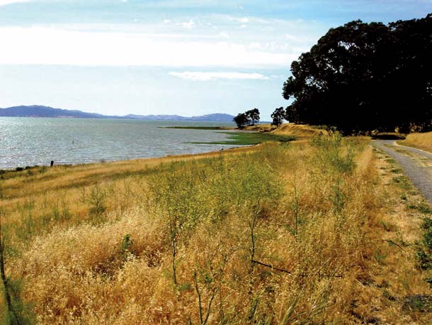
- At Point Pinole Regional Park in Richmond, the fault trace is marked by a low scarp (center, below trees) that extends toward San Pablo Bay. Photo by Horst Rademacher.
It is this widening of the boundary zone between the two plates that forms the unusual landscape of the Bay Area. Because the three major fault lines take up the plate movement and essentially split the tectonic sliding among themselves, most topographical features here follow the northwesterly trend defined by the plate boundary.
Look at some of the major roads in the Bay Area. Interstate 280 on the Peninsula, Highway 13 in Piedmont and Montclair, and the 680 corridor all parallel each other because road builders used the valleys conveniently formed by the three faults to lay out part of the highway network. Not only the valleys but also the crests of the various hills in the Bay Area follow the northwesterly trend, as defined by the plate boundary.
The overall tectonic movement between the two plates is about two inches per year, with the Pacific Plate moving north-northwest relative to the North American. Earth scientists have calculated that over the last 2,000 years the Hayward Fault has taken up about one quarter of that movement, slipping slightly less than half an inch per year.
Such a number is, of course, a long-term average. For most of the time, the largest sections of the San Andreas and the Calaveras faults do not move at all. Instead the stress and tension caused by the plate movement builds up in the rocks. But like a rubber band that is stretched too far, these rocks can break when they get pulled too much–resulting in an earthquake. During the quake, the two flanks of the fault–which are normally locked together as they strain against each other–release and slip past each other with supersonic speed and tremendous force. Generally, the greater the mechanical strain accumulated in these rocks, the larger the resulting earthquake and the longer the resulting slip. Scientists calculate the plates’ average movement from the sum of those earthquakes over the centuries.
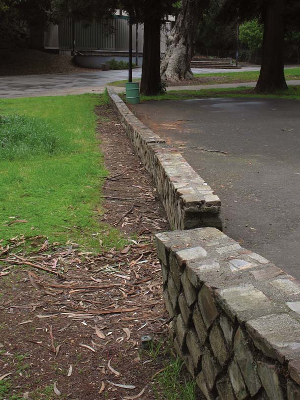
- In Hayward’s Memorial Park, this 1930s wall has been noticeably offset by fault creep. Photo by John Karachewski, www.geoscapephotography.com
A sudden release of seismic energy like that can certainly occur along the Hayward Fault, as it did in 1868. But in contrast to its sister faults to the east and west, the Hayward Fault also reacts continuously to tectonic stress. That is, its two flanks creep past each other in an imperceptible movement of thousandths of an inch per day. To understand the duality of the movement on the Hayward Fault, one has to look below the surface. The Hayward Fault is revealed in valleys and cracks on the surface, but, like all major faults, it also stretches down into the earth’s crust, in this case approximately ten miles deep. The fault line that we see on the surface as an inch-wide crack in asphalt can be a zone several dozen feet wide deep underground. Rock types vary considerably both vertically along the depth of the fault and horizontally, along the 50-mile stretch of the fault. In some sections the fault line intersects harder rocks like gabbro or basalt, which initially resist the tectonic stresses. In other areas softer rocks react to the pressure by slowly creeping along.
When the resistant sections cannot hold any longer and rupture, we get an earthquake. The ultra-slow creep in other areas, however, does not release seismic energy and is therefore not registered by the dozens of seismometers that scientists from the United States Geological Survey (USGS) and UC Berkeley have set up along the fault. Nevertheless, this creep is an earthquake in extreme slow motion, which over months and years causes cracks in the pavement (as in the Hayward parking lot), makes curbs and water lines bend, and results in cracked foundations and offset fence lines.
For the uninitiated, it takes a little training to find the subtle expressions of the creeping fault in the urban jungle of the East Bay. Downtown Hayward, less than half a block east of Mission Boulevard, is full of such signs. The curbs of nearly every cross street are offset by a few inches; parking lots and roads are full of characteristic cracks, which align themselves along the fault in a staggered fashion. To the north, on the campus of Contra Costa College in San Pablo, the fault is also visible through pavement cracks and offset curbs. A patio area next to Campus Circle bears an especially interesting mark of the fault’s creep: Its bricks, originally laid in a rectangular design, have been moved by the fault into a curvy pattern.
Phil Stoffer, a geologist with the USGS in Menlo Park, has released a web-based guide to the Hayward Fault which points out many of its clearly visible features, all accessible by bicycle or public transport. Indeed, BART leads to almost all these locations, because its Fremont-Richmond line largely parallels the fault. While most of the fault line is covered by urban infrastructure, it also cuts through the Oakland Zoo, where it runs past the otter tank and a bear pen. Berkeley’s university campus straddles the fault as well. Some of the residence halls near the Greek Theatre and Memorial Stadium at the foot of Strawberry Canyon are built either directly on or just a few yards off the surface trace of the fault. The effects of fault creep in the stadium are clearly visible above section KK in the south curve, where some sections of the wall have separated from each other by at least four inches.
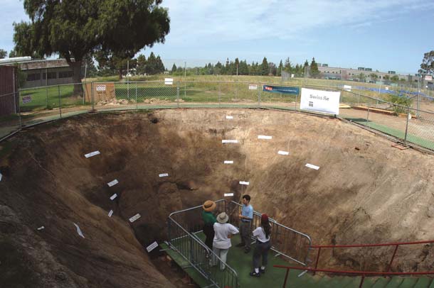
- In 2006, researchers dug a trench across the fault in Fremont’s Central Park to study evidence of past earthquakes. The trench was open to the public on weekends for several months but has since been filled. Photo by Horst Rademacher
Two of the few places where the fault is not paved over or built upon are the Mira Vista Golf and Country Club in El Cerrito and Fremont’s Central Park next to Lake Elizabeth. Geologists have taken advantage of these open sites to dig trenches up to ten feet deep across the fault. Along the trench walls they looked for disturbances in the layering of the soil, which reveal the earthquake history of the fault. Summarizing the results from the various digs, Jim Lienkemper of the USGS in Menlo Park reconstructed the Hayward Fault’s history over the last two millennia. He found that it had ruptured at least 12 times over that period. From these numbers he calculated the long-term repeat cycle. Despite surface creep, there has been a substantial earthquake on the fault roughly every 140 years. The last strong quake occurred in October 1868, so one might conclude that the East Bay is due for the next “Big One” this fall. However, the earth does not work as precisely as a Swiss clock. The repeat interval is a long-term average with a margin of error of a few decades. Nevertheless, it was the regularity of the earthquake history together with the measurements of the current creep that led USGS scientists to calculate a one-in-three probability that an earthquake of magnitude 6.8 or greater will occur on the Hayward Fault in the next 30 years, a greater probability than for any other Northern California fault.
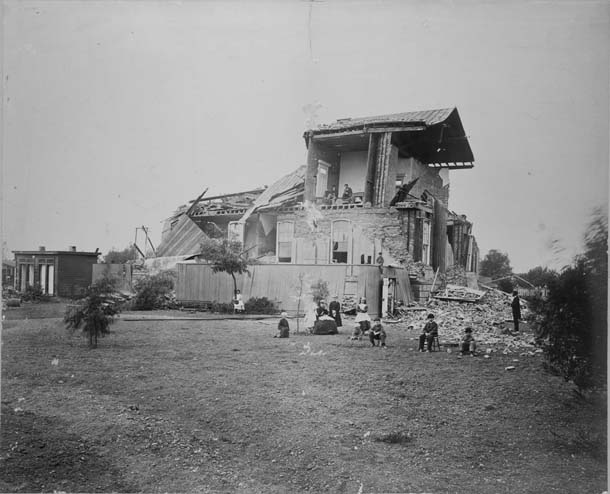
When the last such earthquake struck 140 years ago, the Bay Area looked very different than it does today. The 1860 census counted no more than 260,000 people in the whole region, Hayward had about 500 residents, and San Leandro even fewer. Those two towns bore the brunt of the seismic shaking: Almost every building in Hayward was extensively damaged or completely wrecked, while in San Leandro, the second floor of the Alameda County courthouse collapsed and many other buildings were destroyed. The most famous victim of the quake’s fury was Mission San Jose, then almost 100 years old. Its adobe walls crumbled and the church was left in ruins. During the quake the ground cracked in an almost straight line traceable for nearly 20 miles from San Leandro south to Arroyo Agua Caliente. Unlike the modest cracks in the Hayward parking lots today, this was a huge gash along which the fault’s flanks slipped about six feet past each other. All told, damage occurred across about 900 square miles from Santa Cruz to Santa Rosa, making the 1868 earthquake one of the most destructive in California’s history. Yet only 30 people died as a result of the quake.
Were a similar earthquake to occur today, the consequences in damage and human life would be immensely greater, far more serious even than those of Hurricane Katrina, says the USGS’s Tom Brocher, who leads the 1868 Hayward Earthquake Alliance, a private-public consortium of 123 organizations raising awareness about the imminent danger lurking underground.
The alliance has put together studies and scenarios from various researchers about the potential earthquake’s frightening aftermath. The immediate commercial and residential economic losses, including damage to private buildings and their contents, would surpass $120 billion. Thousands of people might be left unemployed due to damage to commercial and industrial buildings, and at least 90,000 residential units would be destroyed, displacing 220,000 residents. Major transportation infrastructure that crosses the fault, such as Interstate 580 and the Caldecott Tunnel, is likely to be unusable for months. BART and the major rail lines will be affected and might not run for weeks. Water tunnels and pipelines supplying drinking water from the Sierra to the Bay Area are likely to break and leave residential and commercial spigots dry for days or weeks.
- The Alameda County courthouse in San Leandro was essentially destroyed by the magnitude 6.8 earthquake that struck in October 1868. Photo courtesy of the Hayward Area Historical Society.
Although several major institutions like Caltrain, EBMUD, BART, and UC Berkeley have engaged in programs to seismically upgrade or retrofit their facilities, the general consensus is that the Bay Area is ill prepared to withstand such a disaster and its consequences. The alliance points out that only about 10 percent of the projected losses due to a major earthquake on the Hayward Fault would be covered by insurance. Major strides have been made since the 1989 Loma Prieta earthquake to improve the region’s resilience. Still, says Tom Brocher, a large Hayward Fault temblor is likely to be a “super catastrophe that would dramatically change East Bay communities for decades.”
Not every stretch of the Hayward Fault will witness such devastation. At its northern terminus the fault passes under Point Pinole Regional Park, a 2,000-acre oasis along the shores of San Pablo Bay in Richmond. Nearby the fault shows some creep, visible in offset curbs in Parchester Village, a neighborhood immediately south of the park. But more impressive is the natural expression of the fault just northwest of the railroad tracks in the park. For several hundred yards, a two-foot-high scarp forms an abrupt boundary between the tidal marsh and the uplands. Standing on this prominent step in the landscape, the visitor is engulfed in high stalks of wild fennel. Looking north-northwest along the scarp, one does not need much imagination to see the dangerous fault disappear into the waters of the Bay. The only sounds are the shrieking of the gulls and the soughing of the wind in the eucalyptus trees. It is so peaceful that if the wind were to die down, one could almost hear the fault creep.
Hayward Fault video: Check out KQED Quest’s TV segment on the Hayward Fault. This TV report goes in-depth on both the history of the 1968 quake and the prospects of a quake today. Definitely worth watching!

-300x221.jpg)
-300x300.jpg)
-300x195.jpg)