.jpg)
If good fences make good neighbors, the Inland Area of the Concord Naval Weapons Station has been a strangely good neighbor to the suburban Contra Costa County city it adjoins. For 65 years, ever since the navy purchased it in 1944, the 5,000-acre slab of land sloping eastward from the edge of town has been hidden in plain sight, visible from local neighborhoods and traversed by three major thoroughfares, yet strictly off-limits to most people. The terrain within those barbed-wire-bristling borders is blanked out on some older maps. Even today, with this part of the station closed and awaiting transfer to the city, with every stick of munitions gone, the site is under careful guard. Access must be arranged months in advance.
Annoying, to some. But the military presence has achieved something seemingly impossible: it has kept the land open, a generous chunk of grassland, hillside, and oak savanna that has grown in value with each passing year as the lowlands west and north of Mount Diablo have become a sheet of rooftops. “This is the last piece of central Contra Costa County where the whole range of landforms is intact,” says Bob Doyle of the East Bay Regional Park District.

- The former base is crisscrossed with train tracks and dotted with bunkers and other structures left over from decades of military use. Photo by Scott Hein, heinphoto.com.
.jpg)
The hillsides within the station are part of the Los Medanos Hills, the upland chain that links the Diablo massif to the shore of Suisun Bay, and one of the great prizes in the continuing battle over the shape and limits of growth in Contra Costa County. One third the height of Diablo, plateau-like and open, the Los Medanos Hills form a vital natural greenbelt separating eastern and central Contra Costa County. Parks and other protected open spaces cover parts of the highlands, but there are significant gaps. The Inland Area of the Concord Naval Weapons Station occupies one of the largest.
At the western foot of the little range lies Mount Diablo Creek, one of the least developed stream courses in Contra Costa County. The stream begins in a rugged canyon on the northwest side of Diablo and runs between backyard fences in Clayton and Concord before emerging onto the weapons station. Farther downstream it reaches a second military precinct, the still-active Military Ocean Terminal Concord, where great cargo cranes loom above rich marshes.
The Transition
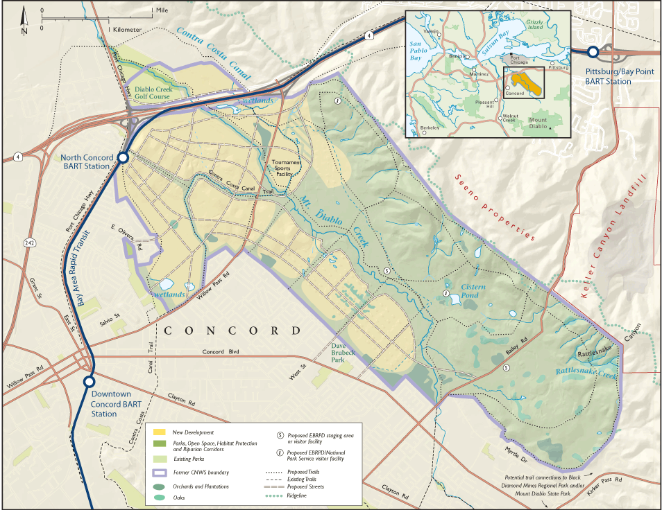
- Map by Ben Pease, peasepress.com. Click for larger version.
In many communities, the shuttering of a nearby military base is regarded as a disaster. Not so in Concord. Long before the Inland Area was formally declared surplus, in March 2007, the city had annexed the site. The city council seemed to see the land as a blank slate, a void to fill in with more Concord: the same pleasant suburbia, supersized. Prominent area home builder Albert Seeno Jr. observed, “It’s next to major freeways, adjacent to a BART station. It’s an infill project. It’s flat. It’s ideal. I grew up in Concord. It would be nice to build the last available parcel.”
The local public, it soon became clear, had other ideas. Above all, it wanted less extensive building and much more open space. Regional organizations declared their interest as well. A novel coalition of base neighbors, open space advocates, housing activists, “smart growth” proponents, and local unions and faith-based groups came together to promote quite another vision for the site. On the north and west, a zone of concentrated development would hug the existing North Concord BART station. To the south and east a great regional park would protect the base and slopes of the Los Medanos Hills.
After years of controversy, the City of Concord has moved some distance toward this concept, adopting what it calls the Clustered Villages Plan. State and federal environmental reviews are currently under way. If the planned time line holds, the final release of the land could come as early as January 2011. There is debate still to come about the final scope of development, but the creation of a major park on more than half of the site is widely supported. The East Bay Regional Park District’s 2008 Measure WW earmarked $16 million for the acquisition, restoration, and development of this property specifically.
The Place
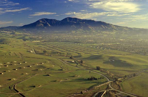
- Mount Diablo looms over central Contra Costa County’s suburban sprawl, which ends abruptly at the edge of the shuttered navy base. The thin green band of Mount Diablo Creek lies inside the boundary of the proposed new regional park here. Photo by Bob Ecker.
The first thing that impresses you, out on the site, is the military imprint: the vast number and extent of ammunition bunkers, train tracks, and roads. The second is the land’s sheer openness. The terrain is simple: the hills, a ridgeline growing gradually higher toward the south; little oak-lined drainages coming down; a broad apron or bajada of overlapping alluvial fans; and at the bottom of the slope the course of Mount Diablo Creek, tree-lined but usually dry. A little rise in elevation is enough to show you much of central Contra Costa County, from Diablo to tidewater. As in the desert, simple forms and lack of concealment cause you to underestimate distances–or perhaps to see them more realistically than we do when nearer patterns complicate the view. At some 2,500 acres, the proposed new park would be larger than Tilden Regional Park in the Berkeley Hills, yet it seems curiously small.
The third thing you notice is grass, lots of it. This is indeed a piece of “golden” California, the color and texture of the land determined by the annual grasses that set seed early and die. Annual grassland covers over 80 percent of the site, though patches of the native perennial species–purple needlegrass, California fescue, and others–hang on in folds of the hills.
Whatever its composition, undeveloped grassland is a rarity in this part of the world, and it provides a lot of habitat. Out in the fields you can’t miss the western fence lizard and the black-tailed jackrabbit. Stay a little longer and you are likely to see a rattlesnake, gopher snake, king snake, or all three. California ground squirrels burrow throughout the area, and many other species borrow these tunnels for shelter. The California vole, western harvest mouse, and Botta’s pocket gopher thrive here, as do the coyotes that eat them all. Western meadowlarks, horned larks, killdeer, and mourning doves nest in the grassland. There are at least a few pairs of burrowing owls, a California “species of special concern.” Hawks, kestrels, and falcons by day and owls by night patrol for their mostly rodent prey.
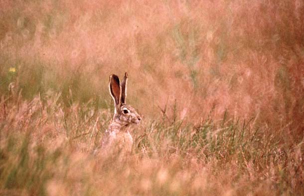
- Jackrabbits are plentiful here, and so are the coyotes that hunt them. Rabbits and numerous rodents also attract raptors to the weapons station’s wide-open grasslands. Photo by John Keibel, behindthebarbedwire.com.
Much of the wildlife action on the station either occurs in, or depends on, the 9 percent of the land that is something other than grassland (or developed ground): seasonal and permanent ponds and wetlands, stream courses, and trees.
- A California tiger salamander, a federally threatened species, up the hill from Cistern Pond. Photo by John Keibel, behindthebarbedwire.com.
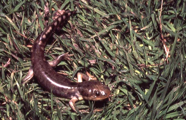
In the south half of the station, in and along the hills, are some 20 stock ponds, watering holes, and seepage pools. These are breeding grounds for the California red-legged frog and California tiger salamander, both threatened species, as well as for western toads and Pacific chorus frogs.
The largest pool, and the only one to retain water year-round, is Cistern Pond north of Bailey Road. Judging by rock fragments from toolmaking, the site was used by Chupcan Indians, a tribelet of the Coast Miwok. Later it was tapped for a dairy ranch; an old windmill and the namesake cistern remain. It was here that the Department of Fish and Game planted red-legged frog tadpoles in 1982. Alone of the station’s waters, Cistern also supports the western pond turtle, a species of state concern.
While the ponds are safely in the regional park zone, some other wetlands lie in the path of development. The most interesting of these is at the extreme western corner of the site, where lingering small ponds and marshes mark a past course of Mount Diablo Creek. The soils in the northern third of the site lend themselves also to formation of seasonal wetlands of the kind where tiger salamanders breed, though those amphibians have not been observed here.
Mount Diablo Creek is a lifeline of the station, less for the water it seasonally carries than for the trees it supports. A ragged but recovering riparian forest of willows, cottonwoods, oaks, and ashes draws many nesters, including hawks, kestrels, owls, downy woodpeckers, Anna’s hummingbirds, and Pacific-slope flycatchers. Arboreal salamanders live in the streamside strip and bats may roost there.
.jpg)
- Mount Diablo Creek’s riparian woodlands are very limited, but they provide critical wildlife habitat, especially for nesting and roosting birds. Photo by Scott Hein, heinphoto.com.
In a landscape of grass, the taller tree is an event. Valley oaks appear mostly to the south of the site, spaced out in the formation known as oak savanna, rarely found intact these days because the gentle ground it occupies is so easy to build on. Up in the canyons, buckeyes and blue and coast live oaks make pockets of woodland.
Another small portion of the site is covered in groves of eucalyptus and Coulter pine, most planted in the 1960s and 1970s as a forestry experiment. The taller eucalyptus trees draw nesting red-tailed and red-shouldered hawks, great horned owls, and golden eagles. Owls roost in the pines. Old walnut trees, surviving from pre-military days, are the favored nesting ground of the locally abundant loggerhead shrike, another species of state and federal concern. Shrikes are birds of prey that lack the powerful talons of raptors; instead they impale their kills on sharp points, like thorns–or the barbs on barbed-wire fences.
Plans
Under the Clustered Villages alternative, all the territory west of the creek will be developed, with generous internal greenbelts. Open space advocates wanted everything east of the creek for the regional park, but did not quite achieve their goal: The preferred alternative maps a considerable swath of city beyond the watercourse, adjoining Highway 4 on either side. A 300-foot-wide creekside buffer zone would remain open throughout.
The East Bay Regional Park District has been discussing the creation of a park here since the base closed in 1999, but the plans remain conceptual, since the district does not even own the land yet. Those plans, largely reflected in the city’s Clustered Villages alternative, address the broad categories of public access and recreation, education and interpretation, and restoration and preservation. An old hillside bunker on the north side might house a visitor center, serving this park and the Tidal Area’s Port Chicago Memorial, where the newest unit of the National Park Service (designated in October 2009) commemorates a disastrous 1944 explosion. The site is traversed by miles of old roadways, fire trails, and rail lines that could provide access for hikers, bikers, and equestrians. There is also substantial flatland, a rarity in new regional park lands, suitable for campgrounds, picnic grounds, and equestrian staging areas.
Whatever else it is, the new park will of necessity become a laboratory for ecosystem restoration. Impressive though its natural assets are, this landscape is rather the worse for wear since the Spanish arrived on the scene, and even since 1944, when the navy took over.
.jpg)
- “Bunker City” lies just west of Mount Diablo Creek. Under current proposals, this geometric landscape of bunkers and access roads will give way to new residential development. Photo by Scott Hein, heinphoto.com.
Before the European conquest the site was inhabited by the Chupcan people. There was a large village at the northwest corner of the site at the corner of Olivera and Willow Pass roads (probably on the former course of Mount Diablo Creek). Pronghorn antelope and tule elk, as well as grizzly bear, ranged the hills. The landscape would have been open then as now, but somewhat greener in the summer with the perennial native grasses. Oaks would have been bigger, though perhaps not much more extensive. Mount Diablo Creek, though always seasonal, probably ran for more of the year, in a wider and better-developed riparian forest. Its spring flows supported migrating steelhead, and lingering pools would have served amphibians much as the artificial ponds do today.
During the early 19th century, under the pressure of grazing, exotic annual grasses displaced the perennials. Yet memories from as late as the 1940s suggest a greater floristic richness than today’s. Arlita D’Andrea Crockett, who grew up on the future base, recalls, “When we were kids, you know, from here to Antioch in the springtime, everything was wildflowers. I don’t know where they’ve all gone.”
What is to blame for such changes? Several factors are suspected, including pollution, a drying of climate, and mismanagement of grazing (too little being as harmful as too much). Today, the grassland community at the weapons station has to be called impoverished, with three quarters severely infested with yellow star thistle.
A resurgence of perennial grasses, all agree, would be desirable. Though the annual-grass monopoly is tough to break, the perennials survive in steeper, shadier spots, and their durable seeds lie in the soil everywhere like some subtle, valuable spice; the trick is to set the conditions that will allow them to germinate and thrive. The primary tool for such cases, says the park district’s David Amme, is carefully calibrated grazing.
There might even be a place in the future for tule elk, a species that was extirpated early here but has already been back once. In 1977, as the state was working to bring the elk back from near-extinction, the navy volunteered to host a herd and took five animals. Twenty-nine years later, a few weeks after Congress made base closure final, the thriving herd of 39 animals was trapped and removed to state lands elsewhere.
Another focus of interest is the Mount Diablo Creek channel, which has suffered due to historic re-routing, upstream development, and tree removal. Some reaches are ditchlike, almost bare of vegetation, and the normal pattern of alternate pools and riffles is rare. Ongoing bank erosion, a problem because of the sediment it dumps, is also a hopeful sign that the confined stream is trying to meander and reestablish its floodplain. The best mark of restoration success would be the return of the steelhead; this would require not only better conditions on the weapons station site but the removal of barriers upstream and down.
The Eastern Horizon
All good plans for this regional park are overshadowed, perhaps literally, by a quirk of its boundary. The former base’s northeast fence line does not follow the crest of the hills; for two long stretches, it lies downslope. The ridgeline that forms the eastern horizon of the prospective park–and of all Concord–is privately owned and under the control of the City of Pittsburg and Keller Canyon Landfill.
The landfill owner has no intention of developing the ridge, but Pittsburg’s General Plan speaks with two voices. On one hand it mentions a greenbelt along the border with Concord. On the other, it maps out development of the entire tract, though parts are steep and slide-prone, at a density of six or seven dwelling units per acre. This plan would theoretically allow houses to appear on the skyline, and within the watershed, of the park. (See sidebar for more info.)
The ridgetops have some of the same creatures found on the former weapons station, including burrowing owls, tiger salamanders, and red-legged frogs. (And you will seldom see so many kestrels anywhere.) They also have something that the core park area lacks: eastward views, extending, on clear winter days, to the white Sierra Nevada. This great ramp of hills leading north to Suisun Bay and south to Mount Diablo seems made for a long-distance recreational trail.
To fulfill its promise, the future regional park on the Concord Naval Weapons Station needs a buffer zone consisting at least of the land that drains into, or can be seen from, the Concord side. From a regional perspective, something more generous is to be hoped for: a broad Los Medanos greenbelt, comprising public lands and private lands under conservation easement, and securing the whole magnificent continuum from Diablo to the tide. “When you get up on the ridgeline and see what’s possible,” says Seth Adams of Save Mount Diablo, “it’s just world class.”
CNWS and Los Medanos Hills Resources
Behind the Barbed Wire (book by John Keibel), behindthebarbedwire.com
CNWS Neighborhood Alliance, cnws-alliance.com
Concord Community Reuse Project, concordreuseproject.org
Greenbelt Alliance, greenbelt.org
Save Mount Diablo, savemountdiablo.org
Save Our Hills (Pittsburg), saveourhills.org
-300x154.jpg)

.jpg)