.jpg)
Not willing to give up its secrets easily, the land is unpolished and the trail less traveled by. It holds deep and interconnected stories of human toil and California’s history. Long ago, it drew many wanderers from far-away reaches, some by wagon on the Emigrant Trail, others by long ocean voyages. Placing foot to earth here connects you to their history.
The journey ended for these settlers where you will begin yours—on the Franklin Ridge. Located in central Contra Costa County, the Franklin Ridge begins at Mount Wanda, part of the John Muir National Historic Site in Martinez, and extends northwest for some ten miles towards Hercules. The Dutra Loop Trail lies in the middle of the Franklin Ridge, on Dutra Ranch and Sky Ranch, two historic properties now owned by the Muir Heritage Land Trust.
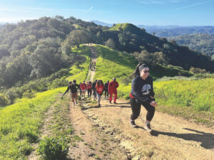
The Dutra Loop Trail begins on Contra Costa County Feeder Trail #1, a wide dirt path that was once a stagecoach road used to transport travelers between Martinez and Richmond. You’ll travel for about a mile uphill through grasslands dotted with oaks and shrubs.
Past the Sky Ranch kiosk, the trail’s left fork rises to the top of a 1,000-foot-high peak—the highest on the ranch. A bench invites you to stop and take in the sweeping vista beginning with Mount St. Helena in the distant north and the ridges above Napa Valley in the northwest, moving southward to the Sacramento River as it passes through the Carquinez Strait and southeast to Mount Diablo. To the south, the highest ridge of Briones Regional Park lines the horizon.
The nearby tree-covered ridge to the northwest is the Fernandez property, open space that the Muir Heritage Land Trust (MHLT) is now raising money to purchase. To the east, the bell tower of John Muir’s Victorian mansion sits among the treetops, marking the edge of the town of Martinez. On a very clear day, the snow-covered Sierra might just be visible.
This open, oak-studded landscape, typical of the Bay Area’s inner coastal hills, is prime ranch land. Nearly 200 years of cattle ranching have greatly influenced the human and natural history of the area. With room to roam, ample water sources, and lots of edible vegetation, the animals made themselves at home here. Even today the hoof-etched lines in the hills announce their presence.
Ranching proved very successful for those early pioneers. According to Mae Fisher Purcell’s florid account in her 1940 History of Contra Costa County, “Cattle was the wedge which opened the way to prestige, grandiloquence and opulence not theretofore dreamed of by the dons, land grantees and owners of huge acreages.”
Ranchers often owned thousands of cattle apiece, and the animals wandered unimpeded. Owners would round them up only for the annual rodeos, where cattlemen and their families gathered from a 50-mile radius. The larger rodeos brought together 300 or more people and upwards of 30,000 head of cattle. Sorting and branding went on for a week or more.
Cattle ranching began on the Franklin Ridge when Don Ignacio Martinez applied for a Spanish land grant of 17,000 acres in 1823. He brought in breeding stock and small herds, turning them loose on his vast estate. Martinez named his holdings Rancho El Pinole, and they extended over land that today includes most of the Franklin Ridge, Pinole, Rodeo, Crockett, and Martinez.

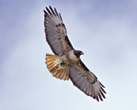
- Like most of our coastal range grasslands, Dutra Ranch isdominated by exotic annual grasses that turn golden in summer. But theland still supports abundant rodent populations, which in turn feedraptors like this red-tailed hawk. Photo by Matt Brown.
The next wave of settlers to the area began in the mid-19th century. Dr. John Strentzel, John Muir’s father-in-law, purchased his property in 1853. Several miles north, James McHarry purchased 500 acres in 1856 for his cattle ranch. Although they lived at opposite ends of the Franklin Ridge, the McHarrys, Muirs, and Strentzels all knew each other. “John Muir would come to call,” McHarry’s great-granddaughter, Miriam Awenius, said recently. “Muir would ask permission for my grandfather’s daughter Ada to go horseback riding with Muir’s daughter Wanda.”
Leading from the Sky Ranch peak, the trail winds toward Dutra Ranch. Both ranches lie at the heart of the 10,000-acre Franklin Ridge, between the Muir property and McHarry Ranch. Manuel Dutra emigrated from Portugal to establish his cattle ranch in 1917. The trail you walk here was also part of the Martinez-Richmond stagecoach route, and probably John Muir’s stomping ground. “It’s inconceivable that Muir didn’t walk that land,” says Glenn Fuller, superintendent of the John Muir National Historic Site. “He loved tromping in those hills.”
The Muir Heritage Land Trust bought the 159-acre Dutra Ranch early this year. The purchase was the linchpin in establishing 660 acres of contiguous open space, an important corridor for wildlife and trail linkages. “The Franklin Ridge is surrounded by cities,” says mhlt Executive Director Tina Batt. “Right now we are fighting to keep much of it permanent open space, and I like to think we are continuing John Muir’s work by setting this land aside as a special place for wildlife as well as people.”
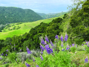
Grassland dominates any walk here, and the current state of the grasslands tells the tale of ranching history. The sere, golden brown hills are mostly covered with nonnative Mediterranean grasses, plants that cattle ranching helped spread. The grasses are annuals, turning from vibrant green in early spring to golden brown during the dry months.
Before the early settlers arrived, native perennial grasses covered the grasslands of the Franklin Ridge. These native grasses found it difficult to compete with the introduced plants, but they can still be found, including scattered stands of purple needlegrass that grow on the Dutra and McHarry ranches. The plant grows in small, dense bunches and may be seen near the trail. Ironically, properly timed grazing today can increase purple needlegrass cover by reducing the density of nonnative grasses.
The grassland plant community supports a robust rodent population, which in turn feeds snakes, mammals, and raptors. In the fall, resident rodents are preparing for winter. Among them are the dusky-footed wood rat and the meadow vole, both busy fortifying their nests. The wood rat makes a nest of twigs and leaves on the ground or in the trees, where it stores winter food. The voles create extensive runways through the grass to their burrow entrances.
With such abundant food sources, the land provides perfect conditions for raptors — Cooper’s hawks, red-tailed hawks, northern harriers, white-tailed kites, and peregrine falcons. Near dusk or even during a daytime darkened by clouds, you might catch a glimpse of a great horned, barn, or screech owl.
Less than a mile from the Sky Ranch peak, you’ll head downhill to reach the Dutra family homesite, now a frequent resting spot for a small herd of cattle. Traces of the family’s decades of working the land are reduced to a timeworn granary, an old corral, the well, a few rusted farm implements, and three olive trees. Time has vanquished the home, the barn, the windmill.
Manuel Dutra’s granddaughter, Delores Moneypenny, remembers playing in the hay barn as a girl, and “sledding” down the dry hills on pieces of cardboard, dodging cow droppings. “We decided to sell to the land trust,” she explains, “because the land is our heritage, and because our children, grandchildren, and great grandchildren will be able to go up and enjoy it like everyone else. The view is beautiful.”
Rancher Bob Chapman leases the land for his cattle, an unusual Angus-Brahman mix. Their horns look formidable but the animals are docile. If you meet them, just walk around them and don’t get between a mother and her calf. Chapman has been ranching in the area for more than 35 years and loves the life, though it’s hard work: “Raising cows is 24/7,” he says.
The Muir Heritage Land Trust continues to lease the property for grazing to clear out potential fuel for fires. MHLT Stewardship Associate Beth Pardieck is leading a project to encourage the regrowth of native freshwater marsh plants by fencing off natural seeps and a stock pond from the cattle. Seasonal creeks, natural springs, and seeps feed the upper reaches of both Franklin Creek and Rodeo Creek. With the help of the East Bay Conservation Corps, the land trust recently restored creek areas on Dutra Ranch.
After leaving the homesite, you are soon cooled by an oak-bay woodland. The woodlands you’ll see throughout the property are mostly on north-facing slopes, along streams, and in ravines. Although coast live oak is dominant, some stands are mixed with a healthy number of fragrant California bay trees.
In the fall, black oaks and big leaf maples brighten the landscape with their fall colors. Aided by crisp autumn breezes, the black and valley oaks start to shed their leaves for the winter. Watch—and listen—for red-capped acorn woodpeckers as they get ready for winter by drilling holes in trees to store their acorns.
Nearing the end of the loop, you’ll pass through a gate back onto Sky Ranch. Along the way, the woodland opens up to chaparral and scrub habitat. Among the dominant shrub species are coyote brush, chamise, and California sagebrush. Poison oak is also common, and in the fall it dresses itself with leaves of showy red.
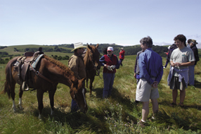
- Ranchers Joe and Laura Matta graze cattle on Gustin Ranch, owned by the Muir Heritage Land Trust. Photo by Scott Hein.
Cattle ranching continues to influence the Franklin Ridge—mostly by helping to preserve it. Descendants of those early ranchers speak of protecting their family lands. Bill Fernandez’s great grandfather Bernardo left his native Portugal at age 13, sailed around the world, and settled in what is now Pinole. The family still owns 700 acres of the land that Bernardo purchased 150 years ago, and they plan to sell it to the Muir Heritage Land Trust. “It’s a prime opportunity to leave a legacy in honor of my great grandfather,” Bill Fernandez says. “[It’s especially important] with development in the county going crazy.”
The ranch is still grazed, but remains gently used and fertile habitat for wildlife, including several special status species — the Alameda whipsnake among them. The whipsnake has been captured near the Fernandez property, and biologists believe the Franklin Ridge is home to the elusive reptile. In 2000 the United States Fish and Wildlife Service designated the entire Franklin Ridge as Alameda whipsnake critical habitat. The agency vacated the designation in 2003 due to legal challenges, but it will most likely be re-proposed.
The fast-moving snake garnering so much attention is sooty black with yellow-orange stripes running its 5-foot length. It primarily lives in the types of scrub communities found throughout the Franklin Ridge. Rock outcrops are important habitat features because that’s where the Alameda whipsnake finds its favorite food, the Western fence lizard. Whipsnakes will venture onto grasslands, up to four miles from any scrub. While the impact of grazing on the snake population is not fully known, it is clear that overgrazing land can degrade the snake’s habitat. The continued survival of the whipsnake depends on stemming habitat loss and fragmentation.
Someday, you may be able to continue from this trail to Fernandez Ranch and beyond on the Bay Area Ridge Trail. If the efforts of the Muir Heritage Land Trust and numerous other agencies are successful, Feeder Trail #1 and the Dutra Loop Trail will become part of the 500-mile-long Ridge Trail.
The trails, the land, the natural resources, the history of this area are all intertwined. The cattle ranches have been a part of each of them. The cattle disrupted and altered the land long ago, yet have helped keep it an island of open space in a sea of asphalt and stucco. Their imprints in the soil and in history lead us to the preservation of the land, to the creation of a vital open space corridor for wildlife and for people.
Getting There
Take Highway 4 to the Alhambra Avenue exit. From the east, turn left (south) onto Alhambra Avenue, go under the freeway, and then turn right onto Franklin Canyon Road. From the west, turn right onto Alhambra Avenue and then immediately right onto Franklin Canyon Road. Take Franklin Canyon Road about 1 mile to Dutra Road; turn left. The trailhead, marked “Contra Costa County Feeder Trail #1,” is about one-tenth of a mile up the road. Watch for the yellow end sign on the left just before the horse stables. Limited parking is available on the trail side of the road.